تم العثور على 1 إدخال
عدد النتائج المعروضة في الصفحة
عرض النتائج ك:
نتائج البحث
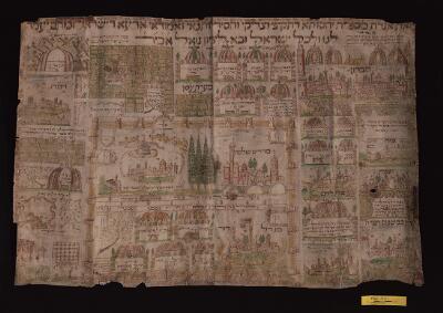
1. Schematic map
- الوصف:
- Colourful schematic map of Jerusalem, employing the tropes of Jewish folk art of the 17th–18th centuries. Jerusalem is depicted as a walled city with many towers and is surrounded by illustrations denoting the sites of the tombs of various biblical figures and rabbinic sages in the wider Land of Israel. A title is written in a large square script at the top of the map: זאת אגרת מספרת יחסותא דתקיפי וצדיקי וחסידי ותנאי ואמוראי ארעא דישראל זכתום יעמד לנו ולכל ישראל ובא לציון גואל אכי״ר. Towards the bottom, on the left-hand side, there is a note by the artist: אני שמואל בן ישי מסיניגאליה העתקתיו מאחר שהובא מארץ רחוקה ח׳ ימים לחדש תשרי, ‘I, Samuel b. Yišay from Senigallia, copied it from one that had been brought from a distant land, on the 8th of Tišri’. Jerusalem itself is depicted as being divided into two by the Western Wall, with the Tower of David sitting prominently in the lower section. Four cypresses stand above the wall, dividing the Dome of the Rock from the Al-Aqsa Mosque (called מדרש שלמה). Each item is identified in carefully penned Hebrew, and there are occasional pious verses. The whole map is surrounded by a decorative border, lost in part.Condition: Creased, slightly torn at edges, faded and discoloured