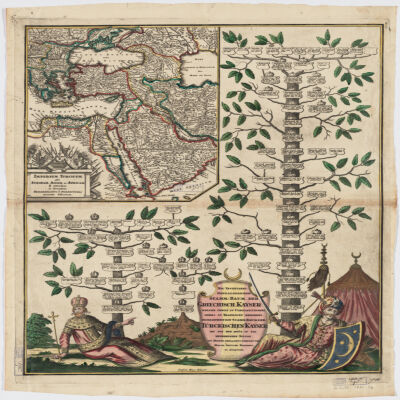
Covers Libya, Egypt, Sudan, the Arabian Peninsula, Lebanon, Syria, Iraq, Iran, the Balkan Peninsula, Turkey, Greece, Armenia, Azerbaijan and portions of Ethiopia and Russia.Relief shown by hachures and pictorially.Colored in outline.Inset: Neu Inventiert. Genealogischer Stamm-Baum Der Griechisch. Kaÿser Welche Theils Zu Constantinopel Theils Zu Trapezunt Residiret : desgleichen ein StammBaum Der Türckischen Kaÿser Bis Auf Den Heüt Zu Tag Regierenden Sultan / ins Kupfer gebracht u. verlegt von Matth. Seütter.Includes ill.In German and Latin.Electronic reproduction. Cambridge, Mass. : Harvard College Library Digital Imaging Group, 2009. (Open Collections Program at Harvard University. Islamic Heritage Project). Copy digitized: XXXXX Library: [call no.].
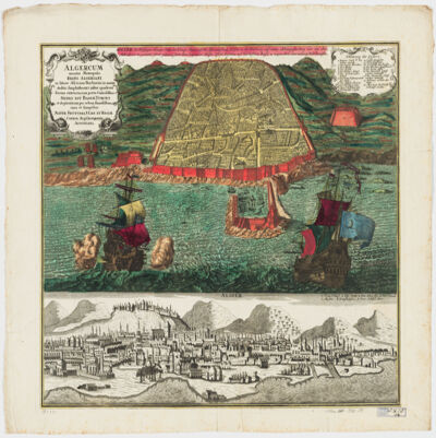
cura et sumptibus Matth. Seutteri.Birds-eye view.Appears in: Atlas novus sive tabulæ geographicæ totius orbis faciem, partes, imperia, regna et provincias exhibentes / exactissima cura iuxta recentissimas observation Matthaeo Seutter, [1745?]. Vol.1, map No. 137.Includes a close-up view of Algiers and index.In German with a title in Latin.Electronic reproduction. Cambridge, Mass. : Harvard College Library Digital Imaging Group, 2009. (Open Collections Program at Harvard University. Islamic Heritage Project). Copy digitized: Map Coll (Pusey) : MAP-LC G8244.A6 A3 1730 .S4.
Nach Russischen und and Handschriften entworsen Strasburg bey Joh. Georg Treuttel ; I. P. Kremer delin ; B. F. Leizelt sc.Relief shown by hachures and pictorially.Prime meridian: Ferro.Includes ill.Map in German and French.Electronic reproduction. Cambridge, Mass. : Harvard College Library Digital Imaging Group, 2009. (Open Collections Program at Harvard University. Islamic Heritage Project). Copy digitized: Map Coll (Pusey) : MAP-LC G7060 1765 .T7.Electronic reproduction. Cambridge, Mass. : Harvard Geospatial Library, 2009. Georeferenced image for use in a GIS.
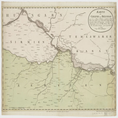
nach den militœrischen Handkarten des Prinzen Eugen der Grafen Khevenhüller, Marsigli und Pallavicini geographisch aufgetragen, und nach den zuverloessigsten Nachrichten, und Reisebeschreibungen berichtiget im Jahre 1788 von Herrn Maximilian Schimek ; J. Alberti Sculp. ; F. Müller Scrip.Shows locations and dates of battles.Covers Serbia, Albania, Bosnia, Croatia, Dalmatia and portions of Macedonia and Hungary.Relief shown pictorially.Prime meridian: Ferro.North oriented toward the left.Includes ill.
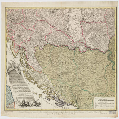
nach den besten Originalzeichnungen Charten und Beschreibungen entworfen von Herrn Carl Schütz ; gestochen von C. Schütz und F. Müller.Covers Bosnia and Hercegovina, Slovenia, Croatia, Serbia and portions of Italy, Hungary, Bulgaria, Albania and Macedonia.Relief shown pictorially.Includes ill."C. Priv. S.C.M.""Erklærung der Illumination - Roth ist oesterreichisch, Grün türkisch , Gelb venetiatisch, Violet gehert der Republik Ragusa, Blau einen Theil des Kirchenstaats, und Orangefarb dem Koenig von Naepel."Electronic reproduction. Cambridge, Mass. : Harvard College Library Digital Imaging Group, 2009. (Open Collections Program at Harvard University. Islamic Heritage Project). Copy digitized: XXXXX Library: [call no.].
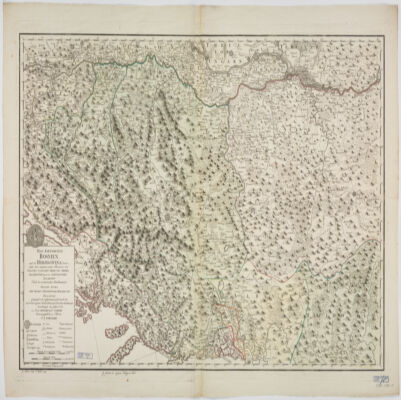
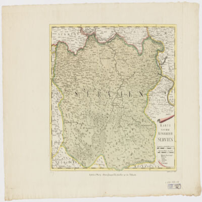
Gestochen von F. Müller.Covers also portions of Albania, Macedonia, Bulgaria, Hungary, Romania, Croatia and Bosnia and Hercegovina.Relief shown pictorially.Includes ill.
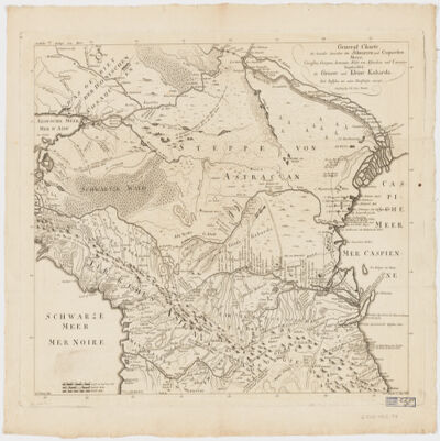
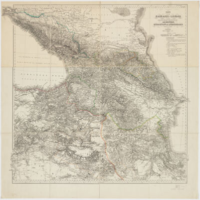
Charten, Reisen und astronomischen Orstbestimugen gezeichnet von I. C. M. Reinecke.Covers Azerbaijan, Georgia and portions of Armenia and the Russian Federation.Relief shown by hachures.Colored in outline.Includes note.Electronic reproduction. Cambridge, Mass. : Harvard Geospatial Library, 2009. Georeferenced image for use in a GIS.Electronic reproduction. Cambridge, Mass. : Harvard College Library Digital Imaging Group, 2009. (Open Collections Program at Harvard University. Islamic Heritage Project). Copy digitized: Map Coll (Pusey) MAP-LC G7120 1802 .R4.
bearbeitet und gezeichnet von H. Kiepert.Relief shown by hachures and spot heights.Prime meridian Greenwich and Ferro.Colored in outline.Electronic reproduction. Cambridge, Mass. : Harvard College Library Digital Imaging Group, 2009. (Open Collections Program at Harvard University. Islamic Heritage Project). Copy digitized: Map Coll (Pusey) : MAP-LC G7120 1854 .K5.Electronic reproduction. Cambridge, Mass. : Harvard Geospatial Library, 2009. Georeferenced image for use in a GIS.
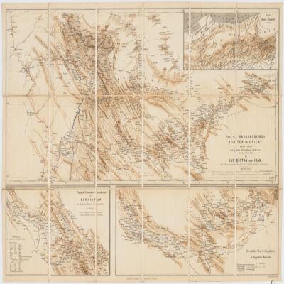
nach dessen Originalskizzen redigirt von H. Kiepert.Covers portions of Turkey, Iraq and Iran.Relief shown by shading.Prime meridian: Greenwich and Paris.Inset: Route in Nord-Persien (Scale 1:600,000).Ancillary maps: Türkish-Persischer Grenzbezirk in Kurdistan im doppelten Maβstab der Hauptkarte (Scale 1:400,000), Der mittlere Theil der Hauptkarte im doppeltem Maβstabe (Scale 1:400,000)."Druck v. Fr. Schwabe, Berlin".Includes lexicon German-Turkish-Persian.In German with place names in Turkish and Persian.Electronic reproduction. Cambridge, Mass. : Harvard College Library Digital Imaging Group, 2009. (Open Collections Program at Harvard University. Islamic Heritage Project). Copy digitized: XXXXX Library: [call no.].
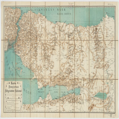
nach älteren Quellen (v. Moltke, Heinrich Kiepert, Brit. Admiralitätskarten, v. d. Goltz, v. Diest u.a.) und eigenen Aufnahmen im Jahre 1900 gezeichnet von Rudolf Fitzner ; Hof. Stdr. v. J. G. Tiedmann Nachf.Relief shown by hachures. Depths shown by contours.Includes index.Electronic reproduction. Cambridge, Mass. : Harvard College Library Digital Imaging Group, 2009. (Open Collections Program at Harvard University. Islamic Heritage Project). Copy digitized: Map Coll (Pusey) : MAP-LC G7433.I8 1900 .F5.Electronic reproduction. Cambridge, Mass. : Harvard Geospatial Library, 2014. Georeferenced image for use in a GIS.
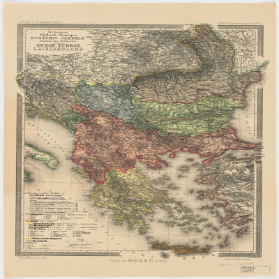
Redigiert v. Dr. K. Peucker ; Rudolph Maschek sculps ; Kartogr. Anst. v. Th. Bannwarth.Covers Romania, Bosnia and Hercegovina, Montenegro, Bulgaria, Macedonia, Albania, Greece, Cyprus and portions of Russia, Hungary, Croatia and Italy.Relief shown by hachures and spot heights. Depth shown by hachures.From: Scheda & Steinhauser Atlas. Sudost-Europa (Balkanländer) No. XV.Prime meridian: Greenwich and Ferro.Electronic reproduction. Cambridge, Mass. : Harvard College Library Digital Imaging Group, 2009. (Open Collections Program at Harvard University. Islamic Heritage Project). Copy digitized: Map Coll (Pusey) : MAP-LC G6800 1903 .P4.Electronic reproduction. Cambridge, Mass. : Harvard Geospatial Library, 2011. Georeferenced image for use in a GIS.