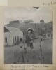
Genre/Subject Matter:View of the walls of a fort on Hormuz Island, perhaps the Fort of Our Lady of the Conception, also known as the Portuguese Castle, the construction of which was completed by the Portuguese after conquering the island in 1515.Two men stand in front of the crumbling walls, one immediately right of centre and one at far right, perhaps for the purpose of providing a scale.Inscriptions:Ink, below image: 'Exterior of Fort, Hormuz, showing mouldering walls.'1 b&w silver gelatin printDimensions:145 x 200 mmCondition:The print is in good condition, though the mounting paper is heavily foxed and crumblingFoliation:‘12’Process:Silver gelatin
Imprint:Published by James Horsburgh, Hydrographer to the East India Company.Distinctive Features:Relief shown by shading. Depth shown by soundings.Nautical chart of the northern shores of the Persian Gulf showing the coastline east of Shatt al-Arab to Bushire [Bushehr] compiled from the surveys carried out by the Bombay Marine’s officers between 1820 and 1829.Shows sandbanks and rock hazards; location of ruins and old entrance of Indian River marked.1 mapDimensions:504 x 599 mm, on sheet 565 x 777 mm
Imprint:General Staff India.Distinctive Features:Sketch map issued as an ‘Appendix B (1) Serial No. 12 D
2’ to illustrate British military operations on the Euphrates River from 26 June to 25
July 1915. Shows swamps and inundated fields with position for safe landing
marked.Marked ‘For Official Use Only’.In the left-hand corner: ‘S.D.O. No. 1356, September,
1915’.1 mapDimensions:200 x 330
mm
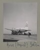
Oblique photograph taken in the course of an aerial reconnaissance of the Qatar Peninsula on 11 October 1935 by Squadron Leader J H Dand, Air Headquarters, British Forces in Iraq, Hinaidi. There is a report on the reconnaissance at IOR/R/15/2/159, folios 18-20.Inscribed: 800 feet.1 black and white photographDimensions: 180 x 180 mm.Foliation: the folio number, 28, is written in pencil, enclosed in a circle, and appears below the photograph near the right edge of the recto side of the folio. A previous foliation number has been crossed out.
Oblique photograph taken in the course of an aerial reconnaissance of the Qatar Peninsula on 11 October 1935 by Squadron Leader J H Dand, Air Headquarters, British Forces in Iraq, Hinaidi. There is a report on the reconnaissance at IOR/R/15/2/159, folios 18-20.Inscribed: 800 feet.1 black and white photographDimensions: 180 x 180 mm.Foliation: the folio number, 27, is written in pencil, enclosed in a circle, and appears above the photograph near the right edge of the recto side of the folio. A previous foliation number has been crossed out.
Oblique photograph taken in the course of an aerial reconnaissance of the Qatar Peninsula on 11 October 1935 by Squadron Leader J H Dand, Air Headquarters, British Forces in Iraq, Hinaidi. There is a report on the reconnaissance at IOR/R/15/2/159, folios 18-20.Inscribed: 700 feet.1 black and white photographDimensions: 180 x 180 mm.Foliation: the folio number, 22, is written in pencil, enclosed in a circle, and appears below the photograph near the right edge of the recto side of the folio. A previous foliation number has been crossed out.
Oblique photograph taken in the course of an aerial reconnaissance of the Qatar Peninsula on 11 October 1935 by Squadron Leader J H Dand, Air Headquarters, British Forces in Iraq, Hinaidi. There is a report on the reconnaissance at IOR/R/15/2/159, folios 18-20.Inscribed: 800 feet.1 black and white photographDimensions: 180 x 180 mm.Foliation: the folio number, 26, is written in pencil, enclosed in a circle, and appears below the photograph near the right edge of the recto side of the folio. A previous foliation number has been crossed out.
Oblique photograph taken in the course of an aerial reconnaissance of the Qatar Peninsula on 11 October 1935 by Squadron Leader J H Dand, Air Headquarters, British Forces in Iraq, Hinaidi. There is a report on the reconnaissance at IOR/R/15/2/159, folios 18-20.Inscribed: 800 feet.1 black and white photographDimensions: 180 x 180 mm.Foliation: the folio number, 24, is written in pencil, enclosed in a circle, and appears below the photograph near the right edge of the recto side of the folio. A previous foliation number has been crossed out.Condition: the caption is faint and not entirely legible.
Oblique photograph taken in the course of an aerial reconnaissance of the Qatar Peninsula on 11 October 1935 by Squadron Leader J H Dand, Air Headquarters, British Forces in Iraq, Hinaidi. There is a report on the reconnaissance at IOR/R/15/2/159, folios 18-20.Inscribed: 800 feet.1 black and white photographDimensions: 180 x 180 mm.Foliation: the folio number, 23, is written in pencil, enclosed in a circle, and appears above the photograph near the right edge of the recto of the folio. A previous foliation number has been crossed out.
Oblique photograph taken in the course of an aerial reconnaissance of the Qatar Peninsula on 11 October 1935 by Squadron Leader J H Dand, Air Headquarters, British Forces in Iraq, Hinaidi. There is a report on the reconnaissance at IOR/R/15/2/159, folios 18-20.Inscribed: 800 feet.1 black and white photographDimensions: 180 x 180 mm.Foliation: the folio number, 25, is written in pencil, enclosed in a circle, and appears above the photograph near the right edge of the recto side of the folio. A previous foliation number has been crossed out.
Imprint:Berlin, published by Dietrich Reimer and engraved by Heinrich Mahlmann.Edition statement:Third edition; compiled and prepared by Dr. Heinrich Kiepert.5 maps
Map showing the area of Bahrain that the crude oil pipe line was proposed to traverse. The pipeline runs from the west coast of Bahrain between Kuraiya [Al Qurayyah] and Jasra [Al Jasrah] to the Bahrain Petroleum Company (BAPCO)'s refinery on the west coast near Nuwaidrat [An Nuwaydirāt].The pipeline is marked by two parallel ink lines and coloured red. Its direction is marked using longitute and latitude co-ordinates and distances in feet. Additional longitute and latitude markers are included near the village of Buri [Būrī] to show where the route had been revised.A legend includes a dotted line showing gardens, a dashed line showing roads and a longer dashed line showing the boundary of BAPCO's concession area.1 Map Sheet.Foliation: A pencil number enclosed in a circle is located in the top right hand corner of the recto of the folio.Materials: Parchment sheetDimensions: 440mm x 1010mm
Map showing the area of Bahrain that the crude oil pipe line was proposed to traverse. The pipeline runs from the west coast of Bahrain between Kuraiya [Al Qurayyah] and Jasra [Al Jasrah] to the Bahrain Petroleum Company (BAPCO)'s refinery on the west coast near Nuwaidrat [An Nuwaydirāt]. The pipeline is marked by two parallel ink lines and its direction is marked using longitute and latitude co-ordinates and distances in feet.A legend includes a dotted line showing gardens, a dashed line showing roads and a longer dashed line showing the boundary of BAPCO's concession area.1 Map Sheet.Foliation: A pencil number enclosed in a circle is located in the top right hand corner of the recto of the folio.Materials: Parchment sheetDimensions: 250mm x 1010mm
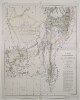
The map shows Mesopotamia and the Turco-Persian frontier with the main rivers and cities. A red line indicates the principal pilgrim route from Hamadan, Persia, to Nejef.1 mapMaterials: Printed on paper.Dimensions: 330 x 200mm.
The map shows the Shatt-ul-Arab [Shatt al-Arab] waterway with the frontier line between Turkey and Persia show in red ink.1 mapMaterials: Printed on paper.Dimensions: 330 x 200mm.
Distinctive Features:Relief shown by hachures and spot heights.Title continues: ‘Zu C. Ritter’s Erdkunde, Buch III, West-Asien, Theil XII. Bearbeitet von H. Kiepert, herausgegeben von C. Ritter. Berlin, 1852 Verlag von Dietrich Reimer’.Map of Hedjaz [Hejaz] province showing various routes including the Hajj pilgrimage, Carsten Niebuhr exploration journey, and J.G. Hulton and Charles J. Cruttenden expedition of 1836.In the bottom right-hand corner there is a table of reference listing Arabic geographic terms with German equivalents and abbreviations.Includes two insets:• plan of Mecca entitled ‘Mekka nach Burckhardt’ drawn to scale 1:30,000 with districts numbered and listed in a table of reference; • map of peninsula and the port of Aden entitled ‘Halbinsel und Hafen von Aden’ drawn to scale 1:200,000 with depths shown by contours.1 mapDimensions:491 x 349 mm, on sheet 584 x 476 mm
Genre/Subject Matter:View of a steamship, ‘British Sailor’, moored alongside a quay at Mina [Mina Salman Port], Bahrain.Inscriptions:Below image, in pen: 'British Sailor at Mina'Below image, in pencil: ‘506’1 b&w silver gelatin printDimensions:54 x 78 mmCondition:The image is in good condition.Foliation:‘506’Process:Silver gelatin print
Genre/Subject Matter:View from the stern of a steamship, ‘British Sailor’, at sail.Inscriptions:Below image, in pen: 'British Sailor'Below image, in pencil: ‘507’1 b&w silver gelatin printDimensions:54 x 78 mmCondition:The image is in good condition.Foliation:‘507’Process:Silver gelatin print
Genre/Subject MatterThis view of Bushire (Bushehr), from an elevated position looking south, is taken from the roof of the offices of Gray, Paul and Co. (sister firm to Gray, MacKenzie and Company), a company that acted as shipping agent for British India steamers between India and Europe, via the Gulf ports.A number of buildings are seen in the photograph, though relative degradation of the image obscures much of the background and horizon area. A building under construction extends from the lower left of the image to the centre. Immediately behind this, the terrace of a flat-roofed building is fenced off. Next to the building under construction, and immediately below the centre of the image, bricks can be seen stacked high against the wall of an adjacent building.In the far right of the image, towards the horizon, a domed roof can clearly be seen amongst the flat-roofed buildings. Although the dome is windowless, a smaller dome with openings to allow light to filter through sits atop it. This is possibly a bath house.InscriptionsLower right, in pencil, alongside image: ‘83’Below image: ‘The Town looking South from Gray. Paul's Office. 23. Feb. 1902’1 photographic printDimensions:109 x 155 mm [landscape]Format:Materials:Condition:The image is considerably faded throughout, with surface losses along the upper edge.Foliation:'83'Process:
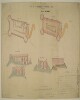
Distinctive Features:Space in the first line of title left blank.Includes ground plan and ‘PLAN OF TERRE PLEIN’ of Ras-Morbat Fort with corresponding longitudinal sections and elevations. Lettered for reference with a key in the bottom right-hand corner. Measurements reported.Inscriptions:On recto, bottom left-hand corner: ‘Isthmus Office July 15th 1846 Drawn by F. Welsh’.‘Copied in the Chief Engrs. Office Bombay 26th September 1846’.On recto, bottom center: ‘/Signed/ J. Kilner Captain Executive Engineer Aden’.On verso, bottom left-hand corner with bleed-through into the recto:‘In Bombay Secret Lre. No. 113 of 1846 Recd. via Southampton 10th Novr. 1846 Aden Fortifications’.1 sheetMaterials:Pen and ink with wash on tracing paperDimensions:695 x 1022 mm
Genre/Subject MatterGeneral view from the outskirts of the town (likely present-day Mutrah) to the harbour and promontory fort, from an elevated position, looking north-northeast. The area of the town and coastline visible in the distant middleground is the part of the town featured in the previous image (Photo 430/8/1). A ship can be seen emerging from behind the promontory right of centre on the horizon near Fort Al-Mirani.While those distant buildings are clearly several-storeyed white-washed buildings, the dwellings in the fore- and middleground are, for the most part, tents and other temporary structures. Overlooking these, on the western ridge a fortified tower can be seen in the far left of the image.A group of figures stands under a single tree in the foreground.InscriptionsUpper right, in pen, on image: ‘p. 3’; alongside image, in pencil: ‘b’Lower right, in pencil, alongside image: ‘2’Below image: 'The Town looking North. 31 Oct. 1900'1 photographic printDimensions:75 x 104 mm [landscape]Format:Materials:Condition:The image is faded throughout with surface losses in the upper left corner. White smeared spot staining in the right hand side of the image and in the lower right-hand corner originate in the printing phase.Foliation:'p 3'; 'b'; '2'Process:
Genre/Subject MatterGeneral view over the town out towards the harbour, from the south-west, looking north-east. Several-storeyed white-washed buildings can be seen in the fore- and middleground. To the far left, two apparently fortified towers can be seen on the foothills of the ridge at left; this is likely to be Fort Al-Mirani.In the bay, two large ships and two smaller boats, possibly dhows, can be seen.InscriptionsUpper right, in pen, on image: ‘p. 1’; alongside image, in pencil: ‘a’Lower right, in pencil, alongside image: ‘1’Below image: 'Town and Bay. 31rst Oct. 1900'1 photographic printDimensions:77 x 100 mm [landscape]Format:Materials:Condition:The image is considerably faded. There are surface losses in the left-hand lower corner and there is surface staining and residue throughout.Considerable fading.Foliation:‘p. 1’; ‘a’; ‘1’Process:
Genre/Subject MatterThis view of the Al-Jalali Fort at the south-eastern end of the Bay of Muscat was likely photographed from the roof of the British Consulate, situated along the shoreline adjacent to it (see also Photo 430/8/3).InscriptionsUpper right, in pen, on image: 'p. 8'; alongside image, in pencil: ‘b’Lower right, in pencil, alongside image: ‘4’Below image: ‘Old Portuguese Fort (1550). 31. Oct. 1900’1 photographic printDimensions:77 x 100 mm [landscape]Format:Materials:Condition:The image is considerably faded throughout. Large white spot staining in the upper left of the image probably originate in the printing phase.Foliation:'p. 8'; 'b'; '4'Process:
Genre/Subject MatterView from the shoreline of the British Consulate at Muscat, looking due west.The consulate is a pale-stoned, two or three-storeyed building built along the quays. Two gas lamps can be seen along the quay in front of the building and a single mashrabiyya (a form of enclosed balcony) breaks up the centre of the facade.Above the consulate a flagpole carries a flag. Figures can be seen sitting on the quay to the far left of the image. Several small boats are tied up along the shoreline.InscriptionsUpper right, in pen, on image: [illegible]; alongside image, in pencil: ‘a’Lower right, in pencil, alongside image: ‘3’Below image: ‘British Consulate. 31. Oct. 1900’1 photographic printDimensions:77 x 102 mm [landscape]Format:Materials:Condition:The image is considerably faded throughout with surface losses along the right-hand edge, lower left corner and 13 mm from left, 40 mm from lower edge. White smeared spot staining in the left-hand side of the image originate in the printing phase.Foliation:'c'; '3'Process:
Genre/Subject MatterThis scene, taken from an elevated position looking southwards towards a bay, shows the village of Sidāb, approximately 3 km south of the Bay of Muscat.A well-trodden path or dried-up stream can be seen leading through the dwellings, the majority of which appear to be tents, in the direction of the shoreline. A few trees and bushes are discernible.InscriptionsUpper right, in pen, alongside image, in pencil: ‘d’Lower right, in pencil, alongside image: ‘6’Below image: ‘Sidap. Village. 31. Oct 1900’Along the left-hand side of the image, white, vertical: [illegible]1 photographic printDimensions:76 x 103 mm [landscape]Format:Materials:Condition:The image is considerably faded in the right of the image.Foliation:'d'; '6'Process:
Genre/Subject MatterThis view of the bay of Muscat from an elevated position in the east was likely photographed from Al-Jalali Fort. It shows the Al-Mirani fort at centre, along with the Sultan's Palace and a variety of other buildings lining the shore in the left middleground.Many small craft are visible in the middleground and foreground, while two boats are at anchor further out in the bay at the right of the image.InscriptionsUpper right, in pen, alongside image, in pencil: ‘c’Lower right, in pencil, alongside image: ‘5’Below image: ‘Sultan's Palace. 31. Oct 1900’1 photographic printDimensions:72 x 100 mm [landscape]Format:Materials:Condition:The image is faded at the left. There are some minor surface losses in the lower half of the image.Foliation:'c'; '5'Process:
Distinctive Features:Relief shown by hachures.Title continues: ‘Zu C. Ritter’s Erdkunde, Buch III, West-Asien, Theil XII, XIII; bearbeitet von H. Kiepert, herausgegeben von C. Ritter. Berlin, 1852 Verlag von D. Reimer’.General map of Arabian Peninsula based on Carl Ritter’s ‘Die Erdkunde im Verhältnis zur Natur und zur Geschichte des Menschen’ [Geography in relationship to nature and to the history of humanity] showing various routes across the region including the Hajj pilgrimage, Captain George Forster Sadlier’s expedition of 1819 and George August Wallin‘s journey of 1848. Provinces and regions labelled with boundary coloured for reference.Includes inset map entitled ‘Oman’ showing Maskat [Muscat] with routes traversed by Pierre-Martin-Rémi Aucher-Eloy and James Raymond Wellsted marked. In the bottom right-hand corner there is a table of reference listing Arabic geographic terms with German equivalents and abbreviations.1 mapDimensions:353 x 475 mm, on sheet 742 x 580 mm
Distinctive Features:Relief shown by hachures.Title continues: ‘Zu C. Ritter’s Erdkunde, Buch III, West-Asien, Theil VIII, IX. Bearbeitet von H. Kiepert, herausgegeben von C. Ritter. Berlin, 1852 Verlag von D. Reimer’.Map of Iran showing territorial extent of the Ottoman, the Russian and the British sphere of influence in the region with borders outlined in colour and explained in a key in the bottom left-hand corner below title. Also shows the boundaries between provinces and various routes across the region.1 mapDimensions:462 x 490 mm, on sheet 478 x 584 mm
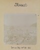
Aerial photograph of a ruined settlement at Ambak [Nibāk], situated in a desert landscape on the frontier between Saudi Arabia and Qatar. The photograph was taken during a Royal Air Force reconnaissance flight on 14 October 1935. On the rear of the photograph is a red date stamp, marked ‘for official use only’, ‘Royal Air Force official, Crown Copyright Reserved’, and dated 16 October 1935.1 black and white photographDimensions:183 x 183 mm.
A map of the Eastern Persian Gulf that was compiled by Commander C G Constable and Lieutenant A W Stiffe in 1860. Corrections made by Commander F H Walter, HMS
Odinand Lieutenant H T Bowen, HMS
Alertin 1910. This version was printed by the Admiralty in 1929. Engraved by J & C Walker.The map has major settlements and relief marked, with water depth shown by soundings. An area of a proposed Royal Navy survey is marked in pink on the map.The map has detailed inserts showing the shore lines of Charak, Kais, Ras al-Khaimah, Hor [Khor] Fakkan, Abu Dhabi and Chiru.1 mapMaterials: Printed on paperDimensions: 1,100mm x 820mm
A map of the Eastern Persian Gulf that was compiled by Commander C G Constable and Lieutenant Arthur William Stiffe in 1860. Corrections made by Commander Frederic H Walter, HMS Odin and Lieutenant H T Bowen, HMS Alert in 1910. This version was printed by the Admiralty in 1934. Engraved by J & C Walker.The maps has major settlements and relief marked, with water depth shown by soundings. An area of a proposed Royal Navy survey is marked in pink on the map.The map has detailed inserts showing the shore lines of Charak, Kais, Ras al-Khaimah, Hor [Khor] Fakkan, Abu Dhabi and Chiru.1 mapMaterials: Printed on paperDimensions: 1,100mm x 820mm
Hydrographic Office map showing the Persian Gulf and Gulf of Oman, with a number of inset maps (including Doha and Abu Dhabi), and views of the coast and islands from the sea. Compiled from surveys by Captain John Michael Guy and Captain George Barnes Brucks, 1821-29, and by Commander Charles Golding Constable and Lieutenant ArthurWilliam Stiffe, 1860, with additions and corrections from surveys by Commander Henry Boyle Townshend Somerville 1903, Commander FH Walter, 1910, Lieutenant HT Bowen, 1910, and Commander Arthur Guy Norris Wyatt, Lieutenant-Commander DH Fryer and Commander A Day, HM Surveying ship
Ormonde, 1930-33.Soundings given in fathoms. Settlements marked, and some indication of relief.Map shows median line (in red); land frontiers and extensions to median line (red dotted line); 20 fathom line (in green); and 10 fathom line (green dotted line). This information is given in a legend at the top centre of the map.No scale given for main map; scale of insets varies.1 mapMaterials: printed on paper.Dimensions: 490 x 640mm, on sheet 520 x 700mm.
A map indicating the location of one buoy in the vicinity of Kishm in the Persian Gulf. The buoy is marked in manuscript on an inset map entitled 'Kishm and Parts Adjacent', with corresponding arrows drawn in the upper and left margins.The base map on which the buoy is indicated is Admiralty chart 2837a, 'Published at the Admiralty 1st. May 1862', 'Small corrections... III-1907'.A hand stamp on the verso reads, 'British India Steam Navigation Co. Ltd. Received 19 Aug. 1908'.1 mapMaterials: Printed on paper with manuscript additions in coloured inkDimensions: 975 x 637mm, on sheet 1023 x 680mm
Admiralty Hydrographic Office chart showing the principal points, islands, and landmarks of the (eastern) Persian Gulf and Gulf of Oman, compiled by Commander C G Constable and Lieutenant Arthur William Stiffe between September 1857 and March 1860, with intervening coast and soundings supplied from the surveys of Captain J M Guy and Captain George Barnes Brucks in 1821-29. Published at the Admiralty in 1862, with small and large corrections to 1899. Engraved by J and C Walker. Inset: Kishm [Qeshm], Kais [Kish], Henjam [Hengām], Charak [Bandar-e Chārak], Abu Thabi [Abu Dhabi], and Khor Fakan [Khawr Fakkān].No scale given for the main map. The scale of the insets varies.Annotated in red crayon to show territory of Trucial Chiefs [Trucial Coast].Inscribed on recto: 'Pol. 716/1900'.Inscribed on verso: 'D42'.1 mapMaterials: printed on paper.Dimensions: 970 x 630mm, on sheet 100 x 660mm.
Admiralty Hydrographic Office chart showing the principal points, islands, and landmarks of the (eastern) Persian Gulf and Gulf of Oman, compiled by Commander C G Constable and Lieutenant Arthur William Stiffe in 1860, with intervening coast and soundings supplied from the surveys of Captain J M Guy and Captain George Barnes Brucks in 1821-29. Published at the Admiralty in 1862, with small and large corrections to 1900. Engraved by J and C Walker. Inset: Kishm [Qeshm], Kais [Kish], Henjam [Hengām], Charak [Bandar-e Chārak], Abu Thabi [Abu Dhabi], and Khor Fakan [Khawr Fakkān].No scale given for the main map. The scale of the insets varies.Marked in red to show approximate limit of pearling ground.1 mapMaterials: Printed on paper.Dimensions: 980 x 650mm on sheet 1080 x 690mm.
Genre/Subject Matter:Informal photograph of children on board the
Arabiaen route to Bombay. Mary Irene Curzon, the eldest daughter of Lord and Lady Curzon, sits at centre in a white bonnet and dress. With her a further three children stand, sit and lie nearby. A woman in white kneels at left, facing away from the camera.In the background a man sitting on a deck chair at centre looks towards the camera. At left in the background another woman sits in a deck chair. At left a woman and man stand (partially cropped out of photograph).This is the first of two, nearly identical photographs taken from the same angle. The second is at Photo 430/75/19.Inscriptions:Ink, below image: ‘Irene on board Arabia Dec 25. 1898’Pencil, alongside image at right: ‘18’Temporal context:This and the photographs that accompany it were taken en route to India at the end of 1898 and during the first year of Lord Curzon’s position as Viceroy of India, 1899.1 b&w albumen printDimensions:94 x 113 mmCondition:The image is buckled along with the card it is mounted upon. Several creases and scratches have been stabilised. Slight underexposure or toning have affected the quality of the print. Light surface dirt throughout.Foliation:'18'Process:Albumen, collodio-chloride and platinum printing out paper
Genre/Subject Matter:Informal photograph of children on board the Arabia
en routeto Bombay. Mary Irene Curzon, the eldest daughter of Lord and Lady Curzon, is at centre in a white bonnet and dress, looking towards the camera. With her a further three children stand, sit and lie nearby. A woman in white kneels at left, facing away from the camera.In the background a man and woman sit nearby one another on deck chairs. Two men walk along the deck at left away from the camera. At left a woman and man stand (partially cropped out of photograph).This is the second of two, nearly identical photographs taken from the same angle. The first is at Photo 430/75/18.Inscriptions:Ink, below image: ‘Irene.’Pencil, alongside image at right: ‘19’Temporal context:This and the photographs that accompany it were taken
en routeto India at the end of 1898 and during the first year of Lord Curzon’s position as Viceroy of India, 1899.1 b&w albumen printDimensions:92 x 118 mmCondition:The image is buckled along with the card it is mounted upon. Several creases and scratches have been stabilised. Slight underexposure or toning have affected the quality of the print. Light surface dirt throughout.Foliation:'19'Process:Albumen, collodio-chloride and platinum printing out paper
Pencil and ink sketch map of the island of Abu Mussa [Abū Mūsá]. The island’s coastline is marked in blue pencil. A number of features on the island are marked and annotated in German, including: an Arabic flag; the locations of two mines; an anchorage and loading point; heaps of red oxide. The map was possibly used in conjunction with a letter, from Shaikh Segger bin Kalet [Ṣaqr bin Khālid Āl Qāsimī] to Hage Hassan bin Ali Somey [Haji Hassan bin Ali Samaiyeh] (translation in the enclosing volume, folios 177-178) containing instructions for the collection of red oxide from Abu Mussa by the steamer
Louise.1 mapDimensions:200 x 285 mm.Materials:Pencil and pen on paper.
Distinctive Features:Relief shown by contours.Tracing showing the oxide iron sites and mines, numbered for reference with explanation in the upper left-hand corner and an annotation ‘Originally favoured by Major Cox with additions by Capt. Moore S/S Gulistan. Abu Musa 19th June 1909’ in the upper right.1 mapMaterials:Pen and ink with additions in blue crayon on tracing paperDimensions:261 x 240 mm
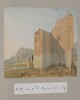
Genre/Subject Matter:This landscape view of a scene near Bushire [Būshehr] shows a trail winding from left through undulating landscape towards a flat plain below. In the background craggy peaks extend from right. Two figures on donkey or horseback can be seen at right while four further figures make their way along the path at left. It is not clear what mirage is being referred to in the title of the drawing.Temporal Context:Although the image dates from the Ouseley embassy 1810–12, the adjacent caption/description likely dates from c. 1880 and was written by later owner of the album, F. G. McCutcheon.Inscriptions:Recto:Lower right corner, in pencil: ‘28’Verso:Upper left, in pencil: ‘Abou-Shehr or Bushire, Persian Gulf’Lower left corner, in pencil: ‘J. D’Arcy. Malvern’Along lower edge, in pencil: ‘On the road to Dalkin [Daliki] from Bushire showing the mirage’Lower right corner, in pencil: ‘Novr. 2 1852’; ‘28’Adjacent inscription: ‘28.On the road from Bushire (Persian Gulf) to Dalkee showing the mirage’1 watercolour drawing on paperDimensions:108 x 282 mmMaterials:Watercolour on paperCondition:Light surface dirt coats the recto and verso, with staining along all edges. Two small puncture holes at upper left and right corners indicate that the drawing was at one time pinned up. A small tear or cut can be seen extending diagonally from lower edge , left of centre, for 10 mm.
The map shows the area of Southern Iraq around Zubair and Basra. The map indicates hydrology (of the Euphrates River), settlements, roads, vegetation and provides some indication of relief.Published by the General Staff India under the direction of Colonel Sir S G Burrard, KCSI, RE, FRS, Surveyor General of India, 1916.1 mapMaterials: Printed on paperDimensions: 460mm x 570mm
Sketch map attached to a report by Bertram Thomas related to the slave trade dated 23 August 1929. Shows Yal Sa'ad country with settlements labelled and boundaries indicated by red dotted lines.1 mapMaterials: Pen and ink on paperDimensions: 210 x 337 mm
This map shows the territory of Kuwait and associated routes topographic heights in feet. The map also shows the location of the Kuwait Oil Company's base of operations, indicated as 'Camp' in the map legend.1 MapMaterials: Bromide on Manuscript with coloured ink.Dimensions: 313 x 353mm
Imprint:Published under the direction of Major-General H.L. Thuillier, C.S.I.-F.R.S., Surveyor General of India, Surveyor General’s Office, Calcutta. December 1877. Photozincographed under the Superintendence of Capt.n. J. Waterhouse.Edition statement:‘Compiled from the most authentic materials available in the Office of the Surveyor General of India, Calcuta, May 1876. With Corrections to November 1877’.Distinctive Features:Relief shown by shading. Boundaries coloured for reference with a key at the bottom left. Routes of various expeditions shown with names of explorers and dates of their journeys given. Notations on topographic features inserted on the map. Shows Telegraph Cable laid in 1864, Indus Valley State Railway, and Sind Punjab and Delhi Railway lines. Includes ‘List of Authorities Consulted in the Compilation of this map’.Inscriptions:In the lower centre above imprint, black faded ink: ‘A.A. 28-10’.1 map on 2 sheetsDimensions:779 x 1050 mm, on sheet 860 x 1108 mm
Genre/Subject Matter:Black and white photograph showing a gravel plain the foreground, and hills in the background.Inscriptions:Upper right, above image, in pen: ‘No 2.’Left, alongside image, in pen: ‘Lofty drifts of loose sand’ and ‘Gravel plain with sand’Right, alongside image, in pen: ‘Hills partially covered by sand drifts’Centre, below image, in pen: ‘Rocky ground. View to N. of Manzil’.1 photographDimensions: 105 x 149mm
Genre/Subject Matter:This lithographic print shows objects and utensils in common use in Mecca. The items are drawn from the collection of Christiaan Snouck Hugronje and the illustration was printed by Pieter Willem Marinus Trap, the lithographic printer of the journal
Internationales Archiv für Ethnographie.The objects are itemised in the list of plates at the beginning of the volume. Each object is identified by a number, which refers to elements in this list. The information in square brackets has been taken from a contemporaneous essay by Snouck Hurgronje entitled ‘Ethnographisches aus Mekka’, which was published in
Internationales Archiv für Ethnographie, Vol. I, Leiden, 1888.They are as follows:1
Zèmbil(Marktkörbchen) [Market basket. Zigzag-shaped wickerwork palm leaf strips with two handles opposite one another at the centre of the edge, which is secured with braided black wool. These baskets are to be found in various sizes, the larger ones usually have a flat base.]2
Mèknasah(Teppichbesen aus Palmblättern) [Carpet brush; this two-sided bristles of palm leaf are bent towards each other and bound together so that the bristles the brush and the middle-ribbing form the handle.]3
Mekkabbah(Deckel für Schüsseln oder teller, die, mit Speisen gefüllt, von Haus zu Haus oder in die Moschee getragen warden) [Hat-shaped cover. The spiralling wicker-work of palm leaf strips are braided over a thin hoop. Strips of different coloured wool are drawn through the wickerwork near the edge of to form a fringe-like embellishment. In addition, short, narrow strips of silk and wool are affixed by sewing them on near the edge. ‘Would be used to cover a bowl or metal plate when one wants to send such a vessel, filled with food, to friends or neighbours, for example because one cannot accept an invitation to dinner.’]4
Quffah(Körbchen zum Mitnehmen von Speisen) [Cylinder-shaped basket with a covering lid that is attached by means of a cord threaded through two opposite points. Zigzag-shaped wickerwork of palm leaf strips into which short tassels of variously-coloured wool are worked in as embellishment. Children take such baskets of food to school. They also serve to carry dates, bread and the like, which are taken to mosques by the faithful for evening worship during the fasting month to enjoy after sunset as the first refreshment.]5, 5a
Mèrwaẖaj(aus Palmblättstreifen geflochtener Fächer) [Four-sided fan; zigzag-shaped wickerwork of narrow palm leaf strips. As a handle the stem of a palm leaf. The embellishments are formed of squares of numerous, convening holes, irregular six or four-sided in shape.]6
Qubqāb(hölzerner Stelzschuh, in dieser Form von Weibern getragen) [Wooden sandal with flower-deocration in red, yellow and silver and a row of bisected yellow diamonds along the central axis, on a green background. This form of shoe is worn primarily by women, un-coloured
Qubqābsare made use of by both sexes in the bathroom (and privy); because going barefoot is not recommended but leather footwear would be damaged by the running water.]7
Madāsmèkkāwi(mekkanische Sandale) [Mekkan Sandal, the upper side is decorated by rows of gold and silver thread tracery in rows across the transverse strap and yellow, red and green leather straps. Tiny green leather strips wind around the upper end of the peg that rests between the toes. Flaps of black, green, reddish and yellowish wool are attached to the middle of a second, adjacent strap. The name is only used by convention; no less frequently is the
Madāsmèdèniworn. Perhaps the origin of the form survives in the name.]8
Madāsmèdèni(medinensische Sandale; nicht weniger als die vorhergehende Form in Mekka getragen) [Medina Sandal. Almost identical to the previous, except with only one transverse strap with half-heart shaped flaps of variously-coloured wool fabric at the middle of the upper side. The leather peg is [decorated] as in the previous type. The inner part of the upper side of the sole is sewn with golden strips at the front edge. As to the meaning of the name, see above.]9, 10
Kursī’s(Tischchen zum Daraufstellen grosser metallener Teller mit Speisen) [Octagonal table: at each corner the table top meets one of the columnar legs of the table. Below the table top column-like bars at an angle as well as knobs form a grill. Lengths of semi-oval slat are attached to the table top itself, along each edge. The legs, the latticework and the slats are painted in various bright colours, the brown-wooden sheet is unpainted. A large metal plate is places onto such a table; food (e.g. rice with meat) is either directly placed onto it, or in various dishes. Such tables serve also serve to display beautiful copper objects (e.g. cans, Jassen) as showpieces.Rectangular table: a portion of the upper end of the four pillar-shaped legs are painted in various bright colours (marbled), the grill consists simply of vertical columns. Otherwise, apart from in form, identical with the above.]11, 12
Raẖl’s(Lesepulte, resp. aus Holz und aus Palmblattstielen; vorzüglich zu Uebungen im Qurānrecitieren gebraucht) [Lectern of brown wood; both the feet and the desk are formed of a piece each, which are movable due to the hinge at the mid-point of their length. The feet are carved up-to-date, the outer sides of the lectern with carving in base-relief. Used namely by boys learning to recite the Qur’an. Lectern made of palm leaf stalks; the crossbars are inserted through holes in the long bars.]13
Qalaç(lederne Mäklertasche zum Aufnehmen kleiner, dem Dèllāl zum Verkauf übergebener Gegenstände) [Leather trader’s bag. The exterior is decorated with many leather strips, which are brought together to form tassels and cords, and are decorated with strung beads of white metal. At the upper edge of the bag, six leather loops, through which a belt passes, by means of which the bag is closed. In actual fact, for the dealer, who is connected with practically every type of sale, such a bag serves to store small items (jewellery etc.) entrusted to the trader to sell; even when the bag is empty, the trader wears the bag over his shoulder, as a sort of attribute of his trade.]Inscriptions:Printed above image, in ink:XXXVIIIPrinted beneath image, in ink:Lower right corner: ‘ex. coll. auct.’Lower left corner: ‘P.W.M. Trap exc.’1 lithographic printDimensions:250 x 200 mmFormat:1 lithographic printCondition:The print is in good condition.Foliation:‘XXXVIII’
Genre/Subject Matter:This lithographic print shows objects and utensils in common use in Mecca. The items are drawn from the collection of Christiaan Snouck Hugronje and the illustration was printed by Pieter Willem Marinus Trap, the lithographic printer of the journal
Internationales Archiv für Ethnographie.The objects are itemised in the list of plates at the beginning of the volume. Each object is identified by a number, which refers to elements in this list. The information in square brackets has been taken from a contemporaneous essay by Snouck Hurgronje entitled ‘Ethnographisches aus Mekka’, which was published in
Internationales Archiv für Ethnographie, Vol. I, Leiden, 1888.They are as follows:1, 2
Schèrbah’s(hölzerne Wasserkrüge) [Wooden, vase-shaped pitcher with lid. The outside is painted in bright colours; the individual colour-bands are interspersed with decorative bands of yellow. The the majority of the decoration is formed by removing the varnish in the form of the intended design, forming a kind of incised decoration. The wide neck is painted green. As regards use, [cf. 1781.b.6/72] the same use for the wooden as for the clay pitchers apples. Note: the wood is actually more than decorative; for that very reason, because they do not cool the water, they are less useful. [Example 2:] Similar to the previous. The bell is larger the inner side of the neck painted red. The decorated is produced in the same way.]3, 4
Barrādijjeh’s(hölzerne Wasserkrüge) [Wooden water pitcher, only slightly narrowing from base to lid, with a very gentle contraction beneath the rim of the opening. Inside the neck a sieve-like sheet in the centre of which a large six-pointed star is cut out. The lid finds its centre in a tall knob, from whose tip and in a ring thereabouts wooden beads are attached to helical springs. Decoration is as in the previous. [Example 4:] Similar to the previous. On the inside of the neck there is a sieve-like punctuated wooden disc attached. Wooden objects such as this are beginning to be discussed, and similarly painted items have been received by the Ethnographic Imperial Museum from Calcutta. The decorations, however, are not incised but rather painted with colours. Extending from the edges, with partly round, partly star-shaped holes. The upper side of the sieve and the inner part of the neck that lies over it are painted red, as well as the concave underside of the lid.]5
H̱uqq(hölzerne Dose zur Aufbewahrung kleiner Gegenstände) [Wooden box with lid whose lower edge is wider than walls of the box. The interior of the boc and the lid are painted a dirty light green. For the safekeeping of small objects of various kinds.]6
Kāsoder
Kāsah(Trinkbecher) [Wooden drinking cup with tapering wall, from top to bottom. Base and inner side red, the external sides various colours, with metallic reflex. Used for drinking water or Sherbet. ]7
H̱uqq(hölzerne Dose) [Spherical box with colourful marbled markings, which are distributed thoughout fields between red and purple coloured bands, which run across the sphere. Although the centre of the belt, a bat-shaped decoration, produced by the scraping away of a portion of the paint. The box opens in the middle.8
Qaçabah(hölzernes Gestell zur Aufnahme eines Wasserkruges) [Wooden frame, used for holding a water pitcher. Between three, diagonally tapering, pillar-like legs, which narrow towards one another at the top, at the base a wooden lattice-work consisting of small knobs and buttons attached between parallel crossbars. Wooden acorns hang from the lower crossbars. On the inner side of the lattice-work a wooden ball is formed, into which a pitcher would rest, when placed there. The upper ends of the legs are attached into holes in the clay underside of the barrel-shaped head, which, at the top, forms into a vase-shape. On the lower edge of the head, are six wooden knobs. Between each pair of legs is a pillar-shaped rod with knob-like protrusions to the right and left of the middle of its length, and with a wooden acorn hanging from the lower end. In the middle of the upper end of the head is an iron eyelet onto which an iron ring and iron hook are attached, by which means the rack is hung onto the wall of a room. Painting etc. can be seen in the illustration. Racks that serve the same purpose, called
mirfa’are placed on the ground and are usually four-footed.]Inscriptions:Printed above image, in ink:XXXIXPrinted beneath image, in ink:Lower right corner: ‘ex. coll. auct.’Lower left corner: ‘P.W.M. Trap exc.’1 lithographic printDimensions:250 x 198 mmFormat:1 lithographic printCondition:The print is in good condition.Foliation:‘XXXIX’
Genre/Subject Matter:This lithographic print shows objects and utensils in common use in Mecca. The items are drawn from the collection of Christiaan Snouck Hugronje and the illustration was printed by Pieter Willem Marinus Trap, the lithographic printer of the journal
Internationales Archiv für Ethnographie.The objects are itemised in the list of plates at the beginning of the volume. Each object is identified by a number, which refers to elements in this list. The information in square brackets has been taken from a contemporaneous essay by Snouck Hurgronje entitled ‘Ethnographisches aus Mekka’, which was published in
Internationales Archiv für Ethnographie, Vol. I, Leiden, 1888.They are as follows:1
Schèrbah(hölzerner Wasserkrug) [Wooden water pitcher, vase-shaped; the interior of the neck opening red.]2
Rub’ī(hölzerner Wasserkrug) [Wooden water pitcher, vase-shaped; with narrow neck that is less than half as narrow as the above and the interior is red. Bell with metallic reflex.]3
Mèschrab(hölzerner Becher mit Untersatz und Deckel) [Wooden vessel with stand and lid. Interior of the lid and the bowl, as well as the underside of the base painted red. Exterior green marbled. Decoration incised by the same method described previously [cf. 1781.b.6/74]. Used for drinking Sherbet.]4
H̱uqq(Dose mit Deckel) [Wooden box with lid, whose lower edge protrudes over the walls of the box. The interior of the box and lid are painted a dirty light green. Used for keeping small objects of different kinds.]5
Ṯasahoder
Mèschrab(hölzerne Trinkschale) [Wooden drinking cup. Inner side light gray green, the border coloured yellow. Exterior bluw with yellow decorations as described previously [cf. 1781.b.6/74] and two red bands.]6, 7
Findjānund
Ẕarf(hölzerne Kaffeetasse und becherförmige, dazu gehörende Untertasse) [
Findjān: Bedouin coffee saucer. Of yellowish clay with greenish glaze. Similar vessels larger in size serve as butter dishes.
Ẕarf: Coffee cup, light brown wooden saucer, for holding a coffee cup [7] of the same material. The exterior of each well polished.]8
Kātah(kleiner Becher mit Deckel) [Cup with lid of brown, polished wood in the form of a flass. The edges of the cup are edged by a narrow yellow-line. The material is thought to be Aloe wood.]9
Mèschrab(messingene Trinkschüssel; in der Mitte einer Art Pfeiler, von dessen Rande einige messingene Amulete herabhängen) [Brass bowl. From the centre a kind of column rises so that a second, smaller bowl rotates, on the edge of which many small bits of brass (amnulets) hang down. On the inner side of the bowl are engraved characters. Similar in form, (without the amulets) are the cups from which one may drink Zemzem water at the mosque.]10
Schīschah(Wasserpfeife) [Waterpipe consisting of a brass tripod onto which a coconut rests, from which a brass-studded pipe leans out to one side and serves to receive the hose. The coconut is mounted with brass at both ends; the lower end is an upturned cone-shaped tip with a thick knob at the end. With this the pipe rests onto the footpiece. The upper part of the brass coconut, which is connected to the lower part by vertical strips of brass that extend over the wooden, brass-studded tube, out of whose upper end the black,-glazed earthenware head of the pipe is inserted. The hose is made of leather, over which thin copper wire is woven and then covered with wood. To connect the pipe a black, painted wooden tube is secured at one end while the other holds the wooden, mouthpiece.]11 Elf Amulete aus vergoldetem Silbera vier (buchförmige)
Chatmah’szur Aufnahme von Qurānsprüchen usw.b zwei
Heikal’sc zwei
Lōẖ’smit Sprüchene ein
Ischm, zur Aufnahme eines Edelsteines[Eleven silver plated amulets on a silver-gilt chain, wherein eyelets are to be found on the upper edge while small bells hang. There are four instances of two identical shapes, so that in total seven different forms are represented as follows:a four in the in the form of a book with a cover (
Chatmah), actually intended to reveal quotations from the Qur’anb two in roll-form with rounded ends, one of which with a coverc two shield-shaped, one side almost entirely covered with charactersd two half-moons, also covered with characterse an oval container (
Ischm), surely intended to carry gemstonesSuch chains with amulets are usually worn by children, especially during holidays.]12
Subẖah(Rosenkranz aus Perlmutter) [Prayer beads with 100 pea-sized beads of mother of pearl, strung on a silken cord. The division of 2 x 33 and 1 x 34 pearls is achieved by inserting forward-projecting, elongated four-sided pieces of mother of pearl (
imām). At the lower end the handle, a columnar peace of mother of pearl.]Inscriptions:Printed above image, in ink:XLPrinted beneath image, in ink:Lower right corner: ‘ex. coll. auct.’Lower left corner: ‘P.W.M. Trap exc.’1 lithographic printDimensions:250 x 198 mmFormat:1 lithographic printCondition:The print is in good condition.Foliation:‘XL’
Genre/Subject Matter:This lithographic print shows objects and utensils in common use in Mecca. The items are drawn from the collection of Christiaan Snouck Hugronje and the illustration was printed by Pieter Willem Marinus Trap, the lithographic printer of the journal
Internationales Archiv für Ethnographie.The objects are itemised in the list of plates at the beginning of the volume. Each object is identified by a number, which refers to elements in this list. The information in square brackets has been taken from a contemporaneous essay by Snouck Hurgronje entitled ‘Ethnographisches aus Mekka’, which was published in
Internationales Archiv für Ethnographie, Vol. I, Leiden, 1888.They are as follows:1
Ghèllājah(Wasserkrug) [Water pitcher. Made of grey, porous clay with handle and spout; wooden lid. The decoration consists of teeth-like elevations and incised dashes. The vessel is filled from a large, clay barrel, which contains the water reserved for household needs, so that an amount of cool drinking water is always available. From this vessel one pours the water into smaller pitchers and from the latter into drinking vessels. Instead of lids, one probably places a thin white cloth, for the purpose of filtering the poured water.]2
Dōraq(Krug für Zemzemwasser) [Pitcher for Zemzemwater, made of ‘grey porous clay’, with handle. ‘In the mouth of the jug is a plug made of tree fibres, the same type used as a sponge with which to wash the body; here the material is used to filter the holy water. Hundreds of full
Dauraqsare to be found around the mosque and those who serve the Zemzem water pour the water from such pitchers for their customers.’]3, 5, 6
Schèrbah’s(Wasserkrüge) [Vase-shaped pitcher with earthenware cover. Apart from its use as a water pitcher, this vessel is used especially during the months of Ramadan in mosques at the end of a period of fasting. It is also placed before visitors to the mosque alongside a jug of Zemzem water and contains chilled water, into which fruits, especially Mulberries, are placed, so that the water tastes the same.]4
Ibrīq(Wasserkanne für Ablutionen) [Made of grey, porous clay. Ribs around the bell. Handle and spout. The
Ibrīqis filled with water and used for the purpose of ritual washing and cleaning after performing natural needs. The
Ibrīqis sometimes also made used for washing the hands after eating, for which most often a copper
Ibrīqand bowl are used.]7
Qullah(Wasserkrug) [Vase-shaped water-pitcher. Made of similar material to the
Ibrīq(grey, porous clay), decoration similar to that found on the
Ghèllājah; also, on the neck and on the upper half of the walls of the bell, oblique and vertical deep incisions. Wooden lid.]8
Rub’ī(Wasserkrug ; die Form gilt als specifisch mekkanisch) [Vase-shaped water-pitcher with two opposing handles at the junction between the neck and the bell. Wooden lid, which ends in a long, round spigot that fits into the neck of the pitcher.]9
Kānūn(Kohlenfass aus Thon; dient als tragbarer Ofen) [Coal-barrel, made from red clay on three, even legs, that join at a bowl-shaped, round foot. The exterior is painted in various colours but not glazed. The shape on the whole is irregular. These and similar vessels serves as portable stoves for cooking food outside the actual kitchen, where brick kilns are used.]10
Mènqèl(irdenes Becken zum Vorbrennen von wohlriechendem Holz) [Cup-shaped, earthenware basins. The round base is hollowed out from below, the sides painted in different colours, though not glazed. Used for burning grafrant wood, such as aloe or for smoking the
Qafalthat is used for drinking water; one holds the empty drinking jug upside over it before filling. Clothes or even the whole body can be smoked over it.]11, 12
Schèrbah’s(Kaffeekrüge der Beduinen) [Bedouin coffee pitcher. With a wide base, high, narrow neck and handle. Material: reddish clay, coloured on the outside reddish-brown, though not glazed with ornamentation in blackish grey-brown colour. Neck-opening with spout.]13
Findjān(Kafeenäpfchen der Beduinen) [Bedouin coffee saucer. Of yellowish clay with greenish glaze. Similar vessels larger in size serve as butter dishes.]14, 15
Muschṯẖaqqèr-
ridjālund
M. ẖaqq el-ẖarīm(Männer- und Frauenkamm) [Man’s comb. The top edge with transverse grooves. The material is sold under the name of ‘sandalwood’. Woman’s comb. On each side there is a hole for the fingers. Grooved pattern along the middle of the comb. The material is sold as aloe wood, but is usually only perfumed.]16
Medakk(hölzernes Einziehestäbchen, womit die
Dikkehin die Koulisse der Beinkleider gebracht wird) [Wooden feeding-stick. Painted in bright colours with a hole at the upper end. The ‘
Dikkèh’ (the [waist-]band with which the trousers are pulled together at the middle of the body and fastened) is threaded through this hole and in this way the ‘
Dikkèh’ is in turn threaded into the
Koulisse(Bêt èd-dikkèh) or sliding seam.]17
Mibcharah(Weihrauchbecken) [Made from brass with a lid, which pivots from a hinge on the handle itself. The lid has six round holes. The base is hollowed out. Such vessels with burning incense are held up for the departing guests with which to smoke the hands upon bidding farewell. ]18
Merassch(Vase zum Besprengen mit Rosenwasser) [Vase made of frosted glass (Bohemian in style) with long, thin neck and decorated with gold. In the mouth of the vase is a glass pipe which is secured by means of a screw thread. Used for sprinkling departing guests with rosewater.]19
Qèdaẖ(hölzerne Trinkschale) [Drinking bowl of brown wood. Decoration consists of pins of soft, white metal driven into [the outside]. Near to the edge a row of brass pins with large, round heads, such as those found in the centre of the base on the inside. Meccans drink out of such bowls often, in so far as they don’t pay homage to the ‘new style’ of glass dishes.]The number ‘19’ appears erroneously adjacent to two of the objects, at right and left, while ‘9’ is omitted. A note at the foot of the itemised list of plates explains that the ‘19’ on the left is an error and should refer to number ‘9’.Inscriptions:Printed above image, in ink:XXXVIIPrinted beneath image, in ink:Lower right corner: ‘ex. coll. auct.’Lower left corner: ‘P.W.M. Trap exc.’1 lithographic printDimensions:250 x 200 mmFormat:1 lithographic printCondition:The print is in good condition.Foliation:‘XXXVII’
The sheet contains a section map: Isfahān—Urūjān [Borūjen]—Ardal—Gurāb—Bāzuft—Chilau in Bakhtiāri Country, south-western Persia. It is found in the
Military Report on S. W. Persia, Vol. III. Bakhtiāri Country North of Kārūn Rivercompiled in the Division of the Chief of the Staff, Army Head Quarters, India. It show a cross-sectional view of the route.The map includes a printing statement which reads 'I. B. Topo. Dy. No 8,170. Exd. C. J. A., July 1909. No. 4,907-I., 1909.'.Vertical scale: 1:72,0001 mapMaterials: Printed on paperDimensions: 210 x 639mm