par E. Andriveau ; gravé le trait et les montagnes par Gérin, les écritures par P. Rousset, les eaux par Mme Fontaine.Covers portions of Israel, Jordan, Syria and Lebanon.Relief shown by hachures. Depth shown by sounding and isolines.Insets: [Sinai] (Scale [ca. 1:2,600,000]) -- Golfe de Suez -- [Cross section of the Palestine from the source of the Jordan to the Red Sea] -- [Panoramic view of the mountains of Palestine] -- Jérusalem d'après le plan de G. Williams (Scale [ca. 1:80,000])."No. 18"."Atlas usuel No. 23"."Atlas universel No.36".Includes notes and index.In French with place names in Latin, Arabic and Hebrew in Latin script.Electronic reproduction. Cambridge, Mass. : Harvard Geospatial Library, 2009. Georeferenced image for use in a GIS.
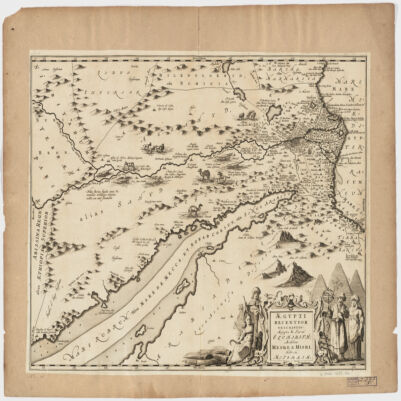
Covers Egypt and portions of Libya, Israel and Jordan, including the Red Sea and the Nile.Relief shown pictorially.Oriented with North to the right.Includes ill.Appears in: Nieuwen atlas ofte werelt-beschrijvinge vertoonende de voornaemste rijckenende landen des gheheelen aerdt-bodems; vermeerdert met veel schoone landt-kaerten, nieuwelijcks uptgegeven (...) / Ioannem Iansonium, 1657-87. Vol. 3, map No. 96.In Latin with place names in Hebrew and Arabic in Latin script.