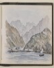
Genre/Subject Matter:This landscape view of the coastline along the Red Sea was sketched from on board ship. Horeb and Sinai here refer to the mountains – often considered one in the same: Mount Sinai – mentioned in the bible. The scene is rendered in watercolour.Inscriptions:Verso of previous folio, in ink: 'Red Sea, looking (6 a.m.) towards Horeb & Sinai ~ 6th Janr 1880’Recto, in pencil, upper right corner: ‘28’1 watercolour drawing on watercolour paper, bound into volumeDimensions:139 x 228 mmMaterials:Watercolour on watercolour paperCondition:Light surface dirt coats the recto and verso, with staining in particular along the fore-edge and small stains in sky area.
Distinctive Features:Watercolour, pen and ink and pencil on paper.The sketch drawn by Lieutenant Michael Houghton shows two sequential topographical views of the coastal region at the Ul Umrah [Jazīrah al Ḩamrā’, United Arab Emirates].The views were sketched from on board ship and show a landmark inscribed: ‘Ras Bohamed’ and the town of Ul Umrah with latitude reported. The upper view features several dhows.1 watercolour viewMaterials: Pen and ink with wash on paperDimensions: 55 x 29 mm or smaller
Distinctive Features:Watercolour, pen and ink and pencil on paper.The sketch drawn by Lieutenant Michael Houghton shows two sequential topographical views of the coastal region between Bookh [Bukhā, Oman] and ‘Shaum’ [Sha’am, Oman]The views were sketched from on board ship and show landmarks inscribed: ‘Jeddee’[Al Jādī, Oman], ‘White Patch’, ‘Shaum’ and ‘Mosque on a Mount’ with latitude reported. The bottom view also features a ship.1 watercolour viewMaterials: Pen and ink with wash on paperDimensions: 80 x 340 mm or smaller
Distinctive Features:Watercolour, pen and ink and pencil on paper.The sketch drawn by Lieutenant Michael Houghton shows two sequential topographical views of the coastal region between Raumps [Al Rams, United Arab Emirates] and Ras-al-Khyma [Ra's al-Khaymah, United Arab Emirates].The views were sketched from on board ship and show several dhows and ‘Raumps’ settlement with latitude reported.1 watercolour viewMaterials: Pen and ink with wash on paperDimensions: 80 x 341 mm or smaller
Distinctive Features:Watercolour, pen and ink and pencil on paper.The sketch drawn by Lieutenant Michael Houghton shows three sequential topographical views of the coastal region at the Ras Moosendem [Ra’s Musandam, Oman].The views were sketched from on board ship and show landmarks inscribed: ‘Jezeerat Gunnum’ [Jezirat al Ghanam] and ‘Southern Entrance to Discovery Strait’ [Khor Quwai, Oman], also features several dhows and an anchored ship.1 watercolour viewMaterials: Pen and ink with wash on paperDimensions: 80 x 350 mm or smaller
Distinctive Features:Watercolour, pen and ink and pencil on paper.The sketch drawn by Lieutenant Michael Houghton shows three sequential topographical views of the coastal region at the Ras Moosendem [Ra’s Musandam, Oman]. The views were sketched from on board ship and show landmarks inscribed: ‘Ras Sheik Munsoud’ [Ras Shaikh Mas’ud, Oman], ‘Cape Jeddee’, ‘Jeddee Village' [Al Jādī, Oman], ‘Bookh’ [Bukhā, Oman] and ‘Shaum Pt.’ [Sha’am, Oman] with latitude reported.1 watercolour viewMaterials: Pen and ink with wash on paperDimensions: 60 x 338 mm or smaller
Distinctive Features:Watercolour, pen and ink and pencil on paper.The sketch drawn by Lieutenant Michael Houghton showing the coastal topography of the Musseldom Island [Jazīrat Musandam, Oman] from the west.The view was sketched from on board ship and shows four rocky islands inscribed: ‘Great Quoin’, ‘Small Quoin’, ‘Lump I[slan]d’ and ‘Musseldom Island’ with latitude reported.1 watercolour viewMaterials: Pen and ink with wash on paperDimensions: 55 x 341 mm or smaller
Genre/Subject Matter:This landscape view at Suez shows a settlement located along a body of water that is either the canal or the Gulf of Suez. A large area of stony, hillocky ground takes up most of the foreground aside from a lone pole and post located in the lower right corner of the scene.The scene is rendered in watercolour.Inscriptions:Verso of previous folio, in ink: 'Suez, 7th January, 1880~’Recto, in pencil, upper right corner: ‘29’1 watercolour drawing on watercolour paper, bound into volumeDimensions:139 x 228 mmMaterials:Watercolour on watercolour paperCondition:Light surface dirt coats the recto and verso, with staining in particular along the fore-edge and verso.
Distinctive Features:Watercolour, pen and ink and pencil on paper.The sketch drawn by Lieutenant Michael Houghton shows a topographical view of the coastal region at the Sharga [Sharjah, United Arab Emirates].The view was sketched from on board ship and shows the town of Sharga with the location of ‘Tower at Sharga’ indicated and landmarks inscribed: ‘Fusht’ and ‘High Mound’; latitude reported. The view features several dhows.1 watercolour viewMaterials: Pen and ink with wash on paperDimensions: 40 x 580 mm
Distinctive Features:Watercolour, pen and ink and pencil on paper.The sketch drawn by Lieutenant Michael Houghton shows two sequential topographical views of the coastal region at the Ras Moosendem [Ra’s Musandam, Oman]. The views were sketched from on board ship and show the northern entrance to Discovery Strait [Khor Quwai, Oman] featuring a sailing vessel.1 watercolour viewMaterials: Pen and ink with wash on paperDimensions: 70 x 350 mm or smaller
Distinctive Features:Watercolour, pen and ink and pencil on paper.The coastal view drawn by Lieutenant Michael Houghton from a sketch by Dr A. Mackell showing topography of the Jirnain Island [Qarnayn, United Arab Emirates]. The view was sketched from on board ship and shows the profile of Jirnain Island from the west. Along the horizon from the left to right of the image craggy peaks give way to flatter-topped range extending down and out to the sea. In the background on the left of the image a ship appears in the far distance.1 watercolour viewMaterials: Pen and ink with wash on paperDimensions: 80 x 580 mm
Distinctive Features:Watercolour, pen and ink and pencil on paper.The coastal view drawn by Lieutenant Michael Houghton from a sketch by Dr A. Mackell showing topography of the Zircooa Island [Zirkūh, United Arab Emirates]. The view was sketched from on board ship and shows the profile of Zircooa Island from the east with latitude reported.1 watercolour viewMaterials: Pen and ink with wash on paperDimensions: 66 x 582 mm