by Mounsieur Sanson ; rendred into English and illustrated by Richard Blome ; Francis Lamb Sculpit.Covers also portions of Spain, Sicily, Greece, Crete, Turkey and Cyprus.Relief shown pictorially.Includes ill. and index.In English, translated from French.
by Mounsieur Sanson ; rendred into English and illustrated by Richard Blome ; Francis Lamb Sculpit.Covers also portions of Spain, Sicily, Greece, Crete, Turkey and Cyprus.Relief shown pictorially.Includes ill. and index.In English, translated from French.
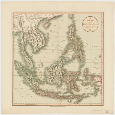
by John Cary.Relief shown pictorially and with shading.Prime meridian: Greenwich.Covers Sumatra, Java, Borneo, Sulawesi, the Philippines, Papua new Guinea and portions of China, Burma and Malaysia.Shows boundaries, rivers, roads and settlements.Electronic reproduction. Cambridge, Mass. : Harvard Geospatial Library, 2009. Georeferenced image for use in a GIS.Electronic reproduction. Cambridge, Mass. : Harvard College Library Digital Imaging Group, 2009. (Open Collections Program at Harvard University. Islamic Heritage Project). Copy digitized: Map Coll (Pusey) : MAP-LC G8000 1801 .C3.
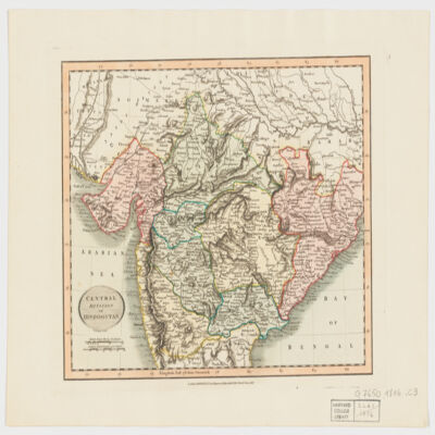
by John Cary.Covers Central and Northern India.Relief shown by hachures.Electronic reproduction. Cambridge, Mass. : Harvard Geospatial Library, 2009. Georeferenced image for use in a GIS.
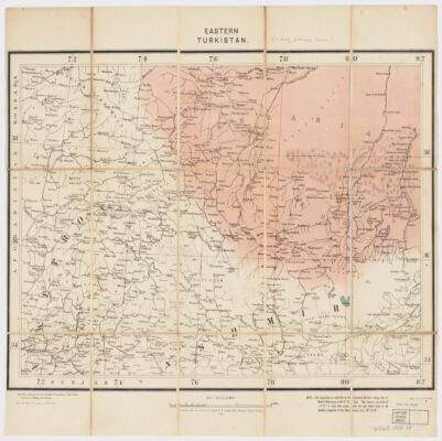
specially prepared for the Foreign Department, from India ; published under direction of Colonel F. B. Longe, R. E., Surveyor General of India.Covers Xinjiang (also known as Chinese Turkestan or Uyghuristan) and portions of Russian Turkestan, Pakistan and India.Relief shown by spot heights.Includes a note : "The Longitudes are referrible to the Greenwich Meridian, taking that of Madras Observatory as 80°-17'-21'' East. They require a correction of --2'-27'' to make them with the most recent value of the Geodetic Longitude of that Observatory, uiz, 80°-14'-54''.""Litho., S.I.O., Calcutta."Electronic reproduction. Cambridge, Mass. : Harvard College Library Digital Imaging Group, 2009. (Open Collections Program at Harvard University. Islamic Heritage Project). Copy digitized: Map Coll (Pusey) : MAP-LC G7405 1908 .S8.Electronic reproduction. Cambridge, Mass. : Harvard Geospatial Library, 2014. Georeferenced image for use in a GIS.
by John Cary.Covers Northeast India, Bangladesh and Nepal.Relief shown by hachures.Electronic reproduction. Cambridge, Mass. : Harvard College Library Digital Imaging Group, 2009. (Open Collections Program at Harvard University. Islamic Heritage Project). Copy digitized: Map Coll (Pusey) : MAP-LC G7652.I5 1816 .C3.Electronic reproduction. Cambridge, Mass. : Harvard Geospatial Library, 2009. Georeferenced image for use in a GIS.
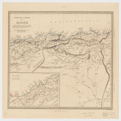
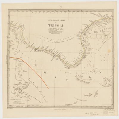
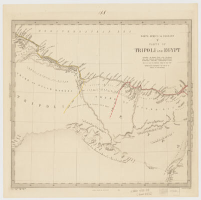
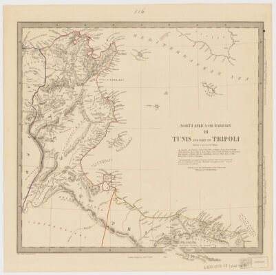
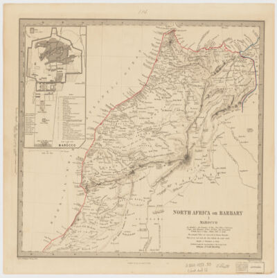
Society for the Diffusion of Useful Knowledge ; engraved by J. & C. Walker.Relief shown by hachures.Colored in outline.Marocco sheet includes Inset: Plan of the city of Marocco (Scale [ca. 1:32,000]) and Algier sheet includes inset Continuation of Algier (Scale [ca. 1:2,000,000]).Some sheets with sources in lower margin.Table of Contents: I. Marocco (Scale [ca. 1:2,800,000]) -- II. Algier (Scale [ca. 1:2,000,000]) -- III. Tunis and part of Tripoli (Scale [ca. 1:2,000,000]) -- IV. Tripoli (Scale [ca. 1:2,000,000]) -- V. Parts of Tripoli and Egypt (Scale [ca. 1:2,000,000]).
Society for the Diffusion of Useful Knowledge ; engraved by J. & C. Walker.Relief shown by hachures.Colored in outline.Marocco sheet includes Inset: Plan of the city of Marocco (Scale [ca. 1:32,000]) and Algier sheet includes inset Continuation of Algier (Scale [ca. 1:2,000,000]).Some sheets with sources in lower margin.Table of Contents: I. Marocco (Scale [ca. 1:2,800,000]) -- II. Algier (Scale [ca. 1:2,000,000]) -- III. Tunis and part of Tripoli (Scale [ca. 1:2,000,000]) -- IV. Tripoli (Scale [ca. 1:2,000,000]) -- V. Parts of Tripoli and Egypt (Scale [ca. 1:2,000,000]).
Society for the Diffusion of Useful Knowledge ; engraved by J. & C. Walker.Relief shown by hachures.Colored in outline.Marocco sheet includes Inset: Plan of the city of Marocco (Scale [ca. 1:32,000]) and Algier sheet includes inset Continuation of Algier (Scale [ca. 1:2,000,000]).Some sheets with sources in lower margin.Table of Contents: I. Marocco (Scale [ca. 1:2,800,000]) -- II. Algier (Scale [ca. 1:2,000,000]) -- III. Tunis and part of Tripoli (Scale [ca. 1:2,000,000]) -- IV. Tripoli (Scale [ca. 1:2,000,000]) -- V. Parts of Tripoli and Egypt (Scale [ca. 1:2,000,000]).
Society for the Diffusion of Useful Knowledge ; engraved by J. & C. Walker.Relief shown by hachures.Colored in outline.Marocco sheet includes Inset: Plan of the city of Marocco (Scale [ca. 1:32,000]) and Algier sheet includes inset Continuation of Algier (Scale [ca. 1:2,000,000]).Some sheets with sources in lower margin.Table of Contents: I. Marocco (Scale [ca. 1:2,800,000]) -- II. Algier (Scale [ca. 1:2,000,000]) -- III. Tunis and part of Tripoli (Scale [ca. 1:2,000,000]) -- IV. Tripoli (Scale [ca. 1:2,000,000]) -- V. Parts of Tripoli and Egypt (Scale [ca. 1:2,000,000]).
Society for the Diffusion of Useful Knowledge ; engraved by J. & C. Walker.Relief shown by hachures.Colored in outline.Marocco sheet includes Inset: Plan of the city of Marocco (Scale [ca. 1:32,000]) and Algier sheet includes inset Continuation of Algier (Scale [ca. 1:2,000,000]).Some sheets with sources in lower margin.Table of Contents: I. Marocco (Scale [ca. 1:2,800,000]) -- II. Algier (Scale [ca. 1:2,000,000]) -- III. Tunis and part of Tripoli (Scale [ca. 1:2,000,000]) -- IV. Tripoli (Scale [ca. 1:2,000,000]) -- V. Parts of Tripoli and Egypt (Scale [ca. 1:2,000,000]).
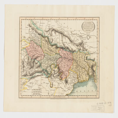
by John Cary.Covers portions of Northwest India, Pakistan, Afghanistan and Kashmir.Relief shown by hachures.Electronic reproduction. Cambridge, Mass. : Harvard Geospatial Library, 2009. Georeferenced image for use in a GIS.