25. Carte de la Tunisie Creator: Institut géographique national (France) (Creator) Date: Date Issued: 1895 Language: FrenchArabicLatin Geographic region: Place of Production: fr, France, ParisTunisia Extent: 1 map on 2 sheets : col. ; 110 x 65 cm., sheet 58 x 71 cm.
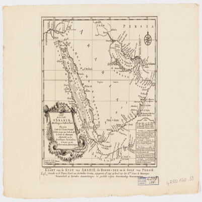
26. Carte de la coste d'Arabie, Mer Rouge et Golfe de Persetirée de la Carte de l'Océan Oriental publiée en 1740 par Ordre de Mgr le Comte de Maurepas augmentée sur des remarques particulières et dressée sur des observations astronomiques = Kaart van de Kust van Arabië, de Roode-Zee en de Gulf van Persië Gemaakt na de Fransse-Kaart van den Ooster-Ocean uitgegeven A. 1740 op Bevel van den Hre Grave de Maurepas Vermeederd op byzondere Aanmerkingen, en geschikt volgens Sterrekundige-Waarnemingen Creator: Schley, Jacobus van der, 1715-1779 (المنشئ) Date: Date Issued: between 1747 and 1767] Language: FrenchDutch Geographic region: Place of Production: ne, Netherlands, [HagueArabian Peninsula Extent: 1 map ; 24 x 21 cm.
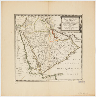
27. Carte des trois Arabiestirée en partie de l'Arabe de Nubie, en partie de diuers autres autheurs Creator: Sanson, Nicolas, 1600-1667 (المنشئ) Date: Date Issued: 1654 Language: French Geographic region: Place of Production: fr, France, ParisArabian Peninsula Extent: 1 map : hand col. ; 39 x 47 cm.
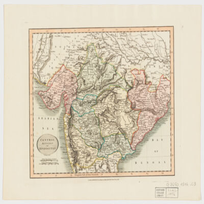
28. Central division of Hindoostan Creator: Cary, John, approximately 1754-1835 (المنشئ) Date: Date Issued: June 1, 1816 Language: English Geographic region: Place of Production: enk, England, LondonIndia Extent: 1 map : hand col. ; 22 x 27 cm.
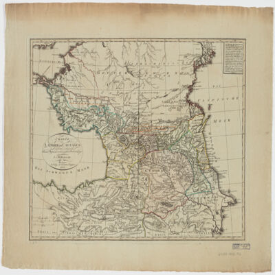
29. Charte der Laender am Caucasus nach den besten vorhandenen Creator: Reinecke, J. C. M. (Johann Christoph Matthias), 1770-1818 (المنشئ) Date: Date Issued: 1802 Language: German Geographic region: Place of Production: gw, Germany, WeimarCaucasus, SouthRussiaTurkey Extent: 1 map : hand col. ; 42 x 54 cm.
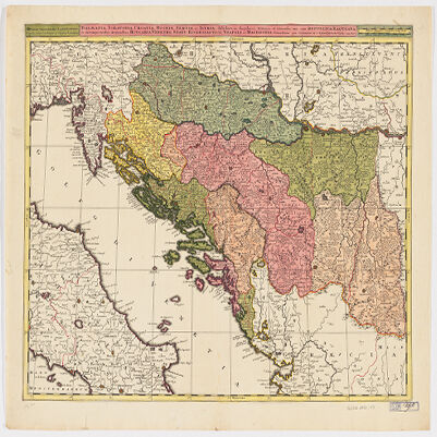
30. Dalmatia, Sclavonia, Croatia, Bosnia, Servia, et Istriadistributa in singulares ditiones et diœceses, una cum Republica Ragusana, et circumjacentibus regionibus, Hungaria, Venetiis, statu ecclesiastico, Napoli et Macedonia Creator: Valck, G. (Gerard), 1651-1726 (Creator) Date: Date Issued: [1710?] Language: LatinItalian Geographic region: Place of Production: ne, Netherlands, [Amsterdam]Balkan PeninsulaAdriatic Coast (Balkan Peninsula)Adriatic Coast (Italy) Extent: 1 map : hand col. ; 45 x 57 cm.
31. Das Kœnigreich Bosnien, und die Herzegovina (Rama) samt den angrœnzenden Provinzen von Croatien, Sclavonien, Temesvar, Servien, Albanien, Ragusa, und den Venetianischen Dalmatien Creator: Schimek, Maximilian. (المنشئ) Date: Date Issued: 1788 Language: German Geographic region: Place of Production: au, Austria, WienBalkan Peninsula Extent: 1 map : hand col. ; 65 x 103 cm.
32. Delineatio regionis Bassora cum pagis fluminibus et insulis, quæ christiani sancti Ioannis incolunt Creator: Dapper, Olfert, 1635 or 1636-1689 (المنشئ) Date: Date Issued: 1680?] Language: Latin Geographic region: Place of Production: ne, Netherlands, [AmsterdamIraqBaṣrah Region (Iraq) Extent: 1 map : hand col. ; 29 x 36 cm.
33. Die Balkan-Halbinsel in 4 BlätternTürkei, Rumänien, Griechenland, Serbien, Montenegro, Bulgarien Creator: Vogel, C. (Carl), 1828-1897 (Creator) Date: Date Issued: 1908 Language: German Geographic region: Place of Production: gw, Germany, GothaBalkan Peninsula Extent: 1 map : col. ; 84 x 66 cm.
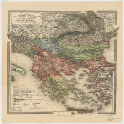
34. Die Staaten von Südost=EuropaRumänien, Serbien, Montenegro, Bulgarien, Kreta, Europ. Türkei, Griechenland Creator: Peucker, Karl, 1859-1940 (المنشئ) Date: Date Issued: 1903 Language: German Geographic region: Place of Production: au, Austria, WienBalkan PeninsulaTurkey Extent: 1 map : col. ; 51 x 37 cm.
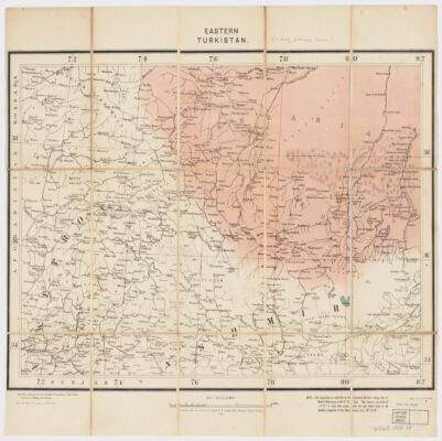
35. Eastern Turkistan Creator: Survey of India (المنشئ) Date: Date Issued: Feb. 1908 Language: English Geographic region: Place of Production: ii, India, [Calcutta]Asia, CentralXinjiang Uygur Zizhiqu (China)Northern Areas (Pakistan)North-West Frontier Province (Pakistan)Jammu and Kashmir (India) Extent: 1 map : col. ; 34 x 48 cm.
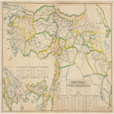
36. Empire Ottomandivision administrative Creator: Huber, R. (المنشئ) Date: Date Issued: 1899 Language: French Geographic region: Place of Production: fr, France, [S.l.]Turkey Extent: 1 map : col. ; 86 x 130 cm.