par E. Andriveau ; gravé le trait et les montagnes par Gérin, les écritures par P. Rousset, les eaux par Mme Fontaine.Covers portions of Israel, Jordan, Syria and Lebanon.Relief shown by hachures. Depth shown by sounding and isolines.Insets: [Sinai] (Scale [ca. 1:2,600,000]) -- Golfe de Suez -- [Cross section of the Palestine from the source of the Jordan to the Red Sea] -- [Panoramic view of the mountains of Palestine] -- Jérusalem d'après le plan de G. Williams (Scale [ca. 1:80,000])."No. 18"."Atlas usuel No. 23"."Atlas universel No.36".Includes notes and index.In French with place names in Latin, Arabic and Hebrew in Latin script.Electronic reproduction. Cambridge, Mass. : Harvard Geospatial Library, 2009. Georeferenced image for use in a GIS.
par le Sr. d'Anville ; Guill. De La Haye.Covers portions of Jordan, Syria, Lebanon, Israel, Turkey, Azerbaijan, Iran and Iraq.Relief shown pictorially.Colored in outline.In French with many place names also given with Roman-era Latin forms.Electronic reproduction. Cambridge, Mass. : Harvard College Library Digital Imaging Group, 2009. (Open Collections Program at Harvard University. Islamic Heritage Project). Copy digitized: XXXXX Library: [call no.].Electronic reproduction. Cambridge, Mass. : Harvard Geospatial Library, 2009. Georeferenced image for use in a GIS.
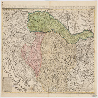
le très humble et très obéissant serviteur Étienne Briffaut.Shows battle places with date.Covers Bosnia and Hercegovina, and portions of Hungary, Croatia, Albania and Yugoslavia.Relief shown pictorially.Includes note and ill."Je me suis fais un devoir de Publier cette Carte Sous les Auspices de V. E. étant un des Capitaines de S.M.I. et Cath. qui entend mieux le métier de la guerre et qui marche sur les mêmes principes que le défunt Prince Eugène ayant le flême et la prudence come elle en a donné des preuves par les dernières campagnes d'Italie, et en dernier lieu par le combat contre les trouppes ottomanes arrivé le 28 7bris 737 près de la rivière de la Timock et suis avec un parfait dévouement et un pronfond respect de V. E.".In French with place names and a legend in Latin.Electronic reproduction. Cambridge, Mass. : Harvard College Library Digital Imaging Group, 2009. (Open Collections Program at Harvard University. Islamic Heritage Project). Copy digitized: XXXXX Library: [call no.].
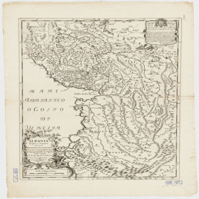
descritta con disegni fatti sul luogo da Giacomo Cantelli da Vignola suddito e geografo del Sereniss. Sig. Duca di Modena.Covers also portions of Croatia, Montenegro and Serbia.Relief shown pictorially.Includes a note in decorative cartouche and ill.Electronic reproduction. Cambridge, Mass. : Harvard College Library Digital Imaging Group, 2009. (Open Collections Program at Harvard University. Islamic Heritage Project). Copy digitized: Map Coll (Pusey) : MAP-LC G6830 1689 .C3.
by John Cary.Covers portions of Northwest India, Pakistan, Afghanistan and Kashmir.Relief shown by hachures.Electronic reproduction. Cambridge, Mass. : Harvard Geospatial Library, 2009. Georeferenced image for use in a GIS.
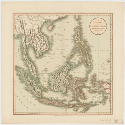
by John Cary.Relief shown pictorially and with shading.Prime meridian: Greenwich.Covers Sumatra, Java, Borneo, Sulawesi, the Philippines, Papua new Guinea and portions of China, Burma and Malaysia.Shows boundaries, rivers, roads and settlements.Electronic reproduction. Cambridge, Mass. : Harvard Geospatial Library, 2009. Georeferenced image for use in a GIS.Electronic reproduction. Cambridge, Mass. : Harvard College Library Digital Imaging Group, 2009. (Open Collections Program at Harvard University. Islamic Heritage Project). Copy digitized: Map Coll (Pusey) : MAP-LC G8000 1801 .C3.
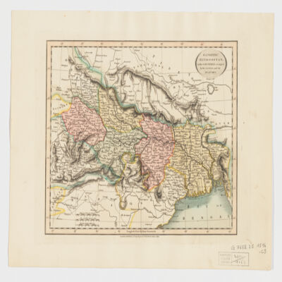
by John Cary.Covers Northeast India, Bangladesh and Nepal.Relief shown by hachures.Electronic reproduction. Cambridge, Mass. : Harvard College Library Digital Imaging Group, 2009. (Open Collections Program at Harvard University. Islamic Heritage Project). Copy digitized: Map Coll (Pusey) : MAP-LC G7652.I5 1816 .C3.Electronic reproduction. Cambridge, Mass. : Harvard Geospatial Library, 2009. Georeferenced image for use in a GIS.
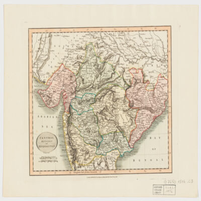
by John Cary.Covers Central and Northern India.Relief shown by hachures.Electronic reproduction. Cambridge, Mass. : Harvard Geospatial Library, 2009. Georeferenced image for use in a GIS.
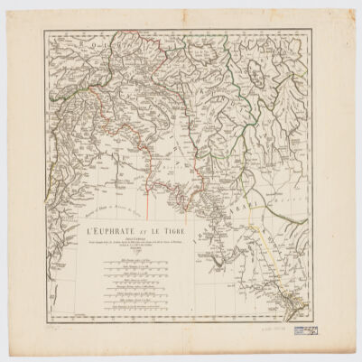
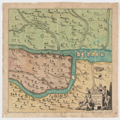
[Olfert Dapper].Covers a portion of southeastern Iraq where the Euphrates and the Tigris Rivers converge.Relief shown pictorially.From: Naukeurige beschryving van Asie: behelsende de gewesten van Mesopotamie, Babylonie, Assyrie, Anatolie, of Klein Asie: beneffens eene volkome beschrijving van gansch gelukkigh, woest, en petreesch of steenigh Arabie / Olfert Dapper. 1680.Oriented with North toward the left.Electronic reproduction. Cambridge, Mass. : Harvard College Library Digital Imaging Group, 2009. (Open Collections Program at Harvard University. Islamic Heritage Project). Copy digitized: Map Coll (Pusey) : MAP-LC G7610 1680 .D3.
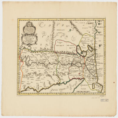
authore P. Duval Abbeviliense Regis Christianissimi geographo.Shows political divisions.Covers also a portion of Libya.Relief shown pictorially.Oriented with North to the right.Includes a note in a decorative cartouche: "A Monsieur Monsieur Doviat Sgr. de Montreuille, Con.er du Roy, et Maistre Ordinaire en sa Chambre des Comptes Par son Très humble et obéisant Serviteur P. Duval Géographe de sa Maiesté".In Latin with a note in French.Electronic reproduction. Cambridge, Mass. : Harvard College Library Digital Imaging Group, 2009. (Open Collections Program at Harvard University. Islamic Heritage Project). Copy digitized: Map Coll (Pusey) : MAP-LC G8300 1652 .D8.
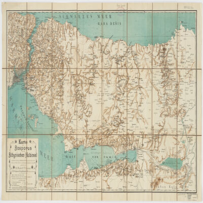
nach älteren Quellen (v. Moltke, Heinrich Kiepert, Brit. Admiralitätskarten, v. d. Goltz, v. Diest u.a.) und eigenen Aufnahmen im Jahre 1900 gezeichnet von Rudolf Fitzner ; Hof. Stdr. v. J. G. Tiedmann Nachf.Relief shown by hachures. Depths shown by contours.Includes index.Electronic reproduction. Cambridge, Mass. : Harvard College Library Digital Imaging Group, 2009. (Open Collections Program at Harvard University. Islamic Heritage Project). Copy digitized: Map Coll (Pusey) : MAP-LC G7433.I8 1900 .F5.Electronic reproduction. Cambridge, Mass. : Harvard Geospatial Library, 2014. Georeferenced image for use in a GIS.