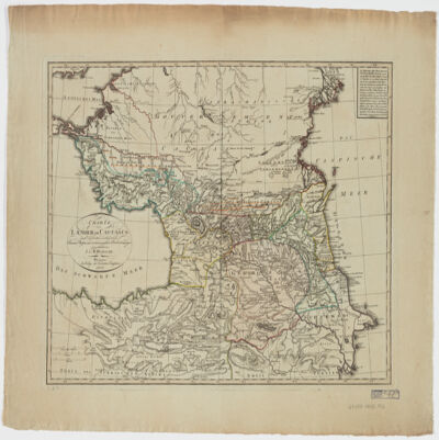
1. A generall mapp of the Coast of Barbarie, where in are the Kingdoms, and Estates of Morocco, Fez, Algiers, Tunis and Tripolialso the Kingdoms, Estates and Deserts of Barca, Egipt, Libya, Biledulgerid, Segelmesse and Darha: with the circumjacent counteries Creator: Sanson, Nicolas, 1600-1667 (المنشئ) Date: Date Issued: 1667?] Language: EnglishFrench Geographic region: Place of Production: enk, England, [LondonMoroccoTunisiaAlgeriaMauritania Extent: 1 map on 2 sheets ; 28 x 106 cm, sheets 35 x 57 cm and 35 x 59 cm.
2. A generall mapp of the Coast of Barbarie, where in are the Kingdoms, and Estates of Morocco, Fez, Algiers, Tunis and Tripolialso the Kingdoms, Estates and Deserts of Barca, Egipt, Libya, Biledulgerid, Segelmesse and Darha: with the circumjacent counteries Creator: Sanson, Nicolas, 1600-1667 (المنشئ) Date: Date Issued: 1667?] Language: EnglishFrench Geographic region: Place of Production: enk, England, [LondonMoroccoTunisiaAlgeriaMauritania Extent: 1 map on 2 sheets ; 28 x 106 cm, sheets 35 x 57 cm and 35 x 59 cm.
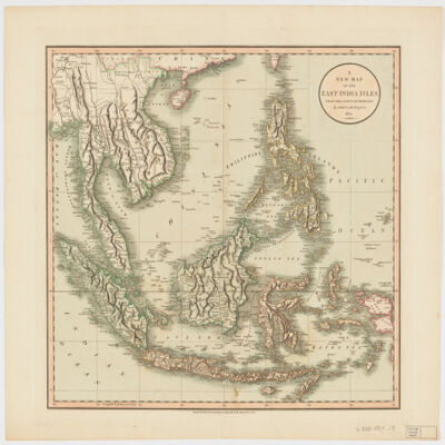
3. A new map of the East India Islesfrom the latest authorities Creator: Cary, John, approximately 1754-1835 (المنشئ) Date: Date Issued: Dec. 21, 1801 Language: English Geographic region: Place of Production: enk, England, LondonSoutheast AsiaEast IndiesIndonesiaMalay PeninsulaIndochinaPhilippines Extent: 1 map : hand col. ; 44 x 50 cm.
4. Africa with expedition routes, 1884 (Raster Image) Date: 200906 Geographic region: Africa103.12254157.594282-50.263329-73.867930
5. Africa, 1611 or 1612 (Raster Image) Date: 201204 Geographic region: AfricaMiddle EastEurope87.69118444.063898-44.943919-57.577607
6. Africa, 1700 (Raster Image) Date: 201202 Geographic region: Africa136.26490853.059878-47.801774-83.671687
7. Africa, 1730-1740 (Raster Image) Date: 201202 Geographic region: Africa87.87828149.440254-47.173313-56.184308
8. Africa, 1785 (Image 2 of 2) (Raster Image) Date: 201202 Geographic region: Africa129.30122453.016479-53.6349089.414992
9. Africa, 1795 (Raster Image) Date: 201202 Geographic region: Africa143.95762754.662494-51.894121-106.473090
10. Africa, 1797 (Raster Image) Date: 201201 Geographic region: Africa133.67160254.465561-53.071567-94.130562
11. Africa, 1800 (Raster Image) Date: 200905 Geographic region: Africa86.28407445.041388-45.849318-71.450052
12. Africa, 1805 (Raster Image) Date: 201202 Geographic region: Africa113.18103950.051365-43.455261-73.270698
13. Africa, 1815 (Raster Image) Date: 201202 Geographic region: Africa75.38448942.475973-39.724793-39.673843
14. Africa, 1834 (Raster Image) Date: 201202 Geographic region: Africa82.86500951.679764-51.621508-45.965406
15. Africa, 1890 (Raster Image) Date: 200905 Geographic region: Africa155.72943271.330211-45.438705-126.032625
16. Africa, Catholic Missions and Colonial Possessions, 1889 (Raster Image) Date: 200906 Geographic region: Africa98.68647849.591244-47.251107-60.109053
17. Africa, ca. 1680-1689 (Raster Image) Date: 201202 Geographic region: Africa116.36916252.713700-49.459512-86.118662
18. Africa, ca. 1725 (Raster Image) Date: 201204 Geographic region: AfricaMiddle EastEurope168.83259062.467856-63.513477-123.381192
19. Africae I Tab Creator: Mercator, Gerhard, 1512-1594 (المنشئ) Date: Date Issued: 1619?] Language: Latin Geographic region: Place of Production: xx, No place, unknown, or undetermined, [S.lAfrica, North Extent: 1 map ; 31 x 45 cm.
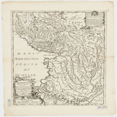
20. Albania Propria ouero Superiore detta anche Macedonia Occidentale Creator: Cantelli da Vignola, Giacomo, 1643-1719 (المنشئ) Date: Date Issued: 1689 Language: Italian Geographic region: Place of Production: it, Italy, RomaAlbania Extent: 1 map : 52 x 42 cm.
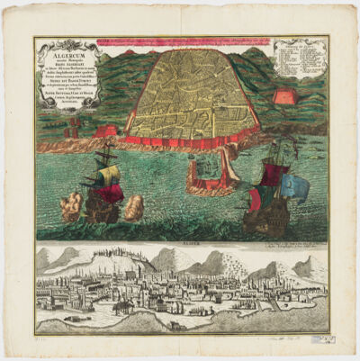
21. Algercum munita metropolis Regni Algeriani : in littore Africano Barbariæ in monte declivi Amphitheatri instar quadrata forma extructa, cum portu Commodissimo Sedes est Bassæ Turcici et ob piraticam per orbem famosissima =Algier die Befestigte Haupt-Statt des Königr. Algier, Auf die Africanischen Küsten in der Barbarey auf einem abhängigen Berg wie ein Amphiteatrum in gevierten form gebauet samt dem bequemen hasen. Ift die Residenz des Türkischen Bassa u: wegen ihrer Secrauberey Welt berussen Creator: Seutter, Matthaeus, 1678-1756 (المنشئ) Date: Date Issued: [1730?] Language: GermanLatin Geographic region: Place of Production: au, Austria, AugustaniAlgiers (Algeria) Extent: 1 view : hand col. ; 48 x 56 cm.
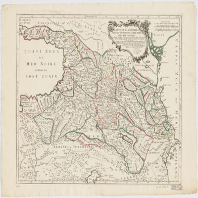
22. Carte de la Géorgie et des pays situés entre la mer Noire et la mer Caspiennedessinée en 1738 d'après les Cartes, Mémoires, Mesures et Observations des gens du Pays Creator: Santini, P. (المنشئ) Date: Date Issued: 1775 Language: FrenchGeorgian Geographic region: Place of Production: it, Italy, VeniceGeorgia (Republic)Armenia Extent: 1 map : hand col. ; 46 x 64 cm.
23. Carte de la Tunisie Creator: Institut géographique national (France) (Creator) Date: Date Issued: 1895 Language: FrenchArabicLatin Geographic region: Place of Production: fr, France, ParisTunisia Extent: 1 map on 2 sheets : col. ; 110 x 65 cm., sheet 58 x 71 cm.
24. Carte de la Tunisie Creator: Institut géographique national (France) (Creator) Date: Date Issued: 1895 Language: FrenchArabicLatin Geographic region: Place of Production: fr, France, ParisTunisia Extent: 1 map on 2 sheets : col. ; 110 x 65 cm., sheet 58 x 71 cm.
25. Carte de la Tunisie Creator: Institut géographique national (France) (Creator) Date: Date Issued: 1895 Language: FrenchArabicLatin Geographic region: Place of Production: fr, France, ParisTunisia Extent: 1 map on 2 sheets : col. ; 110 x 65 cm., sheet 58 x 71 cm.
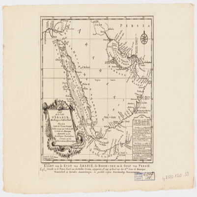
26. Carte de la coste d'Arabie, Mer Rouge et Golfe de Persetirée de la Carte de l'Océan Oriental publiée en 1740 par Ordre de Mgr le Comte de Maurepas augmentée sur des remarques particulières et dressée sur des observations astronomiques = Kaart van de Kust van Arabië, de Roode-Zee en de Gulf van Persië Gemaakt na de Fransse-Kaart van den Ooster-Ocean uitgegeven A. 1740 op Bevel van den Hre Grave de Maurepas Vermeederd op byzondere Aanmerkingen, en geschikt volgens Sterrekundige-Waarnemingen Creator: Schley, Jacobus van der, 1715-1779 (المنشئ) Date: Date Issued: between 1747 and 1767] Language: FrenchDutch Geographic region: Place of Production: ne, Netherlands, [HagueArabian Peninsula Extent: 1 map ; 24 x 21 cm.
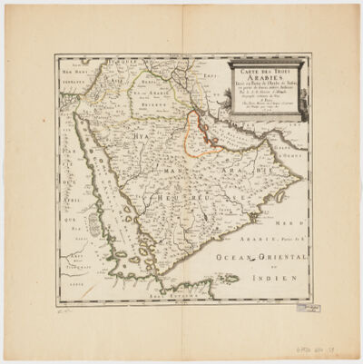
27. Carte des trois Arabiestirée en partie de l'Arabe de Nubie, en partie de diuers autres autheurs Creator: Sanson, Nicolas, 1600-1667 (المنشئ) Date: Date Issued: 1654 Language: French Geographic region: Place of Production: fr, France, ParisArabian Peninsula Extent: 1 map : hand col. ; 39 x 47 cm.
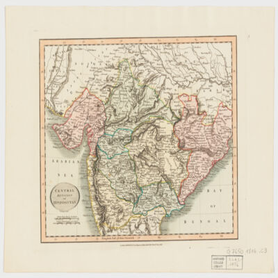
28. Central division of Hindoostan Creator: Cary, John, approximately 1754-1835 (المنشئ) Date: Date Issued: June 1, 1816 Language: English Geographic region: Place of Production: enk, England, LondonIndia Extent: 1 map : hand col. ; 22 x 27 cm.
29. Charte der Laender am Caucasus nach den besten vorhandenen Creator: Reinecke, J. C. M. (Johann Christoph Matthias), 1770-1818 (المنشئ) Date: Date Issued: 1802 Language: German Geographic region: Place of Production: gw, Germany, WeimarCaucasus, SouthRussiaTurkey Extent: 1 map : hand col. ; 42 x 54 cm.
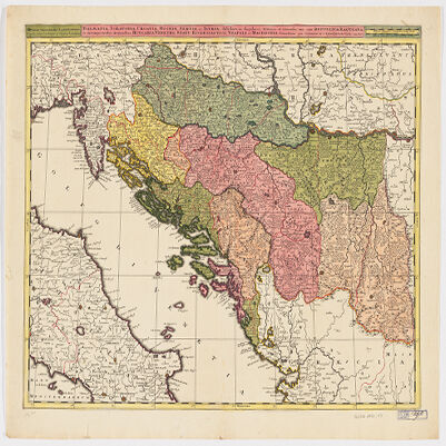
30. Dalmatia, Sclavonia, Croatia, Bosnia, Servia, et Istriadistributa in singulares ditiones et diœceses, una cum Republica Ragusana, et circumjacentibus regionibus, Hungaria, Venetiis, statu ecclesiastico, Napoli et Macedonia Creator: Valck, G. (Gerard), 1651-1726 (Creator) Date: Date Issued: [1710?] Language: LatinItalian Geographic region: Place of Production: ne, Netherlands, [Amsterdam]Balkan PeninsulaAdriatic Coast (Balkan Peninsula)Adriatic Coast (Italy) Extent: 1 map : hand col. ; 45 x 57 cm.
31. Das Kœnigreich Bosnien, und die Herzegovina (Rama) samt den angrœnzenden Provinzen von Croatien, Sclavonien, Temesvar, Servien, Albanien, Ragusa, und den Venetianischen Dalmatien Creator: Schimek, Maximilian. (المنشئ) Date: Date Issued: 1788 Language: German Geographic region: Place of Production: au, Austria, WienBalkan Peninsula Extent: 1 map : hand col. ; 65 x 103 cm.
32. Delineatio regionis Bassora cum pagis fluminibus et insulis, quæ christiani sancti Ioannis incolunt Creator: Dapper, Olfert, 1635 or 1636-1689 (المنشئ) Date: Date Issued: 1680?] Language: Latin Geographic region: Place of Production: ne, Netherlands, [AmsterdamIraqBaṣrah Region (Iraq) Extent: 1 map : hand col. ; 29 x 36 cm.
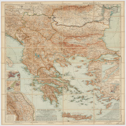
33. Die Balkan-Halbinsel in 4 BlätternTürkei, Rumänien, Griechenland, Serbien, Montenegro, Bulgarien Creator: Vogel, C. (Carl), 1828-1897 (Creator) Date: Date Issued: 1908 Language: German Geographic region: Place of Production: gw, Germany, GothaBalkan Peninsula Extent: 1 map : col. ; 84 x 66 cm.
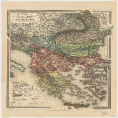
34. Die Staaten von Südost=EuropaRumänien, Serbien, Montenegro, Bulgarien, Kreta, Europ. Türkei, Griechenland Creator: Peucker, Karl, 1859-1940 (المنشئ) Date: Date Issued: 1903 Language: German Geographic region: Place of Production: au, Austria, WienBalkan PeninsulaTurkey Extent: 1 map : col. ; 51 x 37 cm.
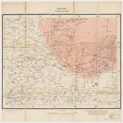
35. Eastern Turkistan Creator: Survey of India (المنشئ) Date: Date Issued: Feb. 1908 Language: English Geographic region: Place of Production: ii, India, [Calcutta]Asia, CentralXinjiang Uygur Zizhiqu (China)Northern Areas (Pakistan)North-West Frontier Province (Pakistan)Jammu and Kashmir (India) Extent: 1 map : col. ; 34 x 48 cm.
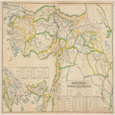
36. Empire Ottomandivision administrative Creator: Huber, R. (المنشئ) Date: Date Issued: 1899 Language: French Geographic region: Place of Production: fr, France, [S.l.]Turkey Extent: 1 map : col. ; 86 x 130 cm.
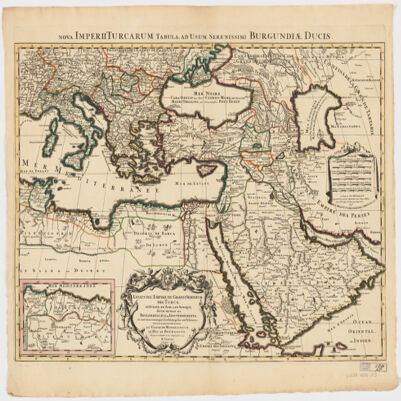
37. Empire de la Porte ottomane en Europe, en Asie et en Afrique avec les pays qui lui sont tributaires Creator: Lotter Brothers (Firm) (Creator) Date: Date Issued: [1790?] Language: French Geographic region: Place of Production: gw, Germany, AugsburgMiddle EastTurkeyEurope, SouthernAfrica, North Extent: 1 map : hand col. ; 47 x 55 cm.
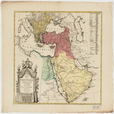
38. Estats de l'Empire du grand Seigneur des Turcs en Europe, en Asie, et en Afriquedivisé en tous ses Beglerbeglicz ou Gouvernements; où sont aussi remarqués les Estats qui luy sont Tributaires Creator: Jaillot, Alexis Hubert, 1632?-1712 (المنشئ) Date: Date Issued: 1696 Language: Latin Geographic region: Place of Production: fr, France, ParisTurkeyMiddle EastAfrica, NorthEurope, SouthernNorth AfricaSouthern Europe Time period: Ottoman Empire, 1288-1918 Extent: 1 map : hand colored ; 44 x 60 cm
39. Europe & Mediterranean Sea Region, 1705 (Image 2 of 2) (Raster Image) Date: 201109 Geographic region: Mediterranean SeaBlack SeaAlbaniaArmeniaAzerbaijanBosnia and HerzegovinaBulgariaCroatiaCyprusEgyptGaza StripGeorgiaGreeceHungaryIsraelItalyJordanKazakhstanLebanonLibyaMacedoniaMoldovaMontenegroPolandRomaniaRussiaSaudi ArabiaSerbiaSlovakiaSyriaTurkeyUkraineWest BankEuropeAfrica, NorthMiddle East59.63941753.88769019.1023876.174040 Extent: 2 images
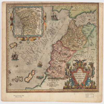
40. Fessae, et Marocchi Regna Africae celeberr Creator: Ortelius, Abraham, 1527-1598 (المنشئ) Date: Date Issued: 1595 Language: Latin Geographic region: Place of Production: be, Belgium, [Antwerp]MoroccoGibraltar, Strait ofCanary Islands Extent: 1 map : hand col. ; 37 x 48 cm.
41. Gangetic Hindoostan or the countries occupied by the Ganges and the branches Creator: Cary, John, approximately 1754-1835 (المنشئ) Date: Date Issued: June 1, 1816 Language: English Geographic region: Place of Production: enk, England, LondonIndia, NortheasternBangladeshNepal Extent: 1 map : hand col. ; 22 x 27 cm.
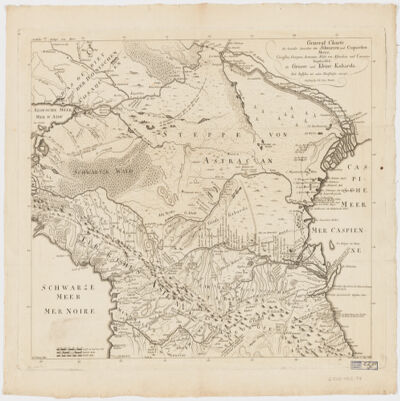
42. General Charte der Laender Zwischen dem Schwarzen und Caspischen MeereCircassien, Georgien, Armenien, Wüste von Astrachan und Caucasus hauptsoechlich die Grosse und Kleine Kabarda Creator: Treuttel, Jean-Georges, 1744-1826 (المنشئ) Date: Date Issued: [between 1765 and 1800?] Language: GermanFrench Geographic region: Place of Production: gw, Germany, StrasburgRussia (Federation)GeorgiaCaucasus, South Extent: 1 map ; 46 x 57 cm.
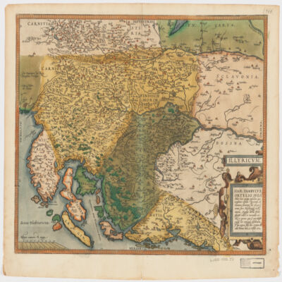
43. Illyricvm Creator: Zsámboki, János, 1531-1584 (المنشئ) Date: Date Issued: Oct. 25, 1572 Language: Latin Geographic region: Place of Production: au, Austria, ViennæBalkan PeninsulaSloveniaCroatiaBosnia and Herzegovina Extent: 1 map : hand col. ; 36 x 46 cm.
44. Imperium Turcicum per Europam, Asiam Et Africam se extendens et secundum Beglerbegatus sive Praefecturas accurate distinctum Creator: Seutter, Matthaeus, 1678-1756 (المنشئ) Date: Date Issued: [1720?] Language: GermanLatin Geographic region: Place of Production: gw, Germany, AugspurgTurkeyIslamic countries Extent: 1 map : hand col. ; 27 x 25 cm., on sheet 61 x 52 cm.
45. Indian Ocean Region, ca. 1690 (Raster Image) Date: 201110 Geographic region: AfghanistanAlgeriaAngolaArmeniaAustraliaAzerbaijanBahrainBangladeshBhutanBotswanaBritish Indian Ocean TerritoryBruneiBurmaBurundiCambodiaCameroonCentral Africian RepublicChadChinaChristmas IslandCocos (Keeling) IslandsComorosCongo, Democratic Republic of theCongo, Republic of theDjiboutiEgyptEritreaEthiopiaGabonGlorioso IslandsGuamIndiaIndonesiaIranIraqIsraelJapanJordanJuan de Nova IslandKazakhstanKenyaKuwaitKyrgyzstanLaosLesothoLibyaMadagascarMalawiMalaysiaMaldivesMauritiusMayotteMozambiqueNamibiaNepalNigerNigeriaNorth KoreaNorthern Mariana IslandsOmanPakistanPalauPapua New GuineaPhilippinesQatarReunionRwandaSaudi ArabiaSeychellesSingaporeSomaliaSouth AfricaSouth KoreaSri LankaSudanSwazilandSyriaTajikistanTanzaniaThailandTimor-LesteTurkeyTurkmenistanUgandaUnited Arab EmiratesUzbekistanVietnamYemenZambiaZimbabweIndian OceanAsiaSouth AsiaSoutheast AsiaAfrica, East177.31452253.283629-65.180727-13.682351
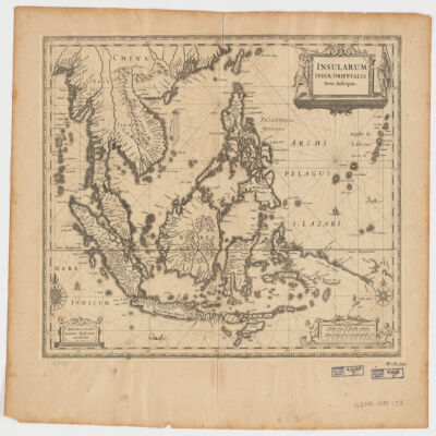
46. Insularum Indiae Orientalisnova descriptio Creator: Jansson, Jan, 1588-1664 (المنشئ) Date: Date Issued: [1650?] Language: Latin Geographic region: Place of Production: ne, Netherlands, AmstelodamiSoutheast AsiaEast Indies Extent: 1 map ; 37 x 48 cm.
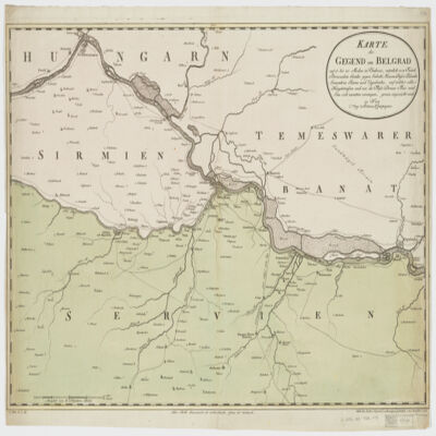
47. Karte der Gegend um Belgradauf 15 bis 20 Meilen in Umkreis, nämlich von Futak Peterwardein Semlin gegen Sabatz, Hassan Bassa Palanka Semendria Rama und Uypalanka, auf welcher alle Hauptstrassen und wie die Flüsse Donau Theis und Sau sich zusammen vereinigen, genau angezeicht sind Creator: Mansfeld. (المنشئ) Date: Date Issued: 1788 Language: German Geographic region: Place of Production: au, Austria, WienSerbiaHungary Extent: 1 map : hand col. ; 47 x 67 cm.
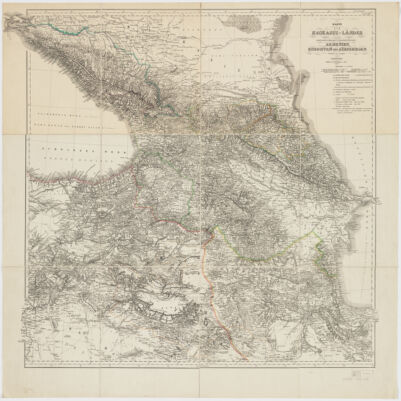
48. Karte der Kaukasus-Länder und der angränzenden Türkischen und Persischen Provinzen Armenien, Kurdistan, und Azerbeidjan Creator: Kiepert, Heinrich, 1818-1899 (المنشئ) Date: Date Issued: 1854 Language: German Geographic region: Place of Production: gw, Germany, BerlinCaucasus Extent: 1 map : hand col., dissected and mounted on linen ; 69 x 75 cm.
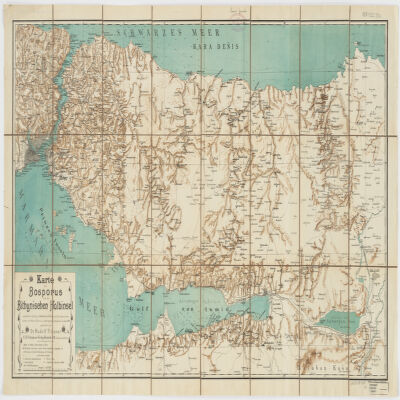
49. Karte des Bosporus und der Bithynischen Halbinsel Creator: Fitzner, Rudolph, 1864- (المنشئ) Date: Date Issued: [1900?] Language: German Geographic region: Place of Production: gw, Germany, Rostockİstanbul İli (Turkey)Kocaeli İli (Turkey)Sakarya İli (Turkey)Bosporus (Turkey) Extent: 1 map : col. ; 47 x 87 cm.
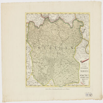
50. Karte von dem Königreich Serbien Creator: Müller, F. (المنشئ) Date: Date Issued: [1790?] Language: German Geographic region: Place of Production: au, Austria, WienSerbia Extent: 1 map : hand col. ; 36 x 43 cm.
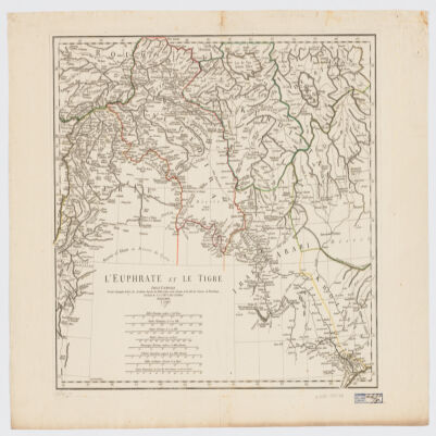
51. L' Euphrate et le Tigre Creator: Anville, Jean Baptiste Bourguignon d', 1697-1782 (المنشئ) Date: Date Issued: 1779 Language: FrenchLatin Geographic region: Place of Production: fr, France, [ParisEuphrates RiverTigris RiverIraqSyriaTurkey Extent: 1 map : hand col. ; 42 x 51 cm.
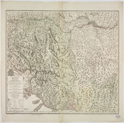
52. Le Royaume de Bosnie, dans son entier, dédié a son Excellence Monseignr. le feld Maréchal Comte de Khewenhüller Colonel d'un Régiment de Dragon Vice Roy d'Esclavonie, du Duché de Syrmie et Gouverneur de la Forteresse d'Essegg etc Creator: Briffaut, Étienne. (المنشئ) Date: Date Issued: 1740 Language: FrenchLatin Geographic region: Place of Production: fr, France, VienneBosnia and HerzegovinaCroatia Extent: 1 map : hand col. ; 60 x 90 cm.
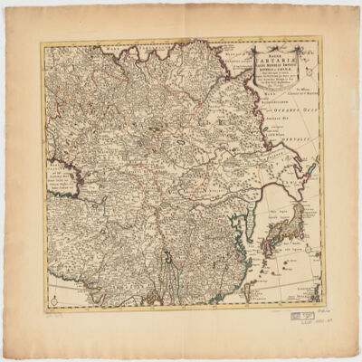
53. Magnae Tartariae, magni Mogolis Imperii, Iaponiae et Chinaenova descriptio ex tabula Creator: Wit, Frederik de. (المنشئ) Date: Date Issued: [ca. 1725?] Language: Latin Geographic region: Place of Production: ne, Netherlands, AmstelodamiAsia Extent: 1 map : hand col. ; 41 x 52 cm.
54. Magni Mogolis Imperium de novo correctum et divisum Creator: Wit, Frederik de. (المنشئ) Date: Date Issued: [1707?] Language: Latin Geographic region: Place of Production: ne, Netherlands, AmstelodamiMogul EmpireSouth AsiaAsia, Central Extent: 1 map : hand col. 40 x 50 cm.
55. Main Title: "Great Hornbill," folio from the Shah Jahan Album (NY Met 55.121.10.14)Image Title: Full view. 17198909 Creator: Mansur, Indian painter (artist), 1551-1630 (Artist)Mir 'Ali Husayni Haravi, b. Herat; d. Bukhara, Iranian (Calligrapher) Date: 16001640Early 17th cent. Geographic region: Place of Production: India Extent: 38.7 centimeters; 26.7 centimeters
56. Main Title: "Great Hornbill," folio from the Shah Jahan Album (NY Met 55.121.10.14)Image Title: f. 5v: Page of calligraphy; a mu'amma (riddle) surrounded by Persian ghazals by Suhayli and Asafi (full page) 23901068 Creator: Mansur, Indian painter (artist), 1551-1630 (Artist)Mir 'Ali Husayni Haravi, b. Herat; d. Bukhara, Iranian (Calligrapher) Date: 16001640Early 17th cent. Geographic region: Place of Production: India Extent: 38.7 centimeters; 26.7 centimeters
57. Main Title: 'Aja'ib al-Makhluqat (Chester Beatty, MS. Pers. 212)Image Title: f.108b: Fauna of the island of Java; tree-dwellers (detail) 21006864 Creator: al-Qazwini, b. Qazvin ca. 1203/600 AH, Iranian (Author) Date: 1545c. 1545 Geographic region: Place of Production: Shiraz, Shiraz, Ostan-e Fars, Iran Extent: 31.9 x 18.9 cm
58. Main Title: 'Aja'ib al-Makhluqat (Chester Beatty, MS. Pers. 212)Image Title: f.? (detail) 21006865 Creator: al-Qazwini, b. Qazvin ca. 1203/600 AH, Iranian (Author) Date: 1545c. 1545 Geographic region: Place of Production: Shiraz, Shiraz, Ostan-e Fars, Iran Extent: 31.9 x 18.9 cm
59. Main Title: 'Aja'ib al-Makhluqat (Chester Beatty, MS. Pers. 212)Image Title: f.? (detail) 21006860 Creator: al-Qazwini, b. Qazvin ca. 1203/600 AH, Iranian (Author) Date: 1545c. 1545 Geographic region: Place of Production: Shiraz, Shiraz, Ostan-e Fars, Iran Extent: 31.9 x 18.9 cm
60. Main Title: 'Aja'ib al-Makhluqat (Chester Beatty, MS. Pers. 212)Image Title: f.109b: Tree-dwellers, buffalo, and rhinoceros on the island of Ramin (full view) 21006862 Creator: al-Qazwini, b. Qazvin ca. 1203/600 AH, Iranian (Author) Date: 1545c. 1545 Geographic region: Place of Production: Shiraz, Shiraz, Ostan-e Fars, Iran Extent: 31.9 x 18.9 cm
61. Main Title: 'Aja'ib al-Makhluqat (Chester Beatty, MS. Pers. 212)Image Title: f.108b: Fauna of the island of Java (full view) 21006863 Creator: al-Qazwini, b. Qazvin ca. 1203/600 AH, Iranian (Author) Date: 1545c. 1545 Geographic region: Place of Production: Shiraz, Shiraz, Ostan-e Fars, Iran Extent: 31.9 x 18.9 cm
62. Main Title: 'Aja'ib al-Makhluqat (Chester Beatty, MS. Pers. 212)Image Title: General view, f. 109b: Tree-dwellers, buffalo, and rhinoceros on the island of Ramin 21006861 Creator: al-Qazwini, b. Qazvin ca. 1203/600 AH, Iranian (Author) Date: 1545c. 1545 Geographic region: Place of Production: Shiraz, Shiraz, Ostan-e Fars, Iran Extent: 31.9 x 18.9 cm
63. Main Title: 'Aja'ib al-Makhluqat (Chester Beatty, MS. Pers. 212)Image Title: General view, f. 405b: Talismans and magic; a dragon before a door with ornate paneling 21006852 Creator: al-Qazwini, b. Qazvin ca. 1203/600 AH, Iranian (Author) Date: 1545c. 1545 Geographic region: Place of Production: Shiraz, Shiraz, Ostan-e Fars, Iran Extent: 31.9 x 18.9 cm
64. Main Title: 'Aja'ib al-Makhluqat (Chester Beatty, MS. Pers. 212)Image Title: f. 108b: Strange inhabitants of an island (detail) 21006851 Creator: al-Qazwini, b. Qazvin ca. 1203/600 AH, Iranian (Author) Date: 1545c. 1545 Geographic region: Place of Production: Shiraz, Shiraz, Ostan-e Fars, Iran Extent: 31.9 x 18.9 cm
65. Main Title: 'Aja'ib al-Makhluqat (Chester Beatty, MS. Pers. 212)Image Title: f. 108b: Fauna of the island of Java (detail) 21006854 Creator: al-Qazwini, b. Qazvin ca. 1203/600 AH, Iranian (Author) Date: 1545c. 1545 Geographic region: Place of Production: Shiraz, Shiraz, Ostan-e Fars, Iran Extent: 31.9 x 18.9 cm
66. Main Title: 'Aja'ib al-Makhluqat (Chester Beatty, MS. Pers. 212)Image Title: f. 108b: Strange inhabitants of an island (detail) 21006853 Creator: al-Qazwini, b. Qazvin ca. 1203/600 AH, Iranian (Author) Date: 1545c. 1545 Geographic region: Place of Production: Shiraz, Shiraz, Ostan-e Fars, Iran Extent: 31.9 x 18.9 cm
67. Main Title: 'Aja'ib al-Makhluqat (Chester Beatty, MS. Pers. 212)Image Title: f. 108b: Fauna of the island of Java (detail) 20331098 Creator: al-Qazwini, b. Qazvin ca. 1203/600 AH, Iranian (Author) Date: 1545c. 1545 Geographic region: Place of Production: Shiraz, Shiraz, Ostan-e Fars, Iran Extent: 31.9 x 18.9 cm
68. Main Title: 'Aja'ib al-Makhluqat (Chester Beatty, MS. Pers. 212)Image Title: f. 109b: Rhinoceros, buffalo, and tree-dwellers 20331078 Creator: al-Qazwini, b. Qazvin ca. 1203/600 AH, Iranian (Author) Date: 1545c. 1545 Geographic region: Place of Production: Shiraz, Shiraz, Ostan-e Fars, Iran Extent: 31.9 x 18.9 cm
69. Main Title: 'Aja'ib al-Makhluqat (Chester Beatty, MS. Pers. 212)Image Title: f.405b: Talismans and magic; a dragon before a door with ornate paneling (detail) 21006850 Creator: al-Qazwini, b. Qazvin ca. 1203/600 AH, Iranian (Author) Date: 1545c. 1545 Geographic region: Place of Production: Shiraz, Shiraz, Ostan-e Fars, Iran Extent: 31.9 x 18.9 cm
70. Main Title: 'Aja'ib al-Makhluqat (Chester Beatty, MS. Pers. 212)Image Title: f. ?: A monstrosity (detail) 21006859 Creator: al-Qazwini, b. Qazvin ca. 1203/600 AH, Iranian (Author) Date: 1545c. 1545 Geographic region: Place of Production: Shiraz, Shiraz, Ostan-e Fars, Iran Extent: 31.9 x 18.9 cm
71. Main Title: 'Aja'ib al-Makhluqat (Chester Beatty, MS. Pers. 212)Image Title: General view, f. 153: Diagram of the Seven Climates 21006857 Creator: al-Qazwini, b. Qazvin ca. 1203/600 AH, Iranian (Author) Date: 1545c. 1545 Geographic region: Place of Production: Shiraz, Shiraz, Ostan-e Fars, Iran Extent: 31.9 x 18.9 cm
72. Main Title: 'Aja'ib al-Makhluqat (Chester Beatty, MS. Pers. 212)Image Title: f.108b: Fauna of the island of Java (detail) 21006855 Creator: al-Qazwini, b. Qazvin ca. 1203/600 AH, Iranian (Author) Date: 1545c. 1545 Geographic region: Place of Production: Shiraz, Shiraz, Ostan-e Fars, Iran Extent: 31.9 x 18.9 cm
73. Main Title: 'Aja'ib al-Makhluqat (Chester Beatty, MS. Pers. 212)Image Title: f.108b: Fauna of the island of Java (detail) 21006856 Creator: al-Qazwini, b. Qazvin ca. 1203/600 AH, Iranian (Author) Date: 1545c. 1545 Geographic region: Place of Production: Shiraz, Shiraz, Ostan-e Fars, Iran Extent: 31.9 x 18.9 cm
74. Main Title: 'Aja'ib al-Makhluqat (Chester Beatty, MS. Pers. 212)Image Title: f. ?: Detail 21006858 Creator: al-Qazwini, b. Qazvin ca. 1203/600 AH, Iranian (Author) Date: 1545c. 1545 Geographic region: Place of Production: Shiraz, Shiraz, Ostan-e Fars, Iran Extent: 31.9 x 18.9 cm
75. Main Title: ? Raga: A princess on a throne with a maid and two musiciansImage Title: General view 10898287 Date: 17001720c. early 18th century Extent: height 18.3 centimeters; width 21 centimeters
76. Main Title: A Beauty (San Diego Museum of Art, 1990.323)Image Title: Full view 22395809 Creator: Muhammad 'Ali, Indian (Artist) Date: 1625circ. 1625 Extent: 15 cm x 7 cm.
77. Main Title: A Beauty (San Diego Museum of Art, 1990.323)Image Title: Full view (reverse image) 22395798 Creator: Muhammad 'Ali, Indian (Artist) Date: 1625circ. 1625 Extent: 15 cm x 7 cm.
78. Main Title: A Beauty (San Diego Museum of Art, 1990.323)Image Title: Full view 24469495 Creator: Muhammad 'Ali, Indian (Artist) Date: 1625circ. 1625 Extent: 15 cm x 7 cm.
79. Main Title: A Camel (Harvard Art Museums, Cambridge, MA, 2011.534)Image Title: Full view 17658933 Creator: Mu'in Mussavir, b. ca. 1617; fl. 1635-97, Iranian (Artist) Date: 1678 Extent: 28 x 19 cm.
80. Main Title: A Camel (Harvard Art Museums, Cambridge, MA, 2011.534)Image Title: Detail view 17658934 Creator: Mu'in Mussavir, b. ca. 1617; fl. 1635-97, Iranian (Artist) Date: 1678 Extent: 28 x 19 cm.
81. Main Title: A Camel (Harvard Art Museums, Cambridge, MA, 2011.534)Image Title: Detail view 17658876 Creator: Mu'in Mussavir, b. ca. 1617; fl. 1635-97, Iranian (Artist) Date: 1678 Extent: 28 x 19 cm.
82. Main Title: A Chukar Partridge (Sackler Gallery, Smithsonian Institution, S1986.413)Image Title: General view 22350330 Date: 15501599c. late 16th century Extent: 29.3 x 19.9 cm.
83. Main Title: A Cow and Calf (Private Collection)Image Title: Full view 22112873 Creator: Basawan, Indian miniaturist, active ca. 1556-1600 (Artist) Date: 15701575circ. 1570-1575 Extent: 28.6 x 18.7cm
84. Main Title: A Darbar of Jahangir (Freer F1907.202)Image Title: Detail 21093053 Date: 16001625early 17th cent. Extent: 32.8 x 19.9 cm
85. Main Title: A Darbar of Jahangir (Freer F1907.202)Image Title: Detail 21093042 Date: 16001625early 17th cent. Extent: 32.8 x 19.9 cm
86. Main Title: A Female Afghan Hound (Aga Khan IR.M.79)Image Title: General view 16697129 Date: 1605c.1605 Geographic region: Place of Production: Isfahan, Esfahan, Iran Extent: height 12.7 centimeters; width 7.6 centimeters
87. Main Title: A Group of Musicians (Collection Karl J. Khandalavala)Image Title: Full view 23087670 Creator: Nainsukh, Indian painter, ca. 1710-1778 (Artist) Date: 17451750circ. 1745-1750 Extent: 13.9 x 17.1 cm.
88. Main Title: A Group of Musicians (Collection Karl J. Khandalavala)Image Title: Detail view 23087669 Creator: Nainsukh, Indian painter, ca. 1710-1778 (Artist) Date: 17451750circ. 1745-1750 Extent: 13.9 x 17.1 cm.
89. Main Title: A Group of Musicians (Collection Karl J. Khandalavala)Image Title: Detail view 23087668 Creator: Nainsukh, Indian painter, ca. 1710-1778 (Artist) Date: 17451750circ. 1745-1750 Extent: 13.9 x 17.1 cm.
90. Main Title: A Hunting Scene (MFA, 06.132)Image Title: Full view 21093203 Date: 1500159916th cent. Extent: 27.9 x 19.3 cm
91. Main Title: A Krishna Shrine (Ashmolean, LI118.3)Image Title: Full view 22113832 Date: 1740circ. 1740 Geographic region: Place of Production: Chamba, Himāchal Pradesh, India Extent: 61 x 43.5 cm.
92. Main Title: A Lady of Fashion (Harvard Art Museums, Cambridge, MA, 2009.202.56)Image Title: Detail view 16500438 Date: 17751799Late 18th cent. Geographic region: Place of Production: Kangra, Himāchal Pradesh, India Extent: 29 x 21 cm.
93. Main Title: A Lady of Fashion (Harvard Art Museums, Cambridge, MA, 2009.202.56)Image Title: Detail view 16500439 Date: 17751799Late 18th cent. Geographic region: Place of Production: Kangra, Himāchal Pradesh, India Extent: 29 x 21 cm.
94. Main Title: A Lady of Fashion (Harvard Art Museums, Cambridge, MA, 2009.202.56)Image Title: Detail view 16500446 Date: 17751799Late 18th cent. Geographic region: Place of Production: Kangra, Himāchal Pradesh, India Extent: 29 x 21 cm.
95. Main Title: A Lady of Fashion (Harvard Art Museums, Cambridge, MA, 2009.202.56)Image Title: Full view 16500447 Date: 17751799Late 18th cent. Geographic region: Place of Production: Kangra, Himāchal Pradesh, India Extent: 29 x 21 cm.
96. Main Title: A Man and a Lion in a Rocky Landscape (Harvard Art Museums, 1961.57)Image Title: Full view 17719157 Date: 1500159916th cent. Geographic region: Place of Production: Qazvin, Iran Extent: 31 x 20.9 cm