by Mounsieur Sanson ; rendred into English and illustrated by Richard Blome ; Francis Lamb Sculpit.Covers also portions of Spain, Sicily, Greece, Crete, Turkey and Cyprus.Relief shown pictorially.Includes ill. and index.In English, translated from French.
by Mounsieur Sanson ; rendred into English and illustrated by Richard Blome ; Francis Lamb Sculpit.Covers also portions of Spain, Sicily, Greece, Crete, Turkey and Cyprus.Relief shown pictorially.Includes ill. and index.In English, translated from French.
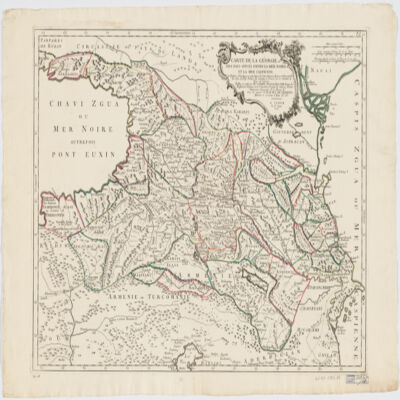
traduit du Géorgien en François par le Secrétaire du Roy de Géorgie.Covers also portions of Turkey, Armenia, Azerbaijan and Russia.Relief shown pictorially.Colored in outline."Publiée en 1766 par M. Joseph Nicolas de Lisle, Doyen des Proffesseurs royaux de l'Académie Royale des Sciences, Premier Astronome Géographe de la Marine &a. Sous les auspices de M. le Duc de Choiseul, Ministre et Secrétaire d'État &a &a.""P. II".Includes ill.In French, translated from Georgian.Electronic reproduction. Cambridge, Mass. : Harvard College Library Digital Imaging Group, 2009. (Open Collections Program at Harvard University. Islamic Heritage Project). Copy digitized: XXXXX Library: [call no.].
dressée au Service géographique de l'armée.Covers also a portion of Algeria and Libya.Relief shown by shading and spot heights. Depth shown by isolines.In French with place names in Arabic and Latin in Latin script.Table of Contents: "Tunisie (800 000e) Flle Nord" -- "Tunisie (800 000e) Flle Sud".
dressée au Service géographique de l'armée.Covers also a portion of Algeria and Libya.Relief shown by shading and spot heights. Depth shown by isolines.In French with place names in Arabic and Latin in Latin script.Table of Contents: "Tunisie (800 000e) Flle Nord" -- "Tunisie (800 000e) Flle Sud".
dressée au Service géographique de l'armée.Covers also a portion of Algeria and Libya.Relief shown by shading and spot heights. Depth shown by isolines.In French with place names in Arabic and Latin in Latin script.Table of Contents: "Tunisie (800 000e) Flle Nord" -- "Tunisie (800 000e) Flle Sud".
J. V. Schley.Prime meridian: Ferro.Depths shown by shading.Appears in: Histoire générale des voyages / Antoine-François Prevost. 1747-67. Vol. 1.Includes note.Map in French and Deutsch.Electronic reproduction. Cambridge, Mass. : Harvard Geospatial Library, 2009. Georeferenced image for use in a GIS.Electronic reproduction. Cambridge, Mass. : Harvard College Library Digital Imaging Group, 2009. (Open Collections Program at Harvard University. Islamic Heritage Project). Copy digitized: Map Coll (Pusey) : MAP-LC G7520 1740 .S3.
par le S. N. Sanson d'Abbeville Geographe ordinaire du Roy ; J. Somer sculp.Relief shown pictorially.Colored in outline.Place names in Latin and French.Electronic reproduction. Cambridge, Mass. : Harvard Geospatial Library, 2009. Georeferenced image for use in a GIS.Electronic reproduction. Cambridge, Mass. : Harvard College Library Digital Imaging Group, 2009. (Open Collections Program at Harvard University. Islamic Heritage Project). Copy digitized: Map Coll (Pusey) : MAP-LC G7520 1654 .S3 .
dressée d'après le Salnamé 1899/1317 par R. Huber.Covers Turkey, Lebanon, Crete and portions of Israel, Syria, Iraq, Iran,Originally published on four sheets.Colored in outline.Includes index and tables with population statistics.Insets: Crete -- [Vilayets Andrinople, Salonique, Monastir, Janina, Uskub, Scoutari, Constantinople] -- [Beyrouth] -- [Basra].Electronic reproduction. Cambridge, Mass. : Harvard Geospatial Library, 2009. Georeferenced image for use in a GIS.Electronic reproduction. Cambridge, Mass. : Harvard College Library Digital Imaging Group, 2009. (Open Collections Program at Harvard University. Islamic Heritage Project). Copy digitized: Map Coll (Pusey) : MAP-LC G7430 1899 .H8.
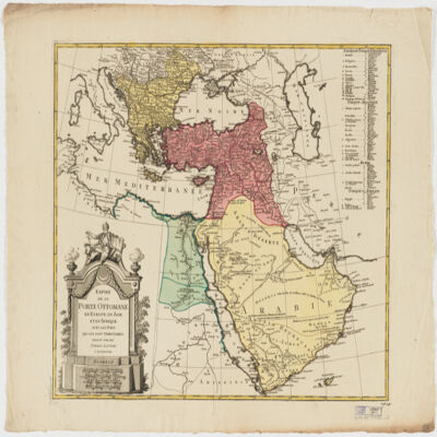
dressé par les Frères Lotter.Covers Egypt, the Arabian Peninsula, Israel, Lebanon, Syria, Iraq, Turkey, Greece, the Balkan Peninsula and Cyprus, and portions of Libya, Tunisia, Sudan, Iran, Azerbaijan, Georgia, Armenia, Russia and Italy.Relief shown pictorially.Includes list of countries and ill.Electronic reproduction. Cambridge, Mass. : Harvard Geospatial Library, 2009. Georeferenced image for use in a GIS.Electronic reproduction. Cambridge, Mass. : Harvard College Library Digital Imaging Group, 2009. (Open Collections Program at Harvard University. Islamic Heritage Project). Copy digitized: Map Coll (Pusey) : MAP-LC G7430 1790 .L6.
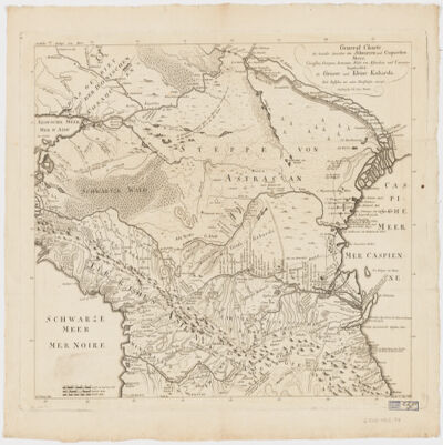
Nach Russischen und and Handschriften entworsen Strasburg bey Joh. Georg Treuttel ; I. P. Kremer delin ; B. F. Leizelt sc.Relief shown by hachures and pictorially.Prime meridian: Ferro.Includes ill.Map in German and French.Electronic reproduction. Cambridge, Mass. : Harvard College Library Digital Imaging Group, 2009. (Open Collections Program at Harvard University. Islamic Heritage Project). Copy digitized: Map Coll (Pusey) : MAP-LC G7060 1765 .T7.Electronic reproduction. Cambridge, Mass. : Harvard Geospatial Library, 2009. Georeferenced image for use in a GIS.
taʼlīf Ibrāhīm ibn Muḥammad ibn Aydamur al-ʻAlāʼī al-shahīr bi-Ibn Duqmāq.At head of title: Bibliothèque khédiviale.Arabic text in 2 parts, each of which has special t.p.Vol. 5 has a French t.p. and a preface in French signed Dr. Vollers.Vols. 4-5.تأليف إبراهيم بن محمد بن ايدمر العلائى الشهير بابن دقماق.Electronic reproduction. Cambridge, Mass. : Harvard College Library Digital Imaging Group, 2009. (Open Collections Program at Harvard University. Islamic Heritage Project). Copy digitized: Widener Library: Gibb 6506.103