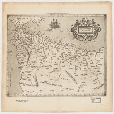
[Gerardus Mercator].Attributed to Mercator.Also covers a portion of Southern Spain.Relief shown pictorially.In an ornamental cartouche: "Medius meridianus J6, reliqui ad hunc inclinati funt pro ratione parallelorum 29 BL 34 ad circulum maximum."Probably originally published with a second map entitled "Africae II Tab." covering Malta, Sicily, Sardinia, Tunisia and Libya.Includes note and index on verso.Electronic reproduction. Cambridge, Mass. : Harvard College Library Digital Imaging Group, 2009. (Open Collections Program at Harvard University. Islamic Heritage Project). Copy digitized: Map Coll (Pusey) : MAP-LC G8220 1619 .A4.
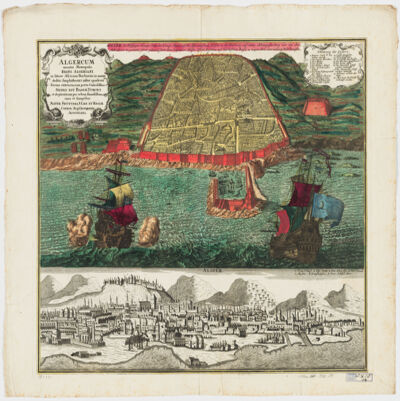
cura et sumptibus Matth. Seutteri.Birds-eye view.Appears in: Atlas novus sive tabulæ geographicæ totius orbis faciem, partes, imperia, regna et provincias exhibentes / exactissima cura iuxta recentissimas observation Matthaeo Seutter, [1745?]. Vol.1, map No. 137.Includes a close-up view of Algiers and index.In German with a title in Latin.Electronic reproduction. Cambridge, Mass. : Harvard College Library Digital Imaging Group, 2009. (Open Collections Program at Harvard University. Islamic Heritage Project). Copy digitized: Map Coll (Pusey) : MAP-LC G8244.A6 A3 1730 .S4.
cum interpretatione latina & notis Thomae Erpenii.In Arabic and Latin.Electronic reproduction. Cambridge, Mass. : Harvard College Library Digital Imaging Group, 2008. (Open Collections Program at Harvard University. Islamic Heritage Project).
dressée au Service géographique de l'armée.Covers also a portion of Algeria and Libya.Relief shown by shading and spot heights. Depth shown by isolines.In French with place names in Arabic and Latin in Latin script.Table of Contents: "Tunisie (800 000e) Flle Nord" -- "Tunisie (800 000e) Flle Sud".
dressée au Service géographique de l'armée.Covers also a portion of Algeria and Libya.Relief shown by shading and spot heights. Depth shown by isolines.In French with place names in Arabic and Latin in Latin script.Table of Contents: "Tunisie (800 000e) Flle Nord" -- "Tunisie (800 000e) Flle Sud".
dressée au Service géographique de l'armée.Covers also a portion of Algeria and Libya.Relief shown by shading and spot heights. Depth shown by isolines.In French with place names in Arabic and Latin in Latin script.Table of Contents: "Tunisie (800 000e) Flle Nord" -- "Tunisie (800 000e) Flle Sud".
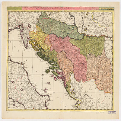
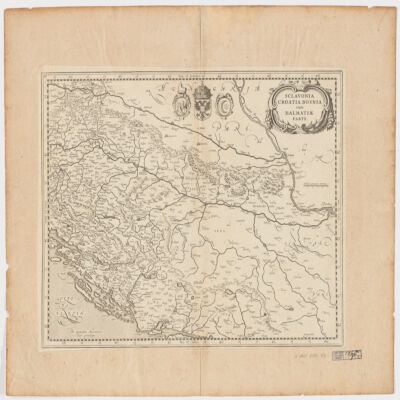
Venundantur per Gerardum et Leonardum Valk, cum Priv.Covers Croatia, Bosnia and Hercegovina, Serbia, Montenegro and portions of Italy, Albania, Greece, Macedonia and Hungary.Relief shown pictorially.Includes note.In Latin with place names in ItalianElectronic reproduction. Cambridge, Mass. : Harvard College Library Digital Imaging Group, 2009. (Open Collections Program at Harvard University. Islamic Heritage Project). Copy digitized: Map Coll (Pusey) MAP-LC G6800 1710 .V3.
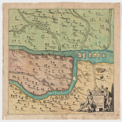
[Olfert Dapper].Covers a portion of southeastern Iraq where the Euphrates and the Tigris Rivers converge.Relief shown pictorially.From: Naukeurige beschryving van Asie: behelsende de gewesten van Mesopotamie, Babylonie, Assyrie, Anatolie, of Klein Asie: beneffens eene volkome beschrijving van gansch gelukkigh, woest, en petreesch of steenigh Arabie / Olfert Dapper. 1680.Oriented with North toward the left.Electronic reproduction. Cambridge, Mass. : Harvard College Library Digital Imaging Group, 2009. (Open Collections Program at Harvard University. Islamic Heritage Project). Copy digitized: Map Coll (Pusey) : MAP-LC G7610 1680 .D3.
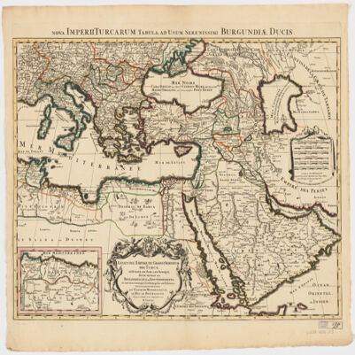
dressé sur les plus nouvelles relations a l'usage de Monseigneur le Duc de Bourgogne par son tres humble et tres obeissant serviteur H. Iaillot.Electronic reproduction. Cambridge, Mass. : Harvard College Library Digital Imaging Group, 2009. (Open Collections Program at Harvard University. Islamic Heritage Project). Copy digitized: Map Coll (Pusey) : MAP-LC G7430 1696 .J3.
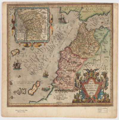
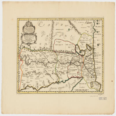
describebat Abrah. Ortelius.Covers Morocco and portions of Spain, West Sahara and Algeria.Relief shown pictorially and by hachures.Prime meridian: Ferro.Inset of West Africa: Congi Regni Christiani, in Africa, nova descriptio / Auctore Filippo Pigafetta (Scale [ca. 1:11,000,000]).Includes ill. in col.On verso: two texts entitled "Fessae et Marocchi Regna" and "Congi Regnum"."Cum Imp. Reg. et Brabantiæ privilegio decennali".Electronic reproduction. Cambridge, Mass. : Harvard College Library Digital Imaging Group, 2009. (Open Collections Program at Harvard University. Islamic Heritage Project). Copy digitized: Map Coll (Pusey) : MAP-LC G8230 1595 .O7.
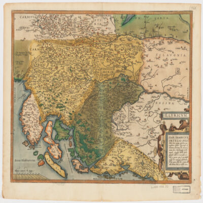
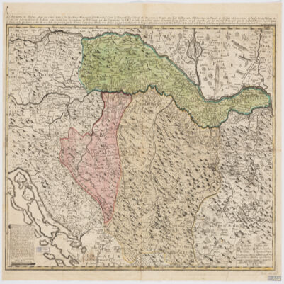
Ioan. Sambucus Ortelio suo, S Mitto hanc quòque tabellam qua nesessaria confinia Pannoniæ declarantur, fluviorum et aliquot locorum situs Hirschvogelii recte mutaui, Angelini autem studio plurima adieci, et inualla correxi, vt parum quis si cum Hirschvogelig hæc conjugat desiderarit si qui errores sint, dies certiora docebit.Covers Istria, Croatia, Slovenia, Bosnia and Herzegovina, Dalmatia, and part of Hungary.Relief shown pictorially."Cum temporaris et Regis Maiestaris Privilegio".Includes ill.On verso: text entitled "Illyricvm".
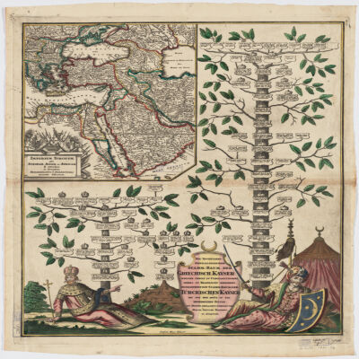
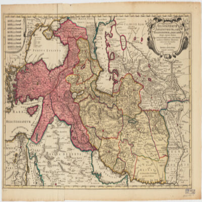
Covers Libya, Egypt, Sudan, the Arabian Peninsula, Lebanon, Syria, Iraq, Iran, the Balkan Peninsula, Turkey, Greece, Armenia, Azerbaijan and portions of Ethiopia and Russia.Relief shown by hachures and pictorially.Colored in outline.Inset: Neu Inventiert. Genealogischer Stamm-Baum Der Griechisch. Kaÿser Welche Theils Zu Constantinopel Theils Zu Trapezunt Residiret : desgleichen ein StammBaum Der Türckischen Kaÿser Bis Auf Den Heüt Zu Tag Regierenden Sultan / ins Kupfer gebracht u. verlegt von Matth. Seütter.Includes ill.In German and Latin.Electronic reproduction. Cambridge, Mass. : Harvard College Library Digital Imaging Group, 2009. (Open Collections Program at Harvard University. Islamic Heritage Project). Copy digitized: XXXXX Library: [call no.].
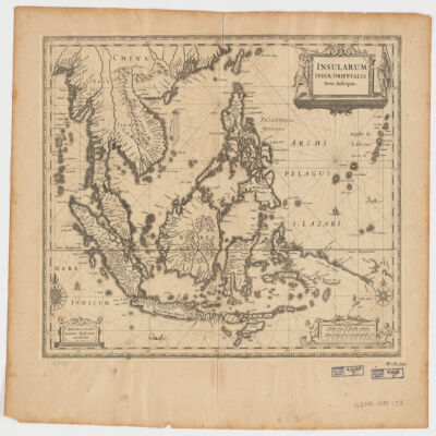
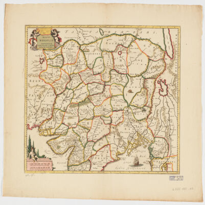
Ioannis Ianssonius.Covers Sumatra, Java, Borneo, Suwalesi, the Philippines, Papua New Guinea and portions of China, Burma and Malaysia.Relief shown pictorially.Includes ill.Electronic reproduction. Cambridge, Mass. : Harvard College Library Digital Imaging Group, 2009. (Open Collections Program at Harvard University. Islamic Heritage Project). Copy digitized: Map Coll (Pusey) : MAP-LC G8000 1650 .J3.Electronic reproduction. Cambridge, Mass. : Harvard Geospatial Library, 2009. Georeferenced image for use in a GIS.
cum interpretatione Latina & scholiis Iosephi Scaligeri et Thomæ Erpenii.Arabic title transliterated.BM 6:309 notes edited by Thomas Erpenius.Signatures: *⁴A-Q⁴ (Q4 blank, present).In Arabic and Latin.
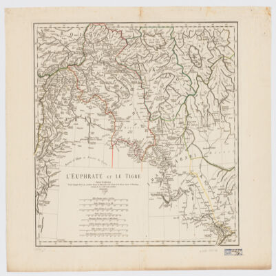
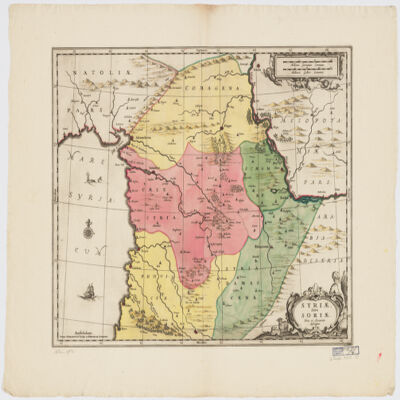
par le Sr. d'Anville ; Guill. De La Haye.Covers portions of Jordan, Syria, Lebanon, Israel, Turkey, Azerbaijan, Iran and Iraq.Relief shown pictorially.Colored in outline.In French with many place names also given with Roman-era Latin forms.Electronic reproduction. Cambridge, Mass. : Harvard College Library Digital Imaging Group, 2009. (Open Collections Program at Harvard University. Islamic Heritage Project). Copy digitized: XXXXX Library: [call no.].Electronic reproduction. Cambridge, Mass. : Harvard Geospatial Library, 2009. Georeferenced image for use in a GIS.
le très humble et très obéissant serviteur Étienne Briffaut.Shows battle places with date.Covers Bosnia and Hercegovina, and portions of Hungary, Croatia, Albania and Yugoslavia.Relief shown pictorially.Includes note and ill."Je me suis fais un devoir de Publier cette Carte Sous les Auspices de V. E. étant un des Capitaines de S.M.I. et Cath. qui entend mieux le métier de la guerre et qui marche sur les mêmes principes que le défunt Prince Eugène ayant le flême et la prudence come elle en a donné des preuves par les dernières campagnes d'Italie, et en dernier lieu par le combat contre les trouppes ottomanes arrivé le 28 7bris 737 près de la rivière de la Timock et suis avec un parfait dévouement et un pronfond respect de V. E.".In French with place names and a legend in Latin.Electronic reproduction. Cambridge, Mass. : Harvard College Library Digital Imaging Group, 2009. (Open Collections Program at Harvard University. Islamic Heritage Project). Copy digitized: XXXXX Library: [call no.].
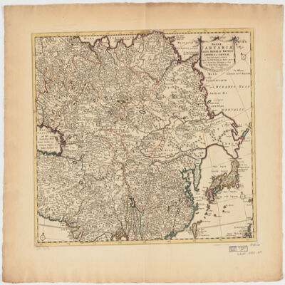
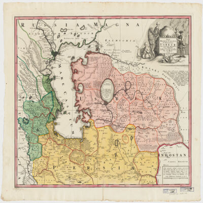
ampliss viri D. N. Witsen pro majori parte aliis auctoribus excerpta et dita per F. de Witt.Covers Northeastern Russia, China, Korea, Japan, Turkestan, Kazakhstan, Tajikistan, Kyrgyzstan, Mongolia, Uzbekistan, Afghanistan, Pakistan and portions of Iran, India, China.Relief shown pictorially.Colored in outline.Appears in: Atlas nouveau contenant toutes les parties du monde, où sont exactement marqués les empires, monarchies, royaumes, états républiques &c; le tout recueilli par les meilleurs géographes. [1683-1761]. Vol. 8, map no.108.In Latin with place names in Russian, Turkish, Persian and Arabic in Latin script.Electronic reproduction. Cambridge, Mass. : Harvard College Library Digital Imaging Group, 2009. (Open Collections Program at Harvard University. Islamic Heritage Project). Copy digitized: Map Coll (Pusey) : MAP-LC G7400 1725 .W5.
Per F. de Witt.Covers portions of the Middle East, South and Central Asia and China.Appears in: Atlas Major / Frederick de Wit. 1707. Map no. 118.Relief shown pictorially.Includes ill.Electronic reproduction. Cambridge, Mass. : Harvard College Library Digital Imaging Group, 2009. (Open Collections Program at Harvard University. Islamic Heritage Project). Copy digitized: Map Coll (Pusey) : MAP-LC G7625 1707 .W5.
delineatus a C. Niebuhr ; Defehrt sc..Covers the Red Sea Coast including parts of Djibouti.North oriented toward the right.Relief shown pictorially. Depths shown by shading.Includes index."Tab: XX".Electronic reproduction. Cambridge, Mass. : Harvard College Library Digital Imaging Group, 2009. (Open Collections Program at Harvard University. Islamic Heritage Project). Copy digitized: Map Coll (Pusey) : MAP-LC G5687.R3 1772 .N5.
li-Abī al-Qāsim Maḥmūd ibn ʻUmar al-Zamakhsharī.Title on added t.p.: Samachscharii lexicon arabicum persicum.لأبي القاسم محمود بن عمر الزمخشري.Electronic reproduction. Cambridge, Mass. : Harvard College Library Digital Imaging Group, 2009. (Open Collections Program at Harvard University. Islamic Heritage Project). Copy digitized: Widener Library: OL 22423.9.
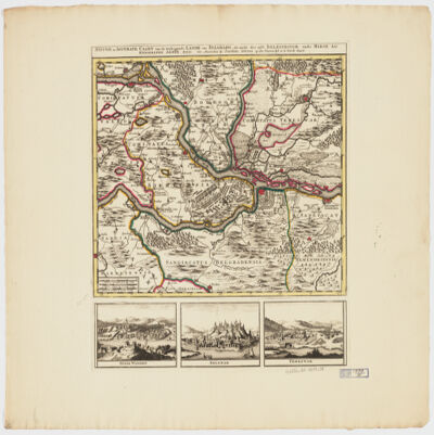
by Joachim Ottens.Relief shown pictorially.Colored in outline.Shows military points of interest related to the Battle of Belgrade, 1717.Includes ill. and views: Peter Wardein -- Belgrad -- Temeswar.Place names in Latin.Electronic reproduction. Cambridge, Mass. : Harvard College Library Digital Imaging Group, 2009. (Open Collections Program at Harvard University. Islamic Heritage Project). Copy digitized: Map Coll (Pusey) MAP-LC G6854.B5 1717 .O8.
in qua itinera Regia et alia notabiliora accurate denotantur per A. Maas ; reductio mappæ haijus a majore in hanc monirem formam facta est per Iohannem Petrum van Ghelen.Covers portions of Uzbekistan, Kazakhstan, Afghanistan, Turkmenistan, Russia, Azerbaijan and Iran.Relief shown pictorially. Depth shown by soundings.Includes notes and ill."Cum Priv. S. C. M.".Electronic reproduction. Cambridge, Mass. : Harvard College Library Digital Imaging Group, 2009. (Open Collections Program at Harvard University. Islamic Heritage Project). Copy digitized: Map Coll (Pusey) : MAP-LC G5692.C3 1735 .M3.
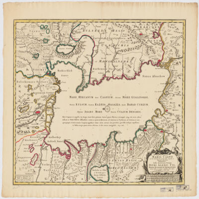
immenso labore et maximis sumptibus facta, atque ex autographo in lucem edita per Reinerum Ottens geographum Amstelaedam ; Iacob Keyser sculp.Covers portions of Iran, Turkmenistan, Kazakhstan, Russia and Azerbaijan.Relief shown pictorially. Depth shown by soundings.Oriented with North to the left.Colored in outline.Includes ill.Appears in: Atlas maior cum generales omnium totius orbis regnorum rerumpubl. atque insularum tum particulares praecipuarum in iis provinciarum ducatuum comitatuum ceterarum que minorum regionum ac divisionum tabulas geographicas continens ex optimis ac novissimis quibusque variorum autorum tabulis collectus et eleganti ordine dispositus / Reiner Ottens. [1641-1729]. Vol. 7, map No. 23.In Latin with a publication note in Dutch and place names in Greek, Russian, Persian, Arabic, and Turkish in Latin script.Electronic reproduction. Cambridge, Mass. : Harvard College Library Digital Imaging Group, 2009. (Open Collections Program at Harvard University. Islamic Heritage Project). Copy digitized: XXXXX Library: [call no.].
par E. Andriveau ; gravé le trait et les montagnes par Gérin, les écritures par P. Rousset, les eaux par Mme Fontaine.Covers portions of Israel, Jordan, Syria and Lebanon.Relief shown by hachures. Depth shown by sounding and isolines.Insets: [Sinai] (Scale [ca. 1:2,600,000]) -- Golfe de Suez -- [Cross section of the Palestine from the source of the Jordan to the Red Sea] -- [Panoramic view of the mountains of Palestine] -- Jérusalem d'après le plan de G. Williams (Scale [ca. 1:80,000])."No. 18"."Atlas usuel No. 23"."Atlas universel No.36".Includes notes and index.In French with place names in Latin, Arabic and Hebrew in Latin script.Electronic reproduction. Cambridge, Mass. : Harvard Geospatial Library, 2009. Georeferenced image for use in a GIS.
cum triplici versione Latina, & scholijs Thomae Erpenii, cujus & alphabetum Arabicum praemittitur.Signatures: A-S⁴ (signatures printed in Arabic sequence).Title and imprint within an architectural woodcut border incorporating the printer's device; printer's device at end.Interlinear word-for-word translation, with a free marginal translation by Erpenius, followed by the version of Robert of Chester and Hermannus Dalmata, and notes.In Arabic and Latin.cum triplici versione Latina, & scholijs Thomae Erpenii, cujus & alphabetvm Arabicvm praemittitur.Electronic resource. Leiden : IDC, 2010. (Early Western Korans ; EPK-18)Electronic reproduction. Cambridge, Mass. : Harvard College Library Digital Imaging Group, 2008. (Open Collections Program at Harvard University. Islamic Heritage Project).
ex variis observationibus in lucem edita a Reinero et Josua Ottens.Covers the Middle East, Southern Caucasus, Central Asia and portions of Egypt, the Arabian Peninsula and Southeastern Europe.Relief shown pictorially.Electronic reproduction. Cambridge, Mass. : Harvard College Library Digital Imaging Group, 2009. (Open Collections Program at Harvard University. Islamic Heritage Project). Copy digitized: Map Coll (Pusey) : MAP-LC G7420 1730 .R2.
per Gerardum Mercatorem cum privilegio.Apperas in: Nieuwen atlas ofte werelt-beschrijvinge vertoonende de voornaemste rijckenende lande des gheheelen aerdt-bodems / Ioannem Ianssonium. 1657-[87]. Vol. 1, map No. 138.Covers Slovenia, Croatia, Bosnia and Hercegovina and portions of Hungary, Serbia and Montenegro.Relief shown pictorially.Includes coats of arms.Electronic reproduction. Cambridge, Mass. : Harvard College Library Digital Imaging Group, 2009. (Open Collections Program at Harvard University. Islamic Heritage Project). Copy digitized: Map Coll (Pusey) : MAP-LC G6800 1630 .M4.
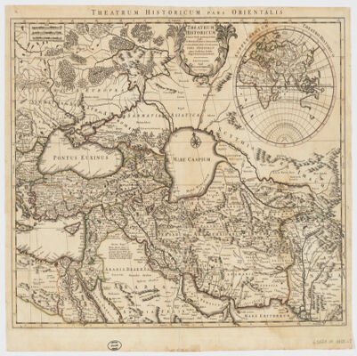
Auctore Guillelmo Delisle.Covers the Middle East, Southeastern Europe and portions of Russia, Egypt, India and the Arabian Peninsula."100."Colored in outline.Inset map: Supplementum theatro historico.Relief shown pictorially.Engraved on woven paper.Includes note.Electronic reproduction. Cambridge, Mass. : Harvard College Library Digital Imaging Group, 2009. (Open Collections Program at Harvard University. Islamic Heritage Project). Copy digitized: Map Coll (Pusey) : MAP-LC G5671.S1 1759 .L5.
ex novissimis subsidiis ac relationibus ad normam legitimae proiectionis in usum belli praesentis delineata impensis homannianorum heredum.Covers Eastern Turkey, Cyprus, Syria, Lebanon, Israel, Jordan, Iraq, Armenia, Azerbaijan, Georgia and portions of Egypt, the Arabian Peninsula, Iran, Greece and Russia.Relief shown pictorially.In Latin with a title in French.Electronic reproduction. Cambridge, Mass. : Harvard Geospatial Library, 2009. Georeferenced image for use in a GIS.Electronic reproduction. Cambridge, Mass. : Harvard College Library Digital Imaging Group, 2009. (Open Collections Program at Harvard University. Islamic Heritage Project). Copy digitized: Map Coll (Pusey) : MAP-LC G7420 1771 .H6.
arabicè olim exarata à Georgio Elmacino ... et latinè reddita operâ ac studio Thomae Erpenii. Accedit & Roderici Ximenez ... Historia Arabum, longè accuratius, quam antè, è manuscripto codice expressa.Arabic text and Latin translation in parallel columns.Electronic reproduction. Cambridge, Mass. : Harvard College Library Digital Imaging Group, 2008. (Open Collections Program at Harvard University. Islamic Heritage Project).
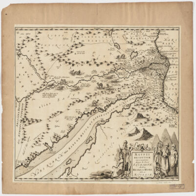
Covers Egypt and portions of Libya, Israel and Jordan, including the Red Sea and the Nile.Relief shown pictorially.Oriented with North to the right.Includes ill.Appears in: Nieuwen atlas ofte werelt-beschrijvinge vertoonende de voornaemste rijckenende landen des gheheelen aerdt-bodems; vermeerdert met veel schoone landt-kaerten, nieuwelijcks uptgegeven (...) / Ioannem Iansonium, 1657-87. Vol. 3, map No. 96.In Latin with place names in Hebrew and Arabic in Latin script.
authore P. Duval Abbeviliense Regis Christianissimi geographo.Shows political divisions.Covers also a portion of Libya.Relief shown pictorially.Oriented with North to the right.Includes a note in a decorative cartouche: "A Monsieur Monsieur Doviat Sgr. de Montreuille, Con.er du Roy, et Maistre Ordinaire en sa Chambre des Comptes Par son Très humble et obéisant Serviteur P. Duval Géographe de sa Maiesté".In Latin with a note in French.Electronic reproduction. Cambridge, Mass. : Harvard College Library Digital Imaging Group, 2009. (Open Collections Program at Harvard University. Islamic Heritage Project). Copy digitized: Map Coll (Pusey) : MAP-LC G8300 1652 .D8.