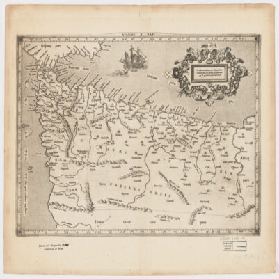
1. Africae I Tab Creator: Mercator, Gerhard, 1512-1594 (المنشئ) Date: Date Issued: 1619?] Language: Latin Geographic region: Place of Production: xx, No place, unknown, or undetermined, [S.lAfrica, North Extent: 1 map ; 31 x 45 cm.
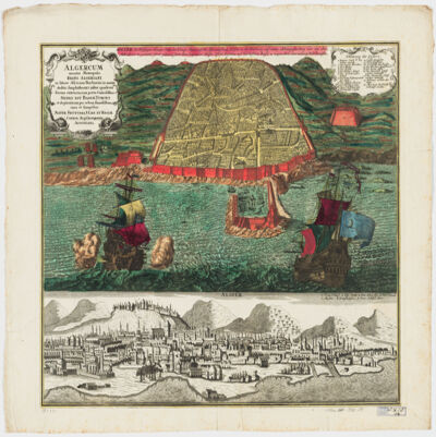
2. Algercum munita metropolis Regni Algeriani : in littore Africano Barbariæ in monte declivi Amphitheatri instar quadrata forma extructa, cum portu Commodissimo Sedes est Bassæ Turcici et ob piraticam per orbem famosissima =Algier die Befestigte Haupt-Statt des Königr. Algier, Auf die Africanischen Küsten in der Barbarey auf einem abhängigen Berg wie ein Amphiteatrum in gevierten form gebauet samt dem bequemen hasen. Ift die Residenz des Türkischen Bassa u: wegen ihrer Secrauberey Welt berussen Creator: Seutter, Matthaeus, 1678-1756 (المنشئ) Date: Date Issued: [1730?] Language: GermanLatin Geographic region: Place of Production: au, Austria, AugustaniAlgiers (Algeria) Extent: 1 view : hand col. ; 48 x 56 cm.
3. Amthāl Luqmān al-Ḥakīm wa-baʻḍ aqwāl al-ʻArab =Locmani Sapientis Fabulae et selecta quaedam Arabum adagia Creator: Luqmān, the Sage (المنشئ) Date: Date Issued: 1615 Language: ArabicLatin Geographic region: Place of Production: ne, Netherlands, Leidae Extent: [16], 78, [1] p. ; 16 cm.
4. Carte de la Tunisie Creator: Institut géographique national (France) (Creator) Date: Date Issued: 1895 Language: FrenchArabicLatin Geographic region: Place of Production: fr, France, ParisTunisia Extent: 1 map on 2 sheets : col. ; 110 x 65 cm., sheet 58 x 71 cm.
5. Carte de la Tunisie Creator: Institut géographique national (France) (Creator) Date: Date Issued: 1895 Language: FrenchArabicLatin Geographic region: Place of Production: fr, France, ParisTunisia Extent: 1 map on 2 sheets : col. ; 110 x 65 cm., sheet 58 x 71 cm.
6. Carte de la Tunisie Creator: Institut géographique national (France) (Creator) Date: Date Issued: 1895 Language: FrenchArabicLatin Geographic region: Place of Production: fr, France, ParisTunisia Extent: 1 map on 2 sheets : col. ; 110 x 65 cm., sheet 58 x 71 cm.
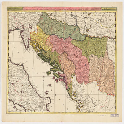
7. Dalmatia, Sclavonia, Croatia, Bosnia, Servia, et Istriadistributa in singulares ditiones et diœceses, una cum Republica Ragusana, et circumjacentibus regionibus, Hungaria, Venetiis, statu ecclesiastico, Napoli et Macedonia Creator: Valck, G. (Gerard), 1651-1726 (Creator) Date: Date Issued: [1710?] Language: LatinItalian Geographic region: Place of Production: ne, Netherlands, [Amsterdam]Balkan PeninsulaAdriatic Coast (Balkan Peninsula)Adriatic Coast (Italy) Extent: 1 map : hand col. ; 45 x 57 cm.
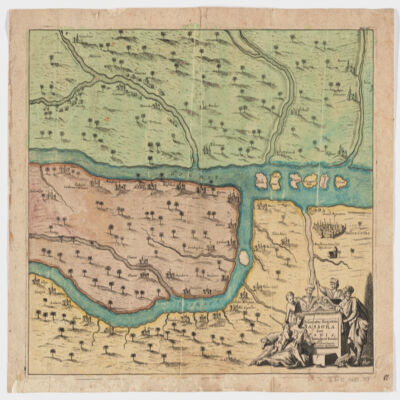
8. Delineatio regionis Bassora cum pagis fluminibus et insulis, quæ christiani sancti Ioannis incolunt Creator: Dapper, Olfert, 1635 or 1636-1689 (المنشئ) Date: Date Issued: 1680?] Language: Latin Geographic region: Place of Production: ne, Netherlands, [AmsterdamIraqBaṣrah Region (Iraq) Extent: 1 map : hand col. ; 29 x 36 cm.
9. Estats de l'Empire du grand Seigneur des Turcs en Europe, en Asie, et en Afriquedivisé en tous ses Beglerbeglicz ou Gouvernements; où sont aussi remarqués les Estats qui luy sont Tributaires Creator: Jaillot, Alexis Hubert, 1632?-1712 (المنشئ) Date: Date Issued: 1696 Language: Latin Geographic region: Place of Production: fr, France, ParisTurkeyMiddle EastAfrica, NorthEurope, SouthernNorth AfricaSouthern Europe Time period: Ottoman Empire, 1288-1918 Extent: 1 map : hand colored ; 44 x 60 cm
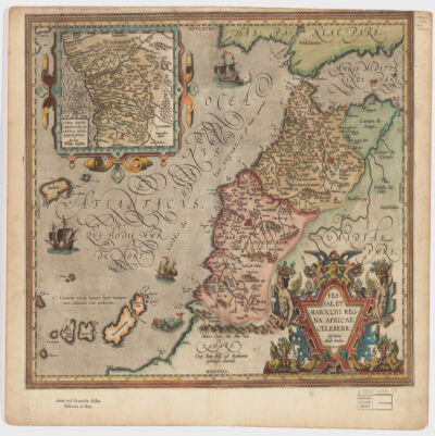
10. Fessae, et Marocchi Regna Africae celeberr Creator: Ortelius, Abraham, 1527-1598 (المنشئ) Date: Date Issued: 1595 Language: Latin Geographic region: Place of Production: be, Belgium, [Antwerp]MoroccoGibraltar, Strait ofCanary Islands Extent: 1 map : hand col. ; 37 x 48 cm.
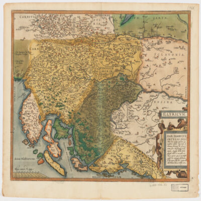
11. Illyricvm Creator: Zsámboki, János, 1531-1584 (المنشئ) Date: Date Issued: Oct. 25, 1572 Language: Latin Geographic region: Place of Production: au, Austria, ViennæBalkan PeninsulaSloveniaCroatiaBosnia and Herzegovina Extent: 1 map : hand col. ; 36 x 46 cm.
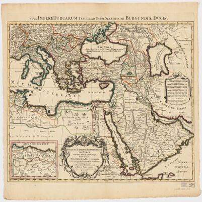
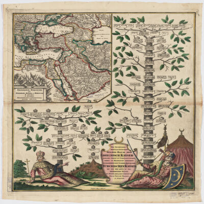
12. Imperium Turcicum per Europam, Asiam Et Africam se extendens et secundum Beglerbegatus sive Praefecturas accurate distinctum Creator: Seutter, Matthaeus, 1678-1756 (المنشئ) Date: Date Issued: [1720?] Language: GermanLatin Geographic region: Place of Production: gw, Germany, AugspurgTurkeyIslamic countries Extent: 1 map : hand col. ; 27 x 25 cm., on sheet 61 x 52 cm.
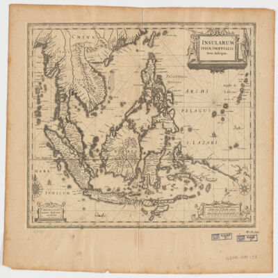
13. Insularum Indiae Orientalisnova descriptio Creator: Jansson, Jan, 1588-1664 (المنشئ) Date: Date Issued: [1650?] Language: Latin Geographic region: Place of Production: ne, Netherlands, AmstelodamiSoutheast AsiaEast Indies Extent: 1 map ; 37 x 48 cm.
14. Kitab al-amthal =seu proverbiorum Arabicorum centuriæ duæ : ab anonymo quodam Arabe collectæ & explicatæ Creator: Erpenius, Thomas, 1584-1624 (المنشئ) Date: Date Issued: 1614 Language: LatinArabic Geographic region: Place of Production: ne, Netherlands, Leidæ Extent: [8], 126 p. ; 21 cm. (4to).
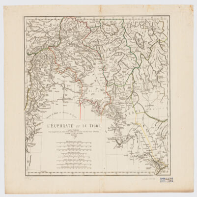
15. L' Euphrate et le Tigre Creator: Anville, Jean Baptiste Bourguignon d', 1697-1782 (المنشئ) Date: Date Issued: 1779 Language: FrenchLatin Geographic region: Place of Production: fr, France, [ParisEuphrates RiverTigris RiverIraqSyriaTurkey Extent: 1 map : hand col. ; 42 x 51 cm.
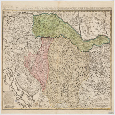
16. Le Royaume de Bosnie, dans son entier, dédié a son Excellence Monseignr. le feld Maréchal Comte de Khewenhüller Colonel d'un Régiment de Dragon Vice Roy d'Esclavonie, du Duché de Syrmie et Gouverneur de la Forteresse d'Essegg etc Creator: Briffaut, Étienne. (المنشئ) Date: Date Issued: 1740 Language: FrenchLatin Geographic region: Place of Production: fr, France, VienneBosnia and HerzegovinaCroatia Extent: 1 map : hand col. ; 60 x 90 cm.
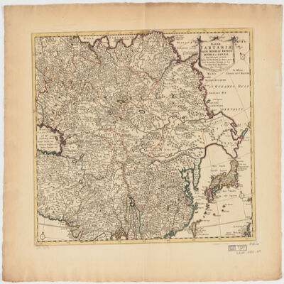
17. Magnae Tartariae, magni Mogolis Imperii, Iaponiae et Chinaenova descriptio ex tabula Creator: Wit, Frederik de. (المنشئ) Date: Date Issued: [ca. 1725?] Language: Latin Geographic region: Place of Production: ne, Netherlands, AmstelodamiAsia Extent: 1 map : hand col. ; 41 x 52 cm.
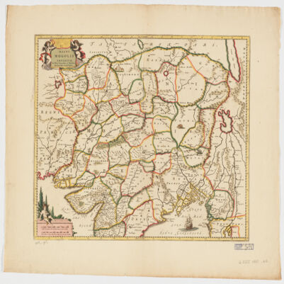
18. Magni Mogolis Imperium de novo correctum et divisum Creator: Wit, Frederik de. (المنشئ) Date: Date Issued: [1707?] Language: Latin Geographic region: Place of Production: ne, Netherlands, AmstelodamiMogul EmpireSouth AsiaAsia, Central Extent: 1 map : hand col. 40 x 50 cm.
19. Mare Rubrum seu Sinus Arabicusad observationes maximam partem ab Auctore annis MDCCLXII et MDCCLXIII institutas Creator: Niebuhr, C. (المنشئ) Date: Date Issued: 1772 Language: Latin Geographic region: Place of Production: xx, No place, unknown, or undetermined, HafniaeRed Sea RegionRed Sea Coast (Saudi Arabia)Red Sea Coast (Egypt)Red Sea Coast (Yemen)Red Sea Coast (Jordan) Extent: 1 map ; 78 x 21 cm.
20. Muqaddimat al-adab Creator: Zamakhsharī, Maḥmūd ibn ʻUmar, 1075-1144 (المنشئ) Date: Date Issued: 1843Date Issued: 1843. Language: ArabicLatin Geographic region: Place of Production: gw, Germany, Libsīyā Extent: 300, 269 p. ; 29 cm.