Number of results to display per page
Search Results

21. Africa, 1815 (Raster Image)
- Description:
- This layer is a georeferenced raster image of the historic paper map entitled: Smith's new map of Africa : comprising the most recent researches, Picket sculpt. It was printed for C. Smith, Mapseller and Publisher in Jany. 6th, 1815. Scale [ca. 1:12,000,000]. Covers also a small portion of Europe and the Middle East. The image inside the map neatline is georeferenced to the surface of the earth and fit to the Africa Sinusoidal projected coordinate system. All map collar and inset information is also available as part of the raster image, including any inset maps, profiles, statistical tables, directories, text, illustrations, index maps, legends, or other information associated with the principal map. This map shows features such as drainage, cities and other human settlements, territorial boundaries, roads, shoreline features, and more. Relief shown by hachures. This layer is part of a selection of digitally scanned and georeferenced historic maps from the Harvard Map Collection. These maps typically portray both natural and manmade features. The selection represents a range of originators, ground condition dates, scales, and map purposes.Historic paper maps can provide an excellent view of the changes that have occurred in the cultural and physical landscape. The wide range of information provided on these maps make them useful in the study of historic geography, and urban and rural land use change. As this map has been georeferenced, it can be used in a GIS as a source or background layer in conjunction with other GIS data.None planned
22. Africa, 1834 (Raster Image)
- Description:
- This layer is a georeferenced raster image of the historic paper map entitled: Carte détaillée (en deux feuilles), de l'Afrique et des îles qui en dependent (partie septentrionale), par A. Broué, Géographe du Roi, d'après les observations astronomiques, les découvertes et les hypothèses les plus récentes. Revue en 1834. It was published by Chez l'Auteur in 1828, i.e. 1834. Scale [ca. 1:16,250,000]. Covers Africa and a small portion of Europe and the Middle East. Map in French.The image inside the map neatline is georeferenced to the surface of the earth and fit to the Africa Sinusoidal projected coordinate system. All map collar and inset information is also available as part of the raster image, including any inset maps, profiles, statistical tables, directories, text, illustrations, index maps, legends, or other information associated with the principal map. This map shows features such as drainage, cities and other human settlements, territorial boundaries, roads, mines, shoreline features, and more. Relief shown by hachures. Includes notes and insets: Extrémité Sud de l'Afrique, ou Colonie du Cap, Pays des Hottentots et Betjouanas; Archipel du Nord-Est de Madagascar; Abyssinie et Pays des Gallas, etc.This layer is part of a selection of digitally scanned and georeferenced historic maps from the Harvard Map Collection. These maps typically portray both natural and manmade features. The selection represents a range of originators, ground condition dates, scales, and map purposes.Historic paper maps can provide an excellent view of the changes that have occurred in the cultural and physical landscape. The wide range of information provided on these maps make them useful in the study of historic geography, and urban and rural land use change. As this map has been georeferenced, it can be used in a GIS as a source or background layer in conjunction with other GIS data.None planned
23. Africa, 1890 (Raster Image)
- Description:
- This layer is a georeferenced raster image of the historic paper map entitled: Afrique : d'apres les documents les plus recents et les derniers traites, dressee par E. Giffault ; grave et imp. par Erhard Fres. It was published by Le Temps Bureaux in 1890. Scale 1:18,000,000. Map in French.The image inside the map neatline is georeferenced to the surface of the earth and fit to a non-standard 'World Sinusoidal' projection with the central meridian at 20 degrees east. All map collar and inset information is also available as part of the raster image, including any inset maps, profiles, statistical tables, directories, text, illustrations, index maps, legends, or other information associated with the principal map. This map shows features such as drainage, roads, caravan routes, cities and other human settlements, territorial boundaries, colonial possessions, and more. Relief is shown by hachures and spot heights. This layer is part of a selection of digitally scanned and georeferenced historic maps from the Harvard Map Collection and the Harvard University Library as part of the Open Collections Program at Harvard University project: Organizing Our World: Sponsored Exploration and Scientific Discovery in the Modern Age. Maps selected for the project correspond to various expeditions and represent a range of regions, originators, ground condition dates, scales, and purposes.Historic paper maps can provide an excellent view of the changes that have occurred in the cultural and physical landscape. The wide range of information provided on these maps make them useful in the study of historic geography, and urban and rural land use change. As this map has been georeferenced, it can be used in a GIS as a source or background layer in conjunction with other GIS data.None planned
24. Africa, Catholic Missions and Colonial Possessions, 1889 (Raster Image)
- Description:
- This layer is a georeferenced raster image of the historic paper map entitled: Tiré de l'ouvrage les missions catholiques d'Afrique en 1889, par le Baron Léon Bethune. It was published by Société de St. Augustin in 1889. Scale 1:20,000,000. Map in French.The image inside the map neatline is georeferenced to the surface of the earth and fit to a non-standard 'World Sinusoidal' projection with the central meridian at 20 degrees east. All map collar and inset information is also available as part of the raster image, including any inset maps, profiles, statistical tables, directories, text, illustrations, index maps, legends, or other information associated with the principal map. This map shows features such as drainage, cities and other human settlements, colonial possessions, ecclesiastical districts, and more. Relief is shown by hachures. Includes index.This layer is part of a selection of digitally scanned and georeferenced historic maps from the Harvard Map Collection and the Harvard University Library as part of the Open Collections Program at Harvard University project: Organizing Our World: Sponsored Exploration and Scientific Discovery in the Modern Age. Maps selected for the project correspond to various expeditions and represent a range of regions, originators, ground condition dates, scales, and purposes.Historic paper maps can provide an excellent view of the changes that have occurred in the cultural and physical landscape. The wide range of information provided on these maps make them useful in the study of historic geography, and urban and rural land use change. As this map has been georeferenced, it can be used in a GIS as a source or background layer in conjunction with other GIS data.None planned
25. Africa, ca. 1680-1689 (Raster Image)
- Description:
- This layer is a georeferenced raster image of the historic paper map entitled: Africa : divisa in suas principales partes, nempè : imperia, monarchias, regna, principatus, et insulas, per Sr. Sansonium, geographum Regis Galliae ordinarium ; [cartouche] Sigmund Gabriel Hipschmann scul. It was published by Johannem Hoffmannum between 1680 and 1689. Scale [ca. 1:16,500,000]. Covers Africa and small portions of southern Europe, the Middle East, and South America. Map in Latin.The image inside the map neatline is georeferenced to the surface of the earth and fit to the Africa Sinusoidal projected coordinate system. All map collar and inset information is also available as part of the raster image, including any inset maps, profiles, statistical tables, directories, text, illustrations, index maps, legends, or other information associated with the principal map. This map shows features such as drainage, cities and other human settlements, roads, shoreline features, and more. Relief shown pictorially.This layer is part of a selection of digitally scanned and georeferenced historic maps from the Harvard Map Collection. These maps typically portray both natural and manmade features. The selection represents a range of originators, ground condition dates, scales, and map purposes.Historic paper maps can provide an excellent view of the changes that have occurred in the cultural and physical landscape. The wide range of information provided on these maps make them useful in the study of historic geography, and urban and rural land use change. As this map has been georeferenced, it can be used in a GIS as a source or background layer in conjunction with other GIS data.None planned
26. Africa, ca. 1725 (Raster Image)
- Description:
- This layer is a georeferenced raster image of the historic paper map entitled: Africa vetus, autore N. Sanson. It was published by J. Cóvens & C. Mortier ca. 1725. Scale [ca. 1:25,000,000]. Covers Africa and small portions of Europe and the Middle East. Map in Latin. The image inside the map neatline is georeferenced to the surface of the earth and fit to the Africa Sinusoidal projected coordinate system. All map collar and inset information is also available as part of the raster image, including any inset maps, profiles, statistical tables, directories, text, illustrations, index maps, legends, or other information associated with the principal map. This map shows features such as drainage, cities and other human settlements, territorial boundaries, shoreline features, and more. Relief shown pictorially. This layer is part of a selection of digitally scanned and georeferenced historic maps from the Harvard Map Collection. These maps typically portray both natural and manmade features. The selection represents a range of originators, ground condition dates, scales, and map purposes.Historic paper maps can provide an excellent view of the changes that have occurred in the cultural and physical landscape. The wide range of information provided on these maps make them useful in the study of historic geography, and urban and rural land use change. As this map has been georeferenced, it can be used in a GIS as a source or background layer in conjunction with other GIS data.None planned
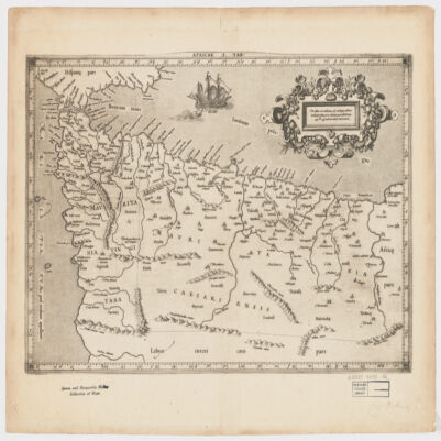
27. Africae I Tab
- Description:
- [Gerardus Mercator].Attributed to Mercator.Also covers a portion of Southern Spain.Relief shown pictorially.In an ornamental cartouche: "Medius meridianus J6, reliqui ad hunc inclinati funt pro ratione parallelorum 29 BL 34 ad circulum maximum."Probably originally published with a second map entitled "Africae II Tab." covering Malta, Sicily, Sardinia, Tunisia and Libya.Includes note and index on verso.Electronic reproduction. Cambridge, Mass. : Harvard College Library Digital Imaging Group, 2009. (Open Collections Program at Harvard University. Islamic Heritage Project). Copy digitized: Map Coll (Pusey) : MAP-LC G8220 1619 .A4.
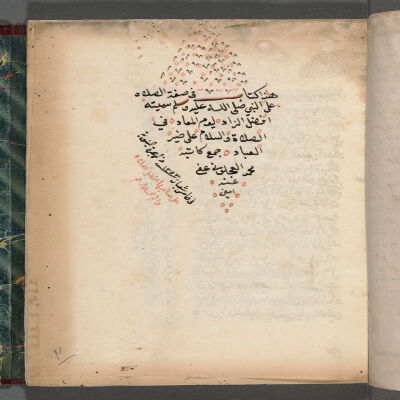
28. Afḍal al-zād li-yawm al-maʻād fī al-ṣalāh wa-al-salām ʻalá khayr al-ʻibād
- Description:
- Holograph copy, completed on 5 Shaʻbān 1253 AH [November 4, 1837 AD] according to colophon (f. 28v).The mss is later owned by the author's son Aḥmad Abū al-Fatḥ al-ʻAjlūnī. Ownership statement, dated Rabīʻ al-Awwal, [12]87 AH [1870]. Seal reads Aḥmad Abū al-Fatḥ, 1280 AH [1863/4 AD] (f. 1r).Written in one column, 20 lines per page, in black and red. Catchwords and comments in the margins.MS Arab SM7087. Houghton Library, Harvard University.In Arabic.Table of Contents: 1- al-Durrah al-zāhirah bi-taḍmīn al-Burʼah al-fājirah / lil-Shaykh Qāsim (printed text, paginated 1-15; ff. 1r-8r) -- 2. Afḍal al-zād li-yawm al-maʻād fī al-ṣalāh wa-al-salām ʻalá khayr al-ʻibād (ff. 9r-28v) -- 3. On miracles of the Prophet (ff. 29r-32r) -- 4. Commentary on a verse from the Qurʼān (ff. 32v-34v) -- 5. Hādhihi Qaṣīdat Sayyidinā Muḥammad [A poem in praise of the Prophet] (f. 35r) -- 6. Hādhā Mawlid Sayyid al-awwalīn wa-al-ākhirīn Muḥammad ibn ʻAbd Allāh ibn ʻAbd al-Muṭṭalib, 25 Rabīʻ al-Awwal 1274 AH [November 12, 1857 AD] (ff. 36r-40v).
29. Ahkam-i mer'iye
- Description:
- [katabahu al-faqīr Aḥmad ʻĀrif Ḥikmat ibn Ibrāhīm ʻIṣmat al-Ḥusaynī].In Ottoman Turkish.[كتبه الفقير احمد عارف حكمت بن ابراهيم عصمت الحسيني].Electronic reproduction. Cambridge, Mass. : Harvard College Library Digital Imaging Group, 2009. (Open Collections Program at Harvard University. Islamic Heritage Project). Copy digitized: Harvard Law School Library: Rare TUR 315 G51.
30. Ahlâk-ı alâ'î : manuscript, undated
- Description:
- A work on morals, completed on 25 Safer 973 AH [21 Sept. 1565 AD], while the author was serving as judge in Damascus. First section is on personnal morals, second on family morals and third on political morals and art of governance.Unbound. Missing leaves at the beginning and at the end.25.2 x 14.2 cm (17.3 x 8 cm).بعض مأيل بخير وبعض بشر... :f. 1rآداب مستحسنه دن امتناع ايله وهيج. :f. 279vWritten in naskh script, in one column, 25 lines per page, in black rubricated in red, framed in gold and black. Poems in two columns. Qurʼanic verses and important names in red or red overlined. Occasional red ornamental punctuation marks within text. Also green marks in first pages. Occasional corrections in margins.Light-cream laid paper. No binding. Some pages stuck together due to humidity.MS Turk 28. Houghton Library, Harvard University.In Ottoman Turkish.Electronic reproduction. Cambridge, Mass. : Harvard College Library Digital Imaging Group, 2008. (Open Collections Program at Harvard University. Islamic Heritage Project).