1. 5 grañth ne 100 ginān bhāj 2 jo Creator: Pīr Imām Shāh, 1430-1512 (المنشئ) Date: Date Issued: 1903 Language: Indic languages Geographic region: Place of Production: ii, India, Bombay Extent: 243 p. : ill. ; 23 cm.
2. 100 ginānjī ćopaḍī ćogaḍīevārī Creator: Pīr Ṣadr ad-Dīn, active 14th century (المنشئ) Date: Date Issued: 1903 Language: Indic languages Geographic region: Place of Production: ii, India, Bombay Extent: 133 p. : ill. ; 24 cm.
3. 100 ginānjī:ćopaḍī:ćogaḍīe:vārī Creator: Pīr Ṣadr ad-Dīn, active 14th century (المنشئ) Date: Date Issued: 1890 Language: Indic languages Geographic region: Place of Production: ii, India, Bombay Extent: 184 p. ; 24 cm.
4. 100:ginānjī:ćopaḍī:cālû:ginān:āgal:na:ćhapāela:bhāg:trījo Creator: Pīr Imām Shāh, 1430-1512 (المنشئ) Date: Date Issued: 1903 Language: Indic languages Geographic region: Place of Production: ii, India, Bombay Extent: 151 p. ; ill. ; 23 cm.
5. A collection of Turkish and Persian poetry : manuscript, undated Language: Turkish, Ottoman (1500-1928)Persian Geographic region: Place of Production: xx, No place, unknown, or undetermined Extent: 28 leaves, bound ; 20 cm.
6. A collection of Turkish poetry : manuscript, undated Language: Turkish, Ottoman (1500-1928) Geographic region: Place of Production: tu, Turkey Extent: 1 v. (109 leaves) ; 25 cm.
7. A generall mapp of the Coast of Barbarie, where in are the Kingdoms, and Estates of Morocco, Fez, Algiers, Tunis and Tripolialso the Kingdoms, Estates and Deserts of Barca, Egipt, Libya, Biledulgerid, Segelmesse and Darha: with the circumjacent counteries Creator: Sanson, Nicolas, 1600-1667 (المنشئ) Date: Date Issued: 1667?] Language: EnglishFrench Geographic region: Place of Production: enk, England, [LondonMoroccoTunisiaAlgeriaMauritania Extent: 1 map on 2 sheets ; 28 x 106 cm, sheets 35 x 57 cm and 35 x 59 cm.
8. A generall mapp of the Coast of Barbarie, where in are the Kingdoms, and Estates of Morocco, Fez, Algiers, Tunis and Tripolialso the Kingdoms, Estates and Deserts of Barca, Egipt, Libya, Biledulgerid, Segelmesse and Darha: with the circumjacent counteries Creator: Sanson, Nicolas, 1600-1667 (المنشئ) Date: Date Issued: 1667?] Language: EnglishFrench Geographic region: Place of Production: enk, England, [LondonMoroccoTunisiaAlgeriaMauritania Extent: 1 map on 2 sheets ; 28 x 106 cm, sheets 35 x 57 cm and 35 x 59 cm.
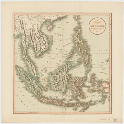
9. A new map of the East India Islesfrom the latest authorities Creator: Cary, John, approximately 1754-1835 (المنشئ) Date: Date Issued: Dec. 21, 1801 Language: English Geographic region: Place of Production: enk, England, LondonSoutheast AsiaEast IndiesIndonesiaMalay PeninsulaIndochinaPhilippines Extent: 1 map : hand col. ; 44 x 50 cm.
10. Abḥāth al-mulakhkhaṣah fī ḥukm kayy al-ḥimmaṣah Creator: Nābulusī, ʻAbd al-Ghanī ibn Ismāʻīl, 1641-1731 (المنشئ) Date: Date Created: 1813 Language: Arabic Geographic region: Place of Production: sy, Syria Extent: 3 leaves ; 21 cm.
11. Adʻiyah manqūlah min kalām Abī al-Ḥasan al-Ḥasanī al-Shādhilī Creator: Shādhilī, Abū al-Ḥasan ʻAlī ibn ʻAbd Allāh, approximately 1196-1258 (المنشئ) Date: Date Created: 1360 Language: Arabic Geographic region: Place of Production: xx, No place, unknown, or undetermined Extent: 3 leaves ; 16 cm.
12. Africa with expedition routes, 1884 (Raster Image) Date: 200906 Geographic region: Africa103.12254157.594282-50.263329-73.867930
13. Africa, 1611 or 1612 (Raster Image) Date: 201204 Geographic region: AfricaMiddle EastEurope87.69118444.063898-44.943919-57.577607
14. Africa, 1700 (Raster Image) Date: 201202 Geographic region: Africa136.26490853.059878-47.801774-83.671687
15. Africa, 1730-1740 (Raster Image) Date: 201202 Geographic region: Africa87.87828149.440254-47.173313-56.184308
16. Africa, 1785 (Image 2 of 2) (Raster Image) Date: 201202 Geographic region: Africa129.30122453.016479-53.6349089.414992
17. Africa, 1795 (Raster Image) Date: 201202 Geographic region: Africa143.95762754.662494-51.894121-106.473090
18. Africa, 1797 (Raster Image) Date: 201201 Geographic region: Africa133.67160254.465561-53.071567-94.130562
19. Africa, 1800 (Raster Image) Date: 200905 Geographic region: Africa86.28407445.041388-45.849318-71.450052
20. Africa, 1805 (Raster Image) Date: 201202 Geographic region: Africa113.18103950.051365-43.455261-73.270698
21. Africa, 1815 (Raster Image) Date: 201202 Geographic region: Africa75.38448942.475973-39.724793-39.673843
22. Africa, 1834 (Raster Image) Date: 201202 Geographic region: Africa82.86500951.679764-51.621508-45.965406
23. Africa, 1890 (Raster Image) Date: 200905 Geographic region: Africa155.72943271.330211-45.438705-126.032625
24. Africa, Catholic Missions and Colonial Possessions, 1889 (Raster Image) Date: 200906 Geographic region: Africa98.68647849.591244-47.251107-60.109053