1. A generall mapp of the Coast of Barbarie, where in are the Kingdoms, and Estates of Morocco, Fez, Algiers, Tunis and Tripolialso the Kingdoms, Estates and Deserts of Barca, Egipt, Libya, Biledulgerid, Segelmesse and Darha: with the circumjacent counteries Creator: Sanson, Nicolas, 1600-1667 (المنشئ) Date: Date Issued: 1667?] Language: EnglishFrench Geographic region: Place of Production: enk, England, [LondonMoroccoTunisiaAlgeriaMauritania Extent: 1 map on 2 sheets ; 28 x 106 cm, sheets 35 x 57 cm and 35 x 59 cm.
2. A generall mapp of the Coast of Barbarie, where in are the Kingdoms, and Estates of Morocco, Fez, Algiers, Tunis and Tripolialso the Kingdoms, Estates and Deserts of Barca, Egipt, Libya, Biledulgerid, Segelmesse and Darha: with the circumjacent counteries Creator: Sanson, Nicolas, 1600-1667 (المنشئ) Date: Date Issued: 1667?] Language: EnglishFrench Geographic region: Place of Production: enk, England, [LondonMoroccoTunisiaAlgeriaMauritania Extent: 1 map on 2 sheets ; 28 x 106 cm, sheets 35 x 57 cm and 35 x 59 cm.
3. Africa, 1611 or 1612 (Raster Image) Date: 201204 Geographic region: AfricaMiddle EastEurope87.69118444.063898-44.943919-57.577607
4. Africa, 1700 (Raster Image) Date: 201202 Geographic region: Africa136.26490853.059878-47.801774-83.671687
5. Africa, 1730-1740 (Raster Image) Date: 201202 Geographic region: Africa87.87828149.440254-47.173313-56.184308
6. Africa, 1785 (Image 2 of 2) (Raster Image) Date: 201202 Geographic region: Africa129.30122453.016479-53.6349089.414992
7. Africa, 1795 (Raster Image) Date: 201202 Geographic region: Africa143.95762754.662494-51.894121-106.473090
8. Africa, 1797 (Raster Image) Date: 201201 Geographic region: Africa133.67160254.465561-53.071567-94.130562
9. Africa, ca. 1680-1689 (Raster Image) Date: 201202 Geographic region: Africa116.36916252.713700-49.459512-86.118662
10. Africa, ca. 1725 (Raster Image) Date: 201204 Geographic region: AfricaMiddle EastEurope168.83259062.467856-63.513477-123.381192
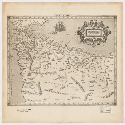
11. Africae I Tab Creator: Mercator, Gerhard, 1512-1594 (المنشئ) Date: Date Issued: 1619?] Language: Latin Geographic region: Place of Production: xx, No place, unknown, or undetermined, [S.lAfrica, North Extent: 1 map ; 31 x 45 cm.
12. Akhbār al-uwal fī-man taṣarrafa fī Miṣr min arbāb al-duwal Creator: Isḥāqī, Muḥammad ibn ʻAbd al-Muʻṭī, -1649 or 1650 (المنشئ) Date: Date Created: 1733 Language: Arabic Geographic region: Place of Production: xx, No place, unknown, or undeterminedEgypt Time period: 640-1882 Extent: 1 v. (325 leaves) ; 21 cm.