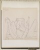
Genre/Subject MatterThese two small watercolour drawings depict scenes taken from life at the Settlement of Aden in 1871. Both drawings focus on Arabs’ use of camels as a form of transport.In the left-hand drawing, four veiled women perch alongside one another atop a litter held in place on the back of a light-haired camel. All four women are obscured in blue robes; the woman on the right has an uncovered face, while only the eyes of the other three women are visible.A tall, slender man wearing only a blue loincloth and turban leads the camel by a tether attached to a harness about its muzzle. He holds what appears to be a walking stick or cane in his right hand.The right-hand image shows an Arab man standing balanced on the neck of a dark-haired camel. He is wearing a turban and loincloth, which is held together by a belt that also holds a
janbiyain place. Both the material of the turban and loincloth are blue with red detailing and have been rendered very delicately in order to illustrate this. The man wears an object at his side, held there by a strap that crosses his torso. He whirls a whip above his head. Behind him, balanced on the camel’s saddle is a long-barrelled rifle; it has been decorated in black and white concentric stripes.Both drawings are stylistically in keeping with other sketches of ‘natives’ in this volume and in the related files Mss Eur F140/232 and Mss Eur F140/233, which, together with this volume, complete the trio of journals created by Jeffrey C. Amherst.InscriptionsLower left corner: ‘Aden – Oct 22nd /71’Temporal ContextThe drawing was made during the period Amherst was based at Aden, between 30 November 1870 and 1871/1872. It is likely to have been sketched from life either at or near the Isthmus Position, where two companies of British and two companies of Native Infantry were regularly based, according to an 1877 publication (F. M. Hunter,
An Account of the British Settlement at Aden, (London: Trübner & Co., 1877)) and where Amherst was attending a musketry course between 18–28 October 1871. Amherst moved about frequently between Crater, Isthmus, Ras Marshag and elsewhere during his time at Aden.2 drawings; watercolour and pencil on paper, pasted into volumeDimensions:108 x 180 mm [landscape]Materials:Pencil on paperCondition:The paper is slightly foxed, with light surface residue but otherwise in good condition with adhesive still sturdy.Foliation:The images have been assigned a sequential number, 5, which is written in pencil in the lower right corner of the page onto which the image is pasted.
The recto of folio 75 and the verso of folio 76 contain rough geographical pencil sketches. The first shows a particular area of Nejd [Najd] in relation to key villages and towns; the second appears to show a valley, or other similar geographic feature, with place names and travelling directions also given.The recto of folio 76 contains a brief list of five placenames in Nejd, given in both English and Arabic.The sketches are undated, however the information contained within them would have been compiled by Lewis Pelly during his trip to Riyadh in February to March 18652 folios
Genre/Subject Matter:These four topographical views of the coastline along the Red Sea coast are sketched from on board ship.The upper image shows either the city of Jeddah or the town of Hodedda [Al Hodeida] with the Hijaz mountain range visible in the background. Right of centre, one peak is identified as ‘Sugar Loaf’ or ‘Gebel Yemmenere’: this may refer to Jabal Jimām, a mountain due east across the coastal plain from Hodedda.At far left several windmills are indicated; to their right a structure with high walls and a domed roof, which may indicate a mosque or mausoleum. Further mosques are indicated at right along with a fortified structure at far right.The middle image is a hastily sketched out series of mountains; inscriptions indicate locations that cannot be verified such as ‘Sennam’ and ‘Gebel ‘Ulmayer’.The lower image may be a continuation of the upper topographical view. Fortifications lead from far left towards the centre, while the highest peaks in the range of mountains in the background are identified as ‘Saddle Hill’ or ‘Gebel Addar’.On the verso a further hastily sketched out topographical view shows some low-lying tents or other structures along a coastline, with mountains in the background.Inscriptions:Recto:Above upper image, in pencil: ‘Sugar Loaf or Gebel Yemmenere.’Below upper image, in pencil: ‘[lost]ddah’Above middle image at left, in pencil: ‘Semman’; ‘end of [illegible] Bay [illegible]’; ‘Gebel Ullmeyer.’Above lower image, at left, in pencil: ‘Saddle hill’; ‘Gebble Addar’Verso:Upper left corner, in pencil: ‘WD3534’Above image, in pencil: ’Towards the end of Judda [sp?] Bay to the North &’; ‘Northern part of the range left of the Town Domarrar[sp?]’4 topographical views on 1 sheet of paperDimensions:305 x 425 mmMaterials:Pencil on paperCondition:Surface dirt coats the recto and verso. Staining spreads from the lower left to the upper left. The paper is torn extensively at all edges, and along former folds, with the entire lower right square missing. However, repair work has stabilised the sheet.
Genre/Subject Matter:These two topographical views of the coastline along the Red Sea coast are sketched from on board ship.On the recto is a detailed view of the town of Suakin, Sudan. Two large towers, at centre and at right may be minarets, while at far left the stern of a British ship bears a flag featuring a Union Jack in the upper left corner.On the verso a more distant topographical view of a coastline along the Red Sea coast bears the partially intact inscription ‘[…] from the South to the North’. At right, a high peak is indicated with an asterisk. Although some further inscriptions in the area of the beach appear to name the peak, these are illegible.Inscriptions:Recto:Upper right corner, in pencil: ‘Suakin’Verso:Upper left corner, in pencil: ‘WD3529’; ‘[…] from the South to the North’Beach area, in pencil: ‘[illegible] Peak’2 partial pencil drawings on paperDimensions:82 x 210 mmMaterials:Pencil on paperCondition:Heavy surface dirt coats the recto and verso. The paper is torn at the right edge, however, repair work has stabilised the sheet.
Genre/Subject Matter:These two topographical views of the coastline along the Red Sea coast are sketched from on board ship.The upper image shows the town of Hodedda [Al Hodeida] from a distance of two miles. Although the sketch is incomplete, a number of details are visible: at right a large fortified structure stands alongside a minaret-like tower. Immediately left of centre another smaller fortified structure is visible set back off the shoreline, where several boats are indicated. At far left a further fortified structure is indicated.The lower image shows a large fort from a nearer vantage point.Inscriptions:Recto:Above upper image, in pencil: ‘Town of Hoddeda distant 2 miles – High […]’Above upper image at left, in pencil: North East N35E.Above lower image at right, in pencil: ‘Fort and […]’Verso:Lower left corner, in pencil: ‘WD3533’2 topographical views on 1 sheet of paperDimensions:305 x 205 mmMaterials:Pencil on paperCondition:Surface dirt coats the recto and verso. The paper is torn extensively at the right edge, as well as less severally at all other edges. However, repair work has stabilised the sheet.
Genre/Subject Matter:These two topographical views of the coastline along the Red Sea coast are sketched from on board ship.On the recto is a relatively detailed view of a marshy coastline, with mountains in the background. Several boats at sail and a stand of trees are the central features of the view.Beneath the image an inscription compares the location shown in this view with another; neither location can be determined with accuracy.On the verso a very narrow and incomplete topographical view of mountainous land appears above a partial inscription.Inscriptions:Recto:Upper left, in pencil: [illegible]Below drawing, in pencil: ‘The appearance of the land at Shaik Barood [?] is nearly the same as at Gheekye [?]’Verso:Lower left corner, in pencil: ‘WD3530’Lower right, in pencil: ‘Appearance of the land […]’2 partial pencil drawings on paperDimensions:73 x 213 mmMaterials:Pencil on paperCondition:Heavy surface dirt coats the recto and verso. The paper is torn at all edges, however, repair work has stabilised the sheet.
Genre/Subject Matter:These two topographical views of the Red Sea coast are sketched from on board ship.On the recto is a detailed view of a stretch of coastline with mountains in the background. Immediately right of centre a large number of palm trees have been represented. At far left is a Martello tower while left of centre is a shape that may denote a boat at anchor or pulled up on shore. At centre a domed building may indicate a mosque or mausoleum.On the verso a less detailed and rather hurried sketch of a town takes up a portion of the right-hand side of the sheet.Inscriptions:Verso:Upper left corner, in pencil: ‘WD3532’Above image, at right: ‘[…] covered with clouds’2 partial pencil drawings on paperDimensions:120 x 428 mmMaterials:Pencil on paperCondition:Heavy surface dirt coats the recto and verso. The paper is torn at all edges and especially along the central fold, however, repair work has stabilised the sheet.
Genre/Subject Matter:These two topographical views of the Red Sea coast are sketched from on board ship.On the recto is a detailed view of a large, fortified town, with mountains in the background. A long high wall separates the town from the sea, with various towers located along its length. At least one of these is a martello tower. Two towers, perhaps minarets, are visible left of centre and at right. There are no inscriptions indicating the location of the town.On the verso a less detailed and rather hurried sketch of the town of ‘El Cassar’ [?] takes up the right-hand side of the sheet.Inscriptions:Verso:Upper left corner, in pencil: ‘Town of El Caſsar/Cassar[?]’2 partial pencil drawings on paperDimensions:115 x 420 mmMaterials:Pencil on paperCondition:Heavy surface dirt coats the recto and verso. The paper is torn at all edges and especially along the central fold, however, repair work has stabilised the sheet.
Genre/Subject Matter:These two sequential topographical views of Babelmandel Cape [Ras Bab-el-Mandeb], sketched from on board ship.The area shown is a fully worked view based on the sketches found in WD3528 and show the following features of the coastline, from left to right: Fisher’s or Pilot’s Island [Fisherman’s Rock or Pilot’s Rock / Shaykh Malu Island]; Babelmandel Cape [Ras Bab el Mandeb]; Babelmandel Quoin [a wedge-shaped point on Ras Bab el Mandeb]; Coast of Babelmandel [Ras Bab-el-Mandeb].Inscriptions:Recto:From left to right, below image, in pen: ‘Fisher’s or Pilot’s Island’; ‘Babelmandel Cape’; ‘Babelmandel Quoin’; ‘Coast of Babelmandel’.Far right and lower left, in pen: ‘a’2 sequential, topographical, watercolour views on 1 sheet of paperDimensions:148 x 530 mmMaterials:Watercolour and pen on paperCondition:Surface dirt coats the recto and verso, particularly at left edge where staining is also visible.. The paper is extensively cracked along right-hand fold and left-hand edge, however, repair work has stabilised the sheet.
Genre/Subject Matter:View of several colonial buildings at the foot of mountains, probably at Aden. This unfinished pencil sketch may depict Haines’ first residence in Crater.A cross or flagstaff on the lowest peak at upper centre may provide additional clues as to its location.Inscriptions:Verso, in pencil, upper left: ‘WD3483’Temporal Context:This sketch was probably made between January 1939, when Stafford Bettesworth Haines seized Aden, and 1854, when he was recalled to Bombay to face embezzlement and fraud charges, during which time Haines administered Aden.1 pencil drawing on paperDimensions:302 x 453 mmMaterials:Pencil on paperCondition:Heavy surface dirt coats the recto and verso, especially at edges. The paper is heavily cracked and torn at all edges, but has been stabilised by conservators.
Drawing of one of the possible landing grounds at Sukra (also Sauqirah) Bay as it has been described by Air Officer Commanding and the Political Agent, Muscat.1 drawingMaterials: contact print with manuscript addition in pencil.Dimensions: 240 x 150mm, on sheet 260 x 180mm.
Drawing of one of the possible landing grounds at Sukra (also Sauqirah) Bay as it has been described by Air Officer Commanding and the Political Agent, Muscat.1 drawingMaterials: contact print with manuscript addition in pencil.Dimensions: 247 x 160mm, on sheet 265 x 185mm.