Map of the Persian Gulf and surrounding area, ranging from Ahwaz [Ahvaz, Iran] in the top left-hand corner to Maskat [Muscat, Oman] in the bottom right-hand corner. The map depicts states, provinces, towns, islands, and landmarks, and provides indication of hydrology and relief. The map includes a note on depths (of the Gulf) indicated on the map, which is printed in the bottom left-hand corner.Included on the map is a smaller map in the top right-hand corner, entitled 'Mond van de Shatt El `Arab', which shows the Shatt El Arab [Shatt al Arab] and surrounding area.Published by the journal of the Royal Dutch Geographical Society (
Tijdschrift van het Koninklijk Nederlandsch Aardrijkskundig Genootschap), 1907.1 mapMaterials: Printed in colour on paperDimensions: 404 x 500mm, on sheet 461 x 695mm
Facsimile of a 1646 map of the Persian Gulf from the ship journal of Captain Cornelis Roobacker. Published by the journal of the Royal Dutch Geographical Society (
Tijdschrift van het Koninklijk Nederlandsch Aardrijkskundig Genootschap), 1907.1 mapMaterials: Printed in colour on paperDimensions: 519 x 708mm, on sheet 609 x 914mm
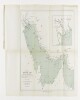
Series of four tracings related to the Persian Gulf and Gulf of Oman copied by Frederick Charles Danvers in the late 19th century. The original charts, produced in the second half of the 17th century by an anonymous Dutch chart maker, are housed in the State Archive (Nationaal Archief), The Hague, in 'VOC – Atlas van Isaac de Graaf'.4 manuscript charts
Distinctive Features:Depths shown by soundings with shoals and rocks represented by dots and crosses. Some settlements shown pictorially.Contains three charts showing: the coast from the Musandam Peninsula to Muscat, at the left portion of sheet; ‘De Bay van Mascatta’ in the top right; and Strait of Hormuz in the bottom right. Copied from original chart produced during an expedition along the Oman coast in 1666.3 maps on 1 sheetMaterials:Pen and ink with wash on tracing paperDimensions:523 x 349 mm or smaller, on sheet 525 x 738 mm
Distinctive Features:Depths in the Strait of Hormuz and along the coasts of Persia and Oman shown by soundings. Shoals and rocks represented by dots and crosses with annotations.Top and left margins are divided and marked with numbers.1 mapMaterials:Pen and ink with wash on tracing paperDimensions:517 x 739 mm
Distinctive Features:Depths along the coasts of Persia and Oman shown by soundings. Shoals and rocks indicated by dots and crosses with annotations. Settlements with Dutch East India Company’s trading posts represented pictorially.1 mapMaterials:Pen and ink with wash on tracing paperDimensions:550 x 740 mm
Distinctive Features:Depths along the coasts of Persia and Oman shown by soundings with shoals and rocks represented by dots and crosses.Left and bottom margins are divided and marked with numbers.1 mapMaterials:Pen and ink with wash on tracing paperDimensions:533 x 739 mm