1. 'Das Reitkameel (Hèdjīn) des Scherīf Jaẖja, eines Sohnes des Scherīf Aẖmed, dessen Vater der berühmte 1886 verstorbene Grossscherīf Abd èl-Muṯṯálib (vergl. über diesen letzten König Mekka’s vom alten Schlage Mekka, Bd. I, S. 16ff., 174ff.), mit einer reich mit Silber gestickten Satteldecke (batāt). Den Zaum hält der Sklave Jaẖja’s; neben diesem steht Jaẖja selbst im Reiteranzug und links in langen Kleidern zwei Scherife niedrigen Ranges'. Photographer: al-Sayyid ʻAbd al-Ghaffār Date: 1886/1889 Language: Arabic Extent: 1 collotype print
2. 'Oestlicher Theil des Thales Muna'. Photographer: al-Sayyid ʻAbd al-Ghaffār Date: 1886/1889 Language: Arabic Extent: 1 collotype print
3. 'Westlicher Theil des sich von Westen nach Osten erstreckenden Thales Muna (Mina) während der grossen jährlichen Pilgerversammlung'. Photographer: al-Sayyid ʻAbd al-Ghaffār Date: 1886/1889 Language: Arabic Extent: 1 collotype print
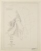
4. 'Pocket No. 25: Enclosure to Part III of Volume I of the Persian Gulf Gazetteer: Chart showing the Pearl Banks along the Arabian Shore of the Persian Gulf between Ras Tanura and Debai' Date: 1915/1915 Language: EnglishArabic Extent: 1 map
7. 'Erste Ansicht der Stadt Mekka: links im Hintergrund die Festung Djijād. Das grosse Gebäude rechts ist ied [sic for ‘die’] H̱amīdijjah, links daneben die Druckerei'. Photographer: al-Sayyid ʻAbd al-Ghaffār Date: 1886/1889 Language: Arabic Extent: 1 collotype print
8. 'Dritte Ansicht desselben; im Hintergrund windet sich der Weg nach Mekka'. Photographer: al-Sayyid ʻAbd al-Ghaffār Date: 1886/1889 Language: Arabic Extent: 1 collotype print
9. 'Dritte Ansicht der Stadt Mekka: links die nördliche Ecke der Moschee; ein wenig südostlich von derselben das Bāb ès-salām, durch welches die Pilger in die Moschee eintreten'. Photographer: al-Sayyid ʻAbd al-Ghaffār Date: 1886/1889 Language: Arabic Extent: 1 collotype print
10. 'Zweite Ansicht des Lagers der Mèjmūnahpilger'. Photographer: al-Sayyid ʻAbd al-Ghaffār Date: 1886/1889 Language: Arabic Extent: 1 collotype print
11. 'Zweite Ansicht der Stadt Mekka über die nordwestliche (rechts) und die südwestliche Seite (links) der Moschee hinaus'. Photographer: al-Sayyid ʻAbd al-Ghaffār Date: 1886/1889 Language: Arabic Extent: 1 collotype print
12. 'Die (vor wenigen Jahren errichtete) Druckerei in Mekka'. Photographer: al-Sayyid ʻAbd al-Ghaffār Date: 1886/1889 Language: Arabic Extent: 1 collotype print
13. 'ANNEXE B. SOUTH ARABIA ANGLO-TURKISH BOUNDARY.' Date: 1914/1914 Language: EnglishArabic Geographic region: YemenAden Protectorate Extent: 1 map on 4 sheets
14. 'ANNEXE B. SOUTH ARABIA ANGLO-TURKISH BOUNDARY. SHEET NO. 1' Date: 1914/1914 Language: EnglishArabic Geographic region: YemenAden Protectorate Extent: 1 map on 4 sheets
15. 'ANNEXE B. SOUTH ARABIA ANGLO-TURKISH BOUNDARY. SHEET NO. 2' Date: 1914/1914 Language: EnglishArabic Geographic region: YemenAden Protectorate Extent: 1 map on 4 sheets
16. 'ANNEXE B. SOUTH ARABIA ANGLO-TURKISH BOUNDARY. SHEET NO. 3' Date: 1914/1914 Language: EnglishArabic Geographic region: YemenAden Protectorate Extent: 1 map on 4 sheets
17. 'Westliche Seite des Berges'. Photographer: al-Sayyid ʻAbd al-Ghaffār Date: 1886/1889 Language: Arabic Extent: 1 collotype print
18. 'Der Berg ‘Arafah während der jährlichen Pilgerversammlung (von Süden aus gesehen)'. Photographer: al-Sayyid ʻAbd al-Ghaffār Date: 1886/1889 Language: Arabic Extent: 1 collotype print
19. 'South Arabia, Anglo-Turkish Boundary: Sheet No. 1' Date: 1905/1905 Language: EnglishArabic Extent: 1 folio
20. 'South Arabia, Anglo-Turkish Boundary: Sheet No. 2' Date: 1905/1905 Language: EnglishArabic Extent: 1 folio
21. 'South Arabia, Anglo-Turkish Boundary: Sheet No. 3' Date: 1905/1905 Language: EnglishArabic Extent: 1 folio
22. 'South Arabia, Anglo-Turkish Boundary: Sheet No. 4' Date: 1905/1905 Language: EnglishArabic Extent: 1 folio
25. ‘Chart of the Gulf of Persia. Constructed from the Trigonometrical Surveys Made by Order of The Hon.ble the Court of Directors of the United English East India Company; by George Barnes Brucks, Commander H.C. Marine. 1830. Engraved by R. Bateman, 85 Long Acre’ Contributor: James Horsburgh (publisher)Richard Bateman (artist)George Edward Brucks (surveyor) Date: 1832/1832 Language: EnglishArabic Geographic region: Persian Gulf Extent: 1 map on 2 sheets
26. ‘Arabic Characters to Accompany and for Insertion in the Chart of the Persian Gulf’ Date: 1825/1825 Language: EnglishArabic Extent: 1 item
27. 'Das Grab der Mèjmūnah und die nächste Umgebung'. Photographer: al-Sayyid ʻAbd al-Ghaffār Date: 1886/1889 Language: Arabic Extent: 1 collotype print
28. 'Das Grab der Sittanā Mèjmūnah und Lager dorthin gepilgerter Mekkaner (vergl. für die Beschreibung des Festes der Sittanā Mèjmūnah Mekka, Bd. II, S. 52ff.)'. Photographer: al-Sayyid ʻAbd al-Ghaffār Date: 1888/1888 Language: Arabic Extent: 1 collotype print
29. 'Zwei verschiedene Aufnahmen der Rīkah, des Thronsessels, auf welchen man in Mekka die jungfräuliche Braut in der Duchlah-nacht zu erheben pflegt (vergl. Mekka, Bd. II, S. 167ff.). Auf B sitzt der Bräutigam dort, wo die Braut sitzen soll.' [1/2] Photographer: al-Sayyid ʻAbd al-Ghaffār Date: 1886/1889 Language: Arabic Extent: 1 collotype print
30. 'Zwei verschiedene Aufnahmen der Rīkah, des Thronsessels, auf welchen man in Mekka die jungfräuliche Braut in der Duchlah-nacht zu erheben pflegt (vergl. Mekka, Bd. II, S. 167ff.). Auf B sitzt der Bräutigam dort, wo die Braut sitzen soll.' [2/2] Photographer: al-Sayyid ʻAbd al-Ghaffār Date: 1886/1889 Language: Arabic Extent: 1 Collotype print
31. 'Pilgerlager in der Ebene östlich vom ‘Arafah-berge'. Photographer: al-Sayyid ʻAbd al-Ghaffār Date: 1886/1889 Language: Arabic Extent: 1 collotype print
32. 'Ansicht der Moschee, während darin ein gemeinschaftliches Çalāt abgehalten wird (vergl. hierzu Mekka, Bd. II, S. 88)'. Photographer: al-Sayyid ʻAbd al-Ghaffār Date: 1888/1888 Language: Arabic Extent: 1 collotype print
33. 'Die zwischen Muna und ‘Arafah gelegene Pilgerstation Muzdal’fah'. Photographer: al-Sayyid ʻAbd al-Ghaffār Date: 1886/1889 Language: Arabic Extent: 1 collotype print
34. 'Vierte Ansicht der Stadt Mekka'. Photographer: al-Sayyid ʻAbd al-Ghaffār Date: 1886/1889 Language: Arabic Extent: 1 collotype print
35. 'SKETCH MAP OF QATAR PENINSULA' Contributor: Bahrain Political Agency (creator) Date: 1934/1936 Language: EnglishArabic Geographic region: Kuwait Extent: 1 map sheet
36. 'SKETCH MAP OF QATAR PENINSULA' Contributor: Bahrain Political Agency (creator) Date: 1934/1936 Language: EnglishArabic Geographic region: Kuwait Extent: 1 map sheet
37. Title deed plan of land at Umm al Hasam, Manamah Contributor: James Orton (correspondent)Francis Warden (correspondent) Date: 1944/1944 Language: Arabic Geographic region: JufairJazīreh-ye HengāmManamaBūshehrAbū-ShahrHormuz Isle Extent: 1 plan
38. Title deed plan of land at Ghosaibia, Manamah Contributor: James Orton (correspondent)Francis Warden (correspondent) Date: 1944/1944 Language: Arabic Geographic region: JufairJazīreh-ye HengāmManamaBūshehrAbū-ShahrHormuz Isle Extent: 1 plan
39. Sketch Map of Gwadur and Surrounding Region Date: 1941/1951 Language: EnglishArabic Extent: 1 map
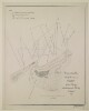
40. Sketch map of Pearl Banks between Koweit and Ras Tanura Date: 1906/1906 Language: EnglishArabic Extent: 1 map
41. ‘Trigonometrical Plan of the Back-water at Amulgawein by Lieut.t G.B. Brucks under the direction of Lieut.t J.M. Guy, H.C.Marine. 1822’ Contributor: John M. Guy (surveyor)George Edward Brucks (surveyor)Michael Houghton (artist) Date: 1822/1822 Language: EnglishArabic Geographic region: Amulgawein Extent: 1 map
42. ‘Trigonometrical Plan of the Back-water of Debai by Lieut.t R. Cogan under the direction of Lt. J.M. Guy, H.C.Marine. 1822. Drawn by M. Houghton’ Contributor: Robert Cogan (surveyor)John M. Guy (surveyor)Michael Houghton (artist) Date: 1822/1822 Language: EnglishArabic Geographic region: Debai Extent: 1 map
43. ‘Trigonometrical Plan of the Back-water at Sharja by Lieut.t R. Cogan under the direction of Lt. J.M. Guy, H.C.Marine. 1822’ Contributor: Robert Cogan (surveyor)Michael Houghton (artist)John M. Guy (surveyor) Date: 1822/1822 Language: EnglishArabic Geographic region: Sharjah Extent: 1 map
44. ‘Trigonometrical Plan of the Entrance of the Back-water at Aymaun by Lieut.t R. Cogan under the direction of Lt. J.M. Guy, H.C. Marine. 1822. Drawn by M. Houghton’ Contributor: Robert Cogan (surveyor)John M. Guy (surveyor)Michael Houghton (artist) Date: 1822/1822 Language: EnglishArabic Geographic region: Aymaun Extent: 1 map
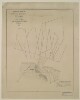
45. A map of pearl banks in Persian Gulf Date: 1940/1940 Language: Arabic Geographic region: Persian Gulf Extent: 1 map
46. Copy of Arabic plan showing site acquired by the British Government for Naval Base Juffair, Manama Date: 1929/1939 Language: Arabic Extent: 1 map
47. Copy of Arabic plan showing site acquired by the British Government for Naval Base Juffair, Manama Date: 1929/1939 Language: Arabic Extent: 1 map
48. Copy of Arabic plan showing site acquired by the British Government for Naval Base Juffair, Manama Date: 1929/1939 Language: Arabic Extent: 1 map