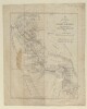
1. ‘Persia compiled principally from original authorities by Captain (Local Major) O.B.C.ST. John, (Royal Engineers) by order of H.M. Secretary of State for India’ Contributor: Edward Stanford and Co, publishers and stationers (surveyor)Oliver Beauchamp Coventry St John (surveyor) Date: 1876/1876 Language: English Geographic region: Persia Extent: 1 map on 12 sheets
2. 'Map of Persia' Date: 1912/1912 Language: English Geographic region: PersiaPersian Gulf Extent: 1 map
3. 'MAP SHOWING PROPOSED BAGHDAD RAILWAY' Date: 1903/1903 Language: English Geographic region: RussiaPersiaArabiaOttoman EmpireBaghdad Extent: 1 map
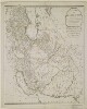
4. 'A New Map of the Empire of Persia from Monsr. D'Anville, First Geographer to the most Christian King, with Several Additions and Emendations' Contributor: Laurie & Whittle, Publishers and publishing (publisher)Jean Baptiste Bourgignon d'Anville (publisher) Date: 1794/1794 Language: English Geographic region: Persia Extent: 1 map sheet
5. 'Geographic Map NORTH EASTERN SAUDI ARABIA' Contributor: Survey Section, General Staff (publisher) Date: 1940/1940 Language: English Geographic region: Arabian PeninsulaPersia Extent: 1 map on 4 sheets
6. ‘Map of parts of Arabia and Persia in two sheets’ Date: 1883/1883 Language: English Geographic region: PersiaArabia Extent: 1 map sheet
7. ‘Map of Persia showing limits of British Judicial and Consular Jurisdiction within Sphere of British Residency and Consulate General Bushire’ Date: 1912/1912 Language: English Geographic region: Persia Extent: 1 map
8. ‘MAP TO ILLUSTRATE THE TELEGRAPH LINES OF THE INDO-EUROPEAN TELEGRAPH DEPARTMENT AND CONNECTED SYSTEMS’ Date: 1930/1940 Language: English Geographic region: PersiaBaluchistanPersian Gulf Extent: 1 map
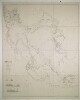
9. 'Map to illustrate Baron C.A. de. Bodes route from Kazerun to Shushter through the Countries of the Manasoni Khoghi & Bakhtyari Tribes in 1841' Date: 1841/1841 Language: English Geographic region: Persia Extent: 1 map
10. ‘Sketch Map of Kuwait and Neighbouring Country’ Date: 1928/1928 Language: English Geographic region: NajdKuwaitPersia Extent: 1 map
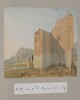
11. ‘Colonel D’arcy Drawings Made During the Embassy to Persia 1810–12’ by Joseph D’Arcy (1780–1846) Contributor: Joseph D'Arcy (artist) Date: 1810/1812 Language: English Geographic region: AzerbaijanPersiaTurkeyArmenia Extent: Album of 58 watercolour drawings of views of Persia, Azerbaijan, Armenia and Turkey, mostly made during the Ouseley embassy to Tehran (1810–12), 1 newspaper cutting, 2 notes and 2 handlists (c. 1880) lightly tipped into a leather-bound album.
12. Administrative map of Persian consulates Date: 1907/1907 Language: English Geographic region: Persia Extent: 1 map