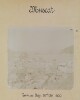
Genre/Subject Matter:View of the walls of a fort on Hormuz Island, perhaps the Fort of Our Lady of the Conception, also known as the Portuguese Castle, the construction of which was completed by the Portuguese after conquering the island in 1515.Two men stand in front of the crumbling walls, one immediately right of centre and one at far right, perhaps for the purpose of providing a scale.Inscriptions:Ink, below image: 'Exterior of Fort, Hormuz, showing mouldering walls.'1 b&w silver gelatin printDimensions:145 x 200 mmCondition:The print is in good condition, though the mounting paper is heavily foxed and crumblingFoliation:‘12’Process:Silver gelatin
Imprint:Published by James Horsburgh, Hydrographer to the East India Company.Distinctive Features:Relief shown by shading. Depth shown by soundings.Nautical chart of the northern shores of the Persian Gulf showing the coastline east of Shatt al-Arab to Bushire [Bushehr] compiled from the surveys carried out by the Bombay Marine’s officers between 1820 and 1829.Shows sandbanks and rock hazards; location of ruins and old entrance of Indian River marked.1 mapDimensions:504 x 599 mm, on sheet 565 x 777 mm
Imprint:General Staff India.Distinctive Features:Sketch map issued as an ‘Appendix B (1) Serial No. 12 D
2’ to illustrate British military operations on the Euphrates River from 26 June to 25
July 1915. Shows swamps and inundated fields with position for safe landing
marked.Marked ‘For Official Use Only’.In the left-hand corner: ‘S.D.O. No. 1356, September,
1915’.1 mapDimensions:200 x 330
mm
Oblique photograph taken in the course of an aerial reconnaissance of the Qatar Peninsula on 11 October 1935 by Squadron Leader J H Dand, Air Headquarters, British Forces in Iraq, Hinaidi. There is a report on the reconnaissance at IOR/R/15/2/159, folios 18-20.Inscribed: 800 feet.1 black and white photographDimensions: 180 x 180 mm.Foliation: the folio number, 28, is written in pencil, enclosed in a circle, and appears below the photograph near the right edge of the recto side of the folio. A previous foliation number has been crossed out.
Oblique photograph taken in the course of an aerial reconnaissance of the Qatar Peninsula on 11 October 1935 by Squadron Leader J H Dand, Air Headquarters, British Forces in Iraq, Hinaidi. There is a report on the reconnaissance at IOR/R/15/2/159, folios 18-20.Inscribed: 800 feet.1 black and white photographDimensions: 180 x 180 mm.Foliation: the folio number, 27, is written in pencil, enclosed in a circle, and appears above the photograph near the right edge of the recto side of the folio. A previous foliation number has been crossed out.
Oblique photograph taken in the course of an aerial reconnaissance of the Qatar Peninsula on 11 October 1935 by Squadron Leader J H Dand, Air Headquarters, British Forces in Iraq, Hinaidi. There is a report on the reconnaissance at IOR/R/15/2/159, folios 18-20.Inscribed: 700 feet.1 black and white photographDimensions: 180 x 180 mm.Foliation: the folio number, 22, is written in pencil, enclosed in a circle, and appears below the photograph near the right edge of the recto side of the folio. A previous foliation number has been crossed out.
Oblique photograph taken in the course of an aerial reconnaissance of the Qatar Peninsula on 11 October 1935 by Squadron Leader J H Dand, Air Headquarters, British Forces in Iraq, Hinaidi. There is a report on the reconnaissance at IOR/R/15/2/159, folios 18-20.Inscribed: 800 feet.1 black and white photographDimensions: 180 x 180 mm.Foliation: the folio number, 26, is written in pencil, enclosed in a circle, and appears below the photograph near the right edge of the recto side of the folio. A previous foliation number has been crossed out.
Oblique photograph taken in the course of an aerial reconnaissance of the Qatar Peninsula on 11 October 1935 by Squadron Leader J H Dand, Air Headquarters, British Forces in Iraq, Hinaidi. There is a report on the reconnaissance at IOR/R/15/2/159, folios 18-20.Inscribed: 800 feet.1 black and white photographDimensions: 180 x 180 mm.Foliation: the folio number, 24, is written in pencil, enclosed in a circle, and appears below the photograph near the right edge of the recto side of the folio. A previous foliation number has been crossed out.Condition: the caption is faint and not entirely legible.
Oblique photograph taken in the course of an aerial reconnaissance of the Qatar Peninsula on 11 October 1935 by Squadron Leader J H Dand, Air Headquarters, British Forces in Iraq, Hinaidi. There is a report on the reconnaissance at IOR/R/15/2/159, folios 18-20.Inscribed: 800 feet.1 black and white photographDimensions: 180 x 180 mm.Foliation: the folio number, 23, is written in pencil, enclosed in a circle, and appears above the photograph near the right edge of the recto of the folio. A previous foliation number has been crossed out.
Oblique photograph taken in the course of an aerial reconnaissance of the Qatar Peninsula on 11 October 1935 by Squadron Leader J H Dand, Air Headquarters, British Forces in Iraq, Hinaidi. There is a report on the reconnaissance at IOR/R/15/2/159, folios 18-20.Inscribed: 800 feet.1 black and white photographDimensions: 180 x 180 mm.Foliation: the folio number, 25, is written in pencil, enclosed in a circle, and appears above the photograph near the right edge of the recto side of the folio. A previous foliation number has been crossed out.
Imprint:Berlin, published by Dietrich Reimer and engraved by Heinrich Mahlmann.Edition statement:Third edition; compiled and prepared by Dr. Heinrich Kiepert.5 maps
Map showing the area of Bahrain that the crude oil pipe line was proposed to traverse. The pipeline runs from the west coast of Bahrain between Kuraiya [Al Qurayyah] and Jasra [Al Jasrah] to the Bahrain Petroleum Company (BAPCO)'s refinery on the west coast near Nuwaidrat [An Nuwaydirāt].The pipeline is marked by two parallel ink lines and coloured red. Its direction is marked using longitute and latitude co-ordinates and distances in feet. Additional longitute and latitude markers are included near the village of Buri [Būrī] to show where the route had been revised.A legend includes a dotted line showing gardens, a dashed line showing roads and a longer dashed line showing the boundary of BAPCO's concession area.1 Map Sheet.Foliation: A pencil number enclosed in a circle is located in the top right hand corner of the recto of the folio.Materials: Parchment sheetDimensions: 440mm x 1010mm
Map showing the area of Bahrain that the crude oil pipe line was proposed to traverse. The pipeline runs from the west coast of Bahrain between Kuraiya [Al Qurayyah] and Jasra [Al Jasrah] to the Bahrain Petroleum Company (BAPCO)'s refinery on the west coast near Nuwaidrat [An Nuwaydirāt]. The pipeline is marked by two parallel ink lines and its direction is marked using longitute and latitude co-ordinates and distances in feet.A legend includes a dotted line showing gardens, a dashed line showing roads and a longer dashed line showing the boundary of BAPCO's concession area.1 Map Sheet.Foliation: A pencil number enclosed in a circle is located in the top right hand corner of the recto of the folio.Materials: Parchment sheetDimensions: 250mm x 1010mm
The map shows Mesopotamia and the Turco-Persian frontier with the main rivers and cities. A red line indicates the principal pilgrim route from Hamadan, Persia, to Nejef.1 mapMaterials: Printed on paper.Dimensions: 330 x 200mm.
The map shows the Shatt-ul-Arab [Shatt al-Arab] waterway with the frontier line between Turkey and Persia show in red ink.1 mapMaterials: Printed on paper.Dimensions: 330 x 200mm.
Distinctive Features:Relief shown by hachures and spot heights.Title continues: ‘Zu C. Ritter’s Erdkunde, Buch III, West-Asien, Theil XII. Bearbeitet von H. Kiepert, herausgegeben von C. Ritter. Berlin, 1852 Verlag von Dietrich Reimer’.Map of Hedjaz [Hejaz] province showing various routes including the Hajj pilgrimage, Carsten Niebuhr exploration journey, and J.G. Hulton and Charles J. Cruttenden expedition of 1836.In the bottom right-hand corner there is a table of reference listing Arabic geographic terms with German equivalents and abbreviations.Includes two insets:• plan of Mecca entitled ‘Mekka nach Burckhardt’ drawn to scale 1:30,000 with districts numbered and listed in a table of reference; • map of peninsula and the port of Aden entitled ‘Halbinsel und Hafen von Aden’ drawn to scale 1:200,000 with depths shown by contours.1 mapDimensions:491 x 349 mm, on sheet 584 x 476 mm
Genre/Subject Matter:View of a steamship, ‘British Sailor’, moored alongside a quay at Mina [Mina Salman Port], Bahrain.Inscriptions:Below image, in pen: 'British Sailor at Mina'Below image, in pencil: ‘506’1 b&w silver gelatin printDimensions:54 x 78 mmCondition:The image is in good condition.Foliation:‘506’Process:Silver gelatin print
Genre/Subject Matter:View from the stern of a steamship, ‘British Sailor’, at sail.Inscriptions:Below image, in pen: 'British Sailor'Below image, in pencil: ‘507’1 b&w silver gelatin printDimensions:54 x 78 mmCondition:The image is in good condition.Foliation:‘507’Process:Silver gelatin print
Genre/Subject MatterThis view of Bushire (Bushehr), from an elevated position looking south, is taken from the roof of the offices of Gray, Paul and Co. (sister firm to Gray, MacKenzie and Company), a company that acted as shipping agent for British India steamers between India and Europe, via the Gulf ports.A number of buildings are seen in the photograph, though relative degradation of the image obscures much of the background and horizon area. A building under construction extends from the lower left of the image to the centre. Immediately behind this, the terrace of a flat-roofed building is fenced off. Next to the building under construction, and immediately below the centre of the image, bricks can be seen stacked high against the wall of an adjacent building.In the far right of the image, towards the horizon, a domed roof can clearly be seen amongst the flat-roofed buildings. Although the dome is windowless, a smaller dome with openings to allow light to filter through sits atop it. This is possibly a bath house.InscriptionsLower right, in pencil, alongside image: ‘83’Below image: ‘The Town looking South from Gray. Paul's Office. 23. Feb. 1902’1 photographic printDimensions:109 x 155 mm [landscape]Format:Materials:Condition:The image is considerably faded throughout, with surface losses along the upper edge.Foliation:'83'Process:
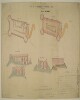
Distinctive Features:Space in the first line of title left blank.Includes ground plan and ‘PLAN OF TERRE PLEIN’ of Ras-Morbat Fort with corresponding longitudinal sections and elevations. Lettered for reference with a key in the bottom right-hand corner. Measurements reported.Inscriptions:On recto, bottom left-hand corner: ‘Isthmus Office July 15th 1846 Drawn by F. Welsh’.‘Copied in the Chief Engrs. Office Bombay 26th September 1846’.On recto, bottom center: ‘/Signed/ J. Kilner Captain Executive Engineer Aden’.On verso, bottom left-hand corner with bleed-through into the recto:‘In Bombay Secret Lre. No. 113 of 1846 Recd. via Southampton 10th Novr. 1846 Aden Fortifications’.1 sheetMaterials:Pen and ink with wash on tracing paperDimensions:695 x 1022 mm