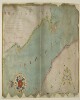
1. Chart of the Strait of Babellmandell made by John Friend Against ye East India hous in leaden hall Street London An.o Dn.o 1714 Date: 1714/1714 Language: English Geographic region: Babelmandel Extent: 1 map
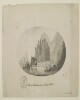
2. 'View of Muscat, entrance of Persian Gulph' Date: 1787/1787 Language: English Geographic region: Muscat Extent: 1 view
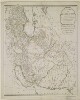
3. 'A New Map of the Empire of Persia from Monsr. D'Anville, First Geographer to the most Christian King, with Several Additions and Emendations' Contributor: Laurie & Whittle, Publishers and publishing (publisher)Jean Baptiste Bourgignon d'Anville (publisher) Date: 1794/1794 Language: English Geographic region: Persia Extent: 1 map sheet
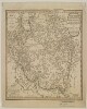
5. ‘Indiae Veteris Quatenus Macedonibus Nota Fuit Finitimarumque Regionum Specimen Geographicum’ Date: 1797/1797 Language: English Extent: 1 map sheet
7. Four nautical charts related to the Persian Gulf and Gulf of Oman Contributor: Frederic Charles Danvers (attributed name) Date: 1800/1899 Language: Dutch Extent: 4 manuscript charts
8. Charts of the Gulf of Oman and Strait of Hormuz Date: 1800/1899 Language: Dutch Geographic region: Gulf of Oman Extent: 3 maps on 1 sheet
9. Chart of the Gulf of Oman Date: 1800/1899 Language: Dutch Geographic region: Gulf of Oman Extent: 1 map
10. Nautical chart of the Persian Gulf Date: 1800/1899 Language: Dutch Geographic region: Persian Gulf Extent: 1 map
11. Chart of the Persian Gulf Date: 1800/1899 Language: Dutch Geographic region: Persian Gulf Extent: 1 map
12. East India or China Pilot, containing 126 charts chiefly published by James Horsburgh Contributor: James Horsburgh (publisher) Date: 1800/1899 Language: English Extent: 126 maps