Printed Confidential memorandum, headed 'Printed for the use of the Foreign Office', and signed by Alfred S Green, Foreign Office.The memorandum charts the history of the issue of the appointment of British officers to organise the Persian Army from the Treaty of Tilsit in 1807 to the year 1870, and cites relevant Foreign Office and India Office correspondence (with references recorded as marginal notes). The memorandum states that there had been no correspondence between the two departments since 1870. It concludes by stating that the British Government had recognised the expediency of granting the Shah of Persia's request (for the appointment of officers); that a difficulty arose from the question of whether the cost of paying the officers should be borne by the India Office, the Foreign Office, or the Shah's own Government; and that questions had arisen concerning the effect of such a measure on the political relations between Persia and Russia.1 file (6 folios)Foliation: the foliation for this description commences at f 118 and terminates at f 123, as it is part of a larger physical volume; these numbers are written in pencil, are circled, and are located in the top right corner of the recto side of each folio. An additional foliation sequence is also present in parallel between ff 5-137; these numbers are also written in pencil, but are not circled, and can be found in the same position as the main sequence.
Statement of witnesses taken by Col Phayre, Resident at Baroda, of all those individuals who had access to his private office room between 6am and 7am on 9 November 1874 and could have been involved in the attempt to poison him.The statements were prepared by Messrs Hearn, Cleveland, and Lee Warner, Solicitors to the Government of India in the matter of the Enquiry under Commission at Baroda.There are twenty-six statements, including Colonel Phayre's own account of the attempted poisoning from staff and individuals residing at the Residency, as well as further cross-examination of some of these witnesses, including several who were being held in custody over the incident.1 file (20 folios)Foliation: The file has been foliated in the front top right hand corner of each folio with a pencil number enclosed in a circle.
Telegraph and travel. A narrative of the formation and development of telegraphic communication between England and India, under the orders of Her Majesty's Government, with incidental notices of the countries traversed by the lines.Author: Colonel Sir Frederic John Goldsmid, CB, KCSI. Late Chief Commissioner Indo-European Telegraph; British Commissioner for settlement of the Perso-Baluch Frontier (1870-71) and Arbitrator in the Perso-Afghan boundary question (1872-73).Publication details: London. Macmillan and Co., 1874. R Clay, Sons and Taylor, printers, Bread Streat Hill.Physical Description: xiv, [2], 673, [3]p., [8] leaves of plates (2 folded): ii, maps, portrait; 23cm (8º).Ownership: With stamps of the India Office Library and embossed stamp of the "Secretary of State for India Library". Marginal ms. annotations in a contemporary hand in ink on pages 101, 194, 196, 264 and 527.1 volume (673 pages)This volume contains a table of contents giving chapter headings and page references, along with a list of illustrations giving titles and page references. There is also an index which begins on page 661.Dimensions: 232mm x 156mm
Memorandum written in French and published by the Foreign Office in 1874.The memorandum discusses the situation in Persia, including the interior and exterior threats the country faces, and the potential threat the situation poses to the borders of the British Empire.The perceived exterior threat to Perse is the progress and advancement of the Russian Empire in Asia and their perceived interest in occupying Merv, the ancient capital of Khorassan [Khorāsān]. The interior threat is considered to be the general situation in Persia and its difficulties in establishing administration within its own borders.Also discussed in the memorandum is the strength and skill of the Turcomanes (Turkmen) cavalry which could potentially disrupt Russia's plans in Asia and the lack of continuous British representation in Persia and the possible need to provide support to their ally in order to stop Russia from advancing through Asia.1 file (3 folios)Foliation: the foliation sequence commences at f 61, and terminates at f 63, as it is part of a larger physical volume; these numbers are written in pencil, and are located in the top right corner of the recto side of each folio.Pagination: the item also contains an original incomplete printed pagination sequence.
The file consists of a printed précis of correspondence taken from India Office records, issued by the India Office. The précis relates to the following two subjects:question of employing British officers in drilling, etc. the Shah's Army in Persia, consisting of extracts from printed works and other sources dated 1832-63, and extracts of correspondence with the Foreign Office, dated 1863-72 (folios 104-110);proposal to supply the Shah with ships to be commanded by British officers, largely consisting of extracts from correspondence with the Foreign Office, dated 1868-70 (folios 111-113).1 file (15 folios)Foliation: the foliation for this description commences at f 103 and terminates at f 117, as it is part of a larger physical volume; these numbers are written in pencil, are circled, and are located in the top right corner of the recto side of each folio. An additional foliation sequence is also present in parallel between ff 5-137; these numbers are also written in pencil, but are not circled, and can be found in the same position as the main sequence.
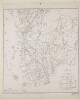
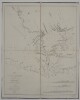
Map of Beluchistan [British Baluchistan] including Mekran [Makran] and the Perso-Beluch frontier. Annotations on the map indicate that it was drawn and compiled by Captain Beresford Lovett of the Royal Engineers, who was attached to the Persian-British Baluchistan Frontier Delimitation Commission, under Major General Frederic John Goldsmid. The map was produced from surveys by Major Edward Charles Ross, Assistant Political Agent at Gwadur [Gwadar], Lovett, and Quartermaster General Sargeant D Bower, Royal Engineers. The map was traced at the Presidency Drawing and Litho office at Bombay [Mumbai] in July 1874. The map indicates: hydrology; topography, with some indication of relief; settlements; the route of the Indo-European telegraph cable, shown as a solid red line.A printing statement in the bottom right corner of the map reads: ‘Helio. S.I.O., Calcutta.’1 mapDimensions:580 x 700 mm, on sheet 655 x 750 mm.Materials:printed on paper.
Report on the Administration of the Bushire Residency including that of the Muscat Political Agency, with Reports on Trade for 1873-74, printed at the Foreign Department Press, Calcutta, 1874.The report is split into two sections and further into subsections. The first section relates to the Residency at Bushire, the second to the Political Agency at Muscat.The first section on Bushire consists of three sub-sections:An administration report by the Political Resident in the Persian Gulf, Lieutenant-Colonel Edward Charles Ross, that gives an update on political and administrative matters for various places and sheikhdoms in the region, as well as notes on weather, medical matters, and the slave trade (folios 2-6);A trade report, also written by Ross, that includes notes on the various ports, the main commodities, transport, and customs (folios 6-9);Twenty-four tables of trade statistics (A-X) (folios 9-38).The second section on Muscat consists of two sub-sections:An administration report written by the Political Agent, Major Samuel Barrett Miles, which gives a political and administrative update on the country, including notes on slave traffic and trade (folios 38-40);Six tables of trade statistics (A-F) (folios 41-46).46 foliosThe report is arranged in two sections: the first relating to the Bushire Residency, the second the Political Agency at Muscat.
Imprint:Lithographed at the Topographical Depôt, Horse Guards, War Office. Major C. W. Wilson, R. E. director.Distinctive Features:Relief shown by shading.The map shows routes of various travellers from 1762 to 1873 with a list of explorers and dates of their journeys in the bottom right-hand corner below title. The location of tribes with their boundaries indicated by pecked or dotted lines.1 map sheetDimensions:533 x 855 mm, on sheet 609 x 889 mm
Distinctive Features:Relief shown by shading and spot heights. Boundary indicated by pecked line and tinted pink; unexplored areas labelled. Routes of various expeditions shown in colour with names of explorers and dates of their journeys given. Numerous notations on topographic features inserted on the map. Includes three longitudinal sections, a descriptive note on sources used in compilation of map and a key to colours.1 mapDimensions:914 x 1249 mm, on sheet 1008 x 1360 mm
Map compiled by Major Oliver Beauchamp Coventry St John of the Royal Engineers, by order of the Secretary of State for India, to show the western frontier of the territories of His Highness the Khán of Kálát, as determined by the Frontier Commission under Major General Sir Frederic John Goldsmid. The map indicates: hydrology; topography, with some indication of relief; settlements; the frontier, marked as a solid pink line; other proposed frontier lines: Sir Frederic Goldsmid’s line of 1871 (shown in green); Major Beresford Lovett’s frontier of 1871 (red); Major St John’s and Mr Blandford’s of 1872 (brown). Notes on the map’s sources and authorities are given under the map title.In the bottom right corner of the map are three sections: 1) between the Kharān desert and the Persian Gulf about the meridian of 63°; 2) between the Bampūr plain and the Persian Gulf about the meridian of 60°45’; 3) of the road between the Kharān desert and the Bampūr valley. The vertical scale of all three sections is 1 inch to 6,000 feet.Printing statements at the bottom of the map read ‘Trel. Saunders Lith. 1874.’ and ‘Heliozincographed at the Survey of India Offices, Calcutta [Kolkata].’1 mapDimensions:910 x 1255 mm, on sheet 948 x 1285 mm.Materials:printed on paper.
Official correspondence between Pelly and others concerning the preparation of an elementary Manual of Agriculture to be used in schools in Ajmer District.1 file, 4 items (11 folios)The correspondence within the file has been arranged chronologically by date.Foliation: The file has been foliated in the front top right hand corner of each folio with a pencil number enclosed in a circle.Binding: The contents of the file had been tied together with string which has been removed for conservation purposes and placed at the back of the file.