1. 'NORTH OF PAS PAR DALUN CARAVANSARAI LOOKING E.-N.-E.' Date: 1893/1983 Language: English Extent: 1 drawing
2. ‘Al Husen, stronghold of Shekh Awas Al Ahmadi in the Wadi Tiban.’ Date: 1905/1905 Language: English Extent: 1 illustration
3. ‘Plate I. Showing Officers Badges of Rank on Shoulder Straps (Field Service Order) with Colours of Branches of Service.’ Contributor: Simla Drawing Office, General Staff, India (publisher) Date: 1925/1925 Language: English Extent: 1 illustration
4. ‘Plate II. Plate showing Badges of Rank of Non-Commissioned Officers. Field Service Order.’ Contributor: Simla Drawing Office, General Staff, India (publisher) Date: 1925/1925 Language: English Extent: 1 illustration
5. ‘Eastern entrance to Mudariba Valley (looking N.) Showing the Alkami range of J. Am Ibdar.’ Date: 1905/1905 Language: English Extent: 1 illustration
6. ‘Musemir looking North from below camp of the Hants Regt. January and February 1904.’ Date: 1905/1905 Language: English Extent: 1 illustration
7. ‘Mafalis looking N. from the Nijd Rifad.’ Date: 1905/1905 Language: English Extent: 1 illustration
9. 'The North Pass of Aden or Baab el Yemen. Inside' by Stafford Bettesworth Haines Contributor: Stafford Bettesworth Haines (artist) Date: 1839/1854 Language: English Geographic region: Aden Extent: 1 pencil drawing on paper
11. ‘Panorama looking west over Turkish territory from the pass at the head of the Wadi Hilhal.’ Date: 1905/1905 Language: English Extent: 1 illustration
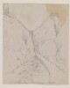
16. ‘Sketch to illustrate positions of Flagstaffs at Elphinstone Inlet [Khawr ash Shamm] and Sheep Island [Jazīrat Umm al Ghanam]’ Date: 1904/1904 Language: English Extent: 1 map
18. ‘Head of Haiki Valley (Ghail Samada) looking E. J. Hawab in background.’ Date: 1905/1905 Language: English Extent: 1 illustration
19. 'Rough Pencil Sketch from the Point Bungalo Ras Marbut, Aden' by Stafford Bettesworth Haines Contributor: Stafford Bettesworth Haines (artist) Date: 1839/1854 Language: English Geographic region: Ras Marbut Extent: 1 watercolour and pencil drawing on paper
20. 'ZANGU MAMELAY, LOOKING NORTH IN THE MARZ HAFTAWAN VALLEY' Date: 1893/1983 Language: English Extent: 1 drawing
22. ‘The Rock and Village of Balas (Jabal Jihaf) Looking East from Camp of Hants Regt.’ Date: 1905/1905 Language: English Extent: 1 illustration
24. ‘Entrance to the Gulf, and Musandim Island’ Date: 1906/1906 Language: English Geographic region: Strait of HormuzMussandim Extent: 1 map
25. ‘View to the south from near the top of Jabal Mafari.’ Date: 1905/1905 Language: English Extent: 1 illustration
27. ‘View east from J Abab at head of Wadi Kurim, opposite Al Husen’ Date: 1905/1905 Language: English Extent: 1 illustration
29. ‘Panorama showing ground traversed by Anglo-Turkish boundary ‘Haushabi-Humar’ to N. of ‘Ad Dareja’’ Date: 1905/1905 Language: English Extent: 1 illustration
30. ‘View up the Tiban N. from Lijma, showing Jabal Warwa.’ Date: 1905/1905 Language: English Extent: 1 illustration
32. ‘View from near ‘As Sueda’ in Uzlat of the Mafari, looking west.’ Date: 1905/1905 Language: English Extent: 1 illustration
33. ‘View from village of Lakmat Magharam (ruined) about 1½ miles west of Sanah [Ṣanʻā']’ Date: 1904/1904 Language: English Extent: 1 illustration
34. ‘Narrow strait of Bab-Al-Mandab and Shekh Said Hills taken from Obstruction Point Perim.’ Date: 1905/1905 Language: English Extent: 1 illustration
35. 'A Mussulman Temple, Aden' by Stafford Bettesworth Haines Contributor: Stafford Bettesworth Haines (artist) Date: 1839/1854 Language: English Geographic region: Aden Extent: 1 pencil drawing on paper
41. ‘Wadi Hidaba at well above Al ’Ashar (looking South up the Wadi). Juheli hills in background.’ Date: 1905/1905 Language: English Extent: 1 illustration
42. ‘The Wadi ’Ubil at Mijza (Shumaya) from high ground on the right bank.’ Date: 1905/1905 Language: English Extent: 1 illustration
43. ‘The Wadi Ma’din looking South from near Sanawi on right bank.’ Date: 1905/1905 Language: English Extent: 1 illustration
44. ‘The Wadi Ma’din looking E. from near Sanawi.’ Date: 1905/1905 Language: English Extent: 1 illustration
45. ‘Gorge and stream in Wadi Ziyak. (near Haushabi, N.W. border).’ Date: 1905/1905 Language: English Extent: 1 illustration
46. A rough sketch of the sections of Shaikh Ahmad's estate in Fao Date: 1938/1938 Language: English Extent: 1 map
47. Sketch of village of Mazub Habil Al Khadar looking North into Turkish [Ottoman] Territory Date: 1904/1904 Language: English Extent: 1 folio
49. Hand-drawn sketch of the villages of Shakhab, Kalaba, Mazoob Habil al Khada and Dthala Date: 1904/1904 Language: English Extent: 1 folio
50. Tracing of ‘Rough Sketch of proposed buildings at Angaum [Jazīreh-ye Hengām]’ Date: 1905/1905 Language: English Extent: 1 drawing
51. Draft pencil sketches of Nejd [Najd] territory Contributor: Sir Knight Lewis Pelly (creator)William Henry Colvill (creator)Sir Henry Bartle Edward Frere (creator)Sir Knight Frederic John Goldsmid (creator)Sir Knight William Henry Rodes Green (creator)Sir Knight Robert Phayre (creator)1st Earl of Northbrook Thomas George Baring (creator)Sir Knight William Lockyer Merewether (creator)William Gifford Palgrave (creator)Sir Knight Charles Umpherston Aitchison (creator) Date: 1865/1866 Language: EnglishArabic Geographic region: Shatt al ʻArabKoweitBaroda StateIranPersian GulfRajputanaRiyadhRussiaSindMuscatZanzibarAl-Hasa Extent: 2 folios
52. Houses at the foot of mountains, probably Aden Contributor: Stafford Bettesworth Haines (artist) Date: 1839/1854 Language: English Geographic region: Aden Extent: 1 pencil drawing on paper