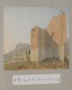
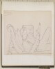
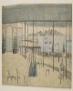
Genre/Subject Matter:This landscape view of a scene near Bushire [Būshehr] shows a trail winding from left through undulating landscape towards a flat plain below. In the background craggy peaks extend from right. Two figures on donkey or horseback can be seen at right while four further figures make their way along the path at left. It is not clear what mirage is being referred to in the title of the drawing.Temporal Context:Although the image dates from the Ouseley embassy 1810–12, the adjacent caption/description likely dates from c. 1880 and was written by later owner of the album, F. G. McCutcheon.Inscriptions:Recto:Lower right corner, in pencil: ‘28’Verso:Upper left, in pencil: ‘Abou-Shehr or Bushire, Persian Gulf’Lower left corner, in pencil: ‘J. D’Arcy. Malvern’Along lower edge, in pencil: ‘On the road to Dalkin [Daliki] from Bushire showing the mirage’Lower right corner, in pencil: ‘Novr. 2 1852’; ‘28’Adjacent inscription: ‘28.On the road from Bushire (Persian Gulf) to Dalkee showing the mirage’1 watercolour drawing on paperDimensions:108 x 282 mmMaterials:Watercolour on paperCondition:Light surface dirt coats the recto and verso, with staining along all edges. Two small puncture holes at upper left and right corners indicate that the drawing was at one time pinned up. A small tear or cut can be seen extending diagonally from lower edge , left of centre, for 10 mm.
Genre & Subject MatterAs well as four photographs, stamps, seals, printed documents, handwritten texts, maps and letters, this album contains fifty-one pencil, watercolour or pen and ink drawings; eight created while Augustus Fortunatis Bellasis was Collector and Magistrate at Hyderabad (Sind) in 1855 and the rest while he was on furlough travelling through the Middle East and Europe in 1856. The album also contains eight drawings by unidentified Sind artists. All items have been pasted onto the folios or otherwise inserted into the volume.Most of the drawings, whether complete or sketches, are inscribed with titles and dates. There are a number of blank folios.ElementsNumbers in square brackets refer to an alternative foliation system, which may extend throughout the related Scrapbooks. See ‘Arrangement’.f 4 [244] [Letter] ‘Produced in evidence in a poisoning case’f 5 [245] ‘Shah Maccai & Belooch Parade Ground. Hyd. Sind. 10 June 1855 from Varandah of Collector’s House’f 7 [247] [Letter] ‘From Dr Hartmann the Roman Catholic Bishop of Bombay’ff 8-10 [248, 249, 250] ‘Persian & Sindee Seals &c engraved at Hyderabad in Sind. Mostly by Fuzil Mahomed’f 11 [251] [Stamps of various collectors]f 12 [252] ‘The old seal used at Surat in 1800, when Surat was divided between the British Govt and the Nawabs of Surat. The two towers of the Castle are here represented with the British Flag floating over one and the Nawabs floating over the other.f 14 [254] [Prospectus of the Hydrabad Race Meeting]ff 16-20 [256, 257, 258, 259, 260] ‘Halla Tiles’f 22 [262] ‘The mode of tracing a pattern for an Embroidered Slipper. Hyderabad Sind.’f 23 [263] ‘Persian seal presented to the Emperor of the French at the Paris Exhibition of 186_’f 28 [264] ‘Gateway for the Mahomedan Cemetery at Hyderabad, Sind, designed by a native Artist – & painted in fresco.’f 31 [264 5, 264 6] [Painted design, inset; photograph of design on folio 23] ‘Another design for the same.’f 32 [264 7] [Photograph of design inset in folio 31]f 33v ‘The Verdict or rather Falsehood of the native court martial …’ [refers to folio 34]f 34r, f34v [265] [Written verdict against accused, ‘Mahomed Khan’, 7 August 1853]f 35 [266] [Watercolour drawing: camp near tomb]f 36 [267]‘Chimney at Shahandpoor 2 Nov 1855.’f 38 [269] ‘Old Halla Musjid from the Traveller’s Bungalow – 24 Nov 1855’f 40 [271] ‘Guhote Dund, 25 Nov 1855.’f 42 [273] ‘Sukkur Hills from Ruzee ka Gota 3 Dec 1855’f 43 [274] ‘Shewan from Meerpoor Ferry. Waiting for Jameson – 6 Dec 1855’f 46 [277] ‘Dhera Dulliel Fort 23 Decr 1855. A Mud Fort built by ... to stop the progress of Sir Charles Napier in 1843.’f 48 [278] [Letter dated 27th Dec 1855from Shaik Adnan Mesman[?]]f 50, f 51, f 52 [279 1, 279 2] [Copy of letter dated 30th March 1856 from Lieut. Colonel John Jacob C. B., acting Commissioner in Sind to the Right Honourable Lord Elphinstone G. C. H., Governor and President in Council, Bombay]f 53 [279 2] [Letter from C. Wood to the Governor in Council, Bombay, forwarded 20 May 1861]f 55 [280] [Photograph] ‘Byalla Club and Bombay Race course’f 56 [281] ‘Entrance to the Sea of Suez 30 April 1856.’f 58 [283] ‘Isle of Roda.’ ‘5 May 1856.’f 60 [285] ‘Pigeon Village in Egypt 6. May 1856.’f 63r, f63v [287] ‘4 May 1856. Pyramids of Ghiza.’f 64 [288] ‘Rhodes. 11 May 1856 with Manson. Sunday.’f 65 [Photograph] ‘Sir Bartle Frere. KCB KCSS Governor of Bombay’ ‘6 July 1864’f 66 [289] ‘Rhodes. 11 May 1856.’f 68a, f.68b [290] [Two sketches] ‘Views at Rhodes.’f 69 [291] ‘Rhodes’f 71 [293] ‘Entrance to Smyrna 12 May 1856’f 73 [295] ‘Entrance to Bay of Smyrna’ ‘12 May 1856’f 74 [296] ‘Smyrna 13 May 1856’f 75 [297] ‘Solitary Cyprus amid Grave Stones. Smyrna 13 May 1856.’f 76 [298] ‘Zenzdos 14 May 1856’f 78 [300] ‘Hector’s Tomb’ ‘Plains of Troy’ ‘In Sila Ajax’ Tomb’f 79 [301] ‘Two pretty Turkish Ladies on board the Steamer going to Constantinople in charge of their Eunuch 1856.’f 81 [302] [Joke] ‘What is the moral difference betw.: Cake & wine? / One is sometimes tipsy & the other is always drunk.’f 82 [303] ‘Fort of Asia’ ‘Dardanelles’ ‘Fort of Europe’ ‘May 1856.’f 83 Johnstone’s Sketch Map of the Country between Sevastopol and Balaklava Showing the Positions of the Russian Forts And of theBesieging Forces of the Allied Army November 1854’f 84 ‘Seat of the Russo Turkish Campaigns in European Turkey in 1828 . 1829.’f 88 [308] ‘22 May 1856 Entrance to Sebastapol Harbr’f 88v [308] ‘Phoras Pass 28 May 1856’f 89 [303 2] ‘Street in Rannesh[?] Crimea May 1856’f 92r [310 1] ‘The Alma 29 May 1856’f 92v [Untitled sketch of urban scene with minaret or tower]f 93 [310 2] ‘Chouphut Rali 30 May 1856’f 95 [312] ‘Balaklava Harbour. from the Buffalo Steamer 3 June. 1856.’f 97 [314] ‘Shumla 8 June 1855’f 97v ‘Adam ka Sanda. 4 Novr 1853[?]’f 100 [316] ‘Belgrade 17 June 1856’f 102r ‘Aden 11. June going out of Harbour’f 102v [317 1] ‘Trajan’s Bridge on the Danube. 16 June 1856’f 102r ‘Orsova. 16 June 1856’f 102v [Two untitled river scenes] ‘103’f 103 [317 2] ‘Approach to the Iron Gates. 16 June 1856.’f 103v ‘Town on the Danube 23 June 1856’f 104 [318] ‘Boats on the Danube. 1856.’ [Two sketches]f 104va [Untitled sketch, probably town on the Danube] ‘23 June 1856’ ‘107’f 104vb [Untitled sketch, probably town on the Danube] ‘23 June 1856’ ‘108’f 105 [319] ‘Benedictine Convent of Gottweib – on the Danube – 28 June 1856’f 106 [320] ‘Saltzburg Castle 26 June 1856.’f 107 [321 1] ‘Aggstein Castle & Town 23 June 1856.’f 110 [322] ‘Church near Aggstein on the Danube 23 June 1856’f 111 [323, 324] ‘Der Strudel’ ‘Der Wirbel’ [Two etchings]f 112 [325] [Etching of Greinburg Castle overlooking the Danube at Grein] ‘Grein’f 113 [326, 327] ‘Linz’, ‘Der Landungsplatz in Linz’ [Two etchings]f 114 [328, 329] ‘Der Brobebefestigungsthurm in Linz’, ‘Gmunden vom See’ [Two etchings]f 115 [330, 331] ‘Gmunden v. Kalvarienberg’, ‘St. Wolfgang’ [Two etchings]f 116 [332, 333] ‘St. Wolfgang’,‘Hallstadt’ [Two etchings]f 117 [334, 335] ‘Traunkirchen am Traunsee’, ‘Der Traunfall’ [Two etchings]f 118 ‘Der Schwarzbachfall bei Golling’, ‘Der Vordere Gossausee’[Two etchings]f 119 [338, 339] ‘St Gilgen am Wolfgangsee’, ‘Hotel Tallachini in Ischl’ [Two etchings]f 120 [340, 341] ‘Das Badhaus in Ischl’, ‘Schloss Leopoldskrone bei Salzburg’ [Two etchings]f 121 [342, 343] ‘Salzburg vom Mönchsberge’, ‘Residenzplatz [Salzburg]’ [Two etchings]f 122 [344, 345] ‘Mozart Platz [Salzburg]’, ‘Das Neu- Oder Sigmund-Thor [Salzburg]’ [Two etchings]f 123 [346] ‘Salzburg von Kapuzinerberge’ ‘Eigenthum Vérlag v. G. Baldi in Salzburg’ [Etching]f 124 [347, 348] ‘Plan von München’, ‘Route von Ulm nach München’ [Route maps]f 125 [349] ‘Mey & Widmayer München von der Nordseite’ [Etching]f 126 [350] ‘Mey & Widmayer Königl. Residenz gegen den Hofgarten in München’ [Etching]f 127 [351] ‘Mey & Widmayer Ludwigs Kirche und Bibliothek in München’ [Etching]f 128 [352] ‘Mey & Widmayer Neue Pinakothek in München’ [Etching]f 129 [353] ‘Mey & Widmayer Pinakothek in München’ [Etching]f 130 [354] ‘Mey & Widmayer Bahnhof in München’ [Etching]Temporal ContextAlthough one letter is dated 1861, the majority of the items in this scrapbook relate to the period 1855–56.135 folios, including 111 items (4 letters; 5 folios of seals; 1 folio of stamps; 1 printed document; 5 folios of watercolour illustrations of tiles; 1 tracing of a pattern for embroidery; 2 watercolour architectural illustrations of decorated doorways; 4 photographs; 2 handwritten texts; 51 watercolour, pencil or pen and ink drawings; 4 maps, printed; 31 etchings) inserted or pasted into a half bound leather and marbled paper volumeThe album has been foliated with two systems: the primary system (i-iv; 1–139) is consistent and is indicated in pencil along the lower edge, usually in the right hand corner. The secondary system (244–354) is indicated on the inserts, in pencil, usually across the upper edge. It is indicated on the lower left corner of the fly leaf that the album was foliated on the 17/4/63.Dimensions:Album: 340 x 230 mm [portrait]Format:Half-bound leather and marbled paper album 135 folios, onto/into which 111 items are pasted or otherwise inserted.Condition:Binding is broken lengthwise and there is extensive scuffing evident. The marbled paper is faded, with extensive surface loss on both covers.Foliation:The album has been foliated with two systems: the primary system (1–135) is usually noted in the right hand corner recto fo each folio. The secondary system (244–354) is indicated on the recto of the inserts themselves, in pencil, usually across the upper edge; this system does not include every item. It is indicated on the lower left corner of the fly leaf that the album was foliated on the 17/4/63.Binding:The album is bound in half leather format, which is heavily scuffed along the stitched spine. The spine is broken. This binding is original and has been personalised by gilt title information along the spine: ‘My Scrap Book.’ ‘Volume V. 1855. .1856’ ‘A.F. Bellasis’. A Shelfmark indicator, also gilt, has presumably been added later: ‘MSS. EUR. G45 10’
Genre & Subject MatterAs well as photographs, a map, an engraving, lithographs, etchings, printed matter and handwritten documents, this album contains sixty-eight pencil, watercolour or pen-and-ink drawings. Twenty-eight drawings (including those from folios 23–73) were made while on leave from November 1850 to June 1852; forty drawings (including those from folios 74–129) were made in Karachi (Sind) and during a cold weather tour, December 1852 to March 1853, with Bartle Frere, Commissioner of the newly-acquired province of Sind.All items have been pasted onto the folios or otherwise inserted into the volume and are inscribed with notes by Augustus F. Bellasis.Most of the drawings, whether complete or sketches, are inscribed with titles and dates. There are a number of blank folios.ElementsNumbers in square brackets refer to an alternative foliation system, which may extend throughout the related Scrapbooks. See ‘Arrangement’.f 1 [Photograph] ‘The tomb of Henry Adrian Baron von Reede, in the Dutch Cemetery at Surat. A.D. 1691.’ ‘59’f 2 ‘Pamphlet on Tombs at Surat’ [missing]f 3 [Photograph] ‘The tomb of Sir George Oxenden Bt President of Surat & the 1st Governor of Bombay. ob: 1669.’f 4 [Photograph] ‘Tomb of Christopher Oxenden A.D. 1659 & of his brother Sir George A.D. 1669 Oxenden. The 1st Governor of Bombay’ ‘Tomb of Gerald Aungier’ff 6–7 [123 2] [Transcribed letters and accounts dating 1851–1854]ff 9–20 [123 1] [‘Report on the Southern Districts of the Surat Collectorate by A. F. Bellasis, Esq., First Assistant Collector, 15th October 1850 (Printed: 1854)]f 23 [126] ‘Bombay. From Byculla Club’, showing position of Randal Lodge, Henry Fawcett’s house and Mrs. Lestock Reid’s house (Henry Fawcett was a cousin of Augustus Bellasis).f 25 [128] [Unidentified landscape]f 26 ‘Straits of Babelmandel. 12 Novr 1850.’f 27 [130] [Unidentified maritime scene, probably in Red Sea]f 28 [131] ‘Chota Aden 11 Nov 1850’f 30 [133] ‘Isabera Islands – Red Sea – 13 Novr 1850’f 32 [135] ‘Jibel Jan – 13 Novr 1850.’f 34 [137] ‘Jibel el Teer – Red Sea. 13 Novr 1850’f 36 [139] ‘Approaching St John’s Isld 16 Novr 1850’f 37 [140] ‘16 Novr 1850. St John’s Isld.’f 39 [142] ‘Abushaha Range. Entrance to the Sea of Suez – 18 Nov 1850.’f 41 [144] ‘Boats on the Nile. 1850’f 42 [145] ‘Pyramids from the Nile distant ab 15 miles 21 Novr 1850’f 43 [146] [Sketch of boat, likely Egyptian, with 3 miniscule outlines of sail plans] ‘A. F. Bellasis.’f 45 [148] ‘Quarantine Harbr. Malta. Dec – 1850.’f 46 [149] ‘St of Messina after leaving Messina 13 Decr 1850’f 47 [150] ‘Stromboli 8 miles W. 13 Decr 1850’f 48 [151] ‘Stromboli 15 miles S.E. 13 Decr 1850’f 50 [153] ‘Rome from my bedroom window 16 Jany 1851.’f 52 [155] ‘Pio IX P.M.’ [Engraving of Pope Pius IX]f 53 [155 2] ‘Fac-simile of a curious Pen Drawing executed in a single oval line, By Overlaet of Antwerp’ [Lithograph: lithographer: A. Butler; printers: M. and N. Hanhart]f 54 [156 1] a ‘The Capitol [Rome]’; b ‘St. Mary Major [Rome]’ [Two etchings]f 55 [156 2] a ‘St Peters, the Vatican and Piazza’; b ‘Colosseum’ [Two etchings]f 56 [156 3] a ‘Fountain of Trevi’; b ‘Arch of Constantine’ [Two etchings]f 57 [156 4] ‘The Pantheon’ [Etching]f 59 [158] ‘Byland Abbey. 12 August 1851.’f 60 [159] ‘Rievaulx Abbey’ [Lithograph; delineated and lithographed by W. Monkhouse]f 61 [160] ‘Glen Moriston – Sep. 1851’ ‘Glen Moriston – the seat of James Murray Grant, Esq., Invernessshire.’f 62 [161] ‘Glenmoriston – the seat of James Murray Grant, Esq.’f 63 [162] ‘Loch Ness opposite to Glen-moriston. Oct 1851.’f 65 [164] ‘Loch Ness from the Horse Shoe looking towards Fort Augustus. Sept. 1851.’f 66 [165] ‘Glen Urquarth – Loch Ness –’f 68 [167] ‘Head of Windermere from foot of Curwen’s Island. 14 Oct 1851. Fish won’t bite.’f 72 [171] ‘Corfu. 29 May 52’f 73 [172] ‘Madon. a Greek Fort on the W. coast of the Morea. 30 May 1852.’f 74 [173] ‘Entrance to Kurachee 1852’f 75 [174 1] ‘Manora from Clifton 22 May 1852’f 76, f 77 [174 2] ‘Clifton from Manora 1 June 1852.’ and ‘Banks of the Nile 19 Nov 1857’f 78 [175] [Map of part of Karachi, including Keamaree (Kiamari) and Clifton]f 80 Inscription reading: ‘Sketches taken during the cold season of 1852/53 while on an official tour of inspection through the Province of Sind with Mr H. B. E Frere – the Commissioner in Sind.’f 81 [176]‘Great Burr Tree – Gooza. 31 Dec 1852’f 82 [177] ‘Burr Tree near Gooja 13 Nov 1852’f 84 [179] ‘Extract from the Book kept at the Izandier Bungalow at Ghurra in Lower Sind’; [Letter from Lawrence Hammend to Belasis, 31 October 1854]f 87 [181] ‘Niggin Jatta. 2 Jany 1853’ [Sketch of camp with camels]f 88 [182] ‘Hyderabad from Meanee 13 Jany 1853’f 90 [184] ‘21 Jany 1853 – Camp Futt – Sukkee Hills in distance’f 91 [185] [Camp in western India with city on hilltop]f 93 [187] ‘Farooshah. Lieut. Jameson’s Head Quarters 1853.’f 94 [189] ‘Burr Tree, Nowshera – 9 Feby 1853’f 96 [190] [Sketch of the head of a man]; ‘Nawab Ali Fauzdarof Shikarpoor, Feby 1853’; ‘Back view of Nawab Ali on his Mule.’; ‘Shikarpoor Bazaar. 10 Feby 1853.’f 98 [192] ‘Jacobadad February 1853.’f 100 [194] ‘Boats on the Indus – 1853’f 102r [196] ‘Loong Khan Jakranee 27 Feby 1853’f 102v [Sketch of unidentified woodland scene with structure]; [Sketch of head and shoulders of unidentified man]; ‘2 May 1853 Near Nuygen[?] Pier.f 106 [199] ‘Banks of the Sindh. 23 Feby 1853.’f 108 [201] ‘Island below Sukkan 1853’f 110 [202 1] ‘Sukkee. 18 March 1853’f 111 [203 1] ‘Kwaja Khoja – The Fisherman’s Mosque’f 112 [203 2] ‘Bukkur Fort 16 March 1853.’f 113 [204] ‘Kwaja Khoja. the Fisherman’s Mosque.’f 115 [206 1] ‘Sukkur’ ‘Bukkur Fort’ ‘Roree 14 March 1853’f 116 ‘Suez. 21 Nov 1857.’f 116v ‘Bukkur 15 March 1853’’f 117 [206 2] ‘Minaret – Sukkur. 15 March 1853.’f 118 [207] ‘Sukkee Hills. 18 March 1853.’f 120 [209 1] ‘The Indus. 19 March 1853.’f 121 [209 2] ‘Veron Bezla 22 March 1853’f 123 [211 1] ‘Hell’s Gate. 23 March 1853’f 124 [211 2] [Unidentified landscape with fisherman swimming on pots] ‘23 March 1853’f 126 [213] ‘Banks of the Indus in the Delta. 23 March 1853.’f 128 [215 1] ‘Ruins of Buddeen 1853’f 129 [215 2] ‘Ruins of Buddeen 1853’f 130 [216] [Handwritten notes] ‘Bacon says. “Reading maketh a full man – conference a ready man, & writing an exact man. / The Arabs have a proverb that those who dabble deep in manuscript, are like donkeys laden with many books. / “I’ve seen much finer women, ripe & real than all the nonsense, of their stone idial [sic]” Byron 2/4/57’ff 131–132 [217, 218] ‘The thirteen fundamental Articles of Faith – which every Jew ought firmly to believe & rehearse daily –‘f 134–137 [219, 220, 221, 222] [Handwritten notes] ‘Architecture in England’139 folios, including 105 items (68 drawings; 1 hand-drawn map; 1 engraving; 2 lithogaphs; 7 etchings; 11 handwritten documents; 12 printed matter; 3 photographs) inserted or pasted into a half bound leather and marbled paper volumeThe album has been foliated with two systems: the primary system (1–135) is generally consistent and is indicated in pencil along the lower edge, usually in the right hand corner. The secondary system (123–222) is indicated on the inserts, in pencil, usually across the upper edge; this system does not include every item.Dimensions:Album: 340 x 230 mm [portrait]Format:Half-bound leather and marbled paper album 135 folios, onto/into which 111 items are pasted or otherwise inserted.Condition:Binding is broken lengthwise and there is extensive scuffing evident. The marbled paper is faded, with extensive surface loss on both covers.Foliation:The album has been foliated with two systems: the primary system (1–135) is usually noted in the right hand corner recto of each folio. The secondary system (123–222) is indicated on the recto of the inserts themselves, in pencil, usually across the upper edge; this system does not include every item.Binding:The album is bound in half leather format, which is heavily scuffed along the stitched spine. The spine is broken and covers detached. This binding is original and has been personalised by gilt title information along the spine: ‘My Scrap Book.’ ‘Vol. III. 1850. .1853’ ‘A.F. Bellasis’.
Lithograph of a drawing by Samuel Butcher. The drawing shows the north part of Pás Par Dalún Caravanserai. Text on the drawing marks the outlying spur (ridge) from Kuh-i-Zad Máhmúd, a river bed, a water conduit, and the road from Lar to Bunder Abbas [Bandar-e ʻAbbās].1 drawingMaterials: Printed on paperDimensions: 219 x 280mm
Reproduction of an illustration in black ink of a fort on a mountain side. In the background are steep mountain peaks, in the foreground, a wooded river valley. The title of the illustration refers to the fort of Al Husen [Al Ḩusayn], the stronghold of Shekh [Shaikh] Awas Al Ahmadi.1 illustrationDimensions:210 x 340 mm.
Genre/Subject Matter:View, looking south, of a mountainous landscape through the Main Pass at Aden, the main route into Crater, towards a hill riddled with caves, one of which is likely to be the cave reputed to hold the tomb of Abel.A steep slope or series of steps leads towards the pass at centre. Two figures look away from the viewer in the foreground. At left several camels are being led away from the pass. Several houses are evident at left, as well as fortifications at right.Temporal context:This drawing was likely made during Henry Yule’s return journey to India with his new wife, Anna Maria White, in 1844.Inscriptions:Recto:Lower left, pen and ink: ‘The Main Paſs at Aden Jany 1844’Upper right, ink stamp: ‘20’Verso:Centre, ink stamp: ‘India Office Library 12 Dec 1919’Upper right, pencil: ‘34’1 pen and ink and wash drawing on watercolour paperDimensions:346 x 247 mmMaterials:Pen, ink and wash on watercolour paperCondition:Thick surface dirt throughout, especially at left and on recto with staining originating from adhesive on left edge. Upper right corner is lost.
The illustration features badges for Persian army ranks of:
Naib Sewum(office personnel);
Naib Dowan(cavalry);
Naib Awwal(artillery);
Sultan(engineers);
Yamar(transport);
Naib Sarhang(staff);
Sarhang(veterinary);
Sartip(infantry);
Amir Lashkar;
Sipahbod[Spāhbed]; and
Farmandeh Kul Qushun.A note underneath the illustration states: ‘Shoulder strap edging for General Officers has not been inserted as this varies according to the branch of service. Medical Officers have brown edging.’1 illustrationDimensions: 300 x 190 mm.Materials: Printed in colour on paper.
Showing: cuff badges for
Tabin Awwaland
Sirjougeh; shoulder badges for
Wakil Chap(infantry);
Wakil Rast(cavalry);
Wakil Bashi(artillery); and
Moin Naib(transport). A note states that ‘the colour of the shoulder strap varies with the branch of the service.’1 illustrationDimensions: 80 x 150 mm, on sheet 315 x 187 mm.Materials: Printed in colour on paper.
Illustrations of the Arabic numerals 1-9 and 0, with an additional illustration of a shoulder strap for the
Naib Dowumof the 10th (Qahreman) Cavalry Regiment, indicating the placement of the regiment number.1 illustrationDimensions: 60 x 130 mm, on sheet 315 x 187 mm.Materials: Printed in colour on paper.
Showing the badges of rank for Persian police officers, with collars and cuffs for:
Naib Dowum(cavalry),
Naib Awwal(artillery),
Sultan(engineers),
Yamar(transport),
Naib Sarhang(staff), and
Sarhang(veterinary).1 illustrationDimensions: 110 x 160 mm, on sheet 315 x 187 mm.Materials: Printed in colour on paper.
Reproduction of an illustration depicting the view across the landscape of the Mudariba [Muḑāribah] Valley. In the background is the Alkami [Al Kamī] range of Jabal Am Ibdar [Jabal al Ibdār].1 illustrationDimensions:250 x 550 mm.
Reproduction of a black-ink illustration of a landscape, with a plain in the foreground and mountains in the background. Tents, forming part of the Commissariat Camp can be seen to the right of the illustration. Buildings comprising the village of Musemir [Al Musaymīr] can be seen towards the centre of the illustration. Some features of the illustration, including mountain peaks, Musemir and the Commissariat Camp, are annotated.1 illustrationDimensions:210 x 300 mm.
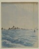
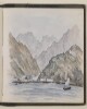
Genre/Subject Matter:This panoramic landscape view of a scene near Bushire [Būshehr] shows a flat plain with mountains in the background at left. A camp of white tents of varying sizes takes up the foreground at left; behind them a plantation of palms extend beyond the scene at far left. As the sun is setting at right, it seems likely that the view is roughly southwards.Temporal Context:Although the image dates from the Ouseley embassy 1810–12, the adjacent caption/description likely dates from c. 1880 and was written by later owner of the album, F. G. McCutcheon.Inscriptions:Recto:Lower right corner, in pencil: ‘27’Verso:Upper left, in pencil: ‘The Camp at Dalkie [Daliki] on the Road from Bushire to Shiraz’Adjacent inscription: ’27. Dalkee (one stage from Burazjoon) – The camp at Dalkee, a station near Bushire on the route from Bushire to Shiraz. There are sulphur springs in the neighbourhood.’ ‘Murray’s Guide p. 463.’1 watercolour drawing on paperDimensions:114 x 505 mmMaterials:Watercolour on paperCondition:Light surface dirt coats the recto and verso, with staining along all edges, particularly at right. The central fold is particularly stained and delicate, with signs of previous remedial work.
Reproduction of a black-and-white illustration depicting the view across a mountainous landscape. The Mafalis [Al Mafālīs] referred to in the title is a village, and is not obviously visible in the illustration.1 illustrationDimensions:150 x 250 mm.
Reproduction of an illustration of the port of Makalla [Al-Mukallā], as seen from the seaward side. The map is signed Lieutenant A L Paris, of the Royal Engineers, and dated 14 July 1902. A number of key buildings and other sites in the town (forts, towers, landing place) are highlighted.1 illustrationDimensions:250 x 330 mm.
Genre/Subject Matter:View of the ‘North Pass’, or Baab el Yemen, at Aden. This probably depicts a pass between the main British settlement at Crater and Khormakser. “Inside” may refer to the location the drawing depicts, or to the fact that it depicts the south side of the pass, i.e. within the British-controlled area.A path winds from centre foreground into a steep gulley; several barely sketched-in figures appear to walk along it. In the background at upper centre a bridge, viaduct or aqueduct is visible. At the top of the ridge at upper right a rectangular shape may indicate a man-made structure that leads down to the structure at centre.Inscriptions:Recto, in pencil, along lower edge: 'The North Pass of Aden or Baab el Yemen. “Inside”'Verso, in pencil, along upper edge: ‘WD3475’Temporal Context:This sketch was probably made between January 1939, when Stafford Bettesworth Haines seized Aden, and 1854, when he was recalled to Bombay to face embezzlement and fraud charges, during which time Haines administered Aden.1 pencil drawing on paperDimensions:128 x 185 mmMaterials:Pencil on paperCondition:Light surface dirt coats the recto and verso, but otherwise the paper is in good condition. A large stain in the upper-right corner is of unknown origin.
Genre/Subject MatterThis pencil sketch on paper depicts a man reclining against a pillow on a chaise-longue while reading. It is drawn in the style of a caricature, which is in keeping with other figural sketches in this volume and, more broadly, in the related files Mss Eur F140/232 and Mss Eur F140/233, which, together with this volume, complete the trio of journals created by Jeffrey C. Amherst.The man depicted is likely Captain Chamberlain, who Amherst cites as being ‘in command’ of B & D Companies upon his arrival at Aden on 30 November 1870. He is wearing at least one brace and holding the papers he is reading above his torso.The latter part of the inscription – ‘Marshag’ – refers to Ras Marshag, a promontory to the south of the Crater, upon which a lighthouse (built in 1861 to facilitate the navigation of increasing numbers of steamers passing through) was situated as well as the quarters for a detachment of infantry.InscriptionsUpper left corner: ‘Capt C at Marshag May 22nd 71’Temporal ContextThe drawing was made during the period Amherst was based at Aden, between 30 November 1870 and 1871/1872; on 5 February 1871, Amherst notes that he was in command of D Company and that he was based at the Isthmus Position, where two companies of British and two companies of Native Infantry were regularly based according to an 1877 publication (F. M. Hunter, An Account of the British Settlement at Aden, (London: Trübner & Co., 1877)). It seems Amherst moved about frequently between Crater, Isthmus, Ras Marshag and elsewhere during his time at Aden.1 drawing; pencil on paper, pasted into volumeDimensions:107 x 182 mm [landscape]Materials:Pencil on paperCondition:The paper is slightly foxed, but otherwise in good condition with adhesive still sturdy.Foliation:The image has been assigned a sequential number, 4, which is written in pencil in the lower right corner of the page onto which the image is pasted.
Genre/Subject Matter:Maritime view in the straits of Babelmandel [Bab-el-Mandeb]. A steamer is visible at left.Temporal context:This drawing was likely made during Henry Yule’s return journey to India with his new wife, Anna Maria White, in 1844.Inscriptions:Recto:Lower left, pen and ink: ‘Babelmandel Jany 1844’Upper right, ink stamp: ‘35’Verso:Centre, ink stamp: ‘India Office Library 12 Dec 1919’Upper right, pencil: ‘36’1 watercolour and ink drawing on watercolour paperDimensions:177 x 254 mmMaterials:Watercolour and pen on watercolour paperCondition:Thick surface dirt throughout and on recto with staining originating from adhesive on upper edge.
Reproduction of an illustration in black ink showing a panoramic view of the mountainous landscape west of the Wali Hassan shrine, in the direction of the town of Ad Dubiyat [Aḑ Ḑubayyāt]. Various hills, mountain peaks and other features are annotated with their transliterated names. Compass bearings are also given on some annotations.1 illustrationDimensions:250 x 520 mm.
Reproduction of a black-and-white illustration of a mountainous landscape, looking west towards Turkish territory from a pass at the head of the Wadi Hilhal. The map is annotated with various features, such as mountain peaks, valleys, hills and villages. The illustration is signed Major A Crawford and dated 7 May 1903. A note below the illustration states that it was produced from a hill approximately half a mile south east of the pass, and approximately 600 feet above it. The note also states that the positions and names indicated on the map were indicated by a guide belonging to the Ahmadi tribe.1 illustrationDimensions:210 x 340 mm.
Black and white reproduction of an illustration showing a view of the coast at Balhaf [Balḩāf]. The illustration is signed Lieutenant A L Paris, Royal Engineers, and dated 13 July 1902. The remains of the village, ruins, a tower, and the valley leading into the interior, are highlighted on the illustration.1 illustrationDimensions:150 x 248 mm.
Lithograph of a drawing by Samuel Butcher. The drawing shows the town and fort of Girash, looking southwest, after emerging from Tang-i-Masjidu pass. In addition to the town and fort it shows hills, watercourses and roads. Also shown is a date plantation surrounded by Gar trees and water cisterns.1 drawingMaterials: Printed on paperDimensions: 211 x 276mm
Reproduction of a black-and-white illustration of a mountainous landscape, the Radfān Hills, as seen from Wali Ḩassan. Various peaks and other landforms are annotated. Some annotations indicate compass bearings. The map is signed by Major J K Tod.1 illustrationDimensions:250 x 295 mm.
Genre/Subject MatterPencil sketch on paper.The sketch shows a maritime / topographical view of Jibel el Teer (Jabal al-Tair Island), a roughly oval-shaped volcanic island northwest of the Bab el-Mandab strait in the Red Sea.Two raised peaks are illustrated at the centre of the island, while the right of the island a curved cliff face appears to drop towards the sea.InscriptionsRecto, in pencil:Right edge: ‘137’Upper right corner: ‘Jibel el Teer – Red Sea. 13 Novr 1850’ ‘Lat: 15º 32’ N. Long: 41º55’ E.’Upper centre: ‘extinct Volcano’Temporal contextThis sketch is part of a series of six drawings over consecutive days, 11–13 November 1850, during the journey between Aden and the Red Sea.1 drawing on paper, pasted into volumeDimensions:165 x 280 mm [landscape]Format:Pencil sketch on paper, pasted into volumeCondition:The sketch is in good condition with surface residue throughout.Foliation:On paper: ‘137’On mounting paper ‘34’
Genre/Subject Matter:Maritime view in the Red Sea, at the northwest of the Bab el-Mandeb strait, of Gibel Tir [Jebel Al-Tair], meaning ‘bird mountain’.Temporal context:This drawing was likely made during Henry Yule’s return journey to India with his new wife, Anna Maria White, in 1844.Inscriptions:Recto:Lower right, pen and ink: ‘Gibel Tir’Upper right, ink stamp: ‘70’Verso:Centre, ink stamp: ‘India Office Library 12 Dec 1919’Upper left, pencil: ‘37’1 watercolour, pencil and ink drawing on watercolour paperDimensions:140 x 226 mmMaterials:Watercolour and pencil on watercolour paperCondition:Thick surface dirt throughout and on recto with staining originating from adhesive on upper edge.
Genre/Subject MatterPencil sketch on paper.The sketch shows a maritime / topographical view of Jibel Jan, which is likely to refer to Djebel Jan on the coast of latter-day Djibouti.The view was sketched from on board ship and shows a series of flat-topped islands leading away from the coastline on the right of the horizon.InscriptionsRecto, in pencil:Right edge: ‘135’Lower left corner: ‘Jibel Jan – 13 Novr 1850.’Temporal contextThis sketch is part of a series of six drawings over consecutive days, 11–13 November 1850, during the journey between Aden and the Red Sea.1 drawing on paper, pasted into volumeDimensions:162 x 270 mm [landscape]Format:Pencil sketch on paper, pasted into volumeCondition:The sketch is in good condition with scuffing in the upper right as well as some dark spot staining throughout and a purple stain in the lower left corner.Foliation:On paper: ‘135’On mounting paper ‘32’
Genre/Subject MatterPencil sketch on paper.The sketch shows two, presumably sequential, maritime / topographical views of a series of small islands in the Red Sea.The view was sketched from on board ship and shows eight or nine rocky islands. In the upper view, the sun can be seen going down or coming up behind the largest island. The island on the far left of the upper view may be identical with that on the far right of the lower view. Illegible inscriptions alongside each of these islands may be intended to indicate as such.InscriptionsRecto, in pencil:Right edge: ‘133’Lower left corner: ‘Isabera Islands – Red Sea – 13 Novr 1850’Temporal contextThis sketch is part of a series of six drawings over consecutive days, 11–13 November 1850, during the journey between Aden and the Red Sea.1 drawing on paper, pasted into volumeDimensions:162 x 280 mm [landscape]Format:Pencil sketch on paper, pasted into volumeCondition:The sketch is in good condition with only minor surface residue throughout and a number of small dark stains dotted across centre and lower left of the image.Foliation:On paper: ‘133’On mounting paper ‘30’
Distinctive Features:Tracing of a rough sketch map attached to letter no. 132 dated 11th April 1903 from Major Percy Zachariah Cox (folios 22-32) showing the position of Shaikh Abdulla bin Salim camp in the Eight Quarter of town.1 mapMaterials:Pen and ink with crayon on tracing clothDimensions:337 x 220 mm
The map is part of a printed report, prepared by Lieutenant William Henry Irving Shakespear, Assistant Resident and British Consul at Bandarabbas [Bandar-e ʻAbbās] in 1904, indicating the position of three flagstaffs erected in November 1903 at: 1) Musandam, close to the Elphinstone Inlet [Khawr ash Shamm]; 2) at Telegraph Island [Jazīrat al Maqlab]; 3) and at Sheep Island [Jazīrat Umm al Ghanam]. The map is printed in black ink, with the location of the three flagstaffs indicated in red. Below the title of the map, written in pencil, is ‘Musandim Peninsula’.1 mapMaterials:1 paper folio.Dimensions:333 mm x 193 mm.Foliation:The map is foliated in the top right corner with two folio numbers. The circled folio number should be used for referencing, while the uncircled folio number should be disregarded.
Distinctive Features:Hand drawn sketch maps enclosed with a copy of letter no. C-184 dated 23rd May 1938 (folio 89) showing the Fao estates owned by Shaikh Ahmad with occupants’ names typewritten and number of trees cut down marked in red.1 mapMaterials:Pencil with crayon on tracing paperDimensions:330 x 200 mm
The drawing is a rough sketch of a knee drawer table for the Political Resident in the Persian Gulf’s new office building at Bahrain, it includes a plan and elevation of the table, with measurements.The sketch is in pencil and blue coloured pencil.1 drawing
Genre/Subject Matter:View of the verandah of Haines’s bungalow at Ras Marbut [Ra’s Marbūţ] looking towards Little Aden. Haines sits facing away from the viewer at right, apparently sketching. His wife and another woman stand at centre in profile, looking out to sea. Several chairs, benches and a recliner are placed about the verandah.In the centre distance, the rocky peaks of Little Aden are visible. Two dhows, one steamer and a three-master are anchored or at sail in the bay.A latticework screen divides the verandah from the outside at left.Inscriptions:Verso, in pencil, along left edge: ‘Rough Pencil Sketch from the Point Bungalo Ras Marbut, Aden — Mrs Haines and Mrs [illeg]’Verso, in pencil, upper edge at left: ‘WD3479’1 watercolour and pencil drawing on paperDimensions:213 (longest edge) x 445 mmMaterials:Watercolour and pencil on paperCondition:Heavy surface dirt coats the recto and verso, especially at edges. The paper is cracked along the upper edge but has been stabilised by conservators. Unevenly sized paper.
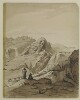
Genre/Subject Matter:The album contains fifty-eight watercolour landscape views of locations visited during the Ouseley embassy to Persia, 1810–12, as well as two handlists, probably created by later owner F. G. McCutcheon
c.1880, two notes from
The Graphicmagazine to McCutcheon and a newspaper clipping from
The Graphic, 1880.The watercolour drawings are on paper lightly tipped into the album. Titles and annotations made at a later date are pasted below the drawings and were probably written by McCutcheon. Titles on the versos of each drawing – where extant – are perhaps by D’Arcy himself, although they are also occasionally supplemented with further inscriptions, probably by McCutcheon.The drawings, numbered separately, have been mounted haphazardly and do not follow the route of the embassy. No. 15 is missing.The Ouseley embassy was a diplomatic mission during 1810-12 by Sir Gore Ouseley, Ambassador Extraordinary and Plenipotentiary to the Qajar court, to Fatḥ-ʿAlī Shah, which the British intended to use as an opportunity to collection intelligence about Iran while concluding the Anglo-Iranian Treaty of 1812.Elements:i) Handwritten ‘List of Water-Colour Drawings sketches in Persia by the late Lieut-Colonel D’Arcy. R. A. [Royal Academy] K.L.S. [Knight of the Lion and Sun of Persia] 1811–1812’, probably by F. G. McCutcheon, c. 1880, later owner of the album.1) ‘A ruined bridge near Mount Ararat, on the road to Constantinople’2) ‘Mount Ararat’3) ‘Greater & Lesser Ararat - Twilight’4) ‘Eklid [Iqlid], a Persian village’5) ‘Sion near Casibec – Caucasus’.[This drawing, outside the area of the Ouseley embassy and associated expeditions, may have been made when D’Arcy returned to England via Russia in 1815]6) ‘Scene in the mountains of Caraghehdaugh [Karadagh], Persia, where there is an Iron mine, Octr. 1812’.7) ‘Mount Sevilan [Savalan Dagh], 12,000 ft. high in Azerbijan’8) ‘Mount Sevilan [Savalan Dagh]. Even. Gt. storm coming’9) ‘Scene on the top of Mount Sevilan near the Crater’10) ‘View of the Ark from the Prince’s new garden, Tabreez, Figure is myself visiting the first Potatoe plants’11) ‘Tabreez, morning, from the suburbs’ and ‘will call for the sketch’ [This drawing was reproduced in
The Graphic, 13 November 1880. A copy is pasted at the back of the album.]12) ‘The back of the Ark and walls of Tabreez, the view is taken from the back of Hadjir Khan Mohammed’s Garden’13) ‘Kizil Uzen [Qizil Uzun]River’14) ‘The Kuflan Kow [Ghafilan Kuh] Bridge over the Kizil Osan [Qizil Uzun] or River of Golden Fish that separates Media from Persia. Col D’Arcy’. In another hand: ‘Kafilan - Kow Bridge’.15) [MISSING]16) Bridge, possibly over the Qizil Uzun near Haji Hamseh17) Large lake and distant mountains, possibly Lake Urumieh.18) ‘Prince Royal’s Camp, Sulstan Sissar [sic]. 12 Oct. 1812’, repeated in another hand.19) ‘Romantic Scenery near the Camp at Sultan Hissar – Oct. 1812’, repeated in another hand.20) ‘Persia, Wild scene about 5 miles to the N. of the Prince’s Camp at Sultan Hissar in Sept. & Oct. 1812, the high ridge in the centre of the picture is called the Lasllect Moyeran, in July 1814 I went there to see if a Fortress could be built on it. J.D’A’.21) ‘Amit Begloo [Dost‘Ali Begli]. Evg. 15 Oct. 1812’.22) Recto: ‘Camp near Amet Begloo [Dost‘Ali Begli]. Augst. 1812’. Verso: ‘From the camp at Ahmet Begloo’.23) Borazjun, on the route to Shiraz.24) ‘Berazgoon [Borazjun]’25) ‘The pass of Tangi Tourkon [Tang-i Turkhan] – halfway to Firoozabad’, repeated on original mount with ‘Farsistan’.26) ‘Entering the Kotils from Bushire’ [Note: Kotil or Kutal, a general word for high mountain pass]27) ‘The Camp at Dalkie [Daliki] on the Road from Bushire to Shiraz’28) ‘Abou-Shehr or Bushire, Persian Gulf’ / ‘On the road to Dalkin [Daliki] from Bushire showing the mirage’29) ‘Scene entering the Kotils from Bushire’.30) Recto: ‘Kotil Dokhtor [Kutal Dukhtar]’. Verso: ‘Kotil Dochter’ [Note: See Ouseley, vol. I, pl.XX.31) ‘View of the Salt Lake near Shiraz – seen from a valley beyond the Madrij Solimaun [Masjed Soleymān]’32) ‘View from the back of the Takhti Kadjar – Shiraz – Evening. The outlines of this view were hastily sketched in – on the last evening of our being there and the details put in since from other sketches and memory’33) ‘The Dariagh Namak – or Salt Lake – seen from the back of the Madre Solimaun [Masjed Soleymān]’34) ‘The rahdarri – or Toll station near Shiraz at the foot of the Madre i Soliman [Masjed Soleymān] – Salt Lake in the distance’35) ‘Scene just beyond the Shutur Khorah - shewing the Madre i Soliman [Masjed Soleymān], Salt Lake and pou i fassa, Shiraz’.36) ‘Ruins of the Shutur Khorah, or Camel stables near the gate of the Dilgusha, Shiraz’37) ‘View from the west of the Takht i Kajar, Shiraz looking towards the Salt Lake, April 1811’.38) ‘Shiraz, seen from the ground near the Moselleh [South]’39) ‘Diwan Khaneh or Hall of Audience of the Prince Royal at Shiraz, May 1811’.40) ‘Ruins of the Moseleh (Hafiz’s favourite retreat) near Shiraz, Persia’41) ‘The Hafiziah or Tomb of Hafiz – Shiraz’.42) ‘The Kou-i-barf (snow mountain) 5 miles N.W. of Shiraz, morning’. Also drawing of a bearded man.43) Mountain view with travellers and horses.44) A garden pavilion, Kulah-i Ferangi, Shiraz.45) Stony plain with toll gate and mountain ridge in the distance.45a) Distant view of Isfahan with a road, river and irrigation channel in the foreground. A fortified building to the right.46) ‘Kou-i-barf, hill of snow. A remarkable mountain near Shiraz’.47) ‘The approach to Comisheh [Qumisheh], one stage from Ispahan 1811’48).‘Comisheh [Qumisheh] on the road from Shiraz to Ispahan’.49) Distant view of the ruins of Persepolis from across the Kur, or Bandamir, river. [Note: Some members of the embassy visited Persepolis from 26 April to 7 May 1811, and the entire party reached it by 13 July of the same year.]49a) ‘Ruins of Persepolis viewed by twilight’ [Note: On reverse notes and drawing of a man studying inscriptions on a ruined pillar]50) ‘Ruins of Persepolis or Takhta Ghemshid [Takht-i Jamshrid] also Chehel Minar, Persia’.51) ‘A Pigeon Tower at an angle of the Hazar jereeb near Isphahan, the hermitage and Kuh-i-Sufeh in the distance’.52) ‘Entrance to Isphahan’53) Tombs of the Kings of Persia at Qum.54) ‘Bridge of Alli Verdi Khan [‘Ali Vardi Khan]. Isphahan’55) ‘The Bridge of Khajoo over the Zienderoode Ispahan’56) ‘The City of Ispahan from the Camp ground on the North’57) ‘The Shah’s palace to the N. of Tehran’58) ‘The Palace within the walls’ii) Handwritten ‘List of Sketches (Persia), probably by F. G. McCutcheon, c. 1880, later owner of the album.iii) Note from editor of
The Graphicto F. C. McCutcheon, owner of the album, 18 October 1880.iv) Cutting from
The Graphic, 13 November 1880, showing the reproduction of the sketch ‘Tabreez’ (11).v) Note from manager of
The Graphicto F. C. McCutcheon, owner of the album, 21 December 1880Inscriptions:Spine, gold embossed: ‘D’ARCY ALBUM’ ‘WD 1348’Page one, ink: ‘COLONEL D’ARCY DRAWINGS MADE DURING THE EMBASSY TO PERSIA 1810–12’Album of 58 watercolour drawings of views of Persia, Azerbaijan, Armenia and Turkey, mostly made during the Ouseley embassy to Tehran (1810–12), 1 newspaper cutting, 2 notes and 2 handlists (c. 1880) lightly tipped into a leather-bound album.Dimensions:Album: 518 x 642 x 63 mmFormat:Navy leather album with gold fleur-de-lys embossing containing fifty-eight watercolour drawings and other handwritten or printed paper items lightly tipped onto card pages.Materials:Ink, watercolour and body colour.Condition:The binding is in excellent condition while the individual drawings, while delicate, are in the main well secured in the album. Surface dirt throughout all drawings, with some minor additional staining.Foliation:The images have been numbered 1–58 in ink captions affixed beneath each image as well as in the lower right corner of each image, in pencil. Pages are foliated throughout in the upper right corner.Technique:Watercolour sketches.Binding:The album is bound in navy leather format with gold fleur-de-lys embossing. A gilt stamp has been applied to the spine upon acquisition to the India Office Library.
Lithograph of a drawing by Samuel Butcher. The drawing shows four different structures: a tower, a fort, a reservoir and a village, Zangu Mamelay.1 drawingMaterials: Printed on paperDimensions: 222 x 275mm
Lithograph of a drawing by Samuel Butcher. The drawing depicts mounds covering an ancient city about two miles southwest of Elseer in the Gillehdar valley. The drawing also indicates the site of a grave.1 drawingMaterials: Printed on paperDimensions: 222 x 255mm
Genre/Subject MatterPencil sketch on paper.The sketch shows a maritime/topographical view of a coastal region near or at the British Settlement at Aden in present-day Yemen.The view was sketched from on board ship and shows one dhow and seven other craft; one of the vessels in the foreground is a five-oared boat, with tiny pencil marks denoting figures on board. Along the horizon from the right to the left of the image jagged peaks give way to flatter-topped ranges extending down and out to the sea.InscriptionsRecto, in pencil:Right edge, 30mm from upper: ‘131’Lower left corner: ‘Chota Aden 11 Novr 1850’Temporal contextThis sketch is part of a series of six drawings made over consecutive days, 11–13 November 1850, during the journey between Aden and the Red Sea.1 drawing on paper, pasted into volumeDimensions:162 x 270 mm [landscape]Format:Pencil sketch on paper, pasted into volumeCondition:The sketch is in good condition with only minor surface residue throughout. One very light area of spot foxing appears along the left edge.Foliation:On paper: ‘131’On mounting paper ‘28’
Reproduction of an illustration in black ink of a rocky promontory and the village of Balas, Yemen. The map is signed Major A Crawford, Royal Artillery. Below the map is a dotted line indicating the new road from Karna [Qarnah] to Dala [Ḑāli‘].1 illustrationDimensions:250 x 340 mm.
Genre/Subject matterTwo pencil sketches on paper.The sketch on recto, sketched from on board ship, shows a landscape scene looking inland from the harbour at Aden. The range of hills or mountains in the background probably indicate Jebel Shamsan, or the Shamsan Range, often referred to as ‘Shum Shum’ or ‘Sham Sham’. A number of buildings have been indicated along the shoreline.The sketch on verso depicts a scene on the Danube, looking out across the river from an elevated position. A steamer can be seen in the lower centre foreground. Low hills can be seen in the background.The title indicates that the sketch was made at the site of Trajan’s Bridge, a Roman segmental arch bridge, constructed in 103–5 AD, that spanned the lower Danube between the shores of modern-day Romania and Serbia. Although the bridge was dismantled within two centuries of its construction, the entrance pillars on either shoreline were still visible and are indicated here along the left hand edge and immediately right of the centre of the image.InscriptionsRecto, in pencil:Upper right corner: ‘Aden 11. June going out of Harbour’Lower left corner: ‘101’Verso, in pencil:Upper right corner: ‘Trajan’s Bridge on the Danube. 16 June 1856’Upper centre: ‘317 1’2 pencil drawings on one sheet of paper, pasted into volumeDimensions:Album: 114 x 175 mm [landscape]Format:Two pencil sketches on paperCondition:There is extensive foxing on the left hand side of the image on recto as well as spot foxing throughout. On verso surface residue is evident as well as low-level spot-foxing throughout and in the right of the image in particular.Foliation:Recto: ‘101’ [sic]Verso: ‘317 1’
Genre/Subject Matter:This incomplete pencil sketch shows the harbour at Aden from on board ship. Jagged peaks – described as volcanic on the verso – line the horizon from left to right with two smaller spits of rock jutting into view at either side of the scene.A three-master is indicated at anchor at left while a small row boat is just left of centre.Inscriptions:Recto:Along lower edge, L to R, in pencil: ‘Aden’; ‘[illegible]’; ‘Jun 3rd 1839’; ‘Aden – port as seen on approach from Bombay’Verso:Along lower edge, in pen: ‘Aden on Arabian Coast. Red volcanic rocks – lately taken by E. I. Company troops’Upper left, in pencil: ‘150’1 pencil drawing on paperDimensions:165 x 222 mmMaterials:Pencil and pen paperCondition:Thick surface dirt throughout, especially on recto
Lithograph of a drawing by Samuel Butcher. The drawing depicts ancient ruins, as well as fortifications on the crest of hills, including the Fort of Lar. Also shown are a tomb with a dome, a Mohammidan [Muslim] shrine, and an irrigation trench.1 drawingMaterials: Printed on paperDimensions: 228 x 274mm
Genre/Subject Matter:This printed pen sketch shows the town of Fao in latter-day Iraq and was probably sketched from on board ship. A flagstaff to the left of the image probably denotes the location of the telegraph station and post office. Fao is described as ‘the Turkish town’ on p. 7 of the same volume; this is indicated by the ay-yıldız (star and crescent) indicated on the flag atop the flagstaff.Inscriptions:Printed, below image: ‘FAO Telegraph Station and Post Office’1 printed sketch pasted on paperDimensions:130 x 193 mm; 129 x 195 mmCondition:The prints are in good condition with minor transfer from opposite printe page and surface dirt throughout. Some light foxing and creasing at edges.Foliation:‘23’
Distinctive Features:Relief shown by hachures and spot heights. Depths shown by soundings.Nautical chart showing the entrance of the Persian Gulf and the Musandam Peninsula with details on hazardous features and tides given.Title inserted in hand below map.1 mapDimensions:170 x 145 mm, on sheet 340 x 200 mm
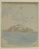
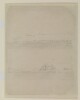
Genre/Subject Matter:This landscape view of a scene near Bushire [Būshehr], shows a winding roadway, river and mountains in the distant background. A man on a horse rounds the corner of the winding path in the middle distance.Temporal Context:Although the image dates from the Ouseley embassy 1810–12, the adjacent caption/description likely dates from
c.1880 and was written by later owner of the album, F. G. McCutcheon.Inscriptions:Recto:Lower right corner, in pencil: ‘26’Verso:Upper right corner, in pencil: ‘Entering the Kotils from Bushire’Lower right corner: ‘26’Adjacent inscription: ’26. Entering the Kotils from Bushire.’1 watercolour drawing on paper
Genre/Subject Matter:This printed pen sketch shows Maskat (Muscat) from the harbour entrance and was probably sketched from on board ship. Three small boats are in the foreground while a steamer is visible closer to shore. A fort on an outcrop of land to the left of the image is probably Al Jalali Fort.Inscriptions:Upper right corner, above image in pencil: ‘23’Printed, below image: ‘Maskat from the Harbour entrance’1 printed sketch pasted on paperDimensions:130 x 193 mm; 129 x 195 mmCondition:The prints are in good condition with minor transfer from opposite printe page and surface dirt throughout. Some light foxing and creasing at edges.Foliation:‘23’
Reproduction of a black-and-white illustration of a mountainous landscape, seen from near the top of Jabal Mafārī, towards the Azraki [Azāriq] Valley and Jabal Mashwara [Maswarah]. The original illustration was drawn by Major J K Tod, from photographs supplied by Naik Shekh [Shaikh] Imamuddin.1 illustrationDimensions:210 x 340 mm.
Reproduction of an illustration in black ink showing a panoramic view east from the summit of Jabal Harir [Jabal Ḩarīr] in Yemen. Various mountain peaks, hills and valleys are annotated on the map with their transliterated names. Some features are annotated with compass bearings. The map is signed Major J K Tod, and dated February 1902.1 illustrationDimensions:250 x 550 mm.
Black and white reproduction of an illustration of mountainous terrain, seen from J Abab [Jabal ‘Abbāb], with the Tiban Valley [Wādī Tiban] in the foreground. The most prominent peaks are labelled with transliterated names, and in some instances also with compass bearings. The illustration is signed Major J K Tod, and dated March 1903.1 illustrationDimensions:250 x 550 mm.
Reproduction of an illustration of mountainous terrain, seen from At Thamer [Thamar], near Jimell [Jamal], Yemen. Prominent topographic features (mountain peaks, valleys) are annotated, most with transliterated names, some with compass bearings.1 illustrationDimensions:250 x 550 mm.
Black and white reproduction of an illustration of mountainous territory on the Anglo-Turkish boundary. Significant hills and summits are marked as either being in British (B) or Turkish (T) territory, or being on the boundary itself (BO).1 illustrationDimensions:250 x 550 mm.
Genre/Subject Matter:This landscape view of a scene near Bushire [Būshehr] shows a trail winding from left towards high mountain ranges in the background. A large expanse of water – perhaps a river – snakes from right to centre around a bank jutting towards the centre of the image.Temporal Context:Although the image dates from the Ouseley embassy 1810–12, the adjacent caption/description likely dates from
c.1880 and was written by later owner of the album, F. G. McCutcheon.Inscriptions:Recto:Lower right corner, in pencil: ‘29’Verso:Upper right, in pencil: ‘Scene entering the Kotils from Bushire’Lower right corner, in pencil: ‘29’Adjacent inscription: ‘29. Scene on entering the Kotils from Bushire. The Kotils are a range of mountains between Bushire and Shiraz’1 watercolour drawing on paperDimensions:236 x 338 mmMaterials:Watercolour on paperCondition:Light surface dirt coats the recto and verso, with staining along all edges. Two small puncture holes at upper left and right corners indicate that the drawing was at one time pinned up.
Black and white reproduction of an illustration showing a view of the Tiban valley [Wādī Tiban] from Lijma [Al Lijmah], with the peak of Jabal Warwa in the distance. Human figures standing in and alongside the river provide scale to the scene.1 illustrationDimensions:100 x 147 mm.
Reproduction of a black-and-white illustration showing the view from the village of Al Kabar. The illustration, signed by Major J K Tod, shows an expanse of plain surrounded by mountains. Some of the mountain peaks are annotated with transliterated names. Compass bearings run along the top of the illustration.1 illustrationDimensions:250 x 850 mm.
Reproduction of a black-and-white illustration depicting a mountainous landscape near the village of As Sueda [As Suwaydā’] in the Mafārī Uzlat. Various peaks are annotated. The illustration is signed Major J K Tod.1 illustrationDimensions:250 x 670 mm.
Black and white reproduction of an ink illustration, a panoramic view of the terrain from Jabal Hesha, on the left-hand side of the view, to Jabal Shem on the right-hand side. The chief hills are annotated, as are some other topographic features. A note at the bottom of the map states that cultivated areas are indicated with horizontal hatched lines.1 illustrationDimensions:215 mm x 1400 mm.
Reproduction of a black ink illustration of the coastline at Bab-Al-Mandab [Ra’s Bāb al Mandab], with the Shekh Said [Shaikh Sa’id] hills in the background, as seen from Obstruction Point on Perim Island. Headlands and prominent hills are annotated.1 illustrationDimensions:250 x 240 mm.
Genre/Subject MatterPencil sketch on paper.The sketch shows three, presumably sequential, topographical views of the coastal region at the Bab el-Mandeb strait (12° 34' 34” North, 43° 21' 11” East) between Arabia (Yemen) and Africa (Djibouti and Eritrea). This strait, consisting of a two-mile wide eastern channel and a sixteen-mile wide western channel separated by Perim Island, connects the Red Sea with the Gulf of Aden and the Indian Ocean.The views were sketched from on board ship. The central sketch shows the profile of Perim Island, while the upper sketch appears to show a flare or beacon of some kind, with thick smoke billowing from its peak. This object is inscribed ‘Shrinka’. A number of other inscriptions, some of which are illegible appear to denote certain parts of the evidently rocky strait.InscriptionsRecto, in pencil:Upper centre: ‘Shrinka’Left edge: ‘2nd’, ‘3rd’Centre: ‘W’Right edge: ‘129’45 mm from right, 70 mm from upper: ‘Perim Island’30 mm from left, 35 mm from lower: ‘1st’Lower left corner: ‘Straits of Babelmandel. 12 Novr 1850.’Temporal contextThis sketch is part of a series of six drawings over consecutive days, 11–13 November 1850, during the journey between Aden and the Red Sea.1 drawing on paper, pasted into volumeDimensions:160 x 278 mm [landscape]Format:Pencil sketch on paper, pasted into volumeCondition:The sketch is in good condition with only minor surface residue throughout as well as one small area of staining on the lower edge, likely from the adhesive.Foliation:On paper: ‘129’On mounting paper ‘26’
A sketch showing the siting of Gwadar landing ground. The sketch is part of a letter (f 20) sent by Charles Clark Mylles, Assistant Manager at the Anglo-Iranian Oil Company Limited, to the Political Resident in the Persian Gulf, Bushire.1 drawingMaterial: coloured pencils and black ink on tracing paperDimensions: 327 x 245mm, on sheet 360 x 257mm
Genre/Subject Matter:View of a mosque or mausoleum at Aden, which may be an earlier incarnation of the Mosque of Abu Bakr al-‘Aydarus. The original building was constructed in the fifteenth century but heavily reconstructed at some point in the nineteenth century, perhaps after this sketch was made. The artist indicates the connection with al-‘Aydarus in the inscription in pencil which reads ‘Sheik Hydroos [Aydroos]’Several figures are sketched in at the entrance to the mosque; a flagstaff appears immediately outside it. Behind the building the faint lines of a step rocky outcrop have been indicated.The sketch is signed lower right with the initials of the artist.Inscriptions:Recto, in pencil, along lower edge: ‘Sheikh Hydroos’Recto, in pen, along lower edge: ‘A Mussulman Temple – Aden. SBH.’Verso, in pencil, along upper edge and lefthand edge: ‘WD3476’; ‘Plan of Aden No. 2’Temporal Context:This sketch was probably made between January 1939, when Stafford Bettesworth Haines seized Aden, and 1854, when he was recalled to Bombay to face embezzlement and fraud charges, during which time Haines administered Aden.1 pencil drawing on paperDimensions:140 x 204 mmMaterials:Pencil on paperCondition:Light surface dirt coats the recto and verso, but otherwise the paper is in good condition. A large stain in the upper-left corner is of unknown origin.
Imprint:General Staff India.Distinctive Features:View of battle of Nasiriyah produced to illustrate
'Report from Gen Sir John Eccles Nixon’ showing the line of the British and enemy’s
tranches with landmarks labelled for reference.Below title: ‘View from the Enemy’s point of view –
looking South – from point 200 yards North-east of B’.Marked ‘For Official Use Only’.In the left-hand corner: ‘S.D.O. No. 1353, September,
1915’.1 viewDimensions:210 x 570
mm
Imprint:General Staff India.Distinctive Features:View of battle of Nasiriyah produced to illustrate
'Report from Gen Sir John Eccles Nixon’ showing the point reached by the British
Infantry on the night 24-25th July 1915 with landmarks labelled for reference.Marked ‘For Official Use Only’.In the left-hand corner: ‘S.D.O. No. 1351, September,
1915’.1 viewDimensions:200 x 215
mm
Imprint:General Staff India.Distinctive Features:View of battle of Nasiriyah produced to illustrate
'Report from Gen Sir John Eccles Nixon’ showing the position of the British and
enemy’s tranches with landmarks labelled for reference.Below title: ‘View of Battlefield, 24th July 1915, from
Divisional Head Quarters 2, Looking N,N.W.’.Marked ‘For Official Use Only’.In the left-hand corner: ‘S.D.O. No. 1352, September,
1915’.1 viewDimensions:170 x 295
mm
Reproduction of a black-and-white illustration showing a blockhouse, or fort, overlooking a river valley. The illustration subtitle states that the site is at Ghail Hardaba [Ḩaḑabah], 16 miles south of Dala [Aḑ Ḑāli‘]. The map is signed Major A Crawford, and dated 6 December 1903. Key topographical features are annotated, and in the bottom-right corner of the illustration is a small plan of the fort, showing the location of its entrance door.1 illustrationDimensions:250 x 330 mm.
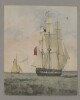
Genre/Subject Matter:The album contains landscape views of locations along the Indian coast from Calcutta to Bombay, as well as at Aden and along the Red Sea coast. The watercolour drawings are rendered directly onto watercolour paper and captioned in ink, usually on the verso of the preceding folio, though at times along the lower edge of the drawing itself.The images date from a honeymoon trip taken by Toynbee between 1879 and 1880 on a British India steamer from Calcutta to Bombay. Thereafter, Toynbee stayed in Bihar with friends, including George Toynbee (probably her brother-in-law), joint Magistrate and Deputy Collector at Patna. Toynbee continued to depict landscapes along her route home along the Arabian and Red Sea coastlines as well as at Suez.Elements:1 ‘Farewell to Orissa? False Point’2a ‘Gopalpore [Gopalpur Odisha]’2b ‘Pillar; said to be of date of Asoka (by[?] 200 B.C.) now surmounted with Lantern & used as a Lighthouse.’3 ‘Calingapatam [Kalingapatnam].’4 ‘Bimlipatam [Bheemunipatnam]’5 ‘Vizagapatam [Visakhapatnam]’6 ‘Chinnapatna (Madras. [Chennai])’7 ‘Negapatam [Nagapattinam]’8 ‘Galle [Sri Lanka]. P & O. Agent's House’9 ‘Colombo [Sri Lanka]’10 ‘Cape Comorin (Cunnea Comnari) [Kanyakumar]’11 ‘Alleppy [Alappuzha], Travancore’12 ‘Calicut [Kozhikode]’13 ‘Tellicherry [Thalassery]’14 ‘Cannanore [Kannur]’15 ‘Carwar [Carwar]’16 ‘Rutnagherry [Ratnagiri]’17 ‘Bombay’18 ‘Arrah [Bihar; probably the Collector's Bungalow]’19 ‘Dehree on Sone [Dehri], looking towards Sasseram [Sasaram, Bihar]’20 ‘Geo: Toynbee's House, Bankipore.’21 ‘Ganges Flood at Bankipore [Bihar]’22 ‘Patna Golah, Bankipore [Bihar]’23 ‘Zoological Gardens, Calcutta’24 ‘Pondicherry [Puducherry]’25 ‘Galle, Ceylon [Sri Lanka]. looking S.E.’26 ‘View looking N.E. from Wakwalla [Wakwella], Galle, Ceylon, River Ginjura [Gin Ganga] in distance’27 ‘Aden’28 ‘Red Sea, looking (6 a.m.) towards Horeb & Sinai’29 ‘Suez’Inscriptions:Spine, gold embossed: ‘WD 1348’Inside front cover:In pencil: ‘India Office Library 1348’In pen: ‘Guy Ellistone Toynbee From Aunt Kate 29th March 1902’Letter press label: George Squire, Late Bowden & Co. Artists’ Colourman, 314 Oxford Street’First fly leaf:In pen: ‘Dear Hall. I do hope these old sketches will interest you. If they do please keep them ~ W. [illegible]’‘From Calcutta to Bombay (by B. I. steamer).’Further inscriptions in black ink (now faded) – made by the artist, presumably at the time of production – are to be found on the verso of each folio and in some instances at the lower edge of the sketch itself.Inside back cover, in pencil: ‘India Office Library’Album of 29 drawings of views along the Indian coast from Calcutta to Bombay, and of views in Bihar, Calcutta, Aden and Suez.Dimensions:Album: 150 x 235 x 12 mmFormat:Black and brown half leather album containing twenty-nine watercolour drawings rendered directly onto watercolour paper pages.Materials:Watercolour paper, black ink, watercolour and body colour, letterpress stamp.Condition:The binding is still sturdy – aside from extensive scuffing and losses at all edges and a tear along the spine – the individual folios are in good condition, with only minor welling and some light surface staining throughout. Light transfer of pigment from the recto is evident on the verso of each previous page.Foliation:The images have been numbered 1–29 in the upper right corner of each page, except for image 2b, which appears on the verso of image 2(a).Technique:Watercolour and perhaps bodycolour sketches.Binding:The album is bound in black and brown half leather format, which is heavily scuffed along the spine. A gilt stamp has been applied to the spine upon acquisition to the India Office Library.
A drawing showing the proposed extension and road diversions to Beit Al-Falaj Royal Air Force landing ground. The whole site of the landing ground is sketched with pencil, whereas the proposed extension area is sketched in red ink. This has been surveyed by Captain E G Fitzhenry, Section Officer A. M. W. D. Basrah.1 drawingMaterials: contact print with manuscript additions in coloured ink, pencil and crayon.Dimensions: 700 x 390mm
Reproduction of a black-and-white illustration of Wadi Hidaba [Ḩidābah], at the well above Al ’Ashar [Al Ashār]. An encampment of tents fills the bottom of the valley, giving a sense of scale to the scene, which has the Juheli [Juḩaylī] hills in the background.1 illustrationDimensions:150 x 250 mm.
Reproduction of a black-and-white illustration depicting the view across the Wadi ’Ubil at Mijza [Al Mijza‘]. Notable features of the landscape (hills, buildings, streams, boundary crossings) are annotated.1 illustrationDimensions:250 x 550 mm.
Reproduction of a black-and-white illustration depicting the view across the Wadi Ma’din [Ma‘ādin] from Sanawī. Prominent geographical features beyond the wadi are annotated.1 illustrationDimensions:150 x 250 mm.
Reproduction of a black-ink illustration depicting the view across the Wadi Ma’din [Ma‘ādin], looking eastwards from near Sanawī. Prominent geographical features beyond the wadi are annotated.1 illustrationDimensions:158 x 318 mm.
Reproduction of a black-and-white illustration of a gorge and stream in Wadi Ziyak [Ziyaq], near Haushabi [Ḩawshabī], Yemen. Two camels and a human figure, drawn at the bottom of the gorge, provide a sense of scale to the illustration.1 illustrationDimensions:210 x 300 mm.
Genre/Subject MatterPencil sketch on paper.The sketch shows a maritime / topographical view of a coastal region, presumably along the Red Sea or Arabian coastline.The view was sketched from on board ship and shows two dhows and one smaller craft sailing from right to left across the scene. In the background a coastal hill is in shadow while further hills in the distant background are briefly indicated.InscriptionsRecto, in pencil:Right edge: ‘130’Temporal contextThis sketch is part of a series of six drawings over consecutive days, 11–13 November 1850, during the journey between Aden and the Red Sea.1 drawing on paper, pasted into volumeDimensions:165 x 271 mm [landscape]Format:Pencil sketch on paper, pasted into volumeCondition:The sketch is in good condition with only minor surface residue throughout. Several areas of spot foxing appears along the left edge, while one area of spot foxing is apparent near the right edge.Foliation:On paper: ‘130’On mounting paper ‘27’
Genre/Subject Matter:The album contains one hundred and fifty-four landscape views and studies in watercolour and pencil of locations and subjects encountered between 1834 and 1839. The majority are inscribed with notes, dates and captions by the artist. Some inscriptions are in a later hand.The drawings are rendered onto paper and were lightly tipped into the album after acquisition. A further nine drawings, WD3111–3119 have been mounted separately, as are six drawings by Indian artists, Add. Or. 3167–3172.Elements:f. 1a Inscribed on reverse: ‘His Majesty’s experimental frigate Vernon drawn at sea Jany. 10th 1834 in Persian Gulf’f. 1b Inscribed on reverse: ‘View of the hills containing the Caves of Ellora, from the Village. Feby. 20 1834’f. 2a Inscribed on reverse: ‘Hyder. Capt O’s & Boyd’s Elephant, Feby. 26th 1834. Ajanta’Note: See ‘Travels’, I, pp.23–5, Captain James Outram, 23rd Bombay Native Infantry, Captain George Boyd 2nd Bombay Native Infantry.f. 2b Tiger’s head. ‘From nature at Indore’f. 2c ‘Tigress [from] nature’f. 3a The fort, Asirgarh, with three sepoys of the Bombay Native Infantry in the foregroundInscribed on reverse: ‘Assieghur. March 20th 1834, Kandeish’.f. 3b ‘Hall of Indian Sepahis. Nusseerabad’Inscribed on reverse: ‘Dhooli near Nusseerabad. April 24th 1834’.f. 4a ‘Indian Antelope from nature’Inscribed on reverse: ‘Head of a Goat Antelope from nature. Ajmere May 3rd 1834’.f. 4b Inscribed on reverse: ‘Ajmere. May 4th 1834’f. 5a Inscribed on reverse: ‘Approach to the Himala near Pinjore June 2nd 1834. Morning. On way to Simla’f. 5b Inscribed on reverse: ‘Kotghur between Simla & the snowy range. View of the Sutlege 4000ft. below. June 22nd 1834. Sunset’f. 6 ‘Major Kennedy’s house. Simla’Note: Major C.P. Kennedy, Political Agent, Simla.f. 7a Rana of Keonthal. Head study. ‘Rana Sumsat Sing of Keyontherl. Hill Rajah near Simla’f. 7b Hillman. Head study. ‘Near Simla’f. 7c ‘Women of Vill. of Serai under Chur mountain near Simla. Him. Mountn’f. 8 Inscribed on reverse: ‘Waterfall. Simla’f. 9 ‘Simla from Jacko’f. 10a Inscribed on reverse: ‘Atop of Chur Oct. 10th 1834’f. 10b Head studies of two hill children. ‘Bhodia. Neoli. Oct. 12th 1834. Himalayas. Simla’f. 11 Inscribed on reverse: ‘Over the Tonz-bridge near Missuri. Himaya. 14th Oct. 1834’f. 12 Inscribed on reverse: ‘Dera Dhoon from Hati Paon Missuri. Nov. 18th 1834’f. 13 Inscribed on reverse: ‘Bridge below Missuri Himalaya’f. 14 Distant view of HardwarInscribed on reverse: ‘Hurdwar - Ganges entering plains’f. 15a ‘Indian Dwarf. Boodh Ram. Height 39 inches aged 50. Agra. Jany. 17th 1835’f. 15b ‘Indian Rat. Bandercoot Feby. 15th 1835’f. 15c Mirza Anjum Shukoh, grandson of Akbar II. Head study. ‘Mirza Unjim Shiko Bahadur March 10th 1835. Prince of House of Delhi’Note: Vigne was present at the marriage of the prince to the granddaughter of William Linnaeus Gardner, founder of Gardner’s Horse, see ‘Travels’, I, pp. 40–44.f. 15d Lynx and fox. ‘Khass Gungi. Carical & fox from Nature. March 13th 1835’f. 16 ‘Indian children, Cutchora. April 7th 1835’f. 17 ‘Nashautal Begum. Mulka Begum’s daughter’Note: Mulka Begum was married to James Gardner, son of William Linnaeus Gardner.f. 18 ‘A Celebrated Indian Decoit April 8th 1835’f. 19a ‘Havildar of my Sikh guard. May 16th 1835 Jewalee’f. 19b ‘Him Mtns at Jewalee. Young Brahmin May 17th 1835’f. 19c ‘Capt Wade’s house Loodiana’ and on reverse: ‘Captn. Wade’s House, Loodiana. May 18th 1835’Note: Captain Claude Martin Wade, Diplomatic Agent, Ludhiana 1823.f. 20a ‘Faquir. June 13th 1835. Lower Range of the Him Mns’f. 20b ‘Amaluk Ram. Governor of Nurpore Panjab. June 19th 1835’f. 20c Figure studies. ‘Kessundpore. June 23rd 1835’f. 21a Cow and unfinished landscape. ‘Samurtee. June 24th 1835 at foot of the higher mountains. Panjab’f. 21b ‘Pundit at Maunsa Lower Range Him. Mns. June 24th 1835’f. 21c ‘Suko. Maunsa. June 30th 1835. Peasant. Lower Range Himalayas’f. 21d Two head studies. ‘Comt. of Artillery to Rajah Gulab Sing of Jammu. Him. Mtn’f. 21e Head study. ‘Meer Lena Sing. June 30th 1835 at Serror Surdee near Jammu, Him. Mtn. and Indian child. Him. Mtn’f. 22a ‘Him. Mtneer. Kasor, name Merasi. July 1st 1835’f. 22b Punjabi woman. ‘July 31st 1835’f. 22c ‘Peasants. Lower range Him. Mtns. Name Nickar. Koonja. July 5 1835’f. 22d ‘Mulka (name) Aumdra. July 5th 1835. Mountaineer Him. Mont. Mujhta/Sepahi. Aumdra. July 5th 1835. A Sikh Sepahi of the Him. Mount’f. 23a Animal studiesf. 23b ‘Faquir, lower range Him. Mtn. namana Shah Faquir Termsal. July 7th 1835’f. 23c Two head studies of children. ‘Abnasse Ram Termsal Oodapee. Termsal July 8th 1835’f. 23d Head study. ‘Girl of Rajt. County. Hm. Mnt’f. 23e Unfinished drawings of temple and European house. ‘Maundpora July 20th 1835. Earthquake’f. 23f ‘Lol Gholam July 17th 1835, looking S.W.W. Lol Gholam, Red Slave tower, on pass to Kashmir over the Pir Panjal. Saracenic.f. 24a ‘Isle of Chenars. Make the reflections very bright. Chahar Chenar to the North. Cashmere Augt. 3rd 1835’Note: See ‘Travels’, II, facing p.104.f. 24b Wooded island, Kashmirf. 25 Two unfinished pencil drawings of the Shalimar gardensf. 26 Unfinished drawing, Shalimar gardensf. 27 ‘Augt 19th 1835 Base of the pillar in the Shalemar Cashmere of black polished marble. Said to be Saracenic or copied from Hindus/?/GTV’f. 28a ‘Approach to Jhelum. Aug. 21 1835 Log. N. East. Gate of the Shalimar in ruins. Kashmir’f. 28b Cave in side of rock, Kashmirf. 28c ‘Ornaments on Temple of the Sun at Martund Kashmir’f. 29a ‘Chalon’s Flora McIvor in Kashmir Costume’Note: See ‘Travels’, II, p. 234f. 29b ‘Kashmiri Boatwoman’f. 29c Side and back view of Kashmiri woman and headdress, with notes on costume detailsf. 29d Head study. ‘Kashmir Gurys’f. 30a Landscape.f. 30b Ewers and bowls, a root and berried plant. ‘A creeper like a strawberry plant at 11000 feet high in a dry bog’f. 30c ‘Dog of Chantan. Sept. 12th 1835. Black & Tan’f. 31 ‘Mohd. Ali Khan. Rajah of Royul on the Indus. Sept. 12th 1835. Little Tibet’f. 32 ‘Shigha. S.E. Front Sept. 14th 1835. Looking S.W.S. towards Iskardo’f. 33a ‘Tibet Dancing’f. 33b ‘Ameer Hyder son of Ah[mad Shah] of Little Tibet aged 12. Ameer Hyder Achmet Shah’s son. September 28th 1835’Note: Ahmad Shah was the last of the independent Rajas of Baltistan.f. 33c ‘Moonshee Mohammud Shah. Oct. 4th 1835. Moonshie & Principal Counsellor of Ahmud Shah of little Tibet, a Kashmerian’f. 33d Village house. ‘Paharee. Oct. 4th 1835’f. 34a ‘Old Pillars at Derass. Oct. 15th 1835. Lg. N.E. 5 feet high’ and on reverse: ‘On pass from Kashmir to Tibet’f. 34b ‘Lg. N.W. Oct. 16th 1835 Derass. Castle of ditto’f. 35a Camp scene in mountain landscape. ‘Paien Iqphal. Oct. 18th 1835 Lg. E’f. 35b ‘Kulun Kashmir. Oct. 20th 1835. Kashmiri Cottage.’f. 36 ‘Chula Waterfall. 2nd day from Baramulla Dec. 10th 1835’f. 37a ‘Kathai. Decr. 15th 1835 Lg. E. nr. Baramula Pass’f. 37b Head study. ‘Ferryman. Attock River’f. 37c House. ‘In the Plains near Rawal Pindee Lg. N.W. Dec. 29th 1835’f. 37d Village scene. ‘Punjab in the plains lg. E. Dec. 27th 1835 Shemsherabad’f. 38 Standing figure playing a tambura. ‘Faquir Bunga North of Lahore Jany. 22d 1836’f. 39a Head and shoulders study. ‘Mackeson. gold band and tassel and pink velvet cap’Note: See ‘Personal narrative’, pp. 257–8. Frederick Mackeson (1807–1853), acted as interpreter for Vigne when he met Ranjit Singh at Lahore.f. 39b ‘Gen. Ventura with the Sikhs’Note: See ‘Personal narrative’, pp.257–8. J.B. Ventura served Ranjit Singh and the Sikhs from 1822 to 1843.f. 39c ‘Sikh riding at a tent peg’f. 39d Head study. ‘Sikh dancing girl Lahore’f. 39e ‘In attendance. Kissen Chund. Runjeet’s late envoy at Lodiana’Note: See ‘Personal narrative’, pp.6, 13, 247f. 39f Horse. ‘Sheitabad April 3d 1836’f. 40a ‘Sleeping figures. Halt of Lohani caravan’Note: See ‘Personal narrative’ p. 26f. 40b ‘Ameer Khan Lohannee. May 6th 1836. Musajye’. Head studyf. 40c,d Miscellaneous animal studiesf. 41a ‘Source of the Jelum. Sinbul. N.E.E. Dec. 15th 1836’f. 41b ‘Top of Poonch Pass to Kashmir. Height 9500 ft. Pir Panjul. Lg. N.N.W. Dec. 29 1836’f. 42a ‘Taken on the Poonch Pass near Hyderabad. Dec. 29th 1836 Lg. N.E.’f. 42b ‘Moolah at Thuna Jany. 2d 1837’f. 42c ‘Runjit’s great Elephant’Note: Vigne spent March and April 1837 at the court of Ranjit Singh during the celebrations for the wedding of Nau Nihal Singh.f. 43a ‘Rantree near Poonch. May 5th 1837. Lg. N.E.’f. 43b ‘Sistri Daramsal. May 12th 1837. near Baramula Lg. S. nearly’. Stone pillar. ‘Near Patun. May 13th 1837 Lg. N.W.’f. 44a ‘Sleeping Bear Oct. 26th 1837. Brown bear of Cashmere. Done from nature with real effect’f. 44b Head study. ‘A Kashmerian dancing girl Oct. 27th 1837’f. 45a ‘Boat girl of Kashmere. Nov. 7th 1837’f. 45b Miscellaneous drawings. ‘Dec. 26th 1837’f. 46a ‘Hindu Sculpture Kashmere. Lachme or Dri’f. 46b Head study. ‘Old man of Little Tibet. Ali Nur Shyger Augt. 25th 1838’f. 46c Head study. ‘Budukshanee. Little Tibet. Oct. 16th 1838’f. 46d ‘Man of Little Tibet’f. 47a ‘Duri Bul. Manasa Bul. Looking N.N.E. Kashmir’f. 47b Mountain range. ‘Nov. 15th 1838 Lg. S.S.E. for view above Big Beas’f. 47c Miscellaneous views. ‘In the Punjab Himalayas. January 1838’f. 48a Head study. ‘Nikree a reputed Deynor witch Budrawar. Jany. 19th 1839’f. 48b ‘Mendu. 8 inches high. Dog of the H. Mtns. Jany. 31st 1839. Acheghur’f. 48c ‘Ferry at Bissaula on the Ravi. Feb. 1st 1839 Lg. N.E’f. 48d ‘Young Paharee Girl. Khu bettn. Bissaula & Chumbah. Feb. 2nd 1839. Peast. Girl of Him. Mtns’f. 48e ‘The Jumping pillar. Feb. 11 1838 Chumbah’f. 49a ‘Surnee woman of vill. of Roualni Tikree near Chumbah. Him. Mountains. From the only village in the Alpine Panjab where the women wear turbans. Feb. 12th 1839’f. 49b ‘Peasant of Chumbah. Him. Mtn’f. 50a Studies of bears. ‘At Kangrah. Feb. 20th 1839’f. 50b ‘Fakir at Jewala Muki in the Alpine Panjab’f. 51a ‘At Dyur-crossg. the Sutlej on inflated buffalo Hides’f. 51b Head study. ‘Boatman on the Sutlej at Bawhulpore where Sir Charles Napier’s army is going into Cantonments for the hot weather. April 7th 1839’f. 52a–f Miscellaneous figure studiesf. 53a–d Miscellaneous animal and figure studiesf. 54a,b Studies of sheep. ‘Sheep Alpen Panjab’f. 55a–c Studies of cattlef. 56a,b Miscellaneous animal and figure studiesf. 57a Bear cub and puppyf. 57b Hunting leopardf. 57c Elephantf. 58 Camel. ‘Sewree. Messenger Camel’f. 59a–c Miscellaneous drawings including musical instrumentsff. 60–62 Unfinished landscapesf. 63a ‘Aden. Port as seen on approach from Bombay June 3d. 1839’ and on reverse: ‘Aden on Arabian coast. Red volcanic rocks. Lately taken by E.I. Company troops’f. 63b ‘Parsee Servant Boy on board the Atalanta Steamer from Bombay to Suez. June 12th 1839’f. 63c Cricket match. Holkham Hall. Wells, Norfolk. ‘Sept. 14 1847’f. 64a Head study. ‘Drawn at the Forty day Court, Chigwell. April 1st 1843’f. 64b Standing figure. ‘Mr Vigne taken from memory by a young lady. May 1. 57’Inscriptions:Spine, gold emboss: ‘INDIA OFFICE LIBRARY’; ‘DRAWINGS BY G. T. VIGNE’; ‘WD3110’Throughout album, in pencil, alongside images: ‘a’;’b’Album of 154 drawings of views in the Punjab hills, Kashmir, Baltistan and Afghanistan, 1 typescript note lightly tipped into a leather-bound albumDimensions:Album: 475 x 415 x 100 mmFormat:Navy leather album with gold embossing and marbled endpapers containing one hundred and fifty-four watercolour and pencil drawings and one printed paper item lightly tipped onto card pages.Condition:The binding is in excellent condition, while the individual drawings, while delicate, are in the main well secured in the album. Surface dirt throughout all drawings, with some minor additional staining.Foliation:The images have been assigned ‘a’ or ‘b’ per folio in pencil. Pages are foliated throughout in the upper right corner.Technique:Watercolour and pencil sketches.Binding:The album is bound in navy leather format with gold embossing.
Genre/Subject MatterThird of three journals covering Amherst’s service with his regiment and furloughs in India and Europe between 1867 and 1873.Watercolour, pen and ink and pencil drawings interspersed throughout the journal. There are four unidentified watercolour views loose in the album, the latest of which is dated 'April 1876'.There are a number of blank pages, especially at the end of the volume, as the journal finishes two-thirds of the way through on 25 April 1873.1 ‘Part of the village of Lamayuri from the Cashmere Rd. August 3rd 70’2 ‘Peculiar formation of rocks opposite Corbu August 3rd 1870’3 ‘Buddist idol near Skergol. August 4th’4 ‘Capt C. at Marshag. May 22nd 71’; pasted into volume5 ‘Aden – Oct. 22nd /71’; pasted into volume6 ‘Baxters mixture Dec’ 1’871 [
sic]’. ; pasted into volume; caricature7 ‘Bunter alias Fireworks Dec’ 1871’; pasted into volume; caricature8 Group of small drawings: one figure, one head and four profile/character studies, one sketch of a triangular sail9 View, possibly Alexandria10 ‘On the Mahmoudieh Canal Dec’ 28th /72’11 ‘My ride into Alexandria Dec’ 20th /72’12 ‘Our Arab Reis on board the Erin.’13 ‘Where we ran aground above Atfeh December 29th’14 Group of four small drawings: ‘On the bank of the Mahmoudieh Canal Dec’ 29th’; untitled [male figure from behind standing on the cargo of a loaded boat]; ‘Charlie A in pursuit of snipe’ and ‘Rosetta Jan. 1st /73’15 ‘Sunset on the Mahmoudieh Canal. Jan 3rd /73.’16 Group of seven small drawings of Egypt: ‘An ex-captain of the Eton eight on the Kayan Tantaras – Jan 14th’; ‘At the Opera Cairo Jan 7th’; ‘Jos nearly shoots another lynx Jan 18th’ [see below]; untitled [Arab man riding a donkey]; untitled [water fowl]; ‘Our consul – Jan 3rd’; untitled [Arab woman carrying a vessel on her head]; and the following account: ‘Jos’ account – “As I was walking home in the moonlight a large beast crept out of the bushes before me. I cornered him with my gun and was about to pull, when a second evidently terrified figure made its appearance &c &c &c”’17 ‘The false Pyramid from Whasta Jan 11th /73’18 ‘View from our camp at El Edwa, Fayoom’; table denoting game killed while at Ed Edwa19 ‘From under the Bal el Nasr. Cairo Feb 3rd’20 ‘Louley and Co’; pasted into volume; man seated next to donkey, inscribed ‘Tebiz 73’21 Street scene from below taking in mashrabiya in silhouette, possibly Cairo22 ‘In the straits of Messina March 31st’23 ‘In the Straits of Messena [
sic] March 31st’24 ‘SE Cape of Sicily from the Straits March 31st’25 ‘Stromboli March 31st’26 Group of three small drawings, respectively, one sketch of two figures, one portrait, one profile: ‘March 30th’; ‘Madame Veritas’; and ‘He would swing confound him March 29th’ 27 ‘Turin 21st April /73’ [unfinished drawing]28 ‘From my Garden – Algiers April 1876’; loose29 Unidentified landscape scene depicting vineyards, six figures at far right; loose[not numbered] Unidentified maritime scene: two boats at sunset, bell tower and other buildings in silhouette; loose[not numbered] Unidentified landscape at sunset; loose[not numbered] Unidentified watercolour sketch of cruciform gravestone, flowers; held within unsealed envelope, marked with monogram and address: ‘45, Rutland Gate, S.W.’; looseLabelsLetterpress affixed to inner rear endpaper:‘FromBowden & Co.314, Oxford Street,Corner of HarewoodPlace,London, W.’1 case bound, unpublished volume (unknown number of pages), illustrated with 49 watercolour, pencil and pen and ink drawingsThe volume has not been foliated throughout, however, the drawings have been numbered and the numbers noted refer to the sequence of drawings as they appear in this volume.DimensionsVolume: 21 x 17 cm
Genre/Subject Matter:These three topographical views of the coastal towns of Hodeida, Loheia and El Cassar were sketched from on board ship.The upper view shows a fully worked watercolour drawing of the sketch found in WD3533, showing the town of Hodeida [Al Hudaydah] as it extends along the bay from the ‘North Fort’ to the ’South Fort’.The middle view shows a fully worked watercolour drawing of the town of Loheia [Al Luḩayyah]. In the background a mountain range recedes into clouds. A large, domed building is at centre, a fort at right and at far right a single ship is at sail.The lower view shows a fully worked watercolour drawing of the sketch found in WD3531, showing the town of El Cassar. Steep, rocky peaks rise prominently in the background while in the foreground a low-lying settlement of huts at centre is surrounded by vegetation at right and in the background. At right a fort dominates the coast, with a number of boats at anchor in the bay before it.Inscriptions:Recto:Above upper image, in pen: ‘North Fort N35E’; ‘South Fort N60E’Below upper image, in pen: ‘Town of Hodeida distant 2 miles. Highland visible in clear weather.’Below middle image, in pen: ‘Town of Loheia’Below lower image, in pen: ‘Town of El Cassar’Verso:Upper left, in pencil: ‘WD3536’3 topographical, watercolour views on 1 sheet of paperDimensions:261 x 451 mmMaterials:Watercolour and pen on paperCondition:Surface dirt coats the recto and verso, particularly at edges and corners where staining is also visible. The right lower corner of the paper is lost. Repair work has stabilised the sheet.
Distinctive Features:Rough plan attached to a letter no. C-173 dated 29th April 1938 (folio 214) showing the relative positions of the sections of the Shaikh of Kuwait estate in Fao with occupants’ names reported; the proposed cut new road and widened old roads indicated by pecked line.Oriented with west to the top.1 mapDimensions:403 x 200 mm
A simple sketch of the village of Mazub Habil Al Khadar looking north into Turkish [Ottoman] Territory from the British Protectorate of Aden.1 folioDimensions: 340mm x 210mmMaterials: 1 paper folio
Distinctive Features:Rough map showing the Helmand River and the approximate location of the settlements across the region.Includes annotations at the top centre: ‘Fort Chuckaa Soor and Four Cities, near Jehanabad’; lower left: ‘One city with 8 Towers, water supply from Rr. Helmond, no. wells, 5. guns and a force of Persian regular Troops’; and lower right: ‘Seven forts still in possession of the Sunjranees and Tokees, the remaining forts in possession of the Persians’.1 mapDimensions:206 x 342 mm
The sketch is of an aerial view of a road outside Manama, Bahrain (Belgrave road) on which a motorcycle accident occurred on 15 October 1942. The sketch accompanies a report of the accident, written by the Adviser to the Government of Bahrain, Charles Dalrymple Belgrave, addressed to the Political Agent at Bahrain and dated 5 November 1942. It is assumed that the sketch was drawn by Belgrave.The sketch indicates: the roadway, with palace gardens on its eastern edge and new cultivation on its western edge, the location of a drainage ditch being dug across the road, and indications of the position of protective barriers and lights, intended to alert motorists to the presence of the ditch.1 sketchDimensions:250 mm x 167 mm.Materials:Pencil on paper.Foliation:The sketch is foliated in the top right corner with a circled pencil number. An uncircled folio number is part of an earlier foliation system, and should be disregarded.
A small, hand-drawn sketch of the villages of Shakhab, Kalaba, Mazoob Habil al Khada and Dthala on the border between the British Protectorate of Aden and the Ottoman Vilayet of Yemen.1 folioDimensions: 310mm x 210mmMaterial: 1 paper folio
The drawing is a tracing of a sketch drawn by Major J Mill Champain, Assistant Director in Chief of the Indo-European Telegraph Company, and dated 23 March 1868. The drawing shows the northern tip of the island of Angaum [Jazīreh-ye Hengām], with the following buildings identified and labelled A to G: [telegraph] office, superintendent’s office, clerk’s office, apothecary, storekeeper, store shed, coal shed. Each building has dimensions indicated for its length and breadth, presumably measured in Persian zers (a zer being equivalent to a cubit), which are also indicated on the drawing’s scale.The drawing accompanies copies of correspondence related to the establishment of the British telegraph station at Angaum, dated 1868 (ff 133-135).1 drawingMaterials:pen and ink on tracing paper, then pasted on paper.Dimensions:335 x 200 mm.Foliation:The drawing is foliated with a circled pencil number in the top right corner.
A print of an illustration that depicts the bombardment of the Imam Reza shrine in Mashhad by Russian artillery forces, an incident that occurred in April 1912.A poem in Farsi is displayed around the edge of the illustration and a translation of this poem is contained on folio 343.1 folio
Genre/Subject Matter:A series of coastal profiles in pencil record the survey of the Red Sea undertaken by Captain Thomas Elwon of the
Benaresthat took place between 1829-1834 to establish the best course for steamers to and from Suez.Taken from a sketch book inscribed on the first page ‘Capt Elwon’, these topographical views probably record the southern section of the coastline from Jeddah to Bab-el-Mandeb.Although some are quite detailed line drawings, none are fully worked watercolour drawings.Inscriptions:Inscribed in pencil throughout.9 topographical views on 4 sheets of paperDimensions:Variable.Materials:Pencil on paper.Condition:Many are damaged sheets; all have been stabilised through conservation.
Genre/Subject Matter:A series of coastal profiles in pencil, mostly incomplete, record the survey of the Red Sea undertaken by Captain Thomas Elwon of the
Benaresthat took place between 1829-1834 to establish the best course for steamers to and from Suez.Taken from a sketch book inscribed on the first page ‘Capt Elwon’, these topographical views likely record the southern section of the coastline from Jeddah to Bab-el-Mandeb.While many are incomplete or damaged, WD3535 and WD3536 are fully worked watercolour drawings.Inscriptions:Inscribed in pencil and pen throughout.9 topographical views on four sheets of paperDimensions:Variable.Materials:Pencil on paper and watercolour and pen on paper.Condition:Many are damaged sheets; all have been stabilised through conservation.
Genre/Subject Matter:These six topographical views of the coastline, probably along the strait of Babelmandel [Bab-el-Mandeb], are sketched from on board ship.On the recto of WD3528, two detailed views indicate settlements, boats at anchor, fortifications, lighthouses and other structures as well as the rocky hills that line the coastline. Location cannot be determined due to damage to the support at the point where an inscription was intended to identify the place. However, it is likely that these views were sketched in the vicinity of those on the verso.On the verso of WD3528 four further, less detailed views predominantly indicate geographic features along the coastline. Inscriptions indicate locations as follows: Babelmandel Island [Barīm]; Fisher or Pilots Island Island [Fisherman’s Rock or Pilot’s Rock / Shaykh Malu Island]; Babelmandel Cape [Ras Bab el Mandeb]; Babelmandel Quoin [a wedge-shaped point on Ras Bab el Mandeb].Due to extensive damage to the paper and despite subsequent repairs, much of the information on both recto and verso is rendered unusable or illegible. In the centre of the lower view on the recto, a later hand has redrawn sections of the missing image in pencil in a clumsy attempt to restore the image.On the recto of WD3528a, which was the flysheet of a sketchbook comprising the drawings WD3528–WD3536, the name ‘Capt Elwon’ has been inscribed, indicating that the sketchbook belonged to Elwon.Inscriptions:WD3528 Recto:Below lower view, in pencil: ‘Sketch of Cape [lost] Town’WD3528 Verso:Upper left corner, in pencil: ‘WD3528’Upper view, in pencil: ‘Part of Penin. or Babelmandel Island [Barīm], Ship steering West entrance of the Arab [illegible] aheads’Upper middle view, in pencil: ‘Fisher or Pilots Island [Fisherman’s Rock or Pilot’s Rock / Shaykh Malu Island]off Babelmandel Cape [Ras Bab el Mandeb]’Lower middle view, in pencil: ‘Babelmandel Quoin [Ras Bab el Mandeb]’WD3528a Recto:Centre of page, in pencil: ‘Capt Elwon’Upper right corner, in pencil: ‘3528a’6 partial pencil drawings and flysheet of sketchbook on two sheets of paperDimensions:204 x 307 mmMaterials:Pencil on paperCondition:Heavy surface dirt coats the recto and verso of WD3528, especially at edges. The paper is heavily cracked and torn throughout, with large portions of the page missing, however, repair work has stabilised the sheet. WD3528a has also been stabilised and is in good condition.
Genre/Subject MatterThese two small watercolour drawings depict scenes taken from life at the Settlement of Aden in 1871. Both drawings focus on Arabs’ use of camels as a form of transport.In the left-hand drawing, four veiled women perch alongside one another atop a litter held in place on the back of a light-haired camel. All four women are obscured in blue robes; the woman on the right has an uncovered face, while only the eyes of the other three women are visible.A tall, slender man wearing only a blue loincloth and turban leads the camel by a tether attached to a harness about its muzzle. He holds what appears to be a walking stick or cane in his right hand.The right-hand image shows an Arab man standing balanced on the neck of a dark-haired camel. He is wearing a turban and loincloth, which is held together by a belt that also holds a
janbiyain place. Both the material of the turban and loincloth are blue with red detailing and have been rendered very delicately in order to illustrate this. The man wears an object at his side, held there by a strap that crosses his torso. He whirls a whip above his head. Behind him, balanced on the camel’s saddle is a long-barrelled rifle; it has been decorated in black and white concentric stripes.Both drawings are stylistically in keeping with other sketches of ‘natives’ in this volume and in the related files Mss Eur F140/232 and Mss Eur F140/233, which, together with this volume, complete the trio of journals created by Jeffrey C. Amherst.InscriptionsLower left corner: ‘Aden – Oct 22nd /71’Temporal ContextThe drawing was made during the period Amherst was based at Aden, between 30 November 1870 and 1871/1872. It is likely to have been sketched from life either at or near the Isthmus Position, where two companies of British and two companies of Native Infantry were regularly based, according to an 1877 publication (F. M. Hunter,
An Account of the British Settlement at Aden, (London: Trübner & Co., 1877)) and where Amherst was attending a musketry course between 18–28 October 1871. Amherst moved about frequently between Crater, Isthmus, Ras Marshag and elsewhere during his time at Aden.2 drawings; watercolour and pencil on paper, pasted into volumeDimensions:108 x 180 mm [landscape]Materials:Pencil on paperCondition:The paper is slightly foxed, with light surface residue but otherwise in good condition with adhesive still sturdy.Foliation:The images have been assigned a sequential number, 5, which is written in pencil in the lower right corner of the page onto which the image is pasted.
The recto of folio 75 and the verso of folio 76 contain rough geographical pencil sketches. The first shows a particular area of Nejd [Najd] in relation to key villages and towns; the second appears to show a valley, or other similar geographic feature, with place names and travelling directions also given.The recto of folio 76 contains a brief list of five placenames in Nejd, given in both English and Arabic.The sketches are undated, however the information contained within them would have been compiled by Lewis Pelly during his trip to Riyadh in February to March 18652 folios
Genre/Subject Matter:These four topographical views of the coastline along the Red Sea coast are sketched from on board ship.The upper image shows either the city of Jeddah or the town of Hodedda [Al Hodeida] with the Hijaz mountain range visible in the background. Right of centre, one peak is identified as ‘Sugar Loaf’ or ‘Gebel Yemmenere’: this may refer to Jabal Jimām, a mountain due east across the coastal plain from Hodedda.At far left several windmills are indicated; to their right a structure with high walls and a domed roof, which may indicate a mosque or mausoleum. Further mosques are indicated at right along with a fortified structure at far right.The middle image is a hastily sketched out series of mountains; inscriptions indicate locations that cannot be verified such as ‘Sennam’ and ‘Gebel ‘Ulmayer’.The lower image may be a continuation of the upper topographical view. Fortifications lead from far left towards the centre, while the highest peaks in the range of mountains in the background are identified as ‘Saddle Hill’ or ‘Gebel Addar’.On the verso a further hastily sketched out topographical view shows some low-lying tents or other structures along a coastline, with mountains in the background.Inscriptions:Recto:Above upper image, in pencil: ‘Sugar Loaf or Gebel Yemmenere.’Below upper image, in pencil: ‘[lost]ddah’Above middle image at left, in pencil: ‘Semman’; ‘end of [illegible] Bay [illegible]’; ‘Gebel Ullmeyer.’Above lower image, at left, in pencil: ‘Saddle hill’; ‘Gebble Addar’Verso:Upper left corner, in pencil: ‘WD3534’Above image, in pencil: ’Towards the end of Judda [sp?] Bay to the North &’; ‘Northern part of the range left of the Town Domarrar[sp?]’4 topographical views on 1 sheet of paperDimensions:305 x 425 mmMaterials:Pencil on paperCondition:Surface dirt coats the recto and verso. Staining spreads from the lower left to the upper left. The paper is torn extensively at all edges, and along former folds, with the entire lower right square missing. However, repair work has stabilised the sheet.
Genre/Subject Matter:These two topographical views of the coastline along the Red Sea coast are sketched from on board ship.On the recto is a detailed view of the town of Suakin, Sudan. Two large towers, at centre and at right may be minarets, while at far left the stern of a British ship bears a flag featuring a Union Jack in the upper left corner.On the verso a more distant topographical view of a coastline along the Red Sea coast bears the partially intact inscription ‘[…] from the South to the North’. At right, a high peak is indicated with an asterisk. Although some further inscriptions in the area of the beach appear to name the peak, these are illegible.Inscriptions:Recto:Upper right corner, in pencil: ‘Suakin’Verso:Upper left corner, in pencil: ‘WD3529’; ‘[…] from the South to the North’Beach area, in pencil: ‘[illegible] Peak’2 partial pencil drawings on paperDimensions:82 x 210 mmMaterials:Pencil on paperCondition:Heavy surface dirt coats the recto and verso. The paper is torn at the right edge, however, repair work has stabilised the sheet.
Genre/Subject Matter:These two topographical views of the coastline along the Red Sea coast are sketched from on board ship.The upper image shows the town of Hodedda [Al Hodeida] from a distance of two miles. Although the sketch is incomplete, a number of details are visible: at right a large fortified structure stands alongside a minaret-like tower. Immediately left of centre another smaller fortified structure is visible set back off the shoreline, where several boats are indicated. At far left a further fortified structure is indicated.The lower image shows a large fort from a nearer vantage point.Inscriptions:Recto:Above upper image, in pencil: ‘Town of Hoddeda distant 2 miles – High […]’Above upper image at left, in pencil: North East N35E.Above lower image at right, in pencil: ‘Fort and […]’Verso:Lower left corner, in pencil: ‘WD3533’2 topographical views on 1 sheet of paperDimensions:305 x 205 mmMaterials:Pencil on paperCondition:Surface dirt coats the recto and verso. The paper is torn extensively at the right edge, as well as less severally at all other edges. However, repair work has stabilised the sheet.
Genre/Subject Matter:These two topographical views of the coastline along the Red Sea coast are sketched from on board ship.On the recto is a relatively detailed view of a marshy coastline, with mountains in the background. Several boats at sail and a stand of trees are the central features of the view.Beneath the image an inscription compares the location shown in this view with another; neither location can be determined with accuracy.On the verso a very narrow and incomplete topographical view of mountainous land appears above a partial inscription.Inscriptions:Recto:Upper left, in pencil: [illegible]Below drawing, in pencil: ‘The appearance of the land at Shaik Barood [?] is nearly the same as at Gheekye [?]’Verso:Lower left corner, in pencil: ‘WD3530’Lower right, in pencil: ‘Appearance of the land […]’2 partial pencil drawings on paperDimensions:73 x 213 mmMaterials:Pencil on paperCondition:Heavy surface dirt coats the recto and verso. The paper is torn at all edges, however, repair work has stabilised the sheet.
Genre/Subject Matter:These two topographical views of the Red Sea coast are sketched from on board ship.On the recto is a detailed view of a stretch of coastline with mountains in the background. Immediately right of centre a large number of palm trees have been represented. At far left is a Martello tower while left of centre is a shape that may denote a boat at anchor or pulled up on shore. At centre a domed building may indicate a mosque or mausoleum.On the verso a less detailed and rather hurried sketch of a town takes up a portion of the right-hand side of the sheet.Inscriptions:Verso:Upper left corner, in pencil: ‘WD3532’Above image, at right: ‘[…] covered with clouds’2 partial pencil drawings on paperDimensions:120 x 428 mmMaterials:Pencil on paperCondition:Heavy surface dirt coats the recto and verso. The paper is torn at all edges and especially along the central fold, however, repair work has stabilised the sheet.
Genre/Subject Matter:These two topographical views of the Red Sea coast are sketched from on board ship.On the recto is a detailed view of a large, fortified town, with mountains in the background. A long high wall separates the town from the sea, with various towers located along its length. At least one of these is a martello tower. Two towers, perhaps minarets, are visible left of centre and at right. There are no inscriptions indicating the location of the town.On the verso a less detailed and rather hurried sketch of the town of ‘El Cassar’ [?] takes up the right-hand side of the sheet.Inscriptions:Verso:Upper left corner, in pencil: ‘Town of El Caſsar/Cassar[?]’2 partial pencil drawings on paperDimensions:115 x 420 mmMaterials:Pencil on paperCondition:Heavy surface dirt coats the recto and verso. The paper is torn at all edges and especially along the central fold, however, repair work has stabilised the sheet.
Genre/Subject Matter:These two sequential topographical views of Babelmandel Cape [Ras Bab-el-Mandeb], sketched from on board ship.The area shown is a fully worked view based on the sketches found in WD3528 and show the following features of the coastline, from left to right: Fisher’s or Pilot’s Island [Fisherman’s Rock or Pilot’s Rock / Shaykh Malu Island]; Babelmandel Cape [Ras Bab el Mandeb]; Babelmandel Quoin [a wedge-shaped point on Ras Bab el Mandeb]; Coast of Babelmandel [Ras Bab-el-Mandeb].Inscriptions:Recto:From left to right, below image, in pen: ‘Fisher’s or Pilot’s Island’; ‘Babelmandel Cape’; ‘Babelmandel Quoin’; ‘Coast of Babelmandel’.Far right and lower left, in pen: ‘a’2 sequential, topographical, watercolour views on 1 sheet of paperDimensions:148 x 530 mmMaterials:Watercolour and pen on paperCondition:Surface dirt coats the recto and verso, particularly at left edge where staining is also visible.. The paper is extensively cracked along right-hand fold and left-hand edge, however, repair work has stabilised the sheet.
Genre/Subject Matter:View of several colonial buildings at the foot of mountains, probably at Aden. This unfinished pencil sketch may depict Haines’ first residence in Crater.A cross or flagstaff on the lowest peak at upper centre may provide additional clues as to its location.Inscriptions:Verso, in pencil, upper left: ‘WD3483’Temporal Context:This sketch was probably made between January 1939, when Stafford Bettesworth Haines seized Aden, and 1854, when he was recalled to Bombay to face embezzlement and fraud charges, during which time Haines administered Aden.1 pencil drawing on paperDimensions:302 x 453 mmMaterials:Pencil on paperCondition:Heavy surface dirt coats the recto and verso, especially at edges. The paper is heavily cracked and torn at all edges, but has been stabilised by conservators.
Drawing of one of the possible landing grounds at Sukra (also Sauqirah) Bay as it has been described by Air Officer Commanding and the Political Agent, Muscat.1 drawingMaterials: contact print with manuscript addition in pencil.Dimensions: 240 x 150mm, on sheet 260 x 180mm.