1. Carte de la Tunisie Creator: Institut géographique national (France) (Creator) Date: Date Issued: 1895 Language: FrenchArabicLatin Geographic region: Place of Production: fr, France, ParisTunisia Extent: 1 map on 2 sheets : col. ; 110 x 65 cm., sheet 58 x 71 cm.
2. Carte de la Tunisie Creator: Institut géographique national (France) (Creator) Date: Date Issued: 1895 Language: FrenchArabicLatin Geographic region: Place of Production: fr, France, ParisTunisia Extent: 1 map on 2 sheets : col. ; 110 x 65 cm., sheet 58 x 71 cm.
3. Carte de la Tunisie Creator: Institut géographique national (France) (Creator) Date: Date Issued: 1895 Language: FrenchArabicLatin Geographic region: Place of Production: fr, France, ParisTunisia Extent: 1 map on 2 sheets : col. ; 110 x 65 cm., sheet 58 x 71 cm.
4. Palestine ancienne & moderne d'après les sources les plus authentiques Creator: Andriveau-Goujon, E. (Eugène), 1832-1897 (المنشئ) Date: Date Issued: 1876 Language: FrenchLatinArabicHebrew Geographic region: Place of Production: fr, France, ParisPalestineLebanon Extent: 1 map : col. ; 62 x 46 cm.
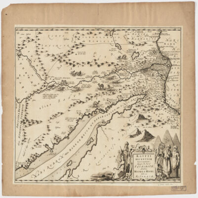
5. Ægypti recentior descriptioÆgyptis & Turcis Elchibith, Arabibus Mesre & Misri, Hebræis Mitsraim Date: Date Issued: 1659?] Language: LatinHebrewArabic Geographic region: Place of Production: ne, Netherlands, [AmstelodamiEgyptNile River Valley Extent: 1 map ; 39 x 50 cm.