51 maps from the Cairo 1:1000 series published by the Survey of Egypt between 1929 and 1986. \r\nFor more information go to the catalogue website using the link: https://lib.aucegypt.edu/search~S2/?searchtype=c&searcharg=G8304.C2&searchscope=2&sortdropdown=-&SORT=D&extended=1&SUBMIT=Search&searchlimits=&searchorigarg=cG8304.C2P1
dressée au Service géographique de l'armée.Covers also a portion of Algeria and Libya.Relief shown by shading and spot heights. Depth shown by isolines.In French with place names in Arabic and Latin in Latin script.Table of Contents: "Tunisie (800 000e) Flle Nord" -- "Tunisie (800 000e) Flle Sud".
dressée au Service géographique de l'armée.Covers also a portion of Algeria and Libya.Relief shown by shading and spot heights. Depth shown by isolines.In French with place names in Arabic and Latin in Latin script.Table of Contents: "Tunisie (800 000e) Flle Nord" -- "Tunisie (800 000e) Flle Sud".
dressée au Service géographique de l'armée.Covers also a portion of Algeria and Libya.Relief shown by shading and spot heights. Depth shown by isolines.In French with place names in Arabic and Latin in Latin script.Table of Contents: "Tunisie (800 000e) Flle Nord" -- "Tunisie (800 000e) Flle Sud".
Text in Arabic reads: "The first map for Egypt governorates was drawn by the French expedition cartographers at the beginning of the 13th century H. (1213-1216 H.), but the hardships and resistance they have faced during their work, in addition to their ignorance of the Arabic language misled them to put the Arabic names on the right locations. All that lead to various mistakes in the French map and the maps that copied from it until we produced this map.\r\nTherefore, Khedive Ismail of Egypt, ordered me “Mahmoud Bey al Falaky” to draw a new map with the needed corrections. As the needed cartographic tools were not available at the time, I resorted to the astronomical coordinates.\r\nThe map was finished in 1287 H. representing all the cultivation and urbanization that has been implemented upon the orders of the khedive on that year."\r\n\r\n\r\nLithography by F.A. Brockhaus, Leipzig.Scale: 1:200,000
par E. Andriveau ; gravé le trait et les montagnes par Gérin, les écritures par P. Rousset, les eaux par Mme Fontaine.Covers portions of Israel, Jordan, Syria and Lebanon.Relief shown by hachures. Depth shown by sounding and isolines.Insets: [Sinai] (Scale [ca. 1:2,600,000]) -- Golfe de Suez -- [Cross section of the Palestine from the source of the Jordan to the Red Sea] -- [Panoramic view of the mountains of Palestine] -- Jérusalem d'après le plan de G. Williams (Scale [ca. 1:80,000])."No. 18"."Atlas usuel No. 23"."Atlas universel No.36".Includes notes and index.In French with place names in Latin, Arabic and Hebrew in Latin script.Electronic reproduction. Cambridge, Mass. : Harvard Geospatial Library, 2009. Georeferenced image for use in a GIS.
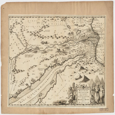
Covers Egypt and portions of Libya, Israel and Jordan, including the Red Sea and the Nile.Relief shown pictorially.Oriented with North to the right.Includes ill.Appears in: Nieuwen atlas ofte werelt-beschrijvinge vertoonende de voornaemste rijckenende landen des gheheelen aerdt-bodems; vermeerdert met veel schoone landt-kaerten, nieuwelijcks uptgegeven (...) / Ioannem Iansonium, 1657-87. Vol. 3, map No. 96.In Latin with place names in Hebrew and Arabic in Latin script.