Skip to search
Skip to main content
Skip to first result
Digital Library of the Middle East
Show facets
Hide facets
English
العربية
Contact us
Contact us
To contact us about any matter related to DLME, please use the form below.
Message
Your name
Ignore this text box. It is used to detect spammers. If you enter anything into this text box, your message will not be sent.
Your email
Cancel
Digital Library of the Middle East
Preserve. Access. Inspire.
Home
Explore
Contributors
About
Search in
Everything
Title
Creator / Contributor
Identifier
search for
Search
Home
Search results
Search
Search Constraints
Start Over
You searched for:
Type
Image:Maps
✖
Remove constraint Type: Image:Maps
Language
Arabic
✖
Remove constraint Language: Arabic
« Previous |
1
-
48
of
63
|
Next »
Sort
by Title
Relevance
Title
Creator
Date (old to new)
Date (new to old)
Number of results to display per page
48
per page
per page
12
per page
24
per page
48
per page
96
per page
View results as:
List
Gallery
Slideshow
Search Results
×
'Pocket No. 25: Enclosure to Part III of Volume I of the Persian Gulf Gazetteer: Chart showing the Pearl Banks along the Arabian Shore of the Persian Gulf between Ras Tanura and Debai'
1 of 63
'Kuwait'
2 of 63
'KUWAIT'
3 of 63
'ANNEXE B. SOUTH ARABIA ANGLO-TURKISH BOUNDARY.'
4 of 63
'ANNEXE B. SOUTH ARABIA ANGLO-TURKISH BOUNDARY. SHEET NO. 1'
5 of 63
'ANNEXE B. SOUTH ARABIA ANGLO-TURKISH BOUNDARY. SHEET NO. 2'
6 of 63
'ANNEXE B. SOUTH ARABIA ANGLO-TURKISH BOUNDARY. SHEET NO. 3'
7 of 63
'South Arabia, Anglo-Turkish Boundary: Sheet No. 1'
8 of 63
'South Arabia, Anglo-Turkish Boundary: Sheet No. 2'
9 of 63
'South Arabia, Anglo-Turkish Boundary: Sheet No. 3'
10 of 63
'South Arabia, Anglo-Turkish Boundary: Sheet No. 4'
11 of 63
'Map of Haushabi and Subaihi Border'
12 of 63
'Map of Subaihi Border'
13 of 63
‘Chart of the Gulf of Persia. Constructed from the Trigonometrical Surveys Made by Order of The Hon.ble the Court of Directors of the United English East India Company; by George Barnes Brucks, Commander H.C. Marine. 1830. Engraved by R. Bateman, 85 Long Acre’
14 of 63
‘Arabic Characters to Accompany and for Insertion in the Chart of the Persian Gulf’
15 of 63
Alexandria
16 of 63
Alexandria, Department of Survey and Mines
17 of 63
Banha
18 of 63
Cairo
19 of 63
Cairo
20 of 63
Cairo Abbasiya
21 of 63
Cairo Bulaq, Zamalek, Downtown
22 of 63
Cairo Dahab Island, Dar al-Salaam
23 of 63
Cairo Heliopolis
24 of 63
Cairo Heliopolis
25 of 63
Cairo Jazīrat Warrāq al Ḩaḑar
26 of 63
Cairo Zamalek, Agouza, Imbaba
27 of 63
Cairo, 1:500
28 of 63
Cairo, 1:1000
29 of 63
Carte de la Tunisie
30 of 63
Carte de la Tunisie
31 of 63
Carte de la Tunisie
32 of 63
El-Maadi
33 of 63
Khariṭat al-Wajh al-Baḥarī lil-aqālīm al-Miṣrīyah
34 of 63
Kharīṭat madīnat al-Iskandarīyah
35 of 63
Luxor
36 of 63
Map of the tropical lakes with the locations of the dams and waters reservoirs
37 of 63
Maps from "Fī Miṣr al-Islāmīyah"
38 of 63
Maps from "Tārīkh Miṣr al-siyāsī fī al-azminah al-ḥadīthah"
39 of 63
Maps from "Tārīkh al-barīd fī Miṣr"
40 of 63
Maps from "al-Qāhirah"
41 of 63
Maps from "al-Thawrah al-ʻUrābīyah wa-al-iḥtilāl al-Injilīzī"
42 of 63
Maps from "Ṣawt Miṣr"
43 of 63
Mediterranean Battle of Abu Kir, 1 August 1798
44 of 63
Nile main stream, between Halfa and Khartoum with the locations of the second and fourth water falls
45 of 63
Palestine ancienne & moderne d'après les sources les plus authentiques
46 of 63
Ramleh (El Raml)
47 of 63
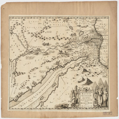
Ægypti recentior descriptioÆgyptis & Turcis Elchibith, Arabibus Mesre & Misri, Hebræis Mitsraim
48 of 63
« Previous
Next »
1
2