Distinctive Features:An outline map entitled 'Chart showing the Pearl Banks along Arabian Shore of the Persian Gulf between Ras Tanura and Dabai' issued as an enclosure to Part II of Volume I of the ‘Persian Gulf Gazetteer'. Shows the southern coast of the Persian Gulf between Ras Tanura and Dabai [Dubai] with the location of the pearl banks indicated. Each of the pearl banks is marked with a number.Bottom left-hand corner below neat line: ‘Reg. No. 1605 E., 14.-V.-225’.1 mapDimensions:361 x 585 mm, on sheet 457 x 683 mm
This maps, dawn in colour, indicates the territory of Kuwait, and its major settlements in English and Arabic.1 MapMaterials: Bromide hand coloured in watercolourDimensions: 410 x 340 mm
Map of Kuwait produced (according to a letter on folio 409 of IOR/L/PS/12/3811) by the Anglo-Persian Oil Company (APOC).The map shows main settlements (with place names in both English and Arabic), and gives some indication of relief. The boundaries of Kuwait are shown by means of a line of thick dashes and dots, and are explained in the letter on folio 409.1 mapMaterials: printed on paper.Dimensions: 320 x 400mm, on sheet 330 x 410mm.
This map is enclosed in a printed copy of the Anglo-Ottoman Convention of 1914. It depicts the line of demarcation of the boundary determined to separate the Yemen from the territory of the nine cantons of Aden (shown in blue). Also included is an enlarged inset map of the Shekh Sa'id [Ra’s Shaykh Sa‘īd] peninsula.The map's borders are lettered and numbered. Areas on the map are marked with Roman numerals and listed in a table of references. Another table provides a key to symbols and abbreviations. Place names and symbol and abbreviation references are printed in English and Arabic. As well as boundaries the map indicates hydrology, settlements, cultivation and roads. Relief is shown by contours and spot heights.This map is sheet four of four. Also included is an index to adjoining sheets and a note on the survey's sources.Small printed text near below the map states that it was surveyed by the Anglo-Turkish Boundary Commission, under Colonel Robert Alexander Wahab and Colonel Mustapha Remzi Bey, and printed at the Ordnance Survey Office, Southampton, 1914. The map also states the names of the British and Ottoman signatories of the Anglo-Ottoman Convention: E Grey [Edward Grey, Secretary of State for Foreign Affairs] and I Hakky [Ibrahim Hakki Pasha, Ottoman representative].1 map on 4 sheetsMaterials: Printed on paper.Dimensions: 935 x 621mm, on sheet 1081 x 689mm.
This map is enclosed in a printed copy of the Anglo-Ottoman Convention of 1914. It depicts the line of demarcation of the boundary determined to separate the Yemen from the territory of the nine cantons of Aden (shown in blue).The map's borders are lettered and numbered and are used to reference places in an accompanying table. Areas on the map are marked with Roman numerals and are listed in a second table of references. A third table provides a key to symbols and abbreviations. Place names and symbol and abbreviation references are printed in English and Arabic. The map also indicates hydrology, settlements, cultivation and roads. Relief is shown by contours and spot heights.This map is sheet one of four. Also included is an index to adjoining sheets and a note on the survey's sources.Small printed text near below the map states that it was surveyed by the Anglo-Turkish Boundary Commission, under Colonel Robert Alexander Wahab and Colonel Mustapha Remzi Bey, and printed at the Ordnance Survey Office, Southampton, 1914. The map also states the names of the British and Ottoman signatories of the Anglo-Ottoman Convention: E Grey [Edward Grey, Secretary of State for Foreign Affairs] and I Hakky [Ibrahim Hakki Pasha, Ottoman representative].1 map on 4 sheetsMaterials: Printed on paper.Dimensions: 485 x 865mm, on sheet 680 x 980mm.
This map is enclosed in a printed copy of the Anglo-Ottoman Convention of 1914. It depicts the line of demarcation of the boundary determined to separate the Yemen from the territory of the nine cantons of Aden (shown in blue).The map's borders are lettered and numbered and are used to reference places in an accompanying table. Areas on the map are marked with Roman numerals and are listed in a second table of references. A third table provides a key to symbols and abbreviations. Place names and symbol and abbreviation references are printed in English and Arabic. The map also indicates hydrology, settlements, cultivation and roads. Relief is shown by contours and spot heights.This map is sheet two of four. Also included is an index to adjoining sheets and a note on the survey's sources.Small printed text near below the map states that it was surveyed by the Anglo-Turkish Boundary Commission, under Colonel Robert Alexander Wahab and Colonel Mustapha Remzi Bey, and printed at the Ordnance Survey Office, Southampton, 1914. The map also states the names of the British and Ottoman signatories of the Anglo-Ottoman Convention: E Grey [Edward Grey, Secretary of State for Foreign Affairs] and I Hakky [Ibrahim Hakki Pasha, Ottoman representative].1 map on 4 sheetsMaterials: Printed on paper.Dimensions: 803 x 554mm, on sheet 989 x 670mm.
This map is enclosed in a printed copy of the Anglo-Ottoman Convention of 1914. It depicts the line of demarcation of the boundary determined to separate the Yemen from the territory of the nine cantons of Aden (shown in blue).The map's borders are lettered and numbered and are used to reference places in an accompanying table. Areas on the map are marked with Roman numerals and are listed in a second table of references. A third table provides a key to symbols and abbreviations. Place names and symbol and abbreviation references are printed in English and Arabic. The map also indicates hydrology, settlements, cultivation and roads. Relief is shown by contours and spot heights.This map is sheet three of four. Also included is an index to adjoining sheets and a note on the survey's sources.Small printed text near below the map states that it was surveyed by the Anglo-Turkish Boundary Commission, under Colonel Robert Alexander Wahab and Colonel Mustapha Remzi Bey, and heliozincographed at the Survey of India Offices, Calcutta. The map also states the names of the British and Ottoman signatories of the Anglo-Ottoman Convention: E Grey [Edward Grey, Secretary of State for Foreign Affairs] and I Hakky [Ibrahim Hakki Pasha, Ottoman representative].1 map on 4 sheetsMaterials: Printed on paper.Dimensions: 936 x 560mm, on sheet 1081 x 633mm.
A printed map of the border between the British Protectorate of Aden and the Ottoman Vilayet of Yemen. The map is one of four that fit together to show the border area in its entirety.The map was surveyed by the Anglo-Turkish Boundary Commission under Colonel R A Wahab and Colonel Mustapha Remzi Bey.The map has all place names listed in English and Arabic.1 folioDimensions: 700mm x 1,110mmMaterials: 1 paper folio
A printed map of the border between the British Protectorate of Aden and the Ottoman Vilayet of Yemen. The map is one of four that fit together to show the border area in its entirety.The map was surveyed by the Anglo-Turkish Boundary Commission under Colonel R A Wahab and Colonel Mustapha Remzi Bey.The map has all place names listed in English and Arabic.1 folioDimensions: 700mm x 1,110mmMaterials: 1 paper folio
A printed map of the border between the British Protectorate of Aden and the Ottoman Vilayet of Yemen. The map is one of four that fit together to show the border area in its entirety.The map was surveyed by the Anglo-Turkish Boundary Commission under Colonel R A Wahab and Colonel Mustapha Remzi Bey.The map has all place names listed in English and Arabic.1 folioDimensions: 700mm x 1,110mmMaterials: 1 paper folio
A printed map of the border between the British Protectorate of Aden and the Ottoman Vilayet of Yemen. The map is one of four that fit together to show the border area in its entirety.The map was surveyed by the Anglo-Turkish Boundary Commission under Colonel R A Wahab and Colonel Mustapha Remzi Bey.The map has all place names listed in English and Arabic.1 folioDimensions: 700mm x 1,110mmMaterials: 1 paper folio
A printed map of the Haushabi and Subaihi border regions of the British Protectorate of Aden. The map is signed by Colonel R A Wahab, the Commissioner of the Aden Boundary Commission. The map includes a list of place names in English and Arabic.1 folioDimensions: 680mm x 550mmMaterials: 1 paper folio that has been lined with cloth support at a later date.
A printed map of the Subaihi border region between the British Protectorate of Aden and the Ottoman Vilayet of Yemen.The place names on the map are listed in English and Arabic.1 folioDimensions: 1050mm x 840mmMaterials: 1 paper folio lined with a cloth support.
Imprint:Published by James Horsburgh, Hydrographer to the East India Company.Distinctive Features:Relief shown by hachures. Depth shown by soundings.Nautical chart of the Persian Gulf compiled from the surveys carried out by the Bombay Marine’s officers between 1820 and 1829, with place names inserted in both English and Arabic.Includes an engraved note on the survey with dates and names of the officers responsible for surveying respective parts of the coast.Contains dedication to the Court of Directors of the United East India Company from George Barnes Brucks.Inscriptions:On verso of the western portion of the map, in pencil, extensive annotations on discrepancies in latitude and longitude values.1 map on 2 sheetsDimensions:1460 x 1160 mm, on sheets 863 x 673 mm
Distinctive Features:Hand drawn table compiled by the East India Company Chart Office to accompany the Chart of the Persian Gulf with transliterated Arabic place names inserted in black ink.Inscriptions:On recto in the upper right-hand corner in an annotation in black ink: ‘Reced. Pr. Upton Castle 3 May 1825’On verso in the centre of the sheet is an annotation in pencil: ‘The names marked with + are not exactly spelt in this list as they are marked on the Charts & Plans of the same places’.1 itemMaterials:Pen and ink on paper with additions in pencilDimensions:sheet 302 x 484 mm
Three sheets of Alexandria from 1940 map published by the Department of Survey & Mines. Sections consist of Abu Qîr, El Muntazah, and Alexandria. Sheet numbers 95/525, 94/495, 95/510Scale: 1:25,000
Map of Cairo published by the Survey of Egypt. Revised in 1927, first edition in 1930. Sheet 81/630. Location labels are in Arabic, while reference is in both English and Arabic. Map contains markings and text in red, blue, and green which were added by an unknown person. The writing discusses canals and drainage proposals in the area.Scale: 1:25,000
51 maps from the Cairo 1:1000 series published by the Survey of Egypt between 1929 and 1986. \r\nFor more information go to the catalogue website using the link: https://lib.aucegypt.edu/search~S2/?searchtype=c&searcharg=G8304.C2&searchscope=2&sortdropdown=-&SORT=D&extended=1&SUBMIT=Search&searchlimits=&searchorigarg=cG8304.C2P1
dressée au Service géographique de l'armée.Covers also a portion of Algeria and Libya.Relief shown by shading and spot heights. Depth shown by isolines.In French with place names in Arabic and Latin in Latin script.Table of Contents: "Tunisie (800 000e) Flle Nord" -- "Tunisie (800 000e) Flle Sud".
dressée au Service géographique de l'armée.Covers also a portion of Algeria and Libya.Relief shown by shading and spot heights. Depth shown by isolines.In French with place names in Arabic and Latin in Latin script.Table of Contents: "Tunisie (800 000e) Flle Nord" -- "Tunisie (800 000e) Flle Sud".
dressée au Service géographique de l'armée.Covers also a portion of Algeria and Libya.Relief shown by shading and spot heights. Depth shown by isolines.In French with place names in Arabic and Latin in Latin script.Table of Contents: "Tunisie (800 000e) Flle Nord" -- "Tunisie (800 000e) Flle Sud".
Text in Arabic reads: "The first map for Egypt governorates was drawn by the French expedition cartographers at the beginning of the 13th century H. (1213-1216 H.), but the hardships and resistance they have faced during their work, in addition to their ignorance of the Arabic language misled them to put the Arabic names on the right locations. All that lead to various mistakes in the French map and the maps that copied from it until we produced this map.\r\nTherefore, Khedive Ismail of Egypt, ordered me “Mahmoud Bey al Falaky” to draw a new map with the needed corrections. As the needed cartographic tools were not available at the time, I resorted to the astronomical coordinates.\r\nThe map was finished in 1287 H. representing all the cultivation and urbanization that has been implemented upon the orders of the khedive on that year."\r\n\r\n\r\nLithography by F.A. Brockhaus, Leipzig.Scale: 1:200,000
par E. Andriveau ; gravé le trait et les montagnes par Gérin, les écritures par P. Rousset, les eaux par Mme Fontaine.Covers portions of Israel, Jordan, Syria and Lebanon.Relief shown by hachures. Depth shown by sounding and isolines.Insets: [Sinai] (Scale [ca. 1:2,600,000]) -- Golfe de Suez -- [Cross section of the Palestine from the source of the Jordan to the Red Sea] -- [Panoramic view of the mountains of Palestine] -- Jérusalem d'après le plan de G. Williams (Scale [ca. 1:80,000])."No. 18"."Atlas usuel No. 23"."Atlas universel No.36".Includes notes and index.In French with place names in Latin, Arabic and Hebrew in Latin script.Electronic reproduction. Cambridge, Mass. : Harvard Geospatial Library, 2009. Georeferenced image for use in a GIS.
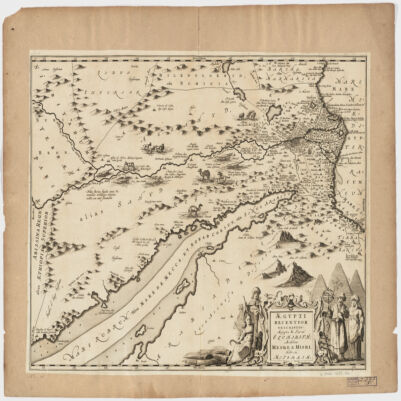
Covers Egypt and portions of Libya, Israel and Jordan, including the Red Sea and the Nile.Relief shown pictorially.Oriented with North to the right.Includes ill.Appears in: Nieuwen atlas ofte werelt-beschrijvinge vertoonende de voornaemste rijckenende landen des gheheelen aerdt-bodems; vermeerdert met veel schoone landt-kaerten, nieuwelijcks uptgegeven (...) / Ioannem Iansonium, 1657-87. Vol. 3, map No. 96.In Latin with place names in Hebrew and Arabic in Latin script.
Distinctive Features:Relief shown by hachures.Roads indicated by pecked lines. Shows Qatar and Bahrain.The Southern border of Qatar is indicated by a thick pecked line.Copy of the map enclosed to a letter on the question of the Southern limit of the Qatar Oil Concession sent by L. Lefroy at the Britannic House, London, to J.G. Laithwhite at the India Office, London, on 18 January 1935 (IOR/R/15/416, folio 4).Inscriptions:Toponyms are in English; Qatar and Dohah are also translated to Arabic.1 map sheetMaterials: printed on paperDimensions: 402 x 250 mm; on sheet 415 x 299 mm.Foliation: The map has been foliated in the top right hand corner with a pencil number enclosed in a circle.
Distinctive Features:Relief shown by hachures.Roads indicated by pecked lines. Shows Qatar and Bahrain.The Southern border of Qatar is indicated by a thick pecked line.Enclosed is a letter on the question of the Southern limit of the Qatar Oil Concession sent by L. Lefroy at the Britannic House, London, to J.G. Laithwhite at the India Office, London, on 18 January 1935 (IOR/R/15/416, folio 4).Inscriptions: Toponyms are in English; Qatar and Dohah [sic] are also translated to Arabic.1 map sheetMaterials: printed on paperDimensions: 402 x 250 mm; on sheet 415 x 299 mm.Foliation: The map has been foliated in the top right hand corner with a pencil number enclosed in a circle.
Distinctive features:Title deed plan dated 8th Safar, 1363, corresponding with 3rd February 1944.Shows plot of land situated at Umm al Hasam, Manamah which was exchanged for the land situated in Ghosaibia, Manamah in order to provide space for the Royal Navy base at Jufair.Labelled and coloured for reference with measurements reported.1 planMaterials:Pen and ink with wash on tracing clothDimensions:190 x 200 mm, on sheet 266 x 225 mm
Distinctive features:Title deed plan dated 6th Safar, 1363, corresponding with 1st February 1944.Shows plot of land situated at Ghosaibia, Manamah which was exchanged for the land situated in Umm al Hasam, Manamah in order to provide space for the Royal Navy base at Jufair.Labelled and coloured for reference with measurements reported.1 planMaterials:Pen and ink with wash on tracing clothDimensions:140 x 160 mm, on sheet 276 x 225 mm
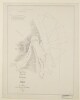
This sketch map is a south-north depiction of Gwadur [Gwadar] and the surrounding area, with place names and landmarks written in Arabic. Scale not given.1 mapMaterials: Manuscript; ink and pencil on paper.Dimensions: 303 x 665mm.
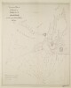
The map shows the locations of pearl banks along the east coast of the Persian Gulf between Kuwait and Ras Tanura. The map is a rough, hand-drawn sketch. The pearl banks are numbered from 1-58 which correspond to a numbered list (in Arabic) which appears on the sheet. Also given are the names of coastal features, towns, and islands. Accompanying the map (folios 12-13) is a second numbered list of pearl banks in the Gulf, most of which match that of the map. The map and lists were compiled by Major Stuart George Knox, Political Agent, Kuwait, 'with the assistance of nakhoda [nakhuda] Saleh of the Koweit [Kuwait] pearlers'.1 mapMaterials: Manuscript; ink on paperDimensions: 560 x 332mm
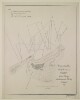
Distinctive Features:Depths shown by soundings.Hand drawn nautical chart of the shores of the Persian Gulf compiled from the survey carried out by the Bombay Marine’s officers in 1822 showing Amulgawein [Umm al-Quwain] with the location of fresh water wells marked.Place names given both in English and Arabic.Includes note on water levels and soundings with latitude and longitude of the town reported.Michael Houghton’s initials inserted in the bottom right hand-corner above the neat line.Oriented with south to the top.1 mapMaterials:Pen and ink on paperDimensions:633 x 810 mm, on sheet 660 x 835 mm
Distinctive Features:Depths shown by soundings.Hand drawn nautical chart of the shores of the Persian Gulf compiled from the survey carried out by the Bombay Marine’s officers in 1822 showing Debai [Dubai]. The town gates and ‘Sheeks house’ labelled with the location of date plantation and fresh water wells marked.Place names given both in English and Arabic.Includes notes on water levels and soundings with latitude and longitude of the ‘Western Tower’ reported.Oriented with west to the top.1 mapMaterials:Pen and ink with wash on paperDimensions:452 x 475 mm, on sheet 498 x 555 mm
Distinctive Features:Depths shown by soundings.Hand drawn nautical chart of the shores of the Persian Gulf compiled from the survey carried out by the Bombay Marine’s officers in 1822 showing Sharja [Sharjah, United Arab Emirates] with the location of fresh water wells marked.Place names given both in English and Arabic.Includes note on water levels and soundings with latitude and longitude of a ‘square tower’ reported.1 mapMaterials:Pen and ink on paperDimensions:455 x 570 mm, on sheet 497 x 618 mm
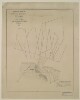
Distinctive Features:Depths shown by soundings.Hand drawn nautical chart of the shores of the Persian Gulf compiled from the survey carried out by the Bombay Marine’s officers in 1822 showing Aymaun [‘Ajmān] with the location of fresh water wells marked.Place name given both in English and Arabic.Includes note with remarks on latitude and longitude variations and water levels observation details.1 mapMaterials:Pen and ink on paperDimensions:401 x 490 mm, on sheet 475 x 569 mm
Imprint:‘Batliboi Litho Works, Bombay 8’.Distinctive Features:Pearl banks indicated by Arabic numerals, the names of topographic features including settlements, islands and pearl beds inserted in Arabic.In the lower right-hand corner of the sheet a descriptive note from the author, this starts and ends with prayers. It includes explanation to the surveying methods and reasons for creating the map, as well as the author’s approval and stamp with his name (Shaykh Mani’ ibn al-Shaykh Rashid al-Maktum), the date: 24 Jumada II 1359 AH, and a note ‘all right reserved’.Labels:Stamp in purple ink which states in Arabic that the map is not to be translated to any other language without author’s permission.1 mapDimensions:495 x 880 mm, on sheet 558 x 925 mm
Distinctive Features:Undated. Date of production derived from the accompanying document.A photographic copy of Arabic plan relating to the deed of purchase for the land designated for the Jufayr Naval Base, with the seal of Shaikh Ḥamad bin ‘Īsá Āl Khalīfah, and signed by Charles Dalrymple Belgrave and M Khalil. Location and extent of the land boundaries stated in a Register [al-tasjīl]: No. 388, 1353; Tapu [al-ṭabū]: No. 13/566, 1352 (folios 90-91). Another copy of this plan hold at IOR/R/15/2/216, f. 91B.1 mapMaterials:Photographic printDimensions:332 x 285 mm, on sheet 352 x 302 mm
Distinctive Features:Undated. Date of production derived from the accompanying document.A photographic copy of Arabic plan relating to the deed of purchase for the land designated for the Jufayr Naval Base, with the seal of Shaikh Ḥamad bin ‘Īsá Āl Khalīfah, and signed by Charles Dalrymple Belgrave and M Khalil. Location and extent of the land boundaries stated in a Register [al-tasjīl]: No. 388, 1353; Tapu [al-ṭabū]: No. 13/566, 1352 (folios 90-91). Another copy of this plan hold at IOR/R/15/2/216, f. 91C.1 mapMaterials:Photographic printDimensions:332 x 285 mm, on sheet 350 x 302 mm
Distinctive Features:Undated. Date of production derived from the accompanying document.A photographic copy of Arabic plan relating to the deed of purchase for the land designated for the Jufayr Naval Base, with the seal of Shaikh Ḥamad bin ‘Īsá Āl Khalīfah, and signed by Charles Dalrymple Belgrave and M Khalil. Location and extent of the land boundaries stated in a Register: No. 407, 1353; Tapu: No. 511, 1352 (folio 91).1 mapMaterials:Photographic printDimensions:328 x 231 mm, on sheet 348 x 247 mm
Distinctive Features:General chart of the Persian Gulf published in 1832 by James Horsburgh and engraved by Richard Bateman. The western sheet only, lacking the title and publisher’s details.Relief in hachures. Depth shown by soundings.Nautical chart of the Persian Gulf compiled from the surveys carried out by the Bombay Marine’s officers between 1820 and 1829, with place names inserted in both English and Arabic.Gives detailed information on the coastline and waters of the Persian Gulf, including documenting pearl banks, rock banks, shoals and shallows. A memorandum is included in the bottom right corner of the map giving the surveys which it is based upon:'The coast from Ras Moosenden [Musandam] to Abothubbee [Abu Dhabi] was Surveyed by Lieuts J M Guy, G B Brucks and R Cogan in 1821 and 1822; from Abothubbee to Cape, or Ras Reccan, by Lieuts J M Guy and G B Brucks in 1823 and 1824; from the latter point to Core Abdullah by Lieuts Guy, Brucks and W E Rogers, in 1824 and 1825,- from Ras Tuloop to Bushire, in 1825-26, and the remainder of Coast, Islands etc by Lieuts G B Brucks and S B Haines from 1826 to 1829.'The map has been annotated with a red line to show the direction which Lewis Pelly travelled on leaving Koyt [Kuwait] for Riyadh and the direction he returned from to Bahrein [Bahrain] as well as the route that the H.M.S. "Berenice" BM took from Koyt to Bahrein to meet Lewis Pelly on his return. The top right hand corner of the map sheet contains a pencil annotation giving the longitude and latitude coordinates for Riyath [Riyadh]. Lewis Pelly departed from Kuwait in February 1865 and reached Bahrain in March 1865 and the annotations were made to the map sometime afterwards.1 mapDimensions:728 x 522 mm; on sheet 770 x 610 mmCondition:There are some small tears in the centre of the map where it has been folded and a stain mark along the bottom half of the left hand border of the map.Foliation:The map has been foliated in the top right hand corner of the folio with a pencil number enclosed in a circle.