1. A generall mapp of the Coast of Barbarie, where in are the Kingdoms, and Estates of Morocco, Fez, Algiers, Tunis and Tripolialso the Kingdoms, Estates and Deserts of Barca, Egipt, Libya, Biledulgerid, Segelmesse and Darha: with the circumjacent counteries Creator: Sanson, Nicolas, 1600-1667 (المنشئ) Date: Date Issued: 1667?] Language: EnglishFrench Geographic region: Place of Production: enk, England, [LondonMoroccoTunisiaAlgeriaMauritania Extent: 1 map on 2 sheets ; 28 x 106 cm, sheets 35 x 57 cm and 35 x 59 cm.
2. A generall mapp of the Coast of Barbarie, where in are the Kingdoms, and Estates of Morocco, Fez, Algiers, Tunis and Tripolialso the Kingdoms, Estates and Deserts of Barca, Egipt, Libya, Biledulgerid, Segelmesse and Darha: with the circumjacent counteries Creator: Sanson, Nicolas, 1600-1667 (المنشئ) Date: Date Issued: 1667?] Language: EnglishFrench Geographic region: Place of Production: enk, England, [LondonMoroccoTunisiaAlgeriaMauritania Extent: 1 map on 2 sheets ; 28 x 106 cm, sheets 35 x 57 cm and 35 x 59 cm.
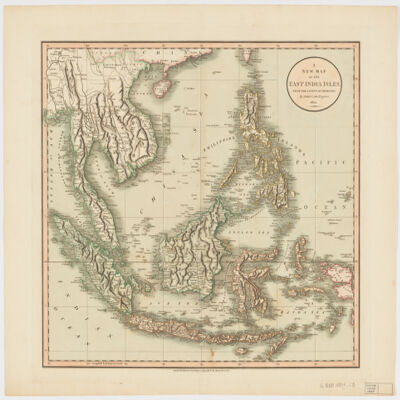
3. A new map of the East India Islesfrom the latest authorities Creator: Cary, John, approximately 1754-1835 (المنشئ) Date: Date Issued: Dec. 21, 1801 Language: English Geographic region: Place of Production: enk, England, LondonSoutheast AsiaEast IndiesIndonesiaMalay PeninsulaIndochinaPhilippines Extent: 1 map : hand col. ; 44 x 50 cm.
4. Atlas of Egypt... presented to the international geographic congress at Cambridge... Date: 1928 Language: English
5. Bône (Algeria) Contributor: Great Britain War Office. General Staff. Geographical Section. Date: 1942 Language: English
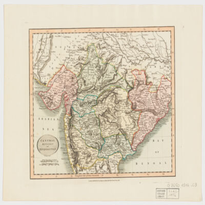
6. Central division of Hindoostan Creator: Cary, John, approximately 1754-1835 (المنشئ) Date: Date Issued: June 1, 1816 Language: English Geographic region: Place of Production: enk, England, LondonIndia Extent: 1 map : hand col. ; 22 x 27 cm.
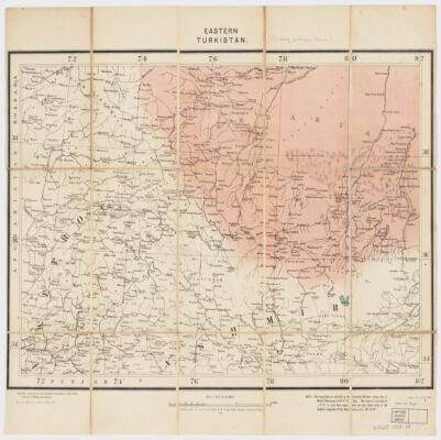
8. Eastern Turkistan Creator: Survey of India (المنشئ) Date: Date Issued: Feb. 1908 Language: English Geographic region: Place of Production: ii, India, [Calcutta]Asia, CentralXinjiang Uygur Zizhiqu (China)Northern Areas (Pakistan)North-West Frontier Province (Pakistan)Jammu and Kashmir (India) Extent: 1 map : col. ; 34 x 48 cm.
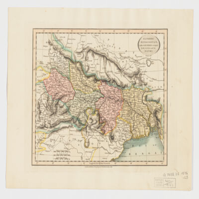
9. Gangetic Hindoostan or the countries occupied by the Ganges and the branches Creator: Cary, John, approximately 1754-1835 (المنشئ) Date: Date Issued: June 1, 1816 Language: English Geographic region: Place of Production: enk, England, LondonIndia, NortheasternBangladeshNepal Extent: 1 map : hand col. ; 22 x 27 cm.
10. L'Etbaye [Nubie orientale] pays habité par les arabes Bicharieh ; géographie, ethnologie, mines d'or / par Linant de Bellefonds Bey [Louis-Maurice-Adolphe] Creator: Linant de Bellefonds, Louis Maurice Adolphe (1799-1883)A Date: 1868 Language: English
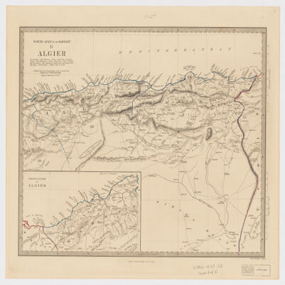
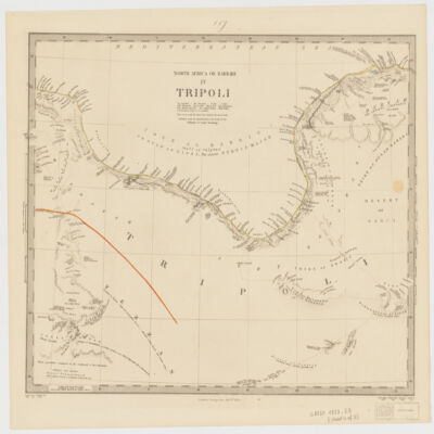
11. North Africa or Barbary Creator: Society for the Diffusion of Useful Knowledge (Great Britain) (المنشئ) Date: Date Issued: Jan. 1st, 1853 Language: English Geographic region: Place of Production: uk, , LondonAfrica, North Extent: 5 maps : col. ; 30 x 37 cm. each, sheets 37 x 44 cm.
12. North Africa or Barbary Creator: Society for the Diffusion of Useful Knowledge (Great Britain) (المنشئ) Date: Date Issued: Jan. 1st, 1853 Language: English Geographic region: Place of Production: uk, , LondonAfrica, North Extent: 5 maps : col. ; 30 x 37 cm. each, sheets 37 x 44 cm.