1. 'ASIA. PERSIAN GULF. COMPILED BY COMMR. C.G. CONSTABLE AND LIEUT. A.W. STIFFE, I.N. 1860' Date: 1899/1900 Language: English Extent: 1 map
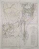
2. ‘THE TERRITORIES OF HIS HIGHNESS THE KHAN OF KELAT, OR BALUCHISTAN WITH THE ADJACENT PORTIONS OF SIND, THE PUNJAB, AFGHANISTAN AND PERSIA. 1876’ Contributor: Sir Henry Edward Landor Thuillier (surveyor) Date: 1877/1877 Language: English Geographic region: Mekran CoastBaluchistan Extent: 1 map on 2 sheets
4. ‘Winds and Currents in the PERSIAN GULF. BY Lieutenant Fergusson I.N.F.R.A.S. Draughtsman to the Indian Navy. Engraved by J.&C. Walker’ Contributor: J & C Walker, engravers (artist)John Walker (publisher)E.F.T. Fergusson (surveyor) Date: 1856/1856 Language: English Geographic region: Persian Gulf Extent: 12 maps
7. ‘Route through Persia on horse back’ Contributor: Survey of India (author) Date: 1888/1888 Language: English Extent: 1 map
8. ‘Persia compiled principally from original authorities by Captain (Local Major) O.B.C.ST. John, (Royal Engineers) by order of H.M. Secretary of State for India’ Contributor: Edward Stanford and Co, publishers and stationers (surveyor)Oliver Beauchamp Coventry St John (surveyor) Date: 1876/1876 Language: English Geographic region: Persia Extent: 1 map on 12 sheets
9. 'Persia, Afghanistan and Beluchistan [Baluchistan]' Date: 1891/1891 Language: English Extent: 1 map
11. ‘Beluchistan comprising Mekran and the Perso-Beluch Boundary.’ Contributor: Assistant Political Agent, Mekran Coast (author) Date: 1874/1874 Language: English Extent: 1 map
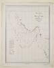
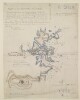
12. ‘Part of the Ruweïs at Jebál’ Contributor: C.G. Constable (surveyor) Date: 1862/1862 Language: English Geographic region: Masandam Peninsula Extent: 1 map sheet