Imprint:Berlin, published by Dietrich Reimer and engraved by Heinrich Mahlmann.Edition statement:Third edition; compiled and prepared by Dr. Heinrich Kiepert.5 maps
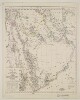
Distinctive Features:Relief shown by hachures and spot heights.Title continues: ‘Zu C. Ritter’s Erdkunde, Buch III, West-Asien, Theil XII. Bearbeitet von H. Kiepert, herausgegeben von C. Ritter. Berlin, 1852 Verlag von Dietrich Reimer’.Map of Hedjaz [Hejaz] province showing various routes including the Hajj pilgrimage, Carsten Niebuhr exploration journey, and J.G. Hulton and Charles J. Cruttenden expedition of 1836.In the bottom right-hand corner there is a table of reference listing Arabic geographic terms with German equivalents and abbreviations.Includes two insets:• plan of Mecca entitled ‘Mekka nach Burckhardt’ drawn to scale 1:30,000 with districts numbered and listed in a table of reference; • map of peninsula and the port of Aden entitled ‘Halbinsel und Hafen von Aden’ drawn to scale 1:200,000 with depths shown by contours.1 mapDimensions:491 x 349 mm, on sheet 584 x 476 mm
Distinctive Features:Relief shown by hachures.Title continues: ‘Zu C. Ritter’s Erdkunde, Buch III, West-Asien, Theil XII, XIII; bearbeitet von H. Kiepert, herausgegeben von C. Ritter. Berlin, 1852 Verlag von D. Reimer’.General map of Arabian Peninsula based on Carl Ritter’s ‘Die Erdkunde im Verhältnis zur Natur und zur Geschichte des Menschen’ [Geography in relationship to nature and to the history of humanity] showing various routes across the region including the Hajj pilgrimage, Captain George Forster Sadlier’s expedition of 1819 and George August Wallin‘s journey of 1848. Provinces and regions labelled with boundary coloured for reference.Includes inset map entitled ‘Oman’ showing Maskat [Muscat] with routes traversed by Pierre-Martin-Rémi Aucher-Eloy and James Raymond Wellsted marked. In the bottom right-hand corner there is a table of reference listing Arabic geographic terms with German equivalents and abbreviations.1 mapDimensions:353 x 475 mm, on sheet 742 x 580 mm
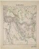
Distinctive Features:Relief shown by hachures.Title continues: ‘Zu C. Ritter’s Erdkunde, Buch III, West-Asien, Theil VIII, IX. Bearbeitet von H. Kiepert, herausgegeben von C. Ritter. Berlin, 1852 Verlag von D. Reimer’.Map of Iran showing territorial extent of the Ottoman, the Russian and the British sphere of influence in the region with borders outlined in colour and explained in a key in the bottom left-hand corner below title. Also shows the boundaries between provinces and various routes across the region.1 mapDimensions:462 x 490 mm, on sheet 478 x 584 mm
Pencil and ink sketch map of the island of Abu Mussa [Abū Mūsá]. The island’s coastline is marked in blue pencil. A number of features on the island are marked and annotated in German, including: an Arabic flag; the locations of two mines; an anchorage and loading point; heaps of red oxide. The map was possibly used in conjunction with a letter, from Shaikh Segger bin Kalet [Ṣaqr bin Khālid Āl Qāsimī] to Hage Hassan bin Ali Somey [Haji Hassan bin Ali Samaiyeh] (translation in the enclosing volume, folios 177-178) containing instructions for the collection of red oxide from Abu Mussa by the steamer
Louise.1 mapDimensions:200 x 285 mm.Materials:Pencil and pen on paper.
Distinctive Features:Title continues: ‘von einem Zögling der türkischen Ingenieurschule in Assuan in Romfode, in Handschrift mitgetheilt durch Prof. Ehrenberg zur Erläuterung der Erdkunde von Arabien. Band XII der Allg. E. p. 1027 u. f.’Relief shown by hachures.Includes inset with illustrations of rock inscriptions found on the coast of Hedjas with references to C. Ritter's ‘Erdkunde’.1 map sheetDimensions:420 x 475 mm, on sheet 600 x 690 mm
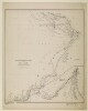
Distinctive Features:Relief shown by hachures.Shows routes of various expeditions with a table of explorers and dates of their journeys listed at left centre of sheet at IOR/X/2942/5/2.Includes inset: ‘Plan von Aden und des umliegenden Landes’ with soundings recorded and note: ‘nach den Parlaments Reports Indian Papers respecting Aden 1837 & 1838 & Foster Sketch of Cap Aden in Bombay Geographical Society Proceedings May 1839’.1 map sheetDimensions:525 x 500 mm, on sheet 690 x 604 mm
Distinctive Features:Relief shown by hachures.Shows routes of various expeditions with a list of explorers and dates of their journeys at left centre.Includes two insets: ‘Socotara’ and ‘KARTE DES Landstrichs zwischen Dsjidda und Tayf in HEDSCHAS ARABIEN’.1 map sheetDimensions:550 x 465 mm, on sheet 690 x 604 mm
Distinctive Features:Title continues: 'vornämlich nach Wellsted, ferner nach Whitelock, Cruttendon, Niebuhr, Haines Aucher Eloy, zu C. Ritters Erdkunde von Carl Zimmermann. Berlin 1846. Zum Arabischen Heft des Atlas von Vorder-Asien gehörig'.Coloured for reference.Includes inset map of Oman.The coast between Abu Dhabi and Dubai is labelled ‘Piraten Küste’; shows pearl banks to the west of Abu Dhabi bay.1 map sheetDimensions:600 x 570 mm, on sheet 687 x 604 mm
Imprint:Berlin, Published by Dietrich Reimer.Edition statement:Second edition, revised and expanded.Distinctive Features:From H. Kiepert’s ‘Neuer Handatlas’, map no. 28 engraved by J. Sulzer and printed by F. Barth.Relief shown by hachures.Boundaries of the Ottoman and Russian empires, British colonies in India and the extents of the Imam of Maskat territory outlined in colour with a key at bottom centre.Includes list of topographic terms in Turkish, Arabic and Persian.1 map sheetDimensions:403 x 534 mm, on sheet 505 x 614 mm
Imprint:Berlin, Published by Dietrich Reimer. Lithographed by Ansalt von L. Kraatz.Distinctive Features:Below title: ‘Buch III, West-Asien, Theil XII u. XIII bearbeitet von H. Kiepert neue berichtigte Ausgabe, die Ortographie revidirt von Th. Nöldeke, mit Nachträgen aus den neusten Berichten von Guarmani und Palgrave’.Relief shown by hachures.Includes an inset map: ‘Südliches Oman’ in the top right-hand corner.Includes a table of Arabian words with German equivalent terms in the bottom left.Sultanates and provinces outlined in colour with a key in the bottom right-hand corner.1 map sheetDimensions:380 x 490 mm
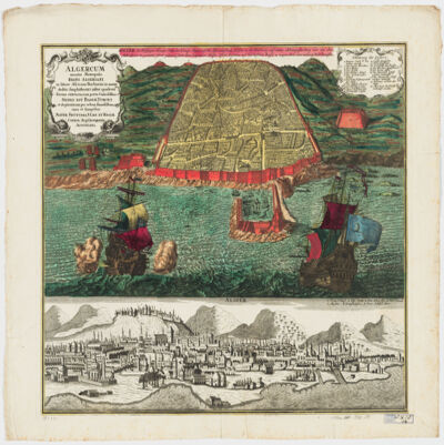
cura et sumptibus Matth. Seutteri.Birds-eye view.Appears in: Atlas novus sive tabulæ geographicæ totius orbis faciem, partes, imperia, regna et provincias exhibentes / exactissima cura iuxta recentissimas observation Matthaeo Seutter, [1745?]. Vol.1, map No. 137.Includes a close-up view of Algiers and index.In German with a title in Latin.Electronic reproduction. Cambridge, Mass. : Harvard College Library Digital Imaging Group, 2009. (Open Collections Program at Harvard University. Islamic Heritage Project). Copy digitized: Map Coll (Pusey) : MAP-LC G8244.A6 A3 1730 .S4.
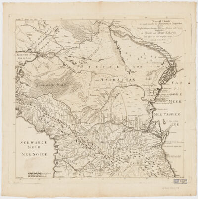
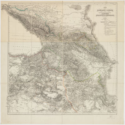
Charten, Reisen und astronomischen Orstbestimugen gezeichnet von I. C. M. Reinecke.Covers Azerbaijan, Georgia and portions of Armenia and the Russian Federation.Relief shown by hachures.Colored in outline.Includes note.Electronic reproduction. Cambridge, Mass. : Harvard Geospatial Library, 2009. Georeferenced image for use in a GIS.Electronic reproduction. Cambridge, Mass. : Harvard College Library Digital Imaging Group, 2009. (Open Collections Program at Harvard University. Islamic Heritage Project). Copy digitized: Map Coll (Pusey) MAP-LC G7120 1802 .R4.
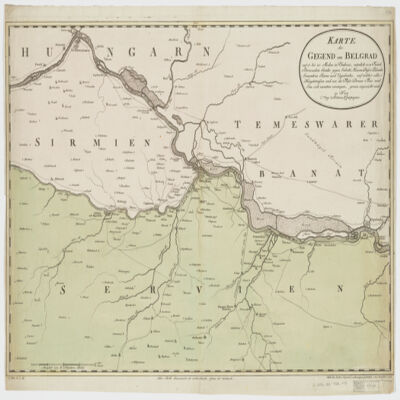
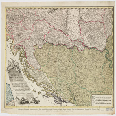
nach den militœrischen Handkarten des Prinzen Eugen der Grafen Khevenhüller, Marsigli und Pallavicini geographisch aufgetragen, und nach den zuverloessigsten Nachrichten, und Reisebeschreibungen berichtiget im Jahre 1788 von Herrn Maximilian Schimek ; J. Alberti Sculp. ; F. Müller Scrip.Shows locations and dates of battles.Covers Serbia, Albania, Bosnia, Croatia, Dalmatia and portions of Macedonia and Hungary.Relief shown pictorially.Prime meridian: Ferro.North oriented toward the left.Includes ill.
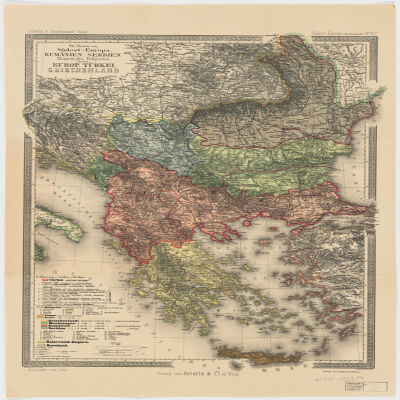
entworfen von C. Vogel ; bearbeitet von B. Domann ; gestochen von Kern, Kühn u. Weiler.Covers Bosnia und Herzegovina, Croatia, Montenegro, Greece, Serbia, Romania, Bulgaria, Macedonia and portions of Turkey.North oriented toward the right.Relief shown by hachures. Depths shown by bathymetry."No. 52" and "Stielers Hand-Atlas No. 54".Includes index.Insets: Constantinopel (Scale 1:150,000) -- Athens und Piraeus (Scale 1:150,000) -- Das Nördliche Rümanien im Anschluss and die Hauptkarte (Scale 1:1,500,000) -- Strasse der Dardanellen (Scale 1:150,000) -- Der Bosporus (Scale 1:150,000).Originally issued on 4 sheets.Electronic reproduction. Cambridge, Mass. : Harvard Geospatial Library, 2011. Georeferenced image for use in a GIS.
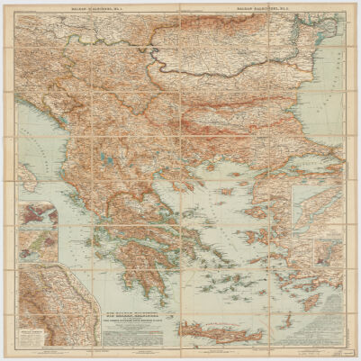
Redigiert v. Dr. K. Peucker ; Rudolph Maschek sculps ; Kartogr. Anst. v. Th. Bannwarth.Covers Romania, Bosnia and Hercegovina, Montenegro, Bulgaria, Macedonia, Albania, Greece, Cyprus and portions of Russia, Hungary, Croatia and Italy.Relief shown by hachures and spot heights. Depth shown by hachures.From: Scheda & Steinhauser Atlas. Sudost-Europa (Balkanländer) No. XV.Prime meridian: Greenwich and Ferro.Electronic reproduction. Cambridge, Mass. : Harvard College Library Digital Imaging Group, 2009. (Open Collections Program at Harvard University. Islamic Heritage Project). Copy digitized: Map Coll (Pusey) : MAP-LC G6800 1903 .P4.Electronic reproduction. Cambridge, Mass. : Harvard Geospatial Library, 2011. Georeferenced image for use in a GIS.
Nach Russischen und and Handschriften entworsen Strasburg bey Joh. Georg Treuttel ; I. P. Kremer delin ; B. F. Leizelt sc.Relief shown by hachures and pictorially.Prime meridian: Ferro.Includes ill.Map in German and French.Electronic reproduction. Cambridge, Mass. : Harvard College Library Digital Imaging Group, 2009. (Open Collections Program at Harvard University. Islamic Heritage Project). Copy digitized: Map Coll (Pusey) : MAP-LC G7060 1765 .T7.Electronic reproduction. Cambridge, Mass. : Harvard Geospatial Library, 2009. Georeferenced image for use in a GIS.
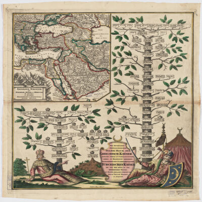
Covers Libya, Egypt, Sudan, the Arabian Peninsula, Lebanon, Syria, Iraq, Iran, the Balkan Peninsula, Turkey, Greece, Armenia, Azerbaijan and portions of Ethiopia and Russia.Relief shown by hachures and pictorially.Colored in outline.Inset: Neu Inventiert. Genealogischer Stamm-Baum Der Griechisch. Kaÿser Welche Theils Zu Constantinopel Theils Zu Trapezunt Residiret : desgleichen ein StammBaum Der Türckischen Kaÿser Bis Auf Den Heüt Zu Tag Regierenden Sultan / ins Kupfer gebracht u. verlegt von Matth. Seütter.Includes ill.In German and Latin.Electronic reproduction. Cambridge, Mass. : Harvard College Library Digital Imaging Group, 2009. (Open Collections Program at Harvard University. Islamic Heritage Project). Copy digitized: XXXXX Library: [call no.].
bearbeitet und gezeichnet von H. Kiepert.Relief shown by hachures and spot heights.Prime meridian Greenwich and Ferro.Colored in outline.Electronic reproduction. Cambridge, Mass. : Harvard College Library Digital Imaging Group, 2009. (Open Collections Program at Harvard University. Islamic Heritage Project). Copy digitized: Map Coll (Pusey) : MAP-LC G7120 1854 .K5.Electronic reproduction. Cambridge, Mass. : Harvard Geospatial Library, 2009. Georeferenced image for use in a GIS.
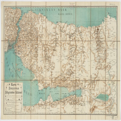
nach älteren Quellen (v. Moltke, Heinrich Kiepert, Brit. Admiralitätskarten, v. d. Goltz, v. Diest u.a.) und eigenen Aufnahmen im Jahre 1900 gezeichnet von Rudolf Fitzner ; Hof. Stdr. v. J. G. Tiedmann Nachf.Relief shown by hachures. Depths shown by contours.Includes index.Electronic reproduction. Cambridge, Mass. : Harvard College Library Digital Imaging Group, 2009. (Open Collections Program at Harvard University. Islamic Heritage Project). Copy digitized: Map Coll (Pusey) : MAP-LC G7433.I8 1900 .F5.Electronic reproduction. Cambridge, Mass. : Harvard Geospatial Library, 2014. Georeferenced image for use in a GIS.
Gestochen von F. Müller.Covers also portions of Albania, Macedonia, Bulgaria, Hungary, Romania, Croatia and Bosnia and Hercegovina.Relief shown pictorially.Includes ill.
nach den besten Originalzeichnungen Charten und Beschreibungen entworfen von Herrn Carl Schütz ; gestochen von C. Schütz und F. Müller.Covers Bosnia and Hercegovina, Slovenia, Croatia, Serbia and portions of Italy, Hungary, Bulgaria, Albania and Macedonia.Relief shown pictorially.Includes ill."C. Priv. S.C.M.""Erklærung der Illumination - Roth ist oesterreichisch, Grün türkisch , Gelb venetiatisch, Violet gehert der Republik Ragusa, Blau einen Theil des Kirchenstaats, und Orangefarb dem Koenig von Naepel."Electronic reproduction. Cambridge, Mass. : Harvard College Library Digital Imaging Group, 2009. (Open Collections Program at Harvard University. Islamic Heritage Project). Copy digitized: XXXXX Library: [call no.].