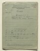
Map of Iran and its neighbours, indicating the extent of an oil concession granted to the Amiranian Oil Company. The map, with accompanying key, indicates: the Iranian frontier, the Amiranian Oil Company’s concession line; the names of countries and major settlements, given in French and Persian.The map, which has been taken from an unspecified Iranian newspaper, is referred to in (and was enclosed with) a letter dated 23 January 1937, sent by Horace James Samuel, HM’s Envoy Extraordinary and Minister Plenipotentiary at Tehran, to the Secretary of State for Foreign Affairs, Robert Anthony Eden. A copy of the letter precedes the map, along with a copy of the French text of an Iranian Government bill, granting oil concessions to US interests, including the Amiranian Oil Company (ff 32-40).1 mapMaterials:printed on paper.Dimensions:170 x 235 mm, affixed to sheet 200 x 330 mm.
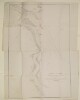
Imprint:Lithographed in the Office of the Chief Engineer of P.W. by H Essoobyee, and F de Jesus, Bombay, 7 March 1857.Distinctive Features:Below title the note: 'by Captain Felix Jones, Resident Persian Gulf, and Captain M. Green, Sind Horse, constructed while reconnoitring the Enemy's position at Mahomerah [Khorramshahr] in Company with Commander Ethersey and Captain J.W. Young. J.N. in February 1857’.Shows the course of the Hugh Lindsay by blue line.The place names are given in English and Persian.1 mapDimensions:1130 x 425 mm; on sheet 1180 x 524 mm or smaller.Foliation: The map sheet has been foliated in the top right hand corner of the folio with a pencil number enclosed in a circle.
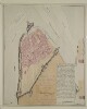
Inscriptions:Signed by Felix Jones, British Political Resident in the Gulf of Persia, and Political Agent to the Persian Expeditionary Forces.1 plan sheetMaterials:Pen and ink with wash on paperDimensions:446 x 560 mm, on sheet 466 x 580 mm
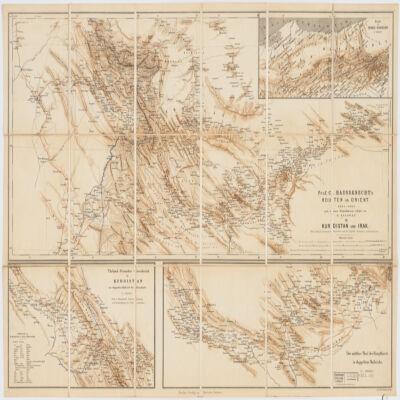
nach dessen Originalskizzen redigirt von H. Kiepert.Covers portions of Turkey, Iraq and Iran.Relief shown by shading.Prime meridian: Greenwich and Paris.Inset: Route in Nord-Persien (Scale 1:600,000).Ancillary maps: Türkish-Persischer Grenzbezirk in Kurdistan im doppelten Maβstab der Hauptkarte (Scale 1:400,000), Der mittlere Theil der Hauptkarte im doppeltem Maβstabe (Scale 1:400,000)."Druck v. Fr. Schwabe, Berlin".Includes lexicon German-Turkish-Persian.In German with place names in Turkish and Persian.Electronic reproduction. Cambridge, Mass. : Harvard College Library Digital Imaging Group, 2009. (Open Collections Program at Harvard University. Islamic Heritage Project). Copy digitized: XXXXX Library: [call no.].