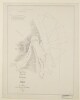
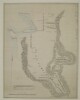
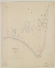
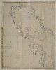
Distinctive Features:Hand-drawn map of tribal territories around Ras al Khaima with ports and valleys labelled, and routes indicated by pecked line. Muscat limits shown by hatched markings.Below map typed explanatory notes with references to the slave traffic, signed by Bertram S. Thomas and dated ‘16-11-26’.1 mapMaterials:Pen and ink on paper with typed textDimensions:315 x 202 mm
Distinctive Features:Hand drawn rough map of the central part of the Arabian Peninsula showing the approximate location of settlements in blue with Ad-Dahna Desert represented by red lines. Place names given in both English and Arabic inserted in pencil. Map is divided by a central compass rose orienting west to the top with 'quadrantal points' at 45 degrees to the four cardinal directions.1 mapMaterials:Pen and ink on paper with additions in pencil and crayonDimensions:500 x 400 mmWatermark:The paper contains the watermark ‘T H Saunders, 1860'.
Distinctive Features:Hand drawn rough sketch map of the area southwest of Safwan in Iraq, enclosed with a report of Kuwait-Iraq Frontier Incidents dated 29th September 1936 (folios 74-85). Shows the location of camps with number of tents and dates reported. Includes references to cases of smuggling which are described in the report.Another copy of the map can be found on folio 120.1 mapMaterials:Pen and ink on tracing paperDimensions:330 x 205 mm
Distinctive Features:Hand drawn rough sketch map of the area southwest of Safwan in Iraq, enclosed with a report of Kuwait-Iraq Frontier Incidents dated 29th September 1936 (folios 108-119). Shows the location of camps with number of tents and dates reported. Includes references to cases of smuggling which are described in the report.Another copy of the map can be found on folio 86.1 mapMaterials:Pen and ink on tracing paperDimensions:330 x 201 mm
Distinctive Features:Hand drawn nautical chart of the entrance of the Persian Gulf compiled from the survey carried out by the Bombay Marine’s officers in 1821. Shows positions of the islands off the shore of the Musandam Peninsula with a network of lines based on survey’s control points inserted on the map.Includes a descriptive note with remarks on survey execution in the centre right of the sheet.1 mapMaterials:Pen and ink on paperDimensions:637 x 492 mm, on sheet 745 x 550 mm
Distinctive Features:Depths shown by soundings.Hand drawn nautical chart of the shores of the Persian Gulf compiled from the survey carried out by the Bombay Marine’s officers in 1822 showing Amulgawein [Umm al-Quwain] with the location of fresh water wells marked.Place names given both in English and Arabic.Includes note on water levels and soundings with latitude and longitude of the town reported.Michael Houghton’s initials inserted in the bottom right hand-corner above the neat line.Oriented with south to the top.1 mapMaterials:Pen and ink on paperDimensions:633 x 810 mm, on sheet 660 x 835 mm
Distinctive Features:Depths shown by soundings.Hand drawn nautical chart of the shores of the Persian Gulf compiled from the survey carried out by the Bombay Marine’s officers in 1822 showing Debai [Dubai]. The town gates and ‘Sheeks house’ labelled with the location of date plantation and fresh water wells marked.Place names given both in English and Arabic.Includes notes on water levels and soundings with latitude and longitude of the ‘Western Tower’ reported.Oriented with west to the top.1 mapMaterials:Pen and ink with wash on paperDimensions:452 x 475 mm, on sheet 498 x 555 mm
Distinctive Features:Depths shown by soundings.Hand drawn nautical chart of the shores of the Persian Gulf compiled from the survey carried out by the Bombay Marine’s officers in 1822 showing Sharja [Sharjah, United Arab Emirates] with the location of fresh water wells marked.Place names given both in English and Arabic.Includes note on water levels and soundings with latitude and longitude of a ‘square tower’ reported.1 mapMaterials:Pen and ink on paperDimensions:455 x 570 mm, on sheet 497 x 618 mm
Distinctive Features:Depths shown by soundings.Hand drawn nautical chart of the shores of the Persian Gulf compiled from the survey carried out by the Bombay Marine’s officers in 1822 showing Aymaun [‘Ajmān] with the location of fresh water wells marked.Place name given both in English and Arabic.Includes note with remarks on latitude and longitude variations and water levels observation details.1 mapMaterials:Pen and ink on paperDimensions:401 x 490 mm, on sheet 475 x 569 mm
The map, which is drawn with black and red ink, indicates: the boundary between Afghanistan and the Chagai district of Baluchistan [in present-day Pakistan] as a solid red line; the North Western Railway as a dashed red line; hydrology; roads.1 mapDimensions:300 x 430 mm.Materials:ink on parchment.
A hand-drawn map of the Persian Gulf showing the islands of Farsi, Arabi, Harqus and Qran. The map shows place names but has little other detail.1 mapMaterials: drawn with ink on paperDimensions: 208mm x 340mm
A printed map of the border area of the British Protectorate of Aden.The map is signed by Colonel R A Wahab, Commissioner of the Aden Boundary Commission and was sent as an accompaniment to letter no. 49 sent from Colonel Wahab to the Government of India on 16 May 1902 (folio 376).1 folioDimensions: 310mm x 310mmMaterials: 1 paper folio
A map of the border region of the British Protectorate of Aden signed by Colonel R A Wahab, the Commissioner of the Aden Boundary Commission. The map shows the Turkish (Ottoman) border and the boundary claimed by the commission.1 folioDimensions: 280mm x 270mmMaterials: 1 paper folio
A printed map of the border region of the British protectorate of Aden that shows the area surveyed by the British in 1902.1 folioDimensions: 340mm x 245mmMaterials: 1 paper folio
A map of the border region of the British Protectorate of Aden signed by Colonel R A Wahab, the Commissioner of the Aden Boundary Commission. The map accompanies letter no. 49 from Wahab (folios 68-70).1 folioDimensions: 280mm x 275mmMaterials: 1 paper folio
A printed map of the border region of the British protectorate of Aden that shows the area surveyed by the British in 1902.1 folioDimensions: 390mm x 295mmMaterials: 1 paper folio
A printed map of border region of the British protectorate of Aden. An accompaniment to letter No. 21 from the Aden Boundary Commission sent 15 March 1904.1 folioDimensions: 340mm x 255mmMaterials: 1 paper folio that has been lined with cloth support at a later date.
A printed map of border region of the British protectorate of Aden. An accompaniment to letter No. 19 from the Aden Boundary Commission sent 15 March 1904.1 folioDimensions: 340mm x 255mmMaterials: 1 paper folio that has been lined with cloth support at a later date.
Imprint:‘Batliboi Litho Works, Bombay 8’.Distinctive Features:Pearl banks indicated by Arabic numerals, the names of topographic features including settlements, islands and pearl beds inserted in Arabic.In the lower right-hand corner of the sheet a descriptive note from the author, this starts and ends with prayers. It includes explanation to the surveying methods and reasons for creating the map, as well as the author’s approval and stamp with his name (Shaykh Mani’ ibn al-Shaykh Rashid al-Maktum), the date: 24 Jumada II 1359 AH, and a note ‘all right reserved’.Labels:Stamp in purple ink which states in Arabic that the map is not to be translated to any other language without author’s permission.1 mapDimensions:495 x 880 mm, on sheet 558 x 925 mm
Imprint:Heliozincographed at the Survey of India Offices, Dehra Dun. Published under the direction of the Honourable Colonel F.B. Longe, R.E., A.D.C. Surveyor General of India. 1910. Transliteration by J.G. Lorimer, Esq., C.I.E., I.C.S. Outline and hill shading by Munshi Karim Bakhsh. Typing by Munshih Karim Bakhsh and Tufail Ahmad Khan. Reg. no. 246 D.D.D., 1914-S.I.-500.Distinctive Features:Relief shown by hachures and spot heights.Title and scale statement taken from a note added after printing and pasted into the table of contents on page vii.General map of Arabia (south-west and south-east sheets only) showing province and district boundaries, routes, various railways including lines under construction and proposed lines, and canals with marshy areas marked. Borders numbered and lettered for reference.Contains a table of reference explaining different type used on the map and a key to symbols and abbreviations.1 map on 2 sheetsDimensions:647 x 905 mm or smaller, sheets 690 x 965 mm
Distinctive Features:Hand drawn map enclosed with a letter dated 9th February 1944 from Charles Dalrymple Belgrave.Shows the position of civil aerodrome and RAF landing ground situated at Moharraq [Muharraq]. Plots labelled and lettered for reference with description provided in the letter.1 mapMaterials:Pencil on paperDimensions:330 x 201 mm
Imprint:Berlin, Published by Dietrich Reimer and lithographed by Hermann Delius.Distinctive Features:Original title: 'Fünf Karten zu C. Ritter's Erdkunde von Arabien. Bearbeitet von Carl Zimmermann'.5 map sheets
A plan of the Anglo-Iranian Oil Company's facilities at Dar-i-Khazineh, showing buildings, railways, and some topographical information. The plan includes an index which refers to the numbers given to buildings on the map. The plan was produced by the General Staff India and includes a printing statement which reads 'Survey Section No.1064 July 1940'. The plan is marked secret (copy no. 0007) and is Map No. 4 from the volume 'Military Report on the Anglo-Iranian Oil Company's (South Iranian) Oilfield Area'.1 mapMaterials: Printed on paperDimensions: 423 x 505mm, on sheet 453 x 553mm
The map shows a British cable station at Cape Jashk on the coast of south-eastern Persia, indicating principal buildings, wells, water tanks, the routes of a land telegraph and undersea cables, hydrology and topography.The map is Plate 1 in 'Persian Gulf and Gulf of Oman' (Naval Intelligence Department No. 694), 1903, and was compiled 'From a sketch made by Commander Thomas Webster Kemp, Royal Navy, Jan. 1903.'.A printing statement reads, 'Weller & Graham, Ltd. Litho, London.'.1 mapMaterials: Printed on paperDimensions: 183 x 306mm, on sheet 244 x 477mm
Distinctive Features:Relief shown by hachures.Tracing of a map by Harold Richard Patrick Dickson, Lieutenant-Colonel, Political Agent to Kuwait. Shows the area occupied by the Al Murrah tribe and the approximate location of the other major tribes across the region with major towns and Bertram Thomas’ route across Al Khali (Empty Quarter) marked.1 mapMaterials:Pen and ink on tracing clothDimensions:392 x 330 mm
The map consists of a tracing from Admiralty Chart No. 28376 of the Qatar Peninsula and neighbouring Bahrain. The map outlines the coast as shown on the original chart (in blue), and an amended coastline (in red) as shown by a Royal Air Force reconnaissance on 9 May 1934.1 mapMaterials: 1 paper folioDimensions: 275mm x 223mm
Architectural Drawing of proposed lighting facility at Ras-ul-Arz at Kuwait Harbour.1 architectural drawingDimensions: 1100mm x 640mm.Materials: printed on paper.
Extract facsimile of a diagram enclosed by Colonel Arthur Talbot Wilson in his despatch of 1850 showing the differing opinions on the Turco-Persian Frontier along the Shat-el-Arab [Shatt al Arab] and Mohammerah [Khorramshahr], produced by Alwyn Parker in 1912.The red line indicated the mediating commissioners of 1850's proposed boundary; the green line denotes the Turkish claim (which at the time did not include Mohammerah town or El Hiszah island; and the blue line denotes the Persian claim (which was drawn incorrectly and should have been placed mid-channel whilst following the Shatt al Arab).1 mapDimensions: 200mm x 330mmMaterials: 1 paper folio
Extract facsimile of a diagram enclosed by Colonel Arthur Talbot Wilson in his despatch of 1850 showing the differing opinions on the Turco-Persian Frontier along the Shat-el-Arab [Shatt al Arab] and Mohammerah [Khorramshahr], produced by Alwyn Parker in 1912.The red line indicated the mediating commissioners of 1850's proposed boundary; the green line denotes the Turkish claim (which at the time did not include Mohammerah town or El Hiszah island; and the blue line denotes the Persian claim (which was drawn incorrectly and should have been placed mid-channel whilst following the Shatt al Arab).Duplicate of map on folio 257.1 mapDimensions: 200mm x 330mmMaterials: 1 paper folio
Imprint:Reduced and lithographed in the Chief Engineer’s Office by Kumbroodeen E. & F.D. Jesus, Bombay 3d Oct.r 1855.Distinctive Features:Plan originally produced to accompany a report on Bassadore prepared by Captain Thomas Remon, Bombay Engineers.Depth shown by soundings in fathoms with areas partly dry at low water indicated.Along the top a birds-eye view of the settlement with landmarks labelled.1 map sheetDimensions:313 x 248 mm, on sheet 350 x 286 mm
Distinctive Features:Relief shown by hachures.Map is lettered for reference with a key and explanatory note provided in accompanying text (folio 34).The area over which a prospecting license is required by the Burmah Oil Company Limited is coloured pink.Shows the Agency House and Telegraph Office in Gwadar, with telegraph cable indicated by dotted line.1 mapMaterials:Pen and ink with wash on tracing cloth.Dimensions:275 x 290 mm
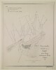
Distinctive Features:Hand drawn diagram enclosed with a letter no. C-113 dated 26th March 1936 (folios 145-149), compiled from a rough sketch made on the spot by the British Political Agent in Kuwait, Gerald Simpson DeGaury.Depicts an area of land disputed between Shaikh Ahmad Al Jaber Al Sabah of Kuwait and the Government of Iraq on which Colonel Ward, the Director of Basra Port, had applied to construct a camp for workers.Oriented with east to the top.1 mapMaterial:Pen and ink on paperDimensions:208 x 346 mm
Distinctive Features:Hand drawn sketch map of Umm Qasr sent with a copy of report by Colonel A.C Galloway dated 21th August (folios 89-91).Map prepared by the Base Survey Section showing the location of the proposed port at Umm Qasr, with landmarks lettered for reference and described in the report. Includes typewritten note in the bottom left-hand corner.1 mapMaterials:Pen and ink on paperDimensions:430 x 680 mm
Distinctive Features:Relief shown by shading.Routes between settlements shown in red pecked line.Inscriptions:On recto, upper right: ‘Recd. 12 may 1819, a true copy [illegible]’.1 map sheetMaterials:Pen and ink with wash on paperDimensions:438 x 280 mm, on sheet 447 x 290 mm
Distinctive Features:Reliefs shown by hachures. Shows the Jebel Dukhan promontory, Dohat et Zehrit, the surrounding shoals and water depth.Inscriptions:Descriptive notes on recto:Below the title: 'Soundings in feet corrected to lowest tide level observed to date 16/1/38.'1 map sheetMaterials: ink on paperDimensions: 342 x 290 mm; on sheet 369 x 333 mm.Foliation: The map has been foliated in the top right hand corner with a pencil number enclosed in a circle.
Distinctive Features:Reliefs shown by hachures.Shows the approaches to the Petroleum Development Jetty at Zekrit, in the Dohat of Zekrit; it also shows the Jebel Dukhan promontory and the surrounding shoals and water depth.Inscriptions:Descriptive notes on recto:Below the title: 'Soundings in FEET corrected to lowest tide level observed to date 16/1/38.'In the bottom right-hand corner: /Signed/ 'J.F.W.'1 map sheetMaterials: ink on paper.Dimensions: 340 x 350 mm; on sheet 362 x 372 mm.Foliation: The map has been foliated in the top right hand corner with a pencil number enclosed in a circle.
The map shows the Mekran Coast with telegraph line, roads and telegraph station. The scale is 2.5 inches to 20 miles.1 mapDimensions: 400mm (H) x 600mm (W)1 folio printed paper
Distinctive Features:Date ‘1867’ from pencil annotation in the bottom centre.Relief shown by hachures.Lettered for reference with explanation at lower left: ‘AA. Is portion of the territory formed by Muscat from Persia under terms of the treaty between those states.BB. with exception of the Choubar (Chābahār) District [marked in red] is under the sway of Belooch Chiefs who pay tribute to Persia through the GovernorThe strips of territory surrounded by red are possessions of Muscat’.Inscriptions:Descriptive notes on recto:Upper right: ‘For record in the geographical dept. An original map by Major (now Colonel) E.C. Ross, in his own handwriting and draughting [illegible] being pencil notes. I have not used the india rubber. Arthur W. Stiffe Lieuth’.Bottom margin, right: ‘The thin red Line is for Mekran Telegraph. The dotted line is for road’.1 map sheetMaterials:Pen and ink with wash on paper with additions in pencil
Dimensions:347 x 706 mm, on sheet 388 x 736 mm
Inscriptions:On recto of each sheet in the lower left-hand corner an annotation ‘Camp Kharg 22d July 1839’ and at bottom right-hand corner signature ‘C. Walker Lieut. Field Engineer’.On verso of each sheet in the upper left-hand corner inscription which relate to the sheet number and reads ‘Karrack’.6 mapsMaterials:Pen and ink with wash on paper
Distinctive Features:This is a photograph of the original manuscript which is held at IOR/X/3126/1. Reduced version of this map was lithographed and published in 1872 to accompany the Journal of Captain C. Bean Euan Smith. Printed copies at IOR/X/3126/3/1 and IOR/X/3126/3/2.Relief shown by hachures.Route of mission indicated in line with sextan observations points shown by dots. Boundaries of provinces coloured for reference on the original map.Inscriptions:Legends and annotations concerning the place names obscured via the reproduction process.On recto place names illegible or obscured through the reproduction process added in ink and pencil.1 map sheetMaterials:Photographic print with additions in pen and ink and pencilDimensions:260 x 968 mm
Distinctive Features:Undated. Date of production derived from the accompanying document.A photographic copy of Arabic plan relating to the deed of purchase for the land designated for the Jufayr Naval Base, with the seal of Shaikh Ḥamad bin ‘Īsá Āl Khalīfah, and signed by Charles Dalrymple Belgrave and M Khalil. Location and extent of the land boundaries stated in a Register [al-tasjīl]: No. 388, 1353; Tapu [al-ṭabū]: No. 13/566, 1352 (folios 90-91). Another copy of this plan hold at IOR/R/15/2/216, f. 91B.1 mapMaterials:Photographic printDimensions:332 x 285 mm, on sheet 352 x 302 mm
Distinctive Features:Undated. Date of production derived from the accompanying document.A photographic copy of Arabic plan relating to the deed of purchase for the land designated for the Jufayr Naval Base, with the seal of Shaikh Ḥamad bin ‘Īsá Āl Khalīfah, and signed by Charles Dalrymple Belgrave and M Khalil. Location and extent of the land boundaries stated in a Register [al-tasjīl]: No. 388, 1353; Tapu [al-ṭabū]: No. 13/566, 1352 (folios 90-91). Another copy of this plan hold at IOR/R/15/2/216, f. 91C.1 mapMaterials:Photographic printDimensions:332 x 285 mm, on sheet 350 x 302 mm
Distinctive Features:Undated. Date of production derived from the accompanying document.A photographic copy of Arabic plan relating to the deed of purchase for the land designated for the Jufayr Naval Base, with the seal of Shaikh Ḥamad bin ‘Īsá Āl Khalīfah, and signed by Charles Dalrymple Belgrave and M Khalil. Location and extent of the land boundaries stated in a Register: No. 407, 1353; Tapu: No. 511, 1352 (folio 91).1 mapMaterials:Photographic printDimensions:328 x 231 mm, on sheet 348 x 247 mm
The blueprint map shows the point at which the Afghan Persian Boundary, the Afghan British Boundary, and the Baluch Persian Boundary meet at Koh-I-Malik Seah [Malik Siah Koh or Malek Sīāh Kōh] mountain. Relief is indicated by contours.It is headed ‘Confidential’ and is signed by Lieutenant Frank Webb Ware, Political Assistant, Chagai. It forms part of a ‘Report on the Baluch-Persian Caravan Route and Nushki, Chagai and Western Sinjerani Districts, by Webb Ware, dated 1897 (folios 22-54 of Mss Eur F111/350).1 mapMaterials: Blueprint paperDimensions: 355 x 320mm
Map of a section of the border between Iran and Baluchistan (part of present-day Pakistan) around Kastag [Kastak]. The map is enclosed with reports and statements prepared by the Political Agent at Kalat in 1935 (ff 67-84), relating to an incident in which Iranian customs officials raided a shop owned by an individual named Juma Khan, which British officials understood to be in British territory. The map is annotated with letters (A-L) and numbers (1-4) indicating, amongst other things: settlements; topography; the Iranian customs post; the site where Juma Khan’s goods were looted.1 mapDimensions:325 x 190 mm.Materials:Ink on paper.
Distinctive Features:Relief shown by hachures.Blueprint of a map by Harold Richard Patrick Dickson, Lieutenant-Colonel, Political Agent to Kuwait. Shows the area occupied by the Al Murrah tribe and the approximate location of the other major tribes across the region with major towns and Bertram Thomas’ route across Al Khali (Empty Quarter) marked.1935Dimensions:392 x 330 mm
Distinctive Features:Blueprint sketch map compiled from a rough survey carried out by the Bahrain Petroleum Company, attached to a copy of a letter dated 7 December 1933 (folios 215-216).Shows land on Sitrah Island intended for the installation of the Bahrain Petroleum Company’s equipment including pumping plants, submarine line and oil tanks.1 mapDimensions:200 x 285 mm
Map of roads between Duzdap [Zahedan] and Meshed [Mashad]. The map and accompanying key indicate: posts were troops were stationed; halting stages for convoys; roads metalled in 1920; roads unmetalled in 1920 but since metalled (as of 1930); roads still unmetalled (as of February 1930); camel tracks not coincident with roads. The route is annotated with data about the road’s elevation, with ‘R.L.’ meaning reduce level, in reference to a datum of 1000 feet. Distances in miles along the road are also given. In the bottom left of the map is printed the statement: ‘D[rawing].O[ffice].S[imla].I. No. E 6102 8-30.’1 mapDimensions: 450 x 180 mm, on sheet 490 x 208 mm.Materials: Printed on paper.
The map is a General Staff India publication marked for official use only, and accompanies
MILITARY REPORT on PERSIA Vol. IV Part II. The map shows a region of central and southern Persia, indicating the names and locations of sedentary communities and the summer and winter quarters of migratory communities, cities, towns, and roads.The map bears a printing statement which reads 'Simla Drawing Office, No. 3425, April 1923.'.1 mapMaterials: Printed on paperDimensions: 398 x 323mm
The section of Admiralty chart number 1235 shows the mouth of the Shatt al-Arab on the Persian Gulf, with the frontier line between Iraq and Persia shown with a dashed line in pink pen. Depths are indicated with soundings, and the chart includes brief descriptions of topography.Scale not given.1 mapMaterials: Printed in black and white on paper, with additions in coloured penDimensions: On sheet 553 x 452mm
The chart section from Admiralty chart number 1235 shows the Abadan and Abdullah Banks at the mouth of the Shatt al-Arab on the Persian Gulf, with the low water line of the Abdullah Bank as determined in 1929 marked with a red line, and the low water line of the Abadan Bank as determined in 1929 marked with a green line.The approximate end of the frontier line between Iraq and Persia [Iran] according to the Turco-Persian Protocol of 1913 is marked with a dashed pink line. There is also a dashed pink line indicating three miles from the low water mark of the Abdullah Bank, and dashed green lines indicating three miles from the low water mark of the Abadan Bank, and three miles from the low water mark of the detached islet off the Abadan Bank. Depths are indicated with soundings, and the chart includes brief descriptions of topography.The chart bears the printing statement ‘London. Published at the Admiralty, 8th April 1921, under the superintendence of Rear Admiral Fred[eric]k C[harles] Learmonth, C.B., C.B.E., Hydrographer.’ and ‘New Edition 26th March 1923, 2nd March 1928.’Scale not given.1 mapMaterials: Printed in black and white on paper, with additions in coloured pen and paintDimensions: On sheet 425 x 503mm
Distinctive Features:General chart of the Persian Gulf published in 1832 by James Horsburgh and engraved by Richard Bateman. The western sheet only, lacking the title and publisher’s details.Relief in hachures. Depth shown by soundings.Nautical chart of the Persian Gulf compiled from the surveys carried out by the Bombay Marine’s officers between 1820 and 1829, with place names inserted in both English and Arabic.Gives detailed information on the coastline and waters of the Persian Gulf, including documenting pearl banks, rock banks, shoals and shallows. A memorandum is included in the bottom right corner of the map giving the surveys which it is based upon:'The coast from Ras Moosenden [Musandam] to Abothubbee [Abu Dhabi] was Surveyed by Lieuts J M Guy, G B Brucks and R Cogan in 1821 and 1822; from Abothubbee to Cape, or Ras Reccan, by Lieuts J M Guy and G B Brucks in 1823 and 1824; from the latter point to Core Abdullah by Lieuts Guy, Brucks and W E Rogers, in 1824 and 1825,- from Ras Tuloop to Bushire, in 1825-26, and the remainder of Coast, Islands etc by Lieuts G B Brucks and S B Haines from 1826 to 1829.'The map has been annotated with a red line to show the direction which Lewis Pelly travelled on leaving Koyt [Kuwait] for Riyadh and the direction he returned from to Bahrein [Bahrain] as well as the route that the H.M.S. "Berenice" BM took from Koyt to Bahrein to meet Lewis Pelly on his return. The top right hand corner of the map sheet contains a pencil annotation giving the longitude and latitude coordinates for Riyath [Riyadh]. Lewis Pelly departed from Kuwait in February 1865 and reached Bahrain in March 1865 and the annotations were made to the map sometime afterwards.1 mapDimensions:728 x 522 mm; on sheet 770 x 610 mmCondition:There are some small tears in the centre of the map where it has been folded and a stain mark along the bottom half of the left hand border of the map.Foliation:The map has been foliated in the top right hand corner of the folio with a pencil number enclosed in a circle.
The map, which bears an additional title: ‘Condition of the Duzdap-Meshed Road February 1930’, indicates the road between Duzdap [Zahedan] and Meshed [Mashad] and its suitability for motor transport (‘M.T.’) The key indicates the condition of the roads on the route: good; normally good, requiring repairs; fair; bad; and very bad condition. Key towns and villages on the road are also marked. Marked in the bottom left corner of the map is the statement: ‘D[rawing].O[ffice].S[imla].I. No. E 6101 8-30.’1 mapDimensions: 302 x 127 mm, on sheet 390 x 205 mm.Materials: Printed on paper.
Title from ‘A Catalogue of Manuscript and Printed Reports, Field Books, Memoirs, Maps, etc., of the Indian Surveys, Deposited in the Map Room of the India Office’ published in 1878.Series of nautical charts published in London by the Hydrographer to the East India Company.126 maps
Distinctive Features:Depths shown by soundings.Hand drawn nautical chart of the shores of the Persian Gulf compiled from the survey carried out by the Bombay Marine’s officers in 1823 showing Abothubbee [Abu Dhabi].Includes notes on water levels and soundings with latitude and longitude of the Fort reported.Oriented with south to the top.1 mapMaterials:Pen and ink on paperDimensions:643 x 741 mm, on sheet 675 x 802 mm
Imprint:Published by James Horsburgh, Hydrographer to the East India Company.Distinctive Features:Relief shown by hachures. Depth shown by soundings.Nautical chart of the Clarence Strait in the Persian Gulf compiled from the surveys carried out by the Bombay Marine’s officers between 1820 and 1829. Depicts the coastline of the mainland and the western part of the Island Kishm [Qeshm] with areas dry at low water stippled and indicated by a dotted line.Continuation of the map entitled ‘Sheet 1’ is held at IOR/X/3630/28/1.1 mapDimensions:526 x 699 mm, on sheet 562 x 774 mm
Imprint:Published by James Horsburgh, Hydrographer to the East India Company.Distinctive Features:Relief shown by hachures. Depth shown by soundings.Nautical chart of the shores of the Gulf of Oman showing the coastline between Muttra (Muttrah) and Muscat compiled from the surveys carried out by the Bombay Marine’s officers between 1820 and 1829. Settlements represented pictorially.1 mapDimensions:404 x 770 mm, on sheet 470 x 858 mm
Distinctive Features:Each of the pearl banks marked with a number. Shores not covered by water at low tide indicated by dotted lines. Includes a key which lists the names of the 110 numbered pearl banks in transliterated English.Above neat line at the bottom left-hand corner and centre illegible details obscured by smudged ink (probably imprint), followed by: ‘March 18, 1939. T.C.G’.1 mapDimensions:500 x 821 mm, on sheet 593 x 890 mm
Outline coastal views depicting the Arabian coast of the Persian Gulf drawn by Lieutenant Michael Houghton during the survey carried out by the Bombay Marine’s officers in 1821.2 items
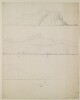
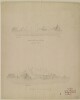
Distinctive Features:Two outline sketches in pencil with titles added in black ink: ‘Land forming the West.n side of Bunder Fuggum’ and in pencil ‘West of Aden’; and ‘Gibbul Shumsan from the Vessel at Anchor in Aden eastern bay’. Engraved copy at IOR/X/3224/1.Inscriptions:On recto in the bottom right-hand corner in pen and red ink: ‘Original Drawing engraved in the Chart of the several Bays near Cape Aden by Capt. Haines, 1836’.2 views on 1 sheetMaterials:Pencil with additions in pen and ink on paper.Dimensions:283 x 535 mm
This print shows the pearl banks along the Arabian coast of the Gulf, to the north of Ras Tanurah [Ra’s Tannūrah].1 mapDimensions: 477 x 433 mmMaterials: 1 paper folio
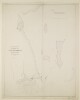
This vertical map illustrates three cross-sections of the Ahwar [Ahvaz] Rapids. The cross-sections are labelled 2945, 2860 and 2810. They correspond to reference numbers which can be found on the IOR/L/MIL/17/15/15, f 11.This item is one of three maps located on a larger sheet (folio 12).1 mapMaterials: Printed on paperDimensions: 75 x 510 mm
Distinctive Features:Produced to accompany the ‘Plan shewing the Old Line of Field Works across the Isthmus of Aden and the line of Permanent Works proposed for construction’ at IOR/X/3226.Sections lettered and numbered for reference which correspond to symbols present on the main plan. Measurements reported.Inscriptions:On recto of each sheet in the lower right-hand corner is an annotation:‘Signed W. JacobMajor ArtillerySigned C.W. GrantMajor Engineers’.‘On Special duty on the AdenDefences Bombay 11th September 1843’‘True Copy [faded] Lieut. J.A. CurtisExect. Engr. Aden’.On verso of each sheet is an annotation: ‘Enclosure No. 3 In Bombay Secret No. 7 1844’.6 sheetsMaterials:Pen and ink on paper
Distinctive Features:Produced to accompany the ‘Plan shewing the Old Line of Field Works across the Isthmus of Aden and the line of Permanent Works proposed for construction’ at IOR/X/3226.Sections lettered and numbered for reference which correspond to symbols present on the main plan. Measurements reported.Inscriptions:On recto of each sheet in the lower right-hand corner is an annotation:‘Signed W. Jacob Major ArtillerySigned C.W. GrantMajor Engineers’.‘On Special duty on the AdenDefences Bombay 11th September 1843’.‘True Copy[faded] Lieut. J.A. CurtisExect. Engr. Aden’.On verso of each sheet is an annotation: ‘Enclosure No. 3 In Bombay Secret No. 7 1844’.4 sheetsMaterials:Pen and ink on paper
Distinctive Features:Produced to accompany the ‘Plan shewing the Old Line of Field Works across the Isthmus of Aden and the line of Permanent Works proposed for construction’ at IOR/X/3226.Sections lettered and numbered for reference which correspond to symbols present on the main plan. Measurements reported.Inscriptions:On recto of each sheet in the lower right-hand corner is an annotation:‘Signed W. JacobMajor ArtillerySigned C.W. GrantMajor Engineers'.‘On Special duty on the AdenDefences Bombay 11th September 1843’.‘True Copy[faded] Lieut. J.A. CurtisExect. Engr. Aden’.On verso of each sheet is an annotation: ‘Enclosure No. 3 In Bombay Secret No. 7 1844’.5 sheetsMaterials:Pen and ink on paper
Distinctive Features:Shows administrative division with districts labelled for reference with boundaries indicated by pecked line.1 mapDimensions:195 x 330 mm, on sheet 335 x 388 mm
The map shows a region of central Palestine, indicating cities, towns, boundaries, railways, roads, tracks, hydrology, vegetation, cultivation and relief with contours and spot heights. The map consists of sections of Survey of Palestine 1:100,000 Series sheets 5, 6, 7 and 8 pasted together, and is intended to be placed behind the tracing paper map at folio 142.The map was compiled and drawn by the Survey of Palestine in 1935, with revisions made in 1937.1 mapMaterials: Printed in colour on paperDimensions: 520 x 500mm, on sheet 600 x 500mm
Sketch map of Bahrain and surrounding area showing proposed oil concessions in the Bahrain Unallotted Area. A letter from the Office of the Political Resident in the Persian Gulf to the Secretary of State for India dated 7 May 1938 (folios 573-576) refers to the sketch.The map shows proposed new concessions for Petroleum Concessions Limited (PCL), the Bahrain Petroleum Company (BAPCO), and the existing BAPCO lease. These are indicated by red dotted lines.Scale: 1.014 inches = 16 miles.1 mapMaterial: sketch on tracing paperDimensions: 330 x 220mm
Distinctive Features:Enclosed to letter from Charles Dalrymple Belgrave to Political Agent, Bahrain, dated 11th April 1934.Sketch map of Jafair with the land acquired by the Bahrain Government outlined in red. Properties numbered for reference corresponding with ‘List no.1. Payments by the Government of Bahrain to owners of property at Jafair’ (folio 76), reporting owners’ names, the approximate area of their land, particulars of buildings and gardens and the amount of money paid to them by the government as compensation.1 mapMaterials:Pencil and crayon on tracing paperDimensions:875 x 1000 mm
Distinctive Features:Relief shown by contours.Tracing of a sketch map of Abu Musa Island showing the iron oxide mine, an excavation site on the seashore, pier and anchorage.1 mapMaterials:Tracing on paper with additions in red ink and pencilDimensions:344 x 210 mm
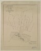
Distinctive Features:Copy of a tracing of an outline map attached to a letter no. C-182 dated 18th May 1934 (folios 313-319).Produced to show the position of a small island located south west of Warba within Kuwait territory with Kuwait boundary indicated by red dash-dot line. Al Tha’alib and vicinity marked in red and hatched; position of Um Qasr Fort shown.“B” inserted in blue crayon in the upper centre.1 mapMaterials:Pen and ink with crayon on tracing paperDimensions:204 x 330 mm
This photocopy of part of a map shows the mouth of the Shatt al-Arab on the Persian Gulf. It is labelled ‘Copy of part of map forwarded with Foreign Office letter N.B. The copy is not to the same scale as the map. Hydrographic Department Admiralty 22nd Jan[uar]y 1929.’Scale not given.1 mapMaterials: Printed in black and white on paper, with additions in coloured penDimensions: On sheet 553 x 452mm
A sketch map with countries and borders shown ranging from Oman in the west to China in the east. An area shaded in red indicates areas to be included in Air H.Q. India Bombing Target Catalogues (with a potential radius of action taken as 500 miles).1 mapMaterials: Printed on paperDimensions: 310mm x 300mm
Distinctive Features:Tracing attached to a letter dated 9 February 1909 (folio 125). Shows land near the Kārun River at Ahwaz with proposed site for a consulate. Properties labelled for reference with the approximate position of new buildings indicated by red pecked line and dimensions reported.1 mapMaterials:Pen and ink on tracing paperDimensions:200 x 327 mm
The map shows Koh-i-Malik Siah and the southern part of the boundary line between Afghanistan and Persia set by the Sistan Mission.Imprint: 'Zinco., S.I.O., Calcutta.'Distinctive features: the map is signed by George P Tate, Survey Officer [to the Sistan Mission], and Colonel Arthur Henry McMahon, British Commissioner, Seistan Arbitration Commission.1 map sheetMaterials: printed on paperDimensions: 570 x 800 mm on sheet 630 x 860 mmFoliation: the map has been foliated with a number written in pencil enclosed in a circle in the top right corner of the recto side of the folio.
Imprint:Ordnance Survey, 1921.Distinctive Features:Depth shown by soundings recorded in feet at low water.Plan of Shatt al ’Arab River near Qurna drawn from plan prepared by Lieutenant of H.M.S. ‘Espiegle’ showing the position of British forces on 4 December 1914, including location of the base camp, guns and ships with details of anchorage reported.1 mapDimensions:128 x 166 mm, on sheet 152 x 245 mm
Imprint:Ordnance Survey, 1921.Distinctive Features:Depth shown by soundings recorded in feet at low water.Plan of Shatt al ’Arab River near Qurna drawn from plan prepared by Lieutenant of H.M.S. ‘Espiegle’ showing the position of British forces on 8 December 1914, including location of the base camp, guns and ships with a note reporting Lewis Pelly reconnoitre.1 mapDimensions:126 x 165 mm, on sheet 152 x 245 mm
Map in blueprint showing the area of Khor Jarama [Khawr al Jarāmah], at Ras Al Hadd, Oman. The site was under discussion for use as an alighting area. The map also highlights an RAF petrol store.The map is prepared by G S Cooper, Civil Engineer, Air Headquarters, Iraq as part of a report titled ‘REPORT ON SOUTH ARABIAN COAST- INSPECTION TOUR- SEPTEMBER, 1942’. The map itself is marked as Appendix E.1 mapMaterials: blueprint.Dimensions: 310 x 190mm, on sheet 325 x 200mm
Map of Masira Island [Masirah Island xx Jazīrat Maşīrah], Oman. The map highlights the petrol stores, and the RAF and BOAC buildings which have been constructed at Ras Hilf. It also highlights the alighting area and Um Ras village at Um Rasas.The map is prepared by G S Cooper, Civil Engineer, Air Headquarters, Iraq as part of a report titled ‘REPORT ON SOUTH ARABIAN COAST- INSPECTION TOUR- SEPTEMBER, 1942’. The map itself is marked as Appendix F.The scale at Ras Hilf is approximately 1.5 inches to 1 mileThe scale at Um Rasas is approximately 1 inch to 1 mile1 mapMaterials: blueprint. Dimensions: 328 x 200mm.
A sketch map of Bait Al-Falaj landing ground with an envelope. The map shows the proposed concrete runways in dotted lines. The map is drawn by the Air Liaison Officer at Muscat and it is part of a letter (ff 3-4) sent to the Air Headquarters, British Forces in Iraq.1 mapMaterials: manuscript ink and pencil on tissue paper.Dimensions: 687 x 432mm.
Sketch map of Persia showing telegraph lines (in black); and British (red) and Russian (green) consulates general, consulates, and vice consulates, as described in a key in the bottom right hand corner of the map.The map forms part of a letter from Sir Henry Mortimer Durand, HBM's Minister at Tehran, to the Marquess of Salisbury, the Secretary of State for Foreign Affairs, dated 12 February 1899, concerning the question of the appointment of additional consular officers in Persia (folios 7-17). The letter draws attention to the large scale of the Telegraph Department in Persia, and its numerous staff of English clerks, which according to the letter constituted a valuable organisation for political and intelligence purposes, especially in remote places (folio 10v).Scale 60 miles = 1 inch.1 mapMaterials: Printed on paper.Dimensions: 510 x 650mm.
Imprint:Berlin, Published by Simon Schropp’schen Hof-Landkartenhandlung (L. Beringuier u. Ad. Berg.).Distinctive Features:Relief shown by hachures.Countries and provinces coloured for reference with a key in the bottom centre.Includes a table of Persian and Arabian words with German equivalent terms in the bottom right.Labels:On the recto in the bottom right-hand corner blind stamp: ‘LANDKARTEN HANDUNG J.H. NEUMANN BERLIN’1 map sheetDimensions:626 x 915 mm, on sheet 691 x 955 mm
Imprint:Berlin, Published by Dietrich Reimer. Lithographed by Ansalt von L. Kraatz.Distinctive Features:Relief shown by hachures.Includes a table with place names and abbreviations in multiple languages and a key to symbols and colours in the bottom centre.Shows the domains of the Ottoman Empire in the mid-nineteenth century.1 map sheetDimensions:820 x 1170 mm, on sheet 918 x 1270 mm
Imprint:London, published by William Faden, Geographer to the King and to the Prince of Wales, Charing Cross.Statement of responsibility:Engraved by William Palmer.Distinctive Features:Title continues: ‘Situm Ac Nomina Locorum Recentioris Aevi Sub Oculos Subjiciens Nec Non Alexandri Itinera Intra Euphratem Et Hyphasin Et Navigationem Nearchi Ab Indo Flumine Ostium Usque Pasitigris’.Relief shown by shading.Place names given in both Latin and English.Land routes shown in red; sea routes and waterways coloured green.1 map sheetDimensions:246 x 296, on sheet 383 x 429 mm
Distinctive Features:Above map at top left: ‘Zum Atlas von Vorder-Asien gehörig, Heft V, Arabien’.Relief shown by hachures.Shows the approximate location of the major nomadic tribes across the region.1 map sheetDimensions:405 x 475 mm, on sheet 604 x 690 mm
Distinctive Features:Relief shown by hachures.Title continues: ‘Zu C. Ritter’s Erdkunde, Buch III, West-Asien, Theil VIII, IX. Bearbeitet von H. Kiepert, herausgegeben von C. Ritter. Berlin, 1852 Verlag von Dietrich Reimer’.Map of western portion of Persia showing various routes in the region including route traversed by James Justinian Morier in 1808; John Macdonald Kinneir’s expedition of 1813-14; and tour of Baron C. A. De Bode from Teheran through Ispahan and Persepolis to Shiraz. Borders outlined in colour.In the bottom right-hand corner there is a table of reference listing Persian, Turkish and Arabic geographic terms with German equivalents and abbreviations.Includes an inset map entitled 'Schîraz, Persepolis und Umgegend'.1 mapDimensions: 464 x 354 mm, on sheet 482 x 474 mm
Imprint:War Office, April 1912. Additions, July 1918. Railways revised, October 1928. Geographical Section. General Staff. No. 2149.Distinctive Features:Relief shown by gradient tints and spot heights.International boundaries coloured green with districts labelled. Shows various railways including lines under construction and proposed lines (i.e. the Trans-Iranian Railway completed in 1938). Contains table of reference.1 mapDimensions:494 x 763 mm, on sheet 573 x 832 mm
The map shows the Haqiqah Channel and also indicates hydrology and settlements, with brief descriptions of topography and vegetation, and provides some indication of relief. A short note describes how the land is inundated from January to May and a further note describes the channels further and the availability of good water and fodder.The map bears the printing statement: 'Intelligence Branch General Staff I.E.F. "D" 19.19.15. Map Serial NO.66.'1 mapMaterials: Printed on paperDimensions: 400 x 600mm