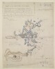
The map shows the limits of Koweit [Kuwait] and adjacent country indicating relief, hydrology and settlement. A line in red ink and a boundary in green ink indicates different possible boundaries. It is included as Annex number 5 to the Anglo-Turkish Agreement, as part of the collection of documents signed 29 July, 1913.The map is signed by Edward Grey and another signatory [Ibrahim Hakki Pasha].1 mapMaterial: Printed on paper.Some parts of the map are missing at the edges.Dimensions: 400 x 330mm, on sheet 480 x 470mm
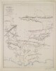
The map shows the Persian Gulf and Arabian Coast naming the settlements, regions and bays; the map also indicates the Indo-European overland and submarine telegraph lines and roads. Some brief descriptions of topography are given.The map is signed in the bottom right hand corner by Edward Grey and I Hakky [Ibrahim Hakky Pasha].The map was included as 'Annexe Numero 5A' to the Anglo-Turkish Agreement as part of the collection of documents signed 29 July, 2013.The scale is given as 1:3801600 or 1 inch to 60 miles.1 mapMaterials: Printed in colour on paperDimensions: 450 x 470mm, on sheet 490 x 550mm
The map shows the Persian Gulf and Arabian Coast naming the settlements, regions and bays; the map also indicates the Indo-European overland and submarine telegraph lines and roads. Some brief descriptions of topography are given.The map was included as 'Annexe Numero 5A' but in the file is separated from the report to which it is an annex.The scale is given as 1: 3801600 or 1 inch to 60 miles.1 mapMaterials: Printed in colour on paperDimensions: 450 x 470mm, on sheet 490 x 550mm
The map shows the British telegraph station and its surroundings on the northern tip of the island of Henjam [Jazīreh-ye Hengām]. The map indicates, with annotations: the location of the telegraph station and office buildings; other buildings, including the Persian customs house, labourers’ huts; water tanks; tracks; Persian flagstaffs, geological features, including cliffs, beaches and salt deposits; cultivation and garden areas. Two lines are marked on the map in red ink. The first indicates the suggested southern boundary line of the telegraph station; the second line connects the telegraph buildings and telegraph office (possibly denoting a cable). The annotations for the Persian customs house and Persian flagstaffs are underlined in red ink.1 mapMaterials:pen and ink on tracing cloth.Dimensions:490 x 540 mm.Foliation:The map is foliated with a circled pencil number in the top right corner.
A simple blueprint map of an area of land in Manamah bought by the British Government in 1934. The extent of the land is marked by boundary pillars.1 mapMaterials: printed on drafting clothDimensions: 350mm x 480mm
Distinctive Features:Blueprint plan based on a provisional survey carried out on 22 July 1934 enclosed to a copy of a ‘Report on areas acquired in Bahrein’ by Major K.M. Papworth (folio 187).Shows the extent of the plot situated about 1 ½ miles south of Manamah on the east coast of Bahrein in the close proximity to the existing RAF Rest House. Dimensions reported.Land characteristics, including information on marking, surface, wells, obstructions, communication and present occupation, described in 'Appendix B’ (folios 190-191).1 mapDimensions:505 x 363 mm
This vertical map of the Ahwar [Ahvaz] Rapids illustrates the probable maximum high flood level and probable ordinary high flood level, and the rock types and heights, found at the longitudinal section of main line of rocks.This item is one of three maps located on a larger sheet (folio 12).1 mapMaterials: Printed on paperDimensions: 105 x 510mm
This vertical map of the Ahwar [Ahvaz] Rapids illustrates the probable maximum high flood level and probable ordinary high flood level, and the rock types and heights, found at the longitudinal section of the main line of rocks on the plan of the Rapids (IOR/L/MIL/17/15/15, f 11).This item is one of three maps located on a larger sheet (folio 12).1 mapMaterials: Printed on paperDimensions: 135 x 510 mm
Copy of a map, referred to in an accompanying a letter written by Colonel Arthur Henry McMahon, British Commissioner, Seistan [Sīstān] Arbitration Commission, dated 5 November 1904 (ff 236-241). The letter refers to the boundary between Persia [Iran] and Baluchistan [in present-day Pakistan] around Mirjawa [Mīrjāveh], as established in an agreement of 1896.The map indicates: hydrology; topography, with some indication of relief; trigonometrical stations, with heights indicated in feet; settlements; trade routes. The frontier lines discussed in McMahon’s letter are marked in blue and red pencil.The original map was published under the direction of Major Francis Becon Longe, Officiating Surveyor General of India, in May 1902.1 mapDimensions:310 x 495 mm, on sheet 410 x 550 mm.Materials:Photocopy on paper, with pencil additions.
Blueprint map of Bahrain showing the proposed area for an oil concession covering the shoal area of Bahrain.The proposed concession area is marked with a single red line and covers the territorial waters and islands to the North and East of Bahrain, excluding the Hawar Islands. Within the north area of the concession area longitude and latitude co-ordinates are marked with red ink.The map also shows two reserved areas, both marked with diagonal red lines. One area covers Muharraq Island, the other covers an area on the north-west coast of the Bahrain mainland.The Hawar Islands have been circled with a thick red line and coloured yellow.Map enlarged in the Land Department, Government of Bahrain.1 map sheetFoliation: The map has been foliated using a pencil number, enclosed in a circle, located in the top right hand corner of the folio.Materials: Parchment blueprint sheetDimensions: 700mm x 555mm
Blueprint map of Bahrain showing the proposed area for an oil concession covering the Hawar Islands.The proposed concession area has been coloured red on the map.Map enlarged in the Land Department, Government of Bahrain.1 map sheetFoliation: The map has been foliated using a pencil number, enclosed in a circle, located in the top right hand corner of the folio.Materials: Parchment blueprint sheetDimensions: 710mm x 545mm
Map showing the first of two proposed concession areas which Petroleum Concessions Limited (PCL) hoped to acquire from the Shaikh of Bahrain, identified as 'Leased Area No. 1'.The leased area which the Company hoped to acquire is marked with a red line and covers the islands of FASHT AL JARIM [Fasht al Jārim] and KHOR FASHT [Khawr Fasht]. The map also shows part of the coast of the main island of Bahrain, with one area marked with red lines to illustrate the area where PCL wished to obtain surface rights.Also included is a green line which marks the northern boundary of the Bahrain Petroleum Concession granted in 1925.Part of Admiralty Chart No. 3790 (1933-34).Longitude and latitude lines are marked on the map.1 mapMaterials: blueprint on tracing paperDimensions: 330 x 230mm
Map showing the first of two proposed concession areas which Petroleum Concessions Limited (PCL) hoped to acquire from the Shaikh of Bahrain, identified as 'Leased Area No. 1'.The leased area which the Company hoped to acquire is marked with a red line and covers the islands of FASHT AL JARIM [Fasht al Jārim] and KHOR FASHT [Khawr Fasht]. The map also shows part of the coast of the main island of Bahrain, with one area marked with red lines to illustrate the area where PCL wished to obtain surface rights.Also included is a green line which marks the northern boundary of the Bahrain Petroleum Concession granted in 1925.Part of Admiralty Chart No. 3790 (1933-34).Longitude and latitude lines are marked on the map.1 mapMaterials: printed on paperDimensions: 320 x 210mm on sheet 340 x 240mm
Map showing the first of two proposed concession areas which Petroleum Concessions Limited (PCL) hope to acquire from the Shaikh of Bahrain, identified as 'leased area no. 1'.The leased area which the Company hopes to acquire is marked with red line and covers the islands of FASHT AL JARIM [Fasht al Jārim] and KHOR FASHT [Khawr Fasht]. The map also shows part of the coast of the main island of Bahrain, with one area marked with red lines to illustrate the area which PCL wished to obtain surface rights.Also included is a green line which marks the northern boundary of the BAPCO (Bahrain Petroleum Concession) as granted in 1925.Part of Admiralty Chart No. 3790 (1933-34).Longitude and Latitude lines are marked on the map.1 map sheetMaterials: 1 parchment folioDimensions: 344mm x 235mmFoliation: The map sheet has a foliation number in the top right hand corner of the folio. The number is enclosed by a circle.
Blueprint map, forming part of draft oil concession, dated 1938, showing the first of two proposed concession areas which Petroleum Concessions Limited (PCL) hoped to acquire from Shaikh Sir Hamad bin Isa al Khalifah [Ḥamad bin ‘Īsá Āl Khalīfah], Ruler of Bahrain (folios 438-458). The area is identified as 'Leased Area No. 1'.The leased area which the Company hoped to acquire is marked with a red line and covers the islands of FASHT AL JARIM [Fasht al Jārim] and KHOR FASHT [Khawr Fasht]. The map also shows part of the coast of the main island of Bahrain, with one area marked with red lines to illustrate the area where PCL wished to obtain surface rights.Also included is a green line which marks the northern boundary of the Bahrain Petroleum Concession granted in 1925.Part of Admiralty Chart No. 3790 (1933-34).Longitude and latitude lines are marked on the map.1 mapMaterials: blueprintDimensions: 330 x 220mm
Map showing the second of two proposed concession areas which Petroleum Concessions Limited (PCL) hoped to acquire from the Shaikh of Bahrain, identified as 'Leased Area No. 2'.The leased area which the Company hopes to acquire is marked with red line and covers the Hawar group of islands and Fasht ad D'bal [Fasht ad Dībal]. The map also shows the bottom right corner of Leased Area No. 1.Part of Admiralty Chart No. 2837B.Longitude and latitude lines are marked on the map.1 mapMaterials: blueprint on tracing paperDimensions: 660 x 510mm on sheet 690 x 540mm
Map showing the second of two proposed concession areas which Petroleum Concessions Limited (PCL) hopes to acquire from the Shaikh of Bahrain, identified as 'leased area no. 2'.The leased area which the Company hopes to acquire is marked with red line and covers the Hawar Group of islands and Fasht ad D'bal [Fasht ad Dībal]. The map also shows the bottom right corner of leased are No. 1.Part of Admiralty Chart No. 2837B.The verso of the map sheet contains a note from the Political Agent at Bahrain that the maps were enclosed with a letter 28/4138 from the India Office and should be attached to the draft Bahrain Lease from Petroleum Concessions Limited.Longitude and Latitude lines are marked on the map.1 map sheetMaterials: 1 parchment folioDimensions: 675mm x 540mmFoliation: The map sheet has a foliation number in the top right hand corner of the folio. The number is enclosed by a circle.
Map showing the second of two proposed concession areas which Petroleum Concessions Limited (PCL) hoped to acquire from the Shaikh of Bahrain, identified as 'Leased Area No. 2'.The leased area which the Company hopes to acquire is marked with a red line and covers the Hawar group of islands and Fasht ad D'bal [Fasht ad Dībal]. The map also shows the bottom right corner of Leased Area No. 1.Part of Admiralty Chart No. 2837B.Longitude and latitude lines are marked on the map.1 mapMaterials: printed on paperDimensions: 660 x 510mm on sheet 690 x 540mm
Blueprint map, forming part of draft oil concession, dated 1938, showing the second of two proposed concession areas which Petroleum Concessions Limited (PCL) hoped to acquire from Shaikh Sir Hamad bin Isa al Khalifah [Ḥamad bin ‘Īsá Āl Khalīfah], Ruler of Bahrain (folios 438-458). The area is identified as 'Leased Area No. 2'.The leased area which the Company hopes to acquire is marked with red line and covers the Hawar group of islands and Fasht ad D'bal [Fasht ad Dībal]. The map also shows the bottom right corner of Leased Area No. 1.Part of Admiralty Chart No. 2837B.Longitude and latitude lines are marked on the map.1 mapMaterials: blueprintDimensions: 660 x 510mm, on sheet 680 x 540mm
Imprint:Heliozincographed at the Survey of India Offices, Calcutta. M.A. Hakimkhan, Draftsman.Distinctive Features:Sketch map showing the river system between Nasiriyah and Qurnah produced to illustrate ‘Report on the Development of Mesopotamia’. Title continues: ‘Produced by Survey Party I.E.F. [Corps of Indian Engineers] “D.” No. 43 Dated 17.3.16 after completing the Field Surveys’.Classified ‘For Official Use Only’.Bottom left-hand corner below map: ‘Reg. No. 1330. E 17’.1 mapDimensions:500 x 1255 mm, on sheet 630 x 1470 mm
The scale of the map is 1.014inch = 16miles.The map was printed by the Simla Drawing Office and includes the printing statement ‘S. D. O. No. 2428, Dec. 1918’.1 mapMaterials: Printed in colour on paperDimensions: 470 x 415mm, on sheet 550 x 445mm
Printed map with hand drawn additions. The map has two subtitles at its top: ‘Afghānistan, Baluchistān & Persia’ and ‘Sheet No. 30 Sīstān’, and is also labelled ‘Map No. 1, 2nd Edition (1928)’. It was published under the direction of Colonel Sir Sidney Gerald Burard, Surveyor General of India, 1918. The printed map indicates: hydrology; topography, with contours and heights; settlements; roads and railways; boundaries (international, province/state, district/tribal).The hand drawn additions to the map, with accompanying key, were made and signed by Captain Guy Bomford of the Royal Engineers and Superintendent of the Survey of India. They are: vertical blue lines indicating the area covered by the Indian Survey of 1932; horizontal blue lines indicating the Persian survey up to 11 May 1932; and solid pink regions indicating uninhabitable areas.The map is referred to in a copy of a secret letter from Bomford to the Surveyor General of India, dated 7 June 1932 (ff 113-114).1 mapDimensions:460 x 410 mm, on sheet 605 x 540 mm.Materials:printed on paper, with ink additions.
The map displays British India's border region with Afghanistan and Eastern Persia, illustrating the areas prohibited to civil aircraft. It demarcates the external boundary of British India, along with its internal and district boundaries; railway lines are also indicated. It also contains a schedule of prohibited areas. The scale is 1 inch to 64 miles, and was heliozincographed at the Survey of India Offices in Calcutta.Two inset maps have been included illustrating areas prohibited to civil aircraft around Bombay and Karachi. The scale of these maps is 1 inch to 2 miles.1 mapDimensions:353 mm x 352 mmMaterials: 1 paper sheet
The map was produced by the Bahrain Petroleum Company (BAPCO), and was originally produced on 9 September 1938. Includes list of revisions to 27 February 1939.The map shows existing marked barge channel, and routes (listed A, B, C, D), from Zellaq, Bahrein [Bahrain] to [Saudi] Arabia, and entrance channel. Also shows Khobar Terminal, Saudi Arabia, and Bird Island. Includes notes on soundings and bottom.Inset: marginal map (scale 1:25,000), showing South Twin Dune, Saudi Arabia.A letter from the Political Agent, Bahrain (Hugh Weightman) to the Political Resident in the Persian Gulf (Sir Trenchard Craven William Fowle), on folios 70-74, relates to the map.1 mapMaterials: blueprint on paper.Dimensions: 660 x 980mm, on sheet 700 x 1010mm.
Black-and-white printed map, which is part of a larger document entitled
Navy (Fuel Oil).Agreement with the Anglo-Persian Oil Company, Limited, published by HM’s Stationery Office, 1914 (ff 301-319). The map shows Persia, highlighted red with a thick red outline, and its neighbours, including the Persian Gulf, Arabia, Afghanistan, the Indian Empire, and a number of states to the north including Azerbijan [Azerbaijan], Gilan [Ostān-e Gīlān], Mazanderan [Māzandarān], Astrabad [Gorgān], and Khorasan. Towns and cities of varying size and importance are indicated across the region, with the names of larger or more important settlements rendered in larger capitals. Proven oil well areas are marked by green rectangles, and reported oil shows are marked with green circles. The Anglo-Persian Oil Company’s pipeline, linking their oil field in Arabistan to the refinery at Abadan, is indicated by a dotted black line.1 mapDimensions:310 mm x 420 mm.Foliation:The map is foliated in the top right corner by a circled pencil number.Materials:1 paper folio.
Distinctive Features:Blueprint sketch map produced by the Bahrein Petroleum Company, dated 14 August 1935, enclosed in a letter no. PA-247 (folio 205).Shows the land required for the purpose of drilling and operating water wells with oil pipeline and submarine line marked.1 mapDimensions:250 x 180 mm, on sheet 270 x 180 mm
Blueprint map showing proposed oil concession area to be granted by Shaikh Sir Hamad bin Isa Alkhalifah [Ḥamad bin ‘Īsá Āl Khalīfah], Ruler of Bahrain, to the Bahrain Petroleum Company (BAPCO).The map states: 'Enlarged in Land Department. Government of Bahrain'.The map is referred to in a letter dated 7 May 1938, with accompanying schedules, from Charles Dalrymple Belgrave, Adviser to the Government of Bahrain, to the Political Agent, Bahrain (folios 579-590). The BAPCO concession area is edged in red.1 mapMaterials: blueprintDimensions: 670 x 460mm, on sheet 730 x 520mm
Sketch map of Basidu, based on an Admiralty chart. The map provides some indication of settlements and vegetation.1 mapMaterials: Manuscript; black ink, pencil and coloured crayon on paper.Dimensions: 159 x 181mm, on sheet 201 x 333mm.
Imprint:General Staff India. S.D.O. No. 1250, June, 1915.Distinctive Features:View of Shaiba battlefield and surrounding area issued as an ‘Appendix 13’ to illustrate British military operations on the 13th April 1915 showing the movements of British and enemy forces with landmarks labelled for reference. Contains an explanatory note inserted below title.Bottom right hand corner: ‘(Sd.) G.F.R. Wingate, Captain R. A., 20-4-1915’.Marked ‘For Official Use Only’.Oriented with west to the top.1 viewDimensions:171 x 530 mm
Imprint:General Staff India. S.D.O. No. 1251, June, 1915.Distinctive Features:View of Shaiba battlefield and surrounding area issued as an ‘Appendix 14’ to illustrate British military operations on the 13th April 1915 with landmarks labelled for reference.Bottom right hand corner: ‘(Sd.) G.F.R. Wingate, Captain R.A., 20-4-1915’.Marked ‘For Official Use Only’.1 viewDimensions:171 x 557 mm
Imprint:General Staff India. S.D.O. No. 1248, June, 1915.Distinctive Features:View of Shaiba battlefield and surrounding area issued as an ‘Appendix 12’ to illustrate enemy’s military operations on the 13th April 1915 with landmarks labelled for reference.Bottom right hand corner: ‘(Sd.) G.F.R. Wingate, Captain R. A., Shaiba 20-4-1915’.Marked ‘For Official Use Only’.1 viewDimensions:145 x 271 mm
The sheet contains a section map: Burbarūd—Kaleh Huma—Makhadī [Makdīn-e Pā’īn]—Bāznawī—Pul-I-Shīrak—Pul-I-Kul—Dizfūl in south-western Persia. It is found in the
Military Report on S. W. Persia, Vol. III. Bakhtiāri Country North of Kārūn Rivercompiled in the Division of the Chief of the Staff, Army Head Quarters, India. It shows a cross-sectional view of the route.The map includes a printing statement which reads 'I. B. Topo. Dy. No 8,174. Exd. C. J. A., July 1909. No. 4,909-I., 1909.'.Vertical scale: 1:72,0001 mapMaterials: Printed on paperDimensions: 214 x 639mm
Newspaper cutting from an unknown paper with date ‘Tues May 17th 1913’ inserted in black ink at top of the page.Distinctive Features:Relief shown by hachures.Map of the Persian Gulf region issued with an article ‘British Interest in the Gulf’ to illustrate the Baghdad Railway with proposed terminus in Basra. Also shows wireless telegraph stations in Mekran and Sharga.1 mapDimensions:106 x 135 mm
The map is printed in four colours, with each colour being used to indicate a different category of features:blue: hydrographical features, including the river systems of the Euphrates and Tigris, canals, marshes and lakes, and their names. Notes on the flooding characteristics of different geographical regions are also indicated in blue;green: agriculture, with rice cultivation marked in green, and other forms of cultivation marked in light green;brown: physical topography, including mountains and ridges;black: towns and villages, transport infrastructure (railways and roads) as well as place names and notes on topographical features.Below the map is a key, scale, and information on the creation history of the map, with details of the various sources of additional information used in its production.1 mapDimensions:760 x 640 mm.
The map shows cultivation in Lower Mesopotamia [Iraq] between Baghdad and the Persian Gulf. Rice cultivation is shown in dark green, while other cultivation is shown in light green. The map also shows the positions of settlements, rivers, railways, and highlights mountainous terrain. The Turco-Persian boarder is also outlined.The scale of the map is recorded as 1:1,000,000 or 1.014 inches to 16 miles. It was lithographed at the War Office in November 1907; additions and corrections were made in August 1916, and the railway network was revised June 1919.A reference key can be found in the bottom left corner of the map, and a list of sources of additional information can be found in the bottom right corner.The map bears the printing statement ‘Geographical Section, General Staff No. 2563’.1 mapMaterials: Printed on paperDimensions: 575 x 583mm, on sheet 758 x 640mm
Imprint:Heliozincographed at the Survey of India Offices, Dehra Dun. Reg. No. 218 E.D.D. 1914 General Staff.Distinctive Features:Relief shown by hachures.General map of the Lower Mesopotamia showing communication features including roads, canals and telegraph lines issued to illustrate report compiled by the Army Headquarters entitled 'Plan for operations in Turkish Mesopotamia'.1 mapDimensions:385 x 413 mm, on sheet 551 x 700 mm
Imprint:Heliozincographed at the Survey of India Offices, Dehra Dun. Reg. No. 218 E.D.D. 1914 General Staff – 500.Distinctive Features:Relief shown by hachures.General map of the Lower Mesopotamia showing communication features including roads, canals and telegraph lines issued to illustrate report compiled by the Army Headquarters entitled 'Plan of operations for the support of Muhammareh'.1 mapDimensions:385 x 413 mm, on sheet 550 x 700 mm
Imprint:Heliozincographed at the Survey of India Offices, Dehra Dun. Reg. No. 218 E.D.D. 1914 General Staff – 500.Distinctive Features:Relief shown by hachures.General map of the Lower Mesopotamia showing communication features including roads, canals and telegraph lines issued to illustrate report compiled by the Army Headquarters entitled 'Plan of operations for the support of Muhammareh'.1 mapDimensions:385 x 413 mm, on sheet 551 x 700 mm
The map accompanies
The Campaign in Mesopotamia 1914-1918. Volume I, and shows portions of Arabia, Persia and Kuwait, indicating boundaries, cities, towns and roads. Some relief is shown with hachures, and seas, rivers and marshes are printed in blue.Prepared in the Historical Section of the Committee of Imperial Defence, and printed at the Ordnance Survey in June 1922.1 mapMaterials: Printed on paperDimensions: 265 x 282mm, on sheet 343 x 343mm
The map accompanies
The Campaign in Mesopotamia 1914-1918. Volume II, and shows portions of Arabia, Persia and Kuwait, indicating boundaries, cities, towns and roads. Some relief is shown with hachures, and seas, rivers and marshes are printed in blue.Prepared in the Historical Section of the Committee of Imperial Defence, and printed at the Ordnance Survey in 1924.1 mapMaterials: Printed on paperDimensions: 264 x 282mm, on sheet 340 x 362mm
Imprint:London, Stanford’s Geographical Establishment, Charing Cross.Distinctive Features:Shows telegraph line to India; submarine telegraph cable laid in 1864 and 1869; various routes including Pottinger’s 1810 expedition from Nushki (Balochistan) to Isfahan; boundaries and frontiers.Below title: ‘Table showing the approximate value of the Roman letters used in the names of places on the Map’.Includes four sections:• between the Persian Gulf and Bampúr Valley;• between the Persian Gulf and the Kharán Desert about the meridian of 63° Valley;• along the high road between Shiráz, Karmán, Bampúr & the edge of the Kharán or Halmand Desert;• between the Persian Gulf and the Caspian along the high road through Busire, Shiráz, Isfahán and Teherán.1 map on 12 sheetsDimensions:1800 x 1900 mm, each sheet 480 x 660 mm
The map, produced by the War Office, shows the existing and the projected railways in Persia and Afghanistan, as well as the 'Proposed limits of Mining Concession', and the 'Limits of British and Russian Spheres' in the area.1 map
Map of part of the territory on the Persia [Iran] and Baluchistan (part of present-day Pakistan) frontier, published under the direction of Colonel Sir Sidney Gerald Burrard, Surveyor General of India, 1915. The map indicates: relief, with form lines; hydrology; roads; settlements; boundaries, including the boundary between Persia and Baluchistan.The map accompanies papers and correspondence dated 1935 that relate to a dispute between the British and Persian Governments over the position of the border around Kuhak [Nūk Jow], Persia. The map is specifically referred to in a Foreign Office minute dated 20 December 1935, entitled ‘Alleged Intrusion of British Levies into Persian Territory near Kuhak.’ (ff 220-221).1 mapDimensions:460 x 420 mm, on sheet 590 x 476 mm.Materials:Printed in colour on paper.
Map numbered 1.B (Khoī [Khoy]), and subtitled ‘Azarbāījān [Azerbaijan] Province & Van Vilayet.’ An index to the geographical location of the provinces is provided below the map. A caption under the map states that it was published under the direction of Colonel Charles Henry Dudley Ryder, Surveyor General of India, 1922. A stamp in the bottom right corner of the map states that it was published by the Geographical Section General Staff, War Office.The map indicates: relief, shown by contours and shading, with elevations given in feet; rivers, lakes, marshes; province and country boundaries; settlements, with place names in English; railways, roads and other transport routes. An additional boundary line, drawn in red ink, has been added to the map.The map is mentioned in a copy of a letter sent by HM’s Envoy Extraordinary and Minister Plenipotentiary at Tehran (Reginald Hervey Hoare) to the Secretary of State for Foreign Affairs (John Allsebrook Simon), dated 1 July 1932, which states that the ‘Turkish military attaché has been so good as to draw upon sheets 1 A, 1 B, and 1 C [...] the line of the new frontier’ (f 48).1 mapMaterials:1 paper folio.Dimensions:464 x 374 mm, on sheet 630 x 444 mm.
The map accompanies a report titled ‘Air Transport in Persia – 1944 and afterwards’ by Walter Leslie Runciman, Air Attaché at Tehran: see folios 119-129. It shows Persia [Iran] in the centre bounded by Iraq to the East, Afghanistan and Baluchistan to the West, the Caspian Sea in the North, and the Persian Gulf and the Gulf of Oman in the South. It illustrates existing air routes between Tehran, and the following places: Meshed, Baghdad, and Tabriz. It also indicates proposed future routes connecting Tehran-Isphahan-Kerman-Zahidan and Tehran-Isphanan-Shiraz-Bushire. Annotations in red ink indicate the approximate distance of these routes in miles.Shading on the map is used to indicate areas of salt deserts and mountainous regions over 5000 feet. Railway lines and national borders are also marked on the map.1 mapDimensions: approximately 555 x 510mm, on sheet 603 x 605mmMaterials: Printed on paper, with manuscript additions in red ink
Map showing Persia, Afghanistan, and Baluchistan. Compiled under the supervision of George Nathaniel Curzon by William J Turner, Fellow of the Royal Geographical Society. The map was issued with the Proceedings of the Royal Geographical Society for February 1892 and reproduced in the Intelligence Division, War Office, under the direction of Lieutenant Colonel CJ Dalton from transfers supplied by the Council, Royal Geographical Society.The map show details of physical geography, settlements, roads, railways, and telegraph lines.1 mapMaterials: Printed on paperDimensions: 505 x 627mm, on sheet 554 x 792mm
The map shows Persia, Afghanistan and Baluchistan and indicates hydrology, settlements and topography.The outline of the border of Persia is shown by a red line, the border of Aghanistan by a green line, and the boundary of Baluchistan by a yellow line. A table of 'significations' gives Persian terms and their English equivalents, for example, 'Bunder' and 'Harbour'.1 mapMaterials: Printed in colour on paperDimensions: 550 x 650mm
Map numbered 1.A (Mount Ararat), and subtitled ‘Azarbāījān [Azerbaijan] Province. Erivan [Yerevan]. Erzerum [Erzurum] & Van Vilayets.’ An index to the geographical location of the provinces is provided below the map. A caption under the map states that it was published under the direction of Colonel Charles Henry Dudley Ryder, Surveyor General of India, 1922. A stamp in the bottom right corner of the map states that it was published by the Geographical Section General Staff, War Office.The map indicates: relief, shown by contours and shading, with elevations given in feet; rivers, lakes, marshes; province and country boundaries; settlements, with place names in English; railways, roads and other transport routes; the Indo-European Telegraph Line. A new boundary line, drawn in red ink with annotations, has been added to the map.The map is mentioned in a copy of a letter sent by HM’s Envoy Extraordinary and Minister Plenipotentiary at Tehran (Reginald Hervey Hoare) to the Secretary of State for Foreign Affairs (John Allsebrook Simon), dated 1 July 1932, which states that the ‘Turkish military attaché has been so good as to draw upon sheets 1 A, 1 B, and 1 C [...] the line of the new frontier’ (f 48).1 mapMaterials:1 paper folio.Dimensions:462 x 367 mm, on sheet 615 x 444 mm.
Map of Beluchistan [British Baluchistan] including Mekran [Makran] and the Perso-Beluch frontier. Annotations on the map indicate that it was drawn and compiled by Captain Beresford Lovett of the Royal Engineers, who was attached to the Persian-British Baluchistan Frontier Delimitation Commission, under Major General Frederic John Goldsmid. The map was produced from surveys by Major Edward Charles Ross, Assistant Political Agent at Gwadur [Gwadar], Lovett, and Quartermaster General Sargeant D Bower, Royal Engineers. The map was traced at the Presidency Drawing and Litho office at Bombay [Mumbai] in July 1874. The map indicates: hydrology; topography, with some indication of relief; settlements; the route of the Indo-European telegraph cable, shown as a solid red line.A printing statement in the bottom right corner of the map reads: ‘Helio. S.I.O., Calcutta.’1 mapDimensions:580 x 700 mm, on sheet 655 x 750 mm.Materials:printed on paper.
A printed blueprint map that shows lighting facilities in the waters around Bandur Shahpur, (known as Bandar Imam Khomeini/Bandar-e Emam Khomeyni since 1979), and the surrounding area. In addition to lighting, the map shows water depth, place names and brief descriptions of topography.1 mapMaterials: Printed on paperDimensions: 640mm x 330mm
The map is a General Staff India publication marked for official use only, and accompanies
MILITARY REPORT on PERSIA Vol. IV Part I. The map shows the city of Bandar Abbas in southern Persia, indicating built-up areas, prominent British, Russian and Belgian buildings, roads, watch towers and reservoirs.The map was surveyed in June 1917 by Adalat Khan, Surveyor, Persia Survey Party, and includes a printing statement which reads 'Simla Drawing Office. No. 3251, Feb. 1922.'.1 mapMaterials: Printed on paperDimensions: 231 x 435mm
Map showing the British Consulate and surrounding area at Bandar Abbas, on the Gulf coast. The map depicts settlements, vegetation, hydrology, and provides some indication of relief. Also included are tables of reference for tidal information and the conversion of fathoms into metres.The map is part of an Admiralty chart comprising three maps, which is entitled 'Plans in the Persian Gulf'. Statements at the top and bottom of the sheet indicate that this map and one other on the sheet were originally surveyed in 1914 and published 1916.1 mapMaterials: Printed on paperDimensions: 614 x 476mm, on sheet 696 x 1015mm
The map shows the area around the frontier between Iraq and Syria. It includes a green line showing the frontier suggested by the Commission of Enquiry set up by the Council of the League of Nations to examine the frontier between Iraq and Syria. The map includes a key (in French) indicating various features. The map also includes contours and form lines, and hydrology is indicated. The map was published by the Topographical Bureau of the Forces in the Levant. Most of the text on the map is in French.1 mapMaterials: Printed on paperDimensions: On sheet 1310 x 591mm
The map is a General Staff India publication marked for official use only, and accompanies
MILITARY REPORT on PERSIA Vol. IV Part II. The map shows the city of Bushire and environs in south-western Persia, indicating built-up areas, prominent buildings, fortified posts, roads, tracks, wells, telegraph lines, vegetation, cultivation and hydrology. Relief is shown with contours printed in light brown. A short note describes the locations of army units.The map bears a printing statement which reads 'Simla Drawing Office, No. 3424. May. 1923.'.1 mapMaterials: Printed on paperDimensions: 725 x 415mm, on sheet 800 x 500mm
A sketch map of the proposed landing ground at Bait Al-Falaj. The map is part of a letter sent from Charles Stuart Burnett, Air Commodore, Air Officer Commanding, Iraq Command. The map shows that a portion of the landing ground requires levelling in place and that the water runways (Falaj holes) require concreting over, and the surface water diverted, besides other work to be done.1 mapMaterials: manuscript; ink on tracing paperDimensions: 435 x 340mm, on sheet 462 x 352mm.
The map shows the area around the frontier between Iraq and Syria, it includes a green line showing the frontier suggested by the Commission of Enquiry set up by the Council of the League of Nations to examine the frontier between Iraq and Syria. The map includes a key (in French) indicating various features. The map also includes contours and form lines, and hydrology is indicated. The map was published by the Topographical Bureau of the Forces in the Levant. Most of the text on the map is in French.1 mapMaterials: Printed on paperDimensions: On three sheets 758 x 591mm or smaller
The map shows the column movements of the Burma Mounted Infantry and the South Persia Rifles in the region of Saadatabad [Saʻādatābād], Fars, Persia, on 22 January 1918. It is found in the
Despatch by Brigadier-General Sir P. M. Sykes, K.C.I.E., C.M.G., Inspector-General, South Persia Rifles and Commanding British Mission Escort in Persia on Minor Operations in Southern Persia. From 7th November 1917 to 31st March 1918.It includes the following reference key: B M I [Burma Mounted Infantry]; B M I patrols; S P R [South Persia Rifles]; supposed enemy; and advance of column during the day.The map is stamped 'General Staff India', and includes a printing statement which reads 'S. D. O. No. 2332. July 1918.'.1 mapMaterials: Printed on paperDimensions: 337 x 427mm
Map showing the north-western area of Turkey, focused on the coastal areas on the Agean Sea, the Sea of Marmara, and the Black Sea. It was originally created by the Admiralty War Staff, and appears at folio 171 in
A Handbook of Turkey in Europe.The map shows roads and tracks, railways and stations, and key towns and cities.1 mapMaterials: printed on paper.Dimensions: 320 x 350mm, on a sheet 360 x 470mm.
The map shows the estuary of the Euphrates and also indicates hydrology and settlements. Some of the estuary is coloured in blue crayon. A short note beneath the title gives further details: 'Reductions from 1/2 inch detail survey by Survey Section: I.E.F.D. Dated, March, 1916. (Meridians & Parallels Approx) SCALE 4 miles = 1 inch.'The maps bears the printing statement: 'Intelligence Branch General Staff I.E.F. "D" 17-5-16. Map Serial No. 124. 3rd S and M. Field Litho.'1 mapMaterials: Printed on paperDimensions: 310 x 400mm
The sketch represents the river Helmand's changing delta from 1760 to the floods that happened in 1940. The sketch, in pencil and red and blue crayon, provides some place names and it is not to scale. The map is not dated and can be attributed to Maurice Patrick O'Connor Tandy, Vice-Consul at Zabul.1 mapMaterials: Manuscript; crayon and pencil on paperDimensions: 330 x 250mm
Imprint:Published by James Horsburgh, Hydrographer to the East India Company.Distinctive Features:Relief shown by hachures. Depth shown by soundings.Nautical chart of the western coast of the Persian Gulf showing the Island of Bahrein compiled from the surveys carried out by the Bombay Marine’s officers between 1820 and 1829.Contains annotations on hazardous features including rocks, shoals, reefs and sand banks.Shows the position of lighthouse and ‘Portuguese harbour and fort’, west of Manamah, Bahrain. Uqair in the Eastern province of Saudi Arabia labelled ‘Formerly Port to the Wahabee, Capital, Deriah’. Hawar Islands off the west coast of Qatar labelled ‘Wardens Islands’.1 mapDimensions:890 x 538 mm, on sheet 1022 x 666 mm
Hand drawn map accompanying a report on rectifications of the border between Iran and Turkey around the village of Marbishu [Mārmīshū], produced by J P G Finch, dated 29 March 1938 (ff 9-13). In black ink the map indicates: settlements, rivers, the frontier in 1914. Dotted and dashed lines in red ink indicate the frontier in 1932 and 1937. Lines of longitude and latitude are indicated in pencil, with measurements annotated in black ink. A key below the map indicates the three frontiers.1 mapDimensions:340 x 200 mm.Materials:Ink on tracing paper.
Secret map, marked ‘Map No. 2’ in the top right corner, showing the frontier region between Persia [Iran] and British Baluchistan [in present-day Pakistan]. The map indicates: hydrology, including main and minor watersheds as red lines; spot heights, indicated in feet; settlements; a railway line; the Holdich Line (blue dashed line) with Longitude correction; a line considered to be the closest interpretation of the Holdich Agreement (grey); an alternative interpretation of the Holdich Agreement (green). The map is signed by Captain Guy Bomford, Royal Engineers and Superintendent of the Survey of India.The map is referred to in a copy of a secret letter from Bomford to the Surveyor General of India, dated 7 June 1932 (ff 113-114).1 mapDimensions:670 x 475 mm, on sheet 760 x 550 mm.Materials:ink on parchment.
Distinctive Features:Depths shown by soundings.The proposed track of the Telegraph Cable south of Cape Musondom shown in red line.Inscriptions:On recto in the upper left-hand corner below title an explanatory note on survey and sources, signed 'C.G. Constable Commandr. H.M.I.N.'.In the lower right-hand corner in later hand: ‘To accompany Letter no. 29, P. Stewart. 20/10/62’.1 map sheetMaterials:Pen and ink on tracing clothDimensions:380 x 280 mm
Imprint:Trel. Saunders, India Office. Lithographed from tracings entitled: ‘Beluchistan, comprising Mekran and the Perso-Beluch Boundary’.Distinctive Features:Relief shown by shading.Coloured for reference with boundary indicated by pecked line and tinted pink. Routes shown in red and Indo-European Telegraph by a black thin line. Includes explanation to symbols.1 mapDimensions:570 x 692 mm, on sheet 646 x 765 mm
Imprint:Published by James Horsburgh, Hydrographer to the East India Company.Distinctive Features:Relief shown by hachures. Depth shown by soundings.Nautical chart of the western shores of the Persian Gulf showing the coast between Zaboot [Jazīrat Shuwayhāt] and Abothubbee [Abu Dhabi] compiled from the surveys carried out by the Bombay Marine’s officers between 1820 and 1829.Contains annotations on hazardous features with shoals and rocks represented by crosses. Islands southwest of Abu Dhabi labelled ‘East India Company’s Islands’.1 mapDimensions:690 x 628 mm, on sheet 860 x 674 mm
Imprint:Published by James Horsburgh, Hydrographer to the East India Company.Distinctive Features:Relief shown by hachures. Depth shown by soundings.Nautical chart of the western shores of the Persian Gulf showing the coastline between Abothubbee [Abu Dhabi] and Elphistone’s Inlet compiled from the surveys carried out by the Bombay Marine’s officers between 1820 and 1829.Includes notes on the sources used in compilation of the map.Longitude of Great Quoin and Abothubbe [Abu Dhabi] reported.Inscriptions:On recto in the upper right is an annotation in pencil: ‘Examine with the other Chart’.1 mapDimensions:727 x 642 mm, on sheet 860 x 667 mm
The section map shows Alwānīyeh to Kharājī, part of the Lynch Road, Ahwāz [Ahvāz] to Isfahān in south-western Persia. It is found in the
Military Report on S. W. Persia, Vol. III. Bakhtiāri Country North of Kārūn Rivercompiled in the Division of the Chief of the Staff, Army Head Quarters, India. It shows a cross-sectional view of Route No. 1 as described in the volume from folio 30 onwards.The map includes a printing statement which reads 'I.. B. Topo. Dy. No 8,175. Exd. C. J. A., July 1909. No. 4,910-I., 1909.'.Vertical scale: 1:72,0001 mapMaterials: Printed on paperDimensions: 212 x 639mm
The map shows part of the Karun River, the area surrounding Shustar.The map indicates hydrology, settlements, relief (shown by hachures), pipe and telephone lines, roads and routes, telecommunications and oil infrastructures.The map was corrected from previous surveys by triangulation, and is signed by George Batley Scott and printed by General Staff India.1 mapMaterials: printed on paperDimensions: 530 x 640 mm
Published at the Admiralty, London, 3 July 1876. New editions and corrections listed to 1947.Soundings listed in fathoms.Settlements, roads, hydrology, and relief indicated.Letter from the Admiralty to the Colonial Office dated 24 March 1947 (folio 119) relates to this map.1 mapMaterials: printed on paper.Dimensions: 660 x 990mm, on sheet 710 x 1040mm.
Distinctive Features:Hand drawn sketch map of Abu Musa Island in the eastern part of the Persian Gulf produced to accompany a report compiled to establish the island’s suitability for use as a naval base (folios 9-11).Relief shown by hachures.Contains notations concerning the coastal and terrain features with the location of village and ‘boat harbour’ marked.1 mapMaterials:Pen and ink on paperDimensions:240 x 180 mm
Distinctive Features:Relief shown by hachures. Depth shown by soundings with anchorage marked.Tracing of sketch map showing location of mineral deposits with settlements and wells marked, includes a key to symbols and an explanatory note dated 19th June 1909. Island’s highest point, length and breadth reported.1 mapMaterials:Pen and ink with additions in blue crayon on tracing paperDimensions:196 x 255 mm
Distinctive Features:Relief shown by form lines at 5 meters intervals.Depth shown by isolines and soundings recorded in feet.Map of the Bahrain islands produced on 10 April 1933, showing the positions of BAPCO’s oil installations and infrastructures including camps and roads with locations of water and oil wells, triangulation stations marked.Includes an explanatory note on sources used in compiling the map stating the elevation data copied from Producing Department Geological Davison Map F-180-1. The soundings data taken from U.S. Navy Hydrographic ‘Map of Bahrein Harbour and Approaches’ Drawing 38423.Contains an index map drawn to scale 1:10,000,000, a conversion table and a key to symbols.Labelled ‘Map #1’ with references to Map #3 (folio 335). Bottom right below neat line: '36336'.Oriented with east to the top.1 mapDimensions:905 x 1650 mm, on sheet 965 x 1711 mm
Distinctive Features:Hand drawn sketch map of Tunb Island [Greater Tunb] in the eastern part of the Persian Gulf produced to accompany a report compiled to establish the island’s suitability for use as a naval base (folios 5-7).Contains notations concerning the coastal and terrain features with settlement, location of wells, lighthouse, road and landing marked.1 mapMaterials:Pen and ink on paperDimensions:240 x 180 mm
Distinctive Features:Produced to accompany ‘Sketch Plan shewing proposed line of Scarp on the Southern Range, ADEN’ hold at IOR/X/3258.Includes elevation, plan, sections and technical drawings of pivot hinge, plummer block and counterpoint; lettered and labelled for reference with measurements given. Include note on construction and estimated expenses (in Rupees) for proposed works on bridge and drawbridge at South Pass.Inscriptions:On recto, bottom left-hand corner initials [illegible].On recto, bottom right-hand corner:‘H. Pym Captn. Ex. Engineer’‘A. Delisle Ltt. Col. R.E. Acting Supd. Engr. P. Divn.’.1 sheetMaterials:Pen and ink with wash on tracing clothDimensions:637 x 854 mm
A printed map of the border between the British Protectorate of Aden and the Ottoman Vilayet of Yemen. The map is one of four that fit together to show the border area in its entirety.The map was surveyed by the Anglo-Turkish Boundary Commission under Colonel R A Wahab and Colonel Mustapha Remzi Bey.The map has all place names listed in English and Arabic.1 folioDimensions: 700mm x 1,110mmMaterials: 1 paper folio
A printed map of the border between the British Protectorate of Aden and the Ottoman Vilayet of Yemen. The map is one of four that fit together to show the border area in its entirety.The map was surveyed by the Anglo-Turkish Boundary Commission under Colonel R A Wahab and Colonel Mustapha Remzi Bey.The map has all place names listed in English and Arabic.1 folioDimensions: 700mm x 1,110mmMaterials: 1 paper folio
A printed map of the border between the British Protectorate of Aden and the Ottoman Vilayet of Yemen. The map is one of four that fit together to show the border area in its entirety.The map was surveyed by the Anglo-Turkish Boundary Commission under Colonel R A Wahab and Colonel Mustapha Remzi Bey.The map has all place names listed in English and Arabic.1 folioDimensions: 700mm x 1,110mmMaterials: 1 paper folio
A printed map of the border between the British Protectorate of Aden and the Ottoman Vilayet of Yemen. The map is one of four that fit together to show the border area in its entirety.The map was surveyed by the Anglo-Turkish Boundary Commission under Colonel R A Wahab and Colonel Mustapha Remzi Bey.The map has all place names listed in English and Arabic.1 folioDimensions: 700mm x 1,110mmMaterials: 1 paper folio
Imprint:Printed at the Ordnance Survey Office, Southampton, 1914. Surveyed by the Anglo-Turkish Boundary Commission under Colonel R.A. Wahab, C.I.E., R.E. and Colonel Mustapha Remzi Bey. Signed by Sir Edward Grey and Ibrahim Hakki Pasha.Distinctive Features:Relief shown by contours and spot heights.Map issued as an Annex B to Anglo-Ottoman Convention of 3 June 1914. The line of demarcation of the boundary determined to separate the Yemen from the territory of the nine cantons of Aden shown in blue. Areas marked with Roman numerals are listed in table of reference and described in main body of the document.Map's borders are lettered and numbered for reference with tables and a key to symbols and abbreviations in both English and Arabic. Includes index to adjoining sheets and a note on the survey’s sources.1 mapDimensions:676 x 590 mm, on sheet 988 x 656 mm
Imprint:Printed at the Ordnance Survey Office, Southampton, 1914. Surveyed by the Anglo-Turkish Boundary Commission under Colonel R.A. Wahab, C.I.E., R.E. and Colonel Mustapha Remzi Bey. Signed by Sir Edward Grey and Ibrahim Hakki Pasha.Distinctive Features:Relief shown by contours and spot heights.Map issued as an Annex B to Anglo-Ottoman Convention of 3 June 1914. The line of demarcation of the boundary determined to separate the Yemen from the territory of the nine cantons of Aden shown in blue. Areas marked with Roman numerals are listed in table of reference and described in main body of the document.Map's borders are lettered and numbered for reference with tables and a key to symbols and abbreviations in both English and Arabic. Includes index to adjoining sheets and a note on the survey’s sources.1 mapDimensions:485 x 865 mm, on sheet 680 x 980 mm
Imprint:Heliozincographed at the Survey of India Offices, Calcutta. Surveyed by the Anglo-Turkish Boundary Commission under Colonel R.A. Wahab, C.I.E., R.E. and Colonel Mustapha Remzi Bey. Signed by Sir Edward Grey and Ibrahim Hakki Pasha.Distinctive Features:Relief shown by contours and spot heights.Map issued as an Annex B to Anglo-Ottoman Convention of 3 June 1914. The line of demarcation of the boundary determined to separate the Yemen from the territory of the nine cantons of Aden shown in blue. Areas marked with Roman numerals are listed in table of reference and described in main body of the document.Map's borders are lettered and numbered for reference with tables and a key to symbols and abbreviations in both English and Arabic. Includes index to adjoining sheets and a note on the survey’s sources.1 mapDimensions:875 x 495 mm, on sheet 1080 x 634 mm
Imprint:Printed at the Ordnance Survey Office, Southampton, 1914. Surveyed by the Anglo-Turkish Boundary Commission under Colonel R.A. Wahab, C.I.E., R.E. and Colonel Mustapha Remzi Bey. Signed by Sir Edward Grey and Ibrahim Hakki Pasha.Distinctive Features:Relief shown by contours and spot heights.Issued as an Annex B to Anglo-Ottoman Convention of 3 June 1914. The line of demarcation of the boundary determined to separate the Yemen from the territory of the nine cantons of Aden coloured yellow and blue. Areas marked with Roman numerals and described in main body of the document. Includes enlarged inset map of the Cheikh Saïd peninsula.Map's borders are lettered and numbered for reference with tables and a key to symbols and abbreviations in both English and Arabic. Includes index to adjoining sheets and a note on the survey’s sources.1 mapDimensions:870 x 582 mm, on sheet 1081 x 676 mm
The map shows Basra, Kuwait and Mohammerah and also indicates hydrology and settlement with brief descriptions of topography and some indication of relief. It is described as sheet 4 (Basra) in which the other sheets are 1 (Baghdad), 2 (Amara), and 3 (Samara).Two notes explain the significance of lines drawn in green and red ink concerning the Turco-Persian boundary. The first note explains: 'The green lines form the boundaries of the Frontier Zone laid down by Colonels Williams and Tchirikoff, as placed on record in the Identical Map of 1869'. The second note explains: 'The Frontier as defined by the Mediating Commissioners in 1850 is marked by a red line.'The map bears the information 'War Office, August, 1906'.1 mapMaterials: Printed on paperDimensions: 600 x 710mm
Map produced by Ely Banister Soane 9 September 1912 showing Chia Surkh [Chiyā Sarkh] and Qasr-i-Shirin [Qaşr-e Shīrīn] and the Turco-Persian frontier through the area.The map includes two keys: one to the various roads, routes and oil company sites shown, the other gives names of frontier qulla which relate to numbers on the map.The red line shows the line proposed by the mediating commissioners in 1852, the green line that claimed by Persia in 1852, the blue line shows that claimed by the Ottomans in 1851, and the black dotted line shows the frontier as observed locally in 1912.Lithographed by Harrison & Sons.The map is an enclosure to Sir Gerard Lowther's letter No. 182 of 4 March 1913.1 mapDimensions: 210mm x 340mmMaterials: 1 paper folio
Map of south-eastern Europe (Turkey, Greece, Bulgaria) affected by the Treaty of Lausanne. The map indicates coastline, hydrology, and human settlements. Also marked on the map are: the Turkish frontier (solid red line); the demilitarised zone in Thrace (blue crosshatch); the demilitarised zones and islands as defined by article 4 of the Convention of the Straits (red crosshatch); the southern frontier of Bulgaria, as established by the Treaty of Neuilly (solid purple line). The Gallipoli peninsula is shown in an inset in the top right corner of the main map.The map was prepared by the War Office in February 1923.1 mapDimensions:580 x 430 mm, on sheet 660 x 560 mm.Materials:coloured ink on paper.
Map produced by the Research Department of the Foreign Office to accompany the document 'A Survey of the Oil Resources in the Middle East
',dated 28 February 1945 (folios 18-30), showing all the known oilfields and concession areas of the Middle East along with neighbouring oilfields in Persia, Afghanistan and the Union of Soviet Socialist Republics (USSR).The oilfields and concession areas are coloured in, with those in Iraq, Qatar, the Trucial Coast, Oman and Aden coloured orange; those in Saudi Arabia and Bahrain coloured green; Kuwait coloured purple; and Persia coloured pink. There are also two areas of Egypt which have been marked with striped coloured lines, the area west of Suez marked with red stripes, and an area east of Suez marked with purple stripes.There are also two coloured lines marked on the map, running primarily through Saudi Arabia. The 'Violet Line' line marks the boundary of Ottoman territory and the 'Blue Line' the boundary of the Sanjaq of Najd. These lines are both marked according to the Anglo-Turkish Convention of 1913, which was unratified.A key is located in the bottom right hand corner of the map and includes symbols for: producing oilfields, proven oilfields, pipelines, projected pipelines, existing refineries, and refineries under construction.1 map
Map produced by the Research Department of the Foreign Office to accompany the document
'A Survey of the oil resources in the Middle East', showing all the known oilfields and concession areas of the Middle East along with neighbouring oilfields in Persia, Afghanistan and the USSR.The oilfields and concession areas are coloured in with those in Iraq, Qatar, Trucial Coast, Oman and Aden coloured orange; those in Saudi Arabia and Bahrain coloured green; Kuwait coloured purple; and Persia coloured pink. There are also two areas of Egypt which have been marked with striped coloured lines, the area west of the Suez marked with red stripes, and and area east of the suez marked with purple stripes.There are also two coloured lines marked on the map, running primarily through Saudi Arabia. The 'violet' line marks the boundary of Ottoman territory and the 'Blue' line the boundary of Sanjaq of Najd. These lines are both marked according to the Anglo-Turkish Convention of 1913, which was unratified.A key is located in the bottom right hand corner of the map and includes symbols for producing oilfields, proven oilfields, projected pipelines, existing refineries, and refineries under construction.1 Map Sheet.Foliation: A pencil number enclosed in a circle is located in the top right hand corner of the recto of the folio. Two previous foliation numbers have been crossed throughMaterials: Parchment sheetDimensions: 330mm x 290mm
Map of the Khānaqīn district, on the frontier between Mesopotamia [Iraq] and Persia [Iran]. The map indicates: hydrology; topography; human settlements; the border between the two countries, marked by a thick solid red line; and the extent of territory transferred from Persia to Mesopotamia, marked by thick solid blue lines. The map also indicates the location of the Anglo-Persian Oil Company’s Naft Khana [Nafţ Khānah] oilfield in one of the transferred territories. The map is dated 18 August 1918. A note below the map title states that it was compiled from survey maps produced by the Mesopotamia Expeditionary Force (MEF) and West Persia Party, and supplemented by captured Turkish maps and sketches, and maps prepared by Francis R Maunsell.The map accompanies a letter from the Acting Civil Commissioner in Mesopotamia, Arnold Talbot Wilson, dated 27 August 1919, describing the limits of the transferred territories, as outlined by Russian and British Frontier Commissioners in 1914 (ff 34-37).1 mapDimensions: 704 x 495mm.Materials: printed in colour on paper.
Map showing the fire prevention service at the Bahrain Petroleum Company (BAPCO) Refinery, Bahrain, produced by the Bahrain Petroleum Company.The map shows the Refinery perimeter, pipeways, roadways, and the following features:fire hydrantsnew fire hydrants installed since 20 September 1937hydrants on well discharge40-gallon Foamite extinguishers100 foot lengths of 1.5 inch hoseportable Foamite generator cartsstations at which one or more pieces of equipment were situatedFuture installations are shown in red.1 mapMaterials: blueprintDimensions: 770 x 1330mm, on sheet 830 x 1370mm
A War Office map, dated January 1907. The map shows the following railway lines: British; French; Anglo-Franco-German; the Baghdad Railway System; the Anatolian Railway; Turkish Railways; Egyptian 'State' Railways; and Russian Railways.The map also marks out the Ordu Territorial Districts [corresponding to the seven Army Corps of the Ottoman Empire]: Constantinople [Istanbul]; Adrianople [Edirne]; Salonica [Thessaloniki]; Erzingan [Erzincan]; Damascus; and Baghdad [Baghdād].1 mapMaterials: printed on paper.Dimensions: 225 x 335mm on a sheet 325 x 440mm.
The volume contains a ‘memoir’ written by Lieutenant Michael Houghton, draughtsman on board the Honorable Company’s ship
Discovery, which consists of a description of places encountered during the East India Company’s survey of the Persian Gulf during the 1820s. The memoir covers the survey’s journey in a southwesterly direction along the Arab coast of the Gulf, between Moosendem [Musandam] and Debay [Dubai], and taking in the principal settlements of Shaum [Ash Sha‘m or Sha’am], Ul Umrah [Jazīrah al Ḩamrā’], Raumps [Ar Rams], Rasel Khyma [Ra’s al-Khaymah], Ul Umrah [Al Jazīrah al Ḩamrā’], Amulgawein [Umm al-Qaywayn], Aymaun [‘Ajmān] and Sharja [Sharjah]. At the front of the volume is a note written by Lieutenant John Michael Guy, Lieutenant Commanding the Honorable Company’s ship
Discovery, and Officer in Charge of the Persian Gulf trigonometric survey (f 3), and a preface written by Houghton (f 4).The main body of the account provides observations of:landscape topography, including capes, mountains, inlets, bays, flora and fauna;landscape geology, including unusual rock formations, mineral deposits, ‘trap’ (igneous rock), and soil, leading at times to conjectures by the author on the historic formation of the geological landscape and its changing sea levels, with reference to the theories of contemporary scientists including Erhard Georg Friedrich Wrede and Christian Leopold von Buch;hydrography, including depths in fathoms, water currents, backwaters, and accessibility of waterways and their danger to vessels;human settlements, the names of which are transliterated into English, with descriptions of their condition (i.e. ‘deserted’), estimates of population size, tribal affiliation, details of the settlement’s chief economic activities (primarily fishing and date cultivation, with estimates of revenue), agriculture (crops and animal husbandry), descriptions of its notable built structures (forts, mosques, houses, tombs) and burial mounds;the various rulers of the region, with reference to the towns and populations they preside over, and in the case of the most prominent rulers (for example the ruler of Sharjah, Sultan ben Suggar [Shaikh Sultan bin Saqr Āl Qāsimī]) descriptions of their character, demeanour and attitude to their English visitors;climate, with details of winds, temperature and atmospheric conditions, with summaries of journal entries recorded between the months of October and May (no year stated, ff 22-24).Throughout the text Houghton makes frequent reference to ‘the expedition’, referring to the punitive expedition undertaken by the Honorable Company’s Marine to Ra’s al-Khaymah and the surrounding area (widely referred to as the ‘pirate coast’) in 1819.The volume should be read in conjunction with ‘Coast Views taken while employed on the Survey of the Arabian Side of the Gulf of Persia by Lieutenant M. Houghton, Draughtsman H.C. Marine’ (IOR/X/10310) and various maps and charts (drawn by Houghton) relating to the Arab coast of the Persian Gulf, between Musandam and Dubai (IOR/X/3680-3690).1 volume (24 folios)Pagination: the volume has an original pagination system beginning at 3 and ending at 41. Numbers are located centre and top of each page of text.
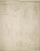
Distinctive Features:Compiled and signed by a Special Committee on the Aden Defences formed of Engineers William Jacob and C.W. Grant, Bombay 11th September 1843.Contains five plans lettered for reference with corresponding sections and measurements reported.Inscriptions:Bottom right: ‘True Copy J.A. Curtis Lieut. Exect. Eng. Aden’.5 plans on 1 sheetMaterials:Pen and ink with wash on paperDimensions:822 x 1300 mm
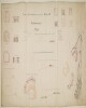
Distinctive Features:Compiled and signed by a Special Committee on the Aden Defences formed of Engineers Lieutenant Colonel C.W. Grant and Major Artillery William Jacob, Bombay 23rd April 1844.Contains plan showing position of Lower Tower and batteries with traversing platforms on the summit of Seera Island. Plans of vaults, first floor plan, longitudinal sections and front elevations are also included. Numbered for reference with key provided.Labels:On verso, upper right: ‘Duplicate ADEN Sea Defences proposed on Seera Island. No. 35’.1 sheetMaterials:Pen and ink with wash on paperDimensions:732 x 1288 mm