Reproduction of a black-ink illustration of a landscape, with a plain in the foreground and mountains in the background. Tents, forming part of the Commissariat Camp can be seen to the right of the illustration. Buildings comprising the village of Musemir [Al Musaymīr] can be seen towards the centre of the illustration. Some features of the illustration, including mountain peaks, Musemir and the Commissariat Camp, are annotated.1 illustrationDimensions:210 x 300 mm.
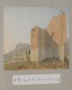
Genre/Subject Matter:This panoramic landscape view of a scene near Bushire [Būshehr] shows a flat plain with mountains in the background at left. A camp of white tents of varying sizes takes up the foreground at left; behind them a plantation of palms extend beyond the scene at far left. As the sun is setting at right, it seems likely that the view is roughly southwards.Temporal Context:Although the image dates from the Ouseley embassy 1810–12, the adjacent caption/description likely dates from c. 1880 and was written by later owner of the album, F. G. McCutcheon.Inscriptions:Recto:Lower right corner, in pencil: ‘27’Verso:Upper left, in pencil: ‘The Camp at Dalkie [Daliki] on the Road from Bushire to Shiraz’Adjacent inscription: ’27. Dalkee (one stage from Burazjoon) – The camp at Dalkee, a station near Bushire on the route from Bushire to Shiraz. There are sulphur springs in the neighbourhood.’ ‘Murray’s Guide p. 463.’1 watercolour drawing on paperDimensions:114 x 505 mmMaterials:Watercolour on paperCondition:Light surface dirt coats the recto and verso, with staining along all edges, particularly at right. The central fold is particularly stained and delicate, with signs of previous remedial work.
Reproduction of a black-and-white illustration depicting the view across a mountainous landscape. The Mafalis [Al Mafālīs] referred to in the title is a village, and is not obviously visible in the illustration.1 illustrationDimensions:150 x 250 mm.
Reproduction of an illustration of the port of Makalla [Al-Mukallā], as seen from the seaward side. The map is signed Lieutenant A L Paris, of the Royal Engineers, and dated 14 July 1902. A number of key buildings and other sites in the town (forts, towers, landing place) are highlighted.1 illustrationDimensions:250 x 330 mm.
Genre/Subject Matter:View of the ‘North Pass’, or Baab el Yemen, at Aden. This probably depicts a pass between the main British settlement at Crater and Khormakser. “Inside” may refer to the location the drawing depicts, or to the fact that it depicts the south side of the pass, i.e. within the British-controlled area.A path winds from centre foreground into a steep gulley; several barely sketched-in figures appear to walk along it. In the background at upper centre a bridge, viaduct or aqueduct is visible. At the top of the ridge at upper right a rectangular shape may indicate a man-made structure that leads down to the structure at centre.Inscriptions:Recto, in pencil, along lower edge: 'The North Pass of Aden or Baab el Yemen. “Inside”'Verso, in pencil, along upper edge: ‘WD3475’Temporal Context:This sketch was probably made between January 1939, when Stafford Bettesworth Haines seized Aden, and 1854, when he was recalled to Bombay to face embezzlement and fraud charges, during which time Haines administered Aden.1 pencil drawing on paperDimensions:128 x 185 mmMaterials:Pencil on paperCondition:Light surface dirt coats the recto and verso, but otherwise the paper is in good condition. A large stain in the upper-right corner is of unknown origin.
Genre/Subject MatterThis pencil sketch on paper depicts a man reclining against a pillow on a chaise-longue while reading. It is drawn in the style of a caricature, which is in keeping with other figural sketches in this volume and, more broadly, in the related files Mss Eur F140/232 and Mss Eur F140/233, which, together with this volume, complete the trio of journals created by Jeffrey C. Amherst.The man depicted is likely Captain Chamberlain, who Amherst cites as being ‘in command’ of B & D Companies upon his arrival at Aden on 30 November 1870. He is wearing at least one brace and holding the papers he is reading above his torso.The latter part of the inscription – ‘Marshag’ – refers to Ras Marshag, a promontory to the south of the Crater, upon which a lighthouse (built in 1861 to facilitate the navigation of increasing numbers of steamers passing through) was situated as well as the quarters for a detachment of infantry.InscriptionsUpper left corner: ‘Capt C at Marshag May 22nd 71’Temporal ContextThe drawing was made during the period Amherst was based at Aden, between 30 November 1870 and 1871/1872; on 5 February 1871, Amherst notes that he was in command of D Company and that he was based at the Isthmus Position, where two companies of British and two companies of Native Infantry were regularly based according to an 1877 publication (F. M. Hunter, An Account of the British Settlement at Aden, (London: Trübner & Co., 1877)). It seems Amherst moved about frequently between Crater, Isthmus, Ras Marshag and elsewhere during his time at Aden.1 drawing; pencil on paper, pasted into volumeDimensions:107 x 182 mm [landscape]Materials:Pencil on paperCondition:The paper is slightly foxed, but otherwise in good condition with adhesive still sturdy.Foliation:The image has been assigned a sequential number, 4, which is written in pencil in the lower right corner of the page onto which the image is pasted.
Genre/Subject Matter:Maritime view in the straits of Babelmandel [Bab-el-Mandeb]. A steamer is visible at left.Temporal context:This drawing was likely made during Henry Yule’s return journey to India with his new wife, Anna Maria White, in 1844.Inscriptions:Recto:Lower left, pen and ink: ‘Babelmandel Jany 1844’Upper right, ink stamp: ‘35’Verso:Centre, ink stamp: ‘India Office Library 12 Dec 1919’Upper right, pencil: ‘36’1 watercolour and ink drawing on watercolour paperDimensions:177 x 254 mmMaterials:Watercolour and pen on watercolour paperCondition:Thick surface dirt throughout and on recto with staining originating from adhesive on upper edge.
Reproduction of an illustration in black ink showing a panoramic view of the mountainous landscape west of the Wali Hassan shrine, in the direction of the town of Ad Dubiyat [Aḑ Ḑubayyāt]. Various hills, mountain peaks and other features are annotated with their transliterated names. Compass bearings are also given on some annotations.1 illustrationDimensions:250 x 520 mm.
Reproduction of a black-and-white illustration of a mountainous landscape, looking west towards Turkish territory from a pass at the head of the Wadi Hilhal. The map is annotated with various features, such as mountain peaks, valleys, hills and villages. The illustration is signed Major A Crawford and dated 7 May 1903. A note below the illustration states that it was produced from a hill approximately half a mile south east of the pass, and approximately 600 feet above it. The note also states that the positions and names indicated on the map were indicated by a guide belonging to the Ahmadi tribe.1 illustrationDimensions:210 x 340 mm.
Black and white reproduction of an illustration showing a view of the coast at Balhaf [Balḩāf]. The illustration is signed Lieutenant A L Paris, Royal Engineers, and dated 13 July 1902. The remains of the village, ruins, a tower, and the valley leading into the interior, are highlighted on the illustration.1 illustrationDimensions:150 x 248 mm.
Lithograph of a drawing by Samuel Butcher. The drawing shows the town and fort of Girash, looking southwest, after emerging from Tang-i-Masjidu pass. In addition to the town and fort it shows hills, watercourses and roads. Also shown is a date plantation surrounded by Gar trees and water cisterns.1 drawingMaterials: Printed on paperDimensions: 211 x 276mm
Reproduction of a black-and-white illustration of a mountainous landscape, the Radfān Hills, as seen from Wali Ḩassan. Various peaks and other landforms are annotated. Some annotations indicate compass bearings. The map is signed by Major J K Tod.1 illustrationDimensions:250 x 295 mm.