"Photographer's description: Pictures taken during the Egyptian Revolution. Text in image: ثروة المبارك (صحيفة الجارديان) – ثروة مبارك 15 مليار دولار – ثروة سوزان 3-5 مليار دولار – ثروة جمال 17 مليار دولار- ثروة علاء 8 مليار دولار- مجموع الثروة تقريبا 50 مليار دولار – الدين الخارجى 33 مليار دولار- الدين المحلى 123 مليار دولار – اذا الشعب يوما أراد الحياة فلابد أن يستجيب البقرمع الاعتذار لأبى القاسم الشابى .Translation of Text in image: Fortune of the Mubāraks (The Guardian Newspaper): -Mubārak 15 Billion Dollars -Suzanne 3-5 Billion Dollars -Gamal 17 Billion Dollars -Alaa 8 Billion Dollars Total of 50 Billion Dollars External debt: 30 Billion Dollars Local debt: 123 Billion Dollars . If one day the people want to live then the cows must obey with apologies to Abi Kassem Al Shaby."
"Photographer's description: Pictures taken during the Egyptian Revolution. Text in image: (ارحل).Get Out; Get Out; Out. رمسيس Ramses. Translation of Text in image: Leave."
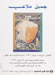
https://libraries.aub.edu.lb/xtf/data/posters/ark86073b3b33p/thumb.jpgprinted on paper : 41 x 30 cmJamil Malaeb : "Painting Exhibition"Painting reproduced on poster by G. Molaeb. Launching 7 April 1993, continues till 28 April 1993. Ajial for Plastic Arts, Abdel Aziz street. Beirut. Nakhal for printing and advertising.
"Photographer's description: Pictures taken during the Egyptian Revolution. Text in image: عيش يتاكل - حرية - كرامة - انسانية. Translation of Text in image: Bread(edible)- Liberty- Human Dignity. Text in image on reverse: DEMOCRACY."
"Demonstrators in the crowd on the groud are making peace signs. Photographer's description: Pictures taken during the Egyptian Revolution. Text in image: مطالبنا: اسقاط الرئيس- حل مجلس الشعب و الشورى الزورين- انهاء حالة الطوارئ فورا- تشكيل حكومة وحدة وطنية انتقالية دستورية لاجراء انتخابات رئاسية- محاكمات فورية للمسئولين عن قتل شهداء الثورة- محاكمات عاجلة للفاسدين سارقى ثروات البلد. Translation of Text in image: Our Demands: Bring down the the President - Dissolutuon of the fraudful parliament and the Shurra Council - end the state of emergency immediately - to form a government of national unity and constitutional transition for presidential elections - Instant trials for those responsible for killing of the martyrs of the revolution - speedy trials for the corrupt thieves’ that stole the country's wealth."
"Photographer's description: Pictures taken during the Egyptian Revolution. Text in image: مبارك SHIFT DEL. Translation of Text in image: Mubārak SHIFT DEL."
Genre/Subject Matter:This photograph shows four men and a camel standing in a flat, stony area. Behind them tall hills rise. The title suggests that one of the men is Sharif Yahya, ‘a son of Sharif Ahmed, whose father was the famous Grand-Sharif Abdulmutalib [bin Ghalib (1880–82)], who died in 1886’.The camel’s reigns are held by Yahya’s slave; to his left, is Yahya himself, in his riding habit, while the two men on the far left are sharifs of a lower rank.The sharif on the left wears a white
thawbunderneath a dark-coloured outer robe. At his waist a scimitar or long
janbiya– the curved dagger that is traditionally worn at the waist in countries on the Arabian Peninsula – is held in place by a belt. The sharif second from left wears white trousers, a dark-coloured outer robe and striped shirt with a
janbiyaat his waist. Both men wear white keffiyehs held in place by dark-coloured agals and sandals. Each holds a stick in his right hand.Yahya and his slave both also wear keffiyehs held in place by dark-coloured agals but while Yahya’s is dark, his slave’s is white. Both men wear belts held up at the torso by decorated neck halters. Yahya holds a stick in his left hand; his slave holds a long-barrelled rifle upright by the upper barrel.The camel is shown bearing a ‘saddle cloth, richly embroidered with silver [thread], or
batāt’. Tassels hang from a decorative harness as well as from the saddle itself.The negative has had hand-work applied, causing it to take on a drawing-like quality in places.Inscriptions:Above image, on the right, in ink: ‘XVII’1 collotype printDimensions:185 x 241 mmFormat:Collotype print, pasted into volumeCondition:The print is in good condition with minor surface dirt and light abrasions throughout.Foliation:‘XVII’Process:Collotype
Genre/Subject Matter:This landscape view shows ‘the eastern part of valley of Muna (Mina)’ from an elevated position, seven kilometres east of the Masjid al-Haram in Mecca. Muna (Mina) is a station of the hadj, where pilgrims camp out on the 8th, 11th, 12th (and some on the 13th) of
Dhul-Hijjah, as can be seen in this image.Right of centre, along the horizon, eight arches are set into a pale-coloured building. Otherwise no other permanent structures are evident, however, the rest of the flat plain that takes up the middle ground is dotted with many and varying tents, people, beasts of burden, such as horses, camels and donkeys. Small flocks of sheep or goats are visible in the foreground to the right of centre.A ridge of hills rises along the horizon, with the highest point to the right of centre.Arabic script written directly into the image has been erased subtly, but is visible upon close inspection in the lower left of the image as well as in the central sky area of the image.This is the second of two photographs taken from the same vantage point, which form a panoramic view over the valley. The first is X463/11.Inscriptions:Above image, on the right, in ink: ‘XI’Temporal Context:According to Durkje van der Wal in his publication
Christiaan Snouck Hurgronje: The First Western Photographer in Mecca, 1884-1885(Amsterdam : Manfred & Hanna Heiting Fund, Rijksmuseum, 2011, pp. 43-51), the photographs in this publication that pertain to the hadj (this image included) likely date to August 1888 since this was the period of the last hadj before February 1889, the date Christiaan Snouck Hurgronje received the final consignment of images.1 collotype printDimensions:186 x 243 mmFormat:Collotype print, pasted into volumeCondition:The print is in good condition with minor surface dirt and light abrasions throughout.Foliation:‘XI’Process:Collotype
Genre/Subject Matter:This landscape view shows ‘the western part of valley of Muna (Mina), which extends from west to east, during the annual gathering of pilgrims [the hadj]’ from an elevated position northeast of the Masjid al-Khayf in Muna, seven kilometres east of the Masjid al-Haram in Mecca. Muna (Mina) is a station of the hadj, where pilgrims camp out on the 8th, 11th, 12th (and some on the 13th) of
Dhul-Hijjah, as can be seen in this image.See Photo 174/9 for a comparative view from a similar vantage point but with a closer view of the Masjid al-Khayf, which here appears in the left of the background. The structure to the right of the iwan-like entryway, which appears damaged in the latter view, here appears intact. In the far middle ground at right two and three-storey structures can be seen. A ridge of hills rises along the horizon.The middle ground is occupied by tents, while in the foreground there are a wide variety of beasts of burden, such as horses, camels and donkeys, standing, tethered or couched.The negative has had hand-work applied, creating a drawing-like quality, particularly in the background, where the original plate may have been over-exposed.Arabic script written directly into the image has been erased subtly, but is visible upon close inspection in the lower right of the image as well as in the central sky area of the image.This is the first of two photographs taken from the same vantage point, which form a panoramic view over the valley. The second is X463/12.Inscriptions:Above image, on the right, in ink: ‘X’Temporal Context:According to Durkje van der Wal in his publication
Christiaan Snouck Hurgronje: The First Western Photographer in Mecca, 1884-1885(Amsterdam : Manfred & Hanna Heiting Fund, Rijksmuseum, 2011, pp. 43-51), the photographs in this publication that pertain to the hadj (this image included) likely date to August 1888 since this was the period of the last hadj before February 1889, the date Christiaan Snouck Hurgronje received the final consignment of images.1 collotype printDimensions:185 x 237 mmFormat:Collotype print, pasted into volumeCondition:The print is in good condition with minor surface dirt and light abrasions throughout.Foliation:‘X’Process:Collotype
Distinctive Features:An outline map entitled 'Chart showing the Pearl Banks along Arabian Shore of the Persian Gulf between Ras Tanura and Dabai' issued as an enclosure to Part II of Volume I of the ‘Persian Gulf Gazetteer'. Shows the southern coast of the Persian Gulf between Ras Tanura and Dabai [Dubai] with the location of the pearl banks indicated. Each of the pearl banks is marked with a number.Bottom left-hand corner below neat line: ‘Reg. No. 1605 E., 14.-V.-225’.1 mapDimensions:361 x 585 mm, on sheet 457 x 683 mm
This maps, dawn in colour, indicates the territory of Kuwait, and its major settlements in English and Arabic.1 MapMaterials: Bromide hand coloured in watercolourDimensions: 410 x 340 mm
Map of Kuwait produced (according to a letter on folio 409 of IOR/L/PS/12/3811) by the Anglo-Persian Oil Company (APOC).The map shows main settlements (with place names in both English and Arabic), and gives some indication of relief. The boundaries of Kuwait are shown by means of a line of thick dashes and dots, and are explained in the letter on folio 409.1 mapMaterials: printed on paper.Dimensions: 320 x 400mm, on sheet 330 x 410mm.
Genre/Subject MatterThis image shows a view over the city of Mecca from an elevated position east of the Masjid al-Haram, or Grand Mosque. Parts of the city due south of the mosque are visible in the middle ground. (Compare, for example, X463/1.)In the left of the image on the horizon, the fortified structure known as ‘Jiyad Castle’ is visible. The large building on the right is identified in the title as the ‘Hamidiyah’, a two-storey building which is described in the title of a photograph in Christiaan Snouck Hurgronje’s earlier publication of 1888,
Bilder-Atlas zu Mekka(1781.b.6/4) as a government building built by Governor General Othman Pascha. This was likely constructed during the reign of the Ottoman Sultan Abdulhamid II (1876–1909) and was therefore relatively new.The two-storey pale-coloured building to the left of this is identified as the ‘printing house’ (cf. X463/6).Derelict or semi-derelict structures make up the foreground while hills rise in the background.This is the first of four photographs taken from the same vantage point, which form a panoramic view over the city of Mecca. The second, third and fourth are X463/3, X463/4 and X463/5 respectively.InscriptionsAbove image, on the right, in ink: ‘II’Lower centre and upper centre: Illegible, partially erased Arabic script1 collotype printDimensions:190 x 243 mmFormat:Collotype print, pasted into volumeCondition:The print is in good condition with minor surface dirt and light abrasions, though no surface losses in the lower right of centre.Foliation:‘II’Process:Collotype
Genre/Subject Matter:This landscape view shows an expansive camping ground near Mecca at a place called Sarif (Saref or ‘èn-Nawwārijjeh’, according to Snouck Hurgronje), described as ‘the grave of our lady Maymūna [the last of nine wives married to the prophet Mohammed] and camp of the Meccan pilgrims who travelled there’. Snouck Hurgonje, in the second volume of his publication
Mekkadescribes the place, as well as the festival of ‘Sittanā Mèjmūnah’ in detail.Much of the foreground and middle ground is littered with tents of varying shapes and sizes. Several low-lying hills are evident in the background, while a pathway snaking from left through the centre into the distance is described as ‘the way to Mecca’ in the title.Tradition relates that she requested to be buried at this location, where she married Mohammed.This photograph is described as a ‘third view’, however, it does not appear to have been taken from the same vantage point as the two previous photographs.Inscriptions:Above image, on the right, in ink: ‘IXa’Temporal Context:According to Durkje van der Wal in his publication
Christiaan Snouck Hurgronje: The First Western Photographer in Mecca, 1884-1885(Amsterdam : Manfred & Hanna Heiting Fund, Rijksmuseum, 2011, pp. 43-51), the photographs in this publication that pertain to the hadj (this image included) likely date to August 1888 since this was the period of the last hadj before February 1889, the date Christiaan Snouck Hurgronje received the final consignment of images.1 collotype printDimensions:103 x 145 mmFormat:Collotype print, pasted into volumeCondition:The print is in good condition with minor surface dirt and light abrasions throughout.Foliation:‘IXa’Process:Collotype
Genre/Subject MatterThis image shows the city of Mecca from an elevated position due east of the Masjid al-Haram, or Grand Mosque. Parts of the city due north of the Masjid al-Haram are visible in the middleground.A large two-storey, fortified building is situated immediately below the horizon on the foothills of the northern ridge, to the right of the image. The northernmost part of the Masjid al-Haram is visible just below the central point on the left edge of the image.Derelict or semi-derelict structures make up the lower left foreground while a long ridge is visible in the background.This is the third of four photographs taken from the same vantage point, which form a panoramic view over the city of Mecca. The first, second and fourth are X463/2, X463/3 and X463/5 respectively.The negative has had hand-work applied, creating a drawing-like quality along the left-hand edge.InscriptionsAbove image, on the right, in ink: ‘IV’Lower centre and upper centre: illegible, partially erased Arabic script1 collotype printDimensions:188 x 245 mmFormat:Collotype print, pasted into volumeCondition:The print is in good condition with minor surface dirt and light abrasions, though no surface losses in the lower right of centre.Foliation:‘IV’Process:Collotype
Genre/Subject Matter:This landscape view shows an expansive camping ground near Mecca at a place called Sarif (Saref or ‘èn-Nawwārijjeh’, according to Snouck Hurgronje), described as ‘the grave of our lady Maymūna [the last of nine wives married to the prophet Mohammed] and camp of the Meccan pilgrims who travelled there’. Snouck Hurgonje, in the second volume of his publication
Mekkadescribes the place, as well as the festival of ‘Sittanā Mèjmūnah’ in detail.Much of the foreground, middle ground and background is littered with tents of varying shapes and sizes. In the foreground bushes can be seen and in the middle ground and background pilgrims are grouped together. A ridge of hills rises to the left and extends into the far distance on the right along the horizon.Tradition relates that she requested to be buried at this location, where she married Mohammed. A group of pilgrims form a circle to the right of the centre of the image. At centre, the camera has captured the movement of pilgrims walking.The negative has had hand-work applied, creating a drawing-like quality in places, particularly in the background.This is the second of two photographs taken from the same vantage point, which form a panoramic view over the camp. The first is X463/7.Inscriptions:Above image, on the right, in ink: ‘VIII’Temporal Context:According to Durkje van der Wal in his publication
Christiaan Snouck Hurgronje: The First Western Photographer in Mecca, 1884-1885(Amsterdam : Manfred & Hanna Heiting Fund, Rijksmuseum, 2011, pp. 43-51), the photographs in this publication that pertain to the hadj (this image included) likely date to August 1888 since this was the period of the last hadj before February 1889, the date Christiaan Snouck Hurgronje received the final consignment of images.1 collotype printDimensions:188 x 244 mmFormat:Collotype print, pasted into volumeCondition:The print is in good condition with minor surface dirt and light abrasions throughout.Foliation:‘VIII’Process:Collotype
Genre/Subject MatterThis image shows the Caaba and Sanctuary at Mecca from an elevated position due east of the Masjid al-Haram, or Grand Mosque. Parts of the northwest and southwest of the city of Mecca are visible in the middleground. (Compare, for example, ‘Picture of the City of Mecca the Great’ Photo 174/3 from almost the same vantage point.)Due to the relatively slow shutter speed used by the photographer, the movement of the pilgrims performing
tawaf– the ritual of circumambulation of the Caaba seven times in a counter-clockwise direction during the hadj or umrah, starting from the black stone – is captured here as indistinct blurring of the figures closest to the Caaba on the left. There is a range of activity occurring through the mostly empty expanse around the Caaba. White, straight lines to the right and left of the Caaba as well as some activity near the cloisters on the right may indicate some form of construction work underway.A large two-storey building is situated immediately below the horizon on the foothills of the northern ridge.In the immediate foreground a wall or parapet is out of focus. Derelict or semi-derelict structures make up the lower left foreground while hills rise in the background.This is the second of four photographs taken from the same vantage point, which form a panoramic view over the city of Mecca. The first, third and fourth are X463/2, X463/4 and X463/5 respectively.The negative has had hand-work applied, creating a drawing-like quality.InscriptionsAbove image, on the right, in ink: ‘III’Lower centre and upper centre: Illegible, partially erased Arabic script1 collotype printDimensions:186 x 240 mmFormat:Collotype print, pasted into volumeCondition:The print is in good condition with minor surface dirt and light abrasions, though no surface losses in the lower right of centre.Foliation:‘III’Process:Collotype
Genre/Subject MatterThis street-view shows the front entrance of a pale-coloured building in Mecca described as the Printers. The title suggests that it had been ‘built in recent years’. The style of the building is clearly Ottoman and is similar to the Hamidiyya, which was built close by during the reign of Sultan Abdulhamid II (1876–1909).The pale-coloured building at left, of which only the corner can be seen is almost certainly the Hamidiyya, as the two buildings were located adjacent to one another, as can clearly be seen in X463/2.Notable features include a plaque above the door featuring Arabic script, a decorative lamp on the right hand corner of the building and a series of rainwater spouts to compensate for what may be a flat roof.In front of the build two benches, made of naturally bent wood as well as another structure are unoccupied, but nearer to the camera several men sit or stand near a series of benches in front to of a building on the right, some beneath an awning, which may point to the presence of a café or some other informal meeting place.To the right of these men, a group of four boys stand and look towards the camera. A further awning, out of focus due to its proximity to the camera, is evident in the upper right corner of the image.In the left foreground three figures in motion are captured. Though two of their faces have been roughly re-inscribed into the negative, adding to the ghost-like quality of the figures, it is clear the one furthest from the camera is a woman wearing a headscarf while the figure closest to the camera is a man wearing a turban.Behind the two-storey Printers one taller building in a style more common in Mekka can clearly be seen, as well as a large two-storey
rawashin.Aside from merely the faces of the figures, the negative has had hand-work applied, creating a drawing-like quality in places.InscriptionsAbove image, on the right, in ink: ‘VI’1 collotype printDimensions:165 x 235 mmFormat:Collotype print, pasted into volumeCondition:The print is in good condition with minor surface dirt and light abrasions, though no surface losses in the lower right of centre.Foliation:‘VI’Process:Collotype
This map is enclosed in a printed copy of the Anglo-Ottoman Convention of 1914. It depicts the line of demarcation of the boundary determined to separate the Yemen from the territory of the nine cantons of Aden (shown in blue). Also included is an enlarged inset map of the Shekh Sa'id [Ra’s Shaykh Sa‘īd] peninsula.The map's borders are lettered and numbered. Areas on the map are marked with Roman numerals and listed in a table of references. Another table provides a key to symbols and abbreviations. Place names and symbol and abbreviation references are printed in English and Arabic. As well as boundaries the map indicates hydrology, settlements, cultivation and roads. Relief is shown by contours and spot heights.This map is sheet four of four. Also included is an index to adjoining sheets and a note on the survey's sources.Small printed text near below the map states that it was surveyed by the Anglo-Turkish Boundary Commission, under Colonel Robert Alexander Wahab and Colonel Mustapha Remzi Bey, and printed at the Ordnance Survey Office, Southampton, 1914. The map also states the names of the British and Ottoman signatories of the Anglo-Ottoman Convention: E Grey [Edward Grey, Secretary of State for Foreign Affairs] and I Hakky [Ibrahim Hakki Pasha, Ottoman representative].1 map on 4 sheetsMaterials: Printed on paper.Dimensions: 935 x 621mm, on sheet 1081 x 689mm.