Genre/Subject Matter:View of the walls of a fort on Hormuz Island, perhaps the Fort of Our Lady of the Conception, also known as the Portuguese Castle, the construction of which was completed by the Portuguese after conquering the island in 1515.Two men stand in front of the crumbling walls, one immediately right of centre and one at far right, perhaps for the purpose of providing a scale.Inscriptions:Ink, below image: 'Exterior of Fort, Hormuz, showing mouldering walls.'1 b&w silver gelatin printDimensions:145 x 200 mmCondition:The print is in good condition, though the mounting paper is heavily foxed and crumblingFoliation:‘12’Process:Silver gelatin
Imprint:Published by James Horsburgh, Hydrographer to the East India Company.Distinctive Features:Relief shown by shading. Depth shown by soundings.Nautical chart of the northern shores of the Persian Gulf showing the coastline east of Shatt al-Arab to Bushire [Bushehr] compiled from the surveys carried out by the Bombay Marine’s officers between 1820 and 1829.Shows sandbanks and rock hazards; location of ruins and old entrance of Indian River marked.1 mapDimensions:504 x 599 mm, on sheet 565 x 777 mm
Imprint:General Staff India.Distinctive Features:Sketch map issued as an ‘Appendix B (1) Serial No. 12 D
2’ to illustrate British military operations on the Euphrates River from 26 June to 25
July 1915. Shows swamps and inundated fields with position for safe landing
marked.Marked ‘For Official Use Only’.In the left-hand corner: ‘S.D.O. No. 1356, September,
1915’.1 mapDimensions:200 x 330
mm
Oblique photograph taken in the course of an aerial reconnaissance of the Qatar Peninsula on 11 October 1935 by Squadron Leader J H Dand, Air Headquarters, British Forces in Iraq, Hinaidi. There is a report on the reconnaissance at IOR/R/15/2/159, folios 18-20.Inscribed: 800 feet.1 black and white photographDimensions: 180 x 180 mm.Foliation: the folio number, 28, is written in pencil, enclosed in a circle, and appears below the photograph near the right edge of the recto side of the folio. A previous foliation number has been crossed out.
Oblique photograph taken in the course of an aerial reconnaissance of the Qatar Peninsula on 11 October 1935 by Squadron Leader J H Dand, Air Headquarters, British Forces in Iraq, Hinaidi. There is a report on the reconnaissance at IOR/R/15/2/159, folios 18-20.Inscribed: 800 feet.1 black and white photographDimensions: 180 x 180 mm.Foliation: the folio number, 27, is written in pencil, enclosed in a circle, and appears above the photograph near the right edge of the recto side of the folio. A previous foliation number has been crossed out.
Oblique photograph taken in the course of an aerial reconnaissance of the Qatar Peninsula on 11 October 1935 by Squadron Leader J H Dand, Air Headquarters, British Forces in Iraq, Hinaidi. There is a report on the reconnaissance at IOR/R/15/2/159, folios 18-20.Inscribed: 700 feet.1 black and white photographDimensions: 180 x 180 mm.Foliation: the folio number, 22, is written in pencil, enclosed in a circle, and appears below the photograph near the right edge of the recto side of the folio. A previous foliation number has been crossed out.
Oblique photograph taken in the course of an aerial reconnaissance of the Qatar Peninsula on 11 October 1935 by Squadron Leader J H Dand, Air Headquarters, British Forces in Iraq, Hinaidi. There is a report on the reconnaissance at IOR/R/15/2/159, folios 18-20.Inscribed: 800 feet.1 black and white photographDimensions: 180 x 180 mm.Foliation: the folio number, 26, is written in pencil, enclosed in a circle, and appears below the photograph near the right edge of the recto side of the folio. A previous foliation number has been crossed out.
Oblique photograph taken in the course of an aerial reconnaissance of the Qatar Peninsula on 11 October 1935 by Squadron Leader J H Dand, Air Headquarters, British Forces in Iraq, Hinaidi. There is a report on the reconnaissance at IOR/R/15/2/159, folios 18-20.Inscribed: 800 feet.1 black and white photographDimensions: 180 x 180 mm.Foliation: the folio number, 24, is written in pencil, enclosed in a circle, and appears below the photograph near the right edge of the recto side of the folio. A previous foliation number has been crossed out.Condition: the caption is faint and not entirely legible.
Oblique photograph taken in the course of an aerial reconnaissance of the Qatar Peninsula on 11 October 1935 by Squadron Leader J H Dand, Air Headquarters, British Forces in Iraq, Hinaidi. There is a report on the reconnaissance at IOR/R/15/2/159, folios 18-20.Inscribed: 800 feet.1 black and white photographDimensions: 180 x 180 mm.Foliation: the folio number, 23, is written in pencil, enclosed in a circle, and appears above the photograph near the right edge of the recto of the folio. A previous foliation number has been crossed out.
Oblique photograph taken in the course of an aerial reconnaissance of the Qatar Peninsula on 11 October 1935 by Squadron Leader J H Dand, Air Headquarters, British Forces in Iraq, Hinaidi. There is a report on the reconnaissance at IOR/R/15/2/159, folios 18-20.Inscribed: 800 feet.1 black and white photographDimensions: 180 x 180 mm.Foliation: the folio number, 25, is written in pencil, enclosed in a circle, and appears above the photograph near the right edge of the recto side of the folio. A previous foliation number has been crossed out.
"Photographer's description: over 1100 photos in Tahrir Square; Feb. 142011 to March 182011. Photographer's description: over 1100 photos in Tahrir Square; Feb. 142011. Text in image: Egypt's Today Is Better…Tomorrow Is The Best."
Map showing the area of Bahrain that the crude oil pipe line was proposed to traverse. The pipeline runs from the west coast of Bahrain between Kuraiya [Al Qurayyah] and Jasra [Al Jasrah] to the Bahrain Petroleum Company (BAPCO)'s refinery on the west coast near Nuwaidrat [An Nuwaydirāt].The pipeline is marked by two parallel ink lines and coloured red. Its direction is marked using longitute and latitude co-ordinates and distances in feet. Additional longitute and latitude markers are included near the village of Buri [Būrī] to show where the route had been revised.A legend includes a dotted line showing gardens, a dashed line showing roads and a longer dashed line showing the boundary of BAPCO's concession area.1 Map Sheet.Foliation: A pencil number enclosed in a circle is located in the top right hand corner of the recto of the folio.Materials: Parchment sheetDimensions: 440mm x 1010mm
Map showing the area of Bahrain that the crude oil pipe line was proposed to traverse. The pipeline runs from the west coast of Bahrain between Kuraiya [Al Qurayyah] and Jasra [Al Jasrah] to the Bahrain Petroleum Company (BAPCO)'s refinery on the west coast near Nuwaidrat [An Nuwaydirāt]. The pipeline is marked by two parallel ink lines and its direction is marked using longitute and latitude co-ordinates and distances in feet.A legend includes a dotted line showing gardens, a dashed line showing roads and a longer dashed line showing the boundary of BAPCO's concession area.1 Map Sheet.Foliation: A pencil number enclosed in a circle is located in the top right hand corner of the recto of the folio.Materials: Parchment sheetDimensions: 250mm x 1010mm
"Photographer's description: Pictures taken during the Egyptian Revolution. Text in image: (ارحل).Get Out; Get Out; Out. رمسيس Ramses. Translation of Text in image: Leave."
The map shows Mesopotamia and the Turco-Persian frontier with the main rivers and cities. A red line indicates the principal pilgrim route from Hamadan, Persia, to Nejef.1 mapMaterials: Printed on paper.Dimensions: 330 x 200mm.
The map shows the Shatt-ul-Arab [Shatt al-Arab] waterway with the frontier line between Turkey and Persia show in red ink.1 mapMaterials: Printed on paper.Dimensions: 330 x 200mm.
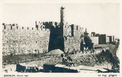
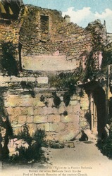
https://libraries.aub.edu.lb/xtf/data/postcards/ark86073b37w29/thumb.jpg1 photomechanical print (postcards) : black and white ; 9 x 14 cm.Title from item.Captioned in English and Hebrew.Handwriten note in Arabic on verso dated July 24, 1931.
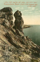
https://libraries.aub.edu.lb/xtf/data/postcards/ark86073b3q592/thumb.jpg1 photomechanical print (postcard) : color ; 9 x 14 cm.Title from item.Captioned in English, French and German.
"Photographer's description: Pictures taken during the Egyptian Revolution. Text in image: عيش يتاكل - حرية - كرامة - انسانية. Translation of Text in image: Bread(edible)- Liberty- Human Dignity. Text in image on reverse: DEMOCRACY."
"Photographer's description: Pictures taken during the Egyptian Revolution. Text in image: مبارك SHIFT DEL. Translation of Text in image: Mubārak SHIFT DEL."
https://libraries.aub.edu.lb/xtf/data/postcards/ark86073b3501b/thumb.jpg1 photomechanical print (postcard) : color ; 9 x 14 cm.Title from item.Captioned in English and Hebrew.
Genre/Subject Matter:View of a steamship, ‘British Sailor’, moored alongside a quay at Mina [Mina Salman Port], Bahrain.Inscriptions:Below image, in pen: 'British Sailor at Mina'Below image, in pencil: ‘506’1 b&w silver gelatin printDimensions:54 x 78 mmCondition:The image is in good condition.Foliation:‘506’Process:Silver gelatin print
Genre/Subject Matter:View from the stern of a steamship, ‘British Sailor’, at sail.Inscriptions:Below image, in pen: 'British Sailor'Below image, in pencil: ‘507’1 b&w silver gelatin printDimensions:54 x 78 mmCondition:The image is in good condition.Foliation:‘507’Process:Silver gelatin print
Genre/Subject MatterThis view of Bushire (Bushehr), from an elevated position looking south, is taken from the roof of the offices of Gray, Paul and Co. (sister firm to Gray, MacKenzie and Company), a company that acted as shipping agent for British India steamers between India and Europe, via the Gulf ports.A number of buildings are seen in the photograph, though relative degradation of the image obscures much of the background and horizon area. A building under construction extends from the lower left of the image to the centre. Immediately behind this, the terrace of a flat-roofed building is fenced off. Next to the building under construction, and immediately below the centre of the image, bricks can be seen stacked high against the wall of an adjacent building.In the far right of the image, towards the horizon, a domed roof can clearly be seen amongst the flat-roofed buildings. Although the dome is windowless, a smaller dome with openings to allow light to filter through sits atop it. This is possibly a bath house.InscriptionsLower right, in pencil, alongside image: ‘83’Below image: ‘The Town looking South from Gray. Paul's Office. 23. Feb. 1902’1 photographic printDimensions:109 x 155 mm [landscape]Format:Materials:Condition:The image is considerably faded throughout, with surface losses along the upper edge.Foliation:'83'Process:
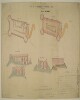
Distinctive Features:Space in the first line of title left blank.Includes ground plan and ‘PLAN OF TERRE PLEIN’ of Ras-Morbat Fort with corresponding longitudinal sections and elevations. Lettered for reference with a key in the bottom right-hand corner. Measurements reported.Inscriptions:On recto, bottom left-hand corner: ‘Isthmus Office July 15th 1846 Drawn by F. Welsh’.‘Copied in the Chief Engrs. Office Bombay 26th September 1846’.On recto, bottom center: ‘/Signed/ J. Kilner Captain Executive Engineer Aden’.On verso, bottom left-hand corner with bleed-through into the recto:‘In Bombay Secret Lre. No. 113 of 1846 Recd. via Southampton 10th Novr. 1846 Aden Fortifications’.1 sheetMaterials:Pen and ink with wash on tracing paperDimensions:695 x 1022 mm
Genre/Subject MatterGeneral view from the outskirts of the town (likely present-day Mutrah) to the harbour and promontory fort, from an elevated position, looking north-northeast. The area of the town and coastline visible in the distant middleground is the part of the town featured in the previous image (Photo 430/8/1). A ship can be seen emerging from behind the promontory right of centre on the horizon near Fort Al-Mirani.While those distant buildings are clearly several-storeyed white-washed buildings, the dwellings in the fore- and middleground are, for the most part, tents and other temporary structures. Overlooking these, on the western ridge a fortified tower can be seen in the far left of the image.A group of figures stands under a single tree in the foreground.InscriptionsUpper right, in pen, on image: ‘p. 3’; alongside image, in pencil: ‘b’Lower right, in pencil, alongside image: ‘2’Below image: 'The Town looking North. 31 Oct. 1900'1 photographic printDimensions:75 x 104 mm [landscape]Format:Materials:Condition:The image is faded throughout with surface losses in the upper left corner. White smeared spot staining in the right hand side of the image and in the lower right-hand corner originate in the printing phase.Foliation:'p 3'; 'b'; '2'Process:
Genre/Subject MatterGeneral view over the town out towards the harbour, from the south-west, looking north-east. Several-storeyed white-washed buildings can be seen in the fore- and middleground. To the far left, two apparently fortified towers can be seen on the foothills of the ridge at left; this is likely to be Fort Al-Mirani.In the bay, two large ships and two smaller boats, possibly dhows, can be seen.InscriptionsUpper right, in pen, on image: ‘p. 1’; alongside image, in pencil: ‘a’Lower right, in pencil, alongside image: ‘1’Below image: 'Town and Bay. 31rst Oct. 1900'1 photographic printDimensions:77 x 100 mm [landscape]Format:Materials:Condition:The image is considerably faded. There are surface losses in the left-hand lower corner and there is surface staining and residue throughout.Considerable fading.Foliation:‘p. 1’; ‘a’; ‘1’Process:
Genre/Subject MatterThis view of the Al-Jalali Fort at the south-eastern end of the Bay of Muscat was likely photographed from the roof of the British Consulate, situated along the shoreline adjacent to it (see also Photo 430/8/3).InscriptionsUpper right, in pen, on image: 'p. 8'; alongside image, in pencil: ‘b’Lower right, in pencil, alongside image: ‘4’Below image: ‘Old Portuguese Fort (1550). 31. Oct. 1900’1 photographic printDimensions:77 x 100 mm [landscape]Format:Materials:Condition:The image is considerably faded throughout. Large white spot staining in the upper left of the image probably originate in the printing phase.Foliation:'p. 8'; 'b'; '4'Process:
Genre/Subject MatterView from the shoreline of the British Consulate at Muscat, looking due west.The consulate is a pale-stoned, two or three-storeyed building built along the quays. Two gas lamps can be seen along the quay in front of the building and a single mashrabiyya (a form of enclosed balcony) breaks up the centre of the facade.Above the consulate a flagpole carries a flag. Figures can be seen sitting on the quay to the far left of the image. Several small boats are tied up along the shoreline.InscriptionsUpper right, in pen, on image: [illegible]; alongside image, in pencil: ‘a’Lower right, in pencil, alongside image: ‘3’Below image: ‘British Consulate. 31. Oct. 1900’1 photographic printDimensions:77 x 102 mm [landscape]Format:Materials:Condition:The image is considerably faded throughout with surface losses along the right-hand edge, lower left corner and 13 mm from left, 40 mm from lower edge. White smeared spot staining in the left-hand side of the image originate in the printing phase.Foliation:'c'; '3'Process:
Genre/Subject MatterThis scene, taken from an elevated position looking southwards towards a bay, shows the village of Sidāb, approximately 3 km south of the Bay of Muscat.A well-trodden path or dried-up stream can be seen leading through the dwellings, the majority of which appear to be tents, in the direction of the shoreline. A few trees and bushes are discernible.InscriptionsUpper right, in pen, alongside image, in pencil: ‘d’Lower right, in pencil, alongside image: ‘6’Below image: ‘Sidap. Village. 31. Oct 1900’Along the left-hand side of the image, white, vertical: [illegible]1 photographic printDimensions:76 x 103 mm [landscape]Format:Materials:Condition:The image is considerably faded in the right of the image.Foliation:'d'; '6'Process:
Genre/Subject MatterThis view of the bay of Muscat from an elevated position in the east was likely photographed from Al-Jalali Fort. It shows the Al-Mirani fort at centre, along with the Sultan's Palace and a variety of other buildings lining the shore in the left middleground.Many small craft are visible in the middleground and foreground, while two boats are at anchor further out in the bay at the right of the image.InscriptionsUpper right, in pen, alongside image, in pencil: ‘c’Lower right, in pencil, alongside image: ‘5’Below image: ‘Sultan's Palace. 31. Oct 1900’1 photographic printDimensions:72 x 100 mm [landscape]Format:Materials:Condition:The image is faded at the left. There are some minor surface losses in the lower half of the image.Foliation:'c'; '5'Process:
Aerial photograph of a ruined settlement at Ambak [Nibāk], situated in a desert landscape on the frontier between Saudi Arabia and Qatar. The photograph was taken during a Royal Air Force reconnaissance flight on 14 October 1935. On the rear of the photograph is a red date stamp, marked ‘for official use only’, ‘Royal Air Force official, Crown Copyright Reserved’, and dated 16 October 1935.1 black and white photographDimensions:183 x 183 mm.
A map of the Eastern Persian Gulf that was compiled by Commander C G Constable and Lieutenant A W Stiffe in 1860. Corrections made by Commander F H Walter, HMS
Odinand Lieutenant H T Bowen, HMS
Alertin 1910. This version was printed by the Admiralty in 1929. Engraved by J & C Walker.The map has major settlements and relief marked, with water depth shown by soundings. An area of a proposed Royal Navy survey is marked in pink on the map.The map has detailed inserts showing the shore lines of Charak, Kais, Ras al-Khaimah, Hor [Khor] Fakkan, Abu Dhabi and Chiru.1 mapMaterials: Printed on paperDimensions: 1,100mm x 820mm
A map of the Eastern Persian Gulf that was compiled by Commander C G Constable and Lieutenant Arthur William Stiffe in 1860. Corrections made by Commander Frederic H Walter, HMS Odin and Lieutenant H T Bowen, HMS Alert in 1910. This version was printed by the Admiralty in 1934. Engraved by J & C Walker.The maps has major settlements and relief marked, with water depth shown by soundings. An area of a proposed Royal Navy survey is marked in pink on the map.The map has detailed inserts showing the shore lines of Charak, Kais, Ras al-Khaimah, Hor [Khor] Fakkan, Abu Dhabi and Chiru.1 mapMaterials: Printed on paperDimensions: 1,100mm x 820mm
Hydrographic Office map showing the Persian Gulf and Gulf of Oman, with a number of inset maps (including Doha and Abu Dhabi), and views of the coast and islands from the sea. Compiled from surveys by Captain John Michael Guy and Captain George Barnes Brucks, 1821-29, and by Commander Charles Golding Constable and Lieutenant ArthurWilliam Stiffe, 1860, with additions and corrections from surveys by Commander Henry Boyle Townshend Somerville 1903, Commander FH Walter, 1910, Lieutenant HT Bowen, 1910, and Commander Arthur Guy Norris Wyatt, Lieutenant-Commander DH Fryer and Commander A Day, HM Surveying ship
Ormonde, 1930-33.Soundings given in fathoms. Settlements marked, and some indication of relief.Map shows median line (in red); land frontiers and extensions to median line (red dotted line); 20 fathom line (in green); and 10 fathom line (green dotted line). This information is given in a legend at the top centre of the map.No scale given for main map; scale of insets varies.1 mapMaterials: printed on paper.Dimensions: 490 x 640mm, on sheet 520 x 700mm.