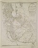
1. 'A New Map of the Empire of Persia from Monsr. D'Anville, First Geographer to the most Christian King, with Several Additions and Emendations' Contributor: Laurie & Whittle, Publishers and publishing (publisher)Jean Baptiste Bourgignon d'Anville (publisher) Date: 1794/1794 Language: English Geographic region: Persia Extent: 1 map sheet
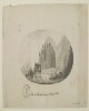
2. 'View of Muscat, entrance of Persian Gulph' Date: 1787/1787 Language: English Geographic region: Muscat Extent: 1 view
4. A map of Ancient Aegypt from Celarius. Creator: Cellarius, Andreas. Date: ca. 1750 Language: English Geographic region: Egypt; Africa
5. Aegypti Delta et Nili Ostia Creator: Cellarius, Christoph 1638-1707 Date: ca. 1750 Language: Latin Geographic region: Egypt; Africa
6. Africa, 1785 (Image 2 of 2) (Raster Image) Date: 201202 Geographic region: Africa129.30122453.016479-53.6349089.414992
7. Africa, 1795 (Raster Image) Date: 201202 Geographic region: Africa143.95762754.662494-51.894121-106.473090
8. Africa, 1797 (Raster Image) Date: 201201 Geographic region: Africa133.67160254.465561-53.071567-94.130562
9. Bahram Gur and Azadeh Date: mid 18th century Time period: Zand Medium: Oil on canvas Extent: 36 x 35 in. (91.4 x 88.9cm)
10. Books of the Torah Date: 1799 Language: Arabic Medium: manuscripts (document genre) Extent: 366 p.; 21.2 x 15.3 cm.
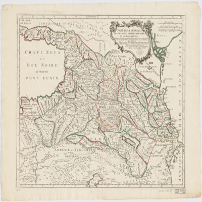
12. Carte de la Géorgie et des pays situés entre la mer Noire et la mer Caspiennedessinée en 1738 d'après les Cartes, Mémoires, Mesures et Observations des gens du Pays Creator: Santini, P. (المنشئ) Date: Date Issued: 1775 Language: FrenchGeorgian Geographic region: Place of Production: it, Italy, VeniceGeorgia (Republic)Armenia Extent: 1 map : hand col. ; 46 x 64 cm.