385. 'Map 2. Mesopotamia. Racial Divisions' Date: 1916/1916 Language: English Geographic region: Mesopotamia Extent: 1 map
386. 'MAP 20 MAP TO ILLUSTRATE THE ACTION OF BAIT ISA ON 17TH. & 18TH. APRIL 1916 AND THE ATTACK ON SANNAIYAT 22ND. APRIL 1916' Contributor: Ordnance Survey (publisher) Date: 1924/1924 Language: English Extent: 1 map
387. 'MAP 21 TO ILLUSTRATE OPERATIONS ON THE TIGRIS FRONT, MAY TO 12TH. DECEMBER, 1916.' Contributor: Ordnance Survey (publisher) Date: 1925/1925 Language: English Extent: 1 map
388. 'MAP 22 TO ILLUSTRATE OPERATIONS ON THE TIGRIS._13TH. DECEMBER 1916, TO 25TH. FEBRUARY 1917.' Contributor: Ordnance Survey (publisher) Date: 1925/1925 Language: English Extent: 1 map
389. 'MAP 23 MAP TO ILLUSTRATE OPERATIONS AGAINST THE HAI SALIENT AND THE DAHRA BEND POSITIONS, AND THE PASSAGE OF THE TIGRIS: 11TH. JANUARY-24TH. FEBRUARY, 1917.' Contributor: Ordnance Survey (publisher) Date: 1925/1925 Language: English Extent: 1 map
390. 'MAP 25. TO ILLUSTRATE OPERATIONS RESULTING IN THE CAPTURE OF BAGHDAD, on 11th. March, 1917.' Contributor: Ordnance Survey (publisher) Date: 1925/1925 Language: English Extent: 1 map
391. 'MAP 26 SKETCH MAP OF AREA NORTH OF BAGHDAD.' Contributor: Ordnance Survey (publisher) Date: 1925/1925 Language: English Extent: 1 map
392. 'MAP 27 TO ILLUSTRATE THE ACTION OF MUSHAHIDA. 14th. March, 1917.' Contributor: Ordnance Survey (publisher) Date: 1925/1925 Language: English Extent: 1 map
393. 'MAP 28 TO ILLUSTRATE THE FIRST ACTION OF THE JABAL HAMRIN. 25th. March, 1917.' Contributor: Ordnance Survey (publisher) Date: 1925/1925 Language: English Extent: 1 map
394. 'MAP 29 TO ILLUSTRATE THE AFFAIR OF DUQMA. 29th. March, 1917.' Contributor: Ordnance Survey (publisher) Date: 1925/1925 Language: English Extent: 1 map
395. 'Map 3. Mesopotamia' Date: 1916/1916 Language: English Geographic region: Mesopotamia Extent: 1 map
396. 'MAP 30 TO ILLUSTRATE THE OPERATIONS ABOUT THE KHALIS CANAL. 9th.-15th. April, 1917.' Contributor: Ordnance Survey (publisher) Date: 1925/1925 Language: English Extent: 1 map
397. 'MAP 32 TO ILLUSTRATE THE ACTION OF ISTABULAT. 21st. and 22nd. April, 1917.' Contributor: Ordnance Survey (publisher) Date: 1925/1925 Language: English Extent: 1 map
398. 'MAP 33 SKETCH MAP TO ILLUSTRATE THE ACTION OF ADHAIM. 30th. April, 1917.' Contributor: Ordnance Survey (publisher) Date: 1925/1925 Language: English Extent: 1 map
399. 'MAP 35. TO ILLUSTRATE OPERATIONS IN THE JABAL HAMRIN; OCTOBER AND DECEMBER, 1917.' Contributor: Ordnance Survey (publisher) Date: 1927/1927 Language: English Extent: 1 map
400. 'MAP 36 TO ILLUSTRATE THE ACTIONS AT DAUR ON THE 22ND. AND TIKRIT ON THE 5TH. NOVEMBER, 1917.' Contributor: Ordnance Survey (publisher) Date: 1927/1927 Language: English Extent: 1 map
401. 'MAP 37 TO ILLUSTRATE OPERATIONS ON THE EUPHRATES LINE. March, 1918.' Contributor: Ordnance Survey (publisher) Date: 1927/1927 Language: English Extent: 1 map
402. 'MAP 38 TO ILLUSTRATE THE ACTION OF KHAN BAGHDADI. 26th. March, 1918.' Contributor: Ordnance Survey (publisher) Date: 1927/1927 Language: English Extent: 1 map
403. 'MAP 39 TO ILLUSTRATE OPERATIONS IN THE KIFRI-KIRKUK AREA, APRIL AND MAY, 1918.' Contributor: Ordnance Survey (publisher) Date: 1927/1927 Language: English Extent: 1 map
404. 'MAP 40 TO ILLUSTRATE THE CAVALRY AFFAIR of the 27th. April, 1918, and THE ACTION OF TUZ KHURMATLI, 29th. April, 1918.' Contributor: Ordnance Survey (publisher) Date: 1927/1927 Language: English Extent: 1 map
405. 'MAP 41 SKELETON MAP TO ILLUSTRATE THE OPERATIONS OF "DUNSTERFORCE", 1918.' Contributor: Ordnance Survey (publisher) Date: 1927/1927 Language: English Extent: 1 map
406. 'MAP 42 TO ILLUSTRATE THE OPERATIONS AT BAKU. AUGUST-SEPTEMBER, 1918.' Contributor: Ordnance Survey (publisher) Date: 1927/1927 Language: English Extent: 1 map
407. 'MAP 43 TO ILLUSTRATE OPERATIONS ON THE TIGRIS. 18th.-30th. October, 1918.' Contributor: Ordnance Survey (publisher) Date: 1927/1927 Language: English Extent: 1 map
408. 'MAP 45 TO ILLUSTRATE THE BATTLE OF SHARQAT. 29th. October, 1918.' Contributor: Ordnance Survey (publisher) Date: 1927/1927 Language: English Extent: 1 map
409. ‘The several bays near Cape of Aden, on the Arabian coast, surveyed trigonometrically’ Contributor: J & C Walker, engravers (surveyor)Stafford Bettesworth Haines (surveyor)John Walker (surveyor) Date: 1839/1839 Language: English Geographic region: Aden Extent: 1 map sheet
410. 'PERSIAN GULF - PORT OF KUWEIT Surveyed by Lieutts. T.H.H. Hand, C.S. Hickman, E.J. Headlam, A.G. Bingham and W.K. Thyne, R.I.M., under the direction of Captain T.H. Heming, R.N., in charge of the Marine Survey of India, 1905' Date: 1906/1906 Language: English Extent: 1 map
412. 'PERSIAN GULF AND ADJACENT COUNTRIES' Date: 1908/1908 Language: English Geographic region: Persian Gulf Extent: 1 map
413. 'PERSIAN GULF AND ADJACENT COUNTRIES' Contributor: War Office, Topographical Section, General Staff (publisher) Date: 1908/1908 Language: English Geographic region: Persian Gulf Extent: 1 map
415. 'PERSIAN GULF AND ADJACENT COUNTRIES' Contributor: War Office, Topographical Section, General Staff (publisher) Date: 1911/1911 Language: English Extent: 1 map
416. 'PERSIAN GULF. KUWEIT HARBOUR AND APPROACHES' Contributor: Admiralty (publisher) Date: 1907/1911 Language: English Geographic region: KuweitPersian Gulf Extent: 1 map
418. ‘PERSIAN GULF: PLANS OF THE NORTH EAST COAST OF BAHRAIN ISLAND’ Contributor: Admiralty (publisher) Date: 1937/1937 Language: English Geographic region: Bahrain HarborKhor Kaliya Extent: 1 map
419. 'PERSIAN GULF: Sketch of APPROACHES TO KUWAIT HARBOUR AND SHATT AL ARAB' Date: 1902/1907 Language: English Extent: 1 map
420. 'Landing at Koweit.' Photographer: Unknown Date: 1903/1903 Language: English Extent: 1 b&w silver gelatin print
421. 'PLANS IN THE PERSIAN GULF. BAHREIN HARBOUR' Contributor: Admiralty (publisher) Date: 1903/1911 Language: English Geographic region: Persian GulfBahrein Extent: 1 map
422. ‘Winds and Currents in the PERSIAN GULF. BY Lieutenant Fergusson I.N.F.R.A.S. Draughtsman to the Indian Navy. Engraved by J.&C. Walker’ Contributor: J & C Walker, engravers (artist)John Walker (publisher)E.F.T. Fergusson (surveyor) Date: 1856/1856 Language: English Geographic region: Persian Gulf Extent: 12 maps
425. ‘COUNTRY SOUTH OF CHILAS. 43I. A/3 AND A/4.’ Date: 1935/1935 Language: English Extent: 1 photograph
426. 'EAST COAST OF ARABIA SHOWING SAUDI ARABIA-BAHRAIN PIPE LINE' Date: 1944/1944 Language: English Extent: 1 Map Sheet.
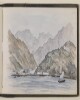
427. ‘Coast between Bookh & Shaum’ Date: 1825/1825 Language: English Geographic region: Shaum Extent: 1 watercolour view
428. ‘Coast from Raumps to Ras-al-Khyma’ Date: 1825/1825 Language: English Geographic region: Ras Al Khyma Extent: 1 watercolour view
429. ‘The Coast from Bushire to Basadore, in the Persian Gulf, Surveyed by Lieuts. G.B. Brucks & S.B. Haines, H.C. Marine 1828. Engraved by R. Bateman 43 Hart St. Bloomsbury’ Contributor: George Edward Brucks (surveyor)Stafford Bettesworth Haines (surveyor)Richard Bateman (artist)James Horsburgh (publisher) Date: 1831/1831 Language: English Geographic region: Persian Gulf Extent: 2 maps on 1 sheet
430. ‘Coast from Jezeerat Gunnum to Ras Sheik Munsoud’ Date: 1825/1825 Language: English Geographic region: Ras Moosendem Extent: 1 watercolour view
431. ‘Coast from Ras Sheik Munsood to Shaum’ Date: 1825/1825 Language: English Geographic region: Ras Moosendem Extent: 1 watercolour view
432. ‘Coast from Ras Moosendem to Perforated Rock’ Date: 1825/1825 Language: English Geographic region: Ras Moosendem Extent: 1 watercolour view
433. ‘Sartip Muhammed Hossein Khán, Bakhtiari.’ Date: 1882/1884 Language: EnglishPersian Extent: 1 photographic print
434. ‘Sarhang Hájji Ibrahim Khán, Commandant of the Bakhtiari Horse.’ Date: 1882/1884 Language: EnglishPersian Extent: 1 photographic print
435. ‘The Southern Flank of the Kuh-i-Gugird looking westwards.’ Date: 1945/1945 Language: English Geographic region: Kuh-i-Gugird Extent: 1 black and white photograph
436. 'R.I.M.S. Hardingeaccompanying Ships of the Royal East Indian Squadron.' Photographer: Unknown Date: 1903/1903 Language: English Extent: 1 b&w silver gelatin print
437. 'The Khalifa, halted at Ctesiphon' Photographer: Wilfrid Malleson Date: 1906/1906 Language: English Extent: 1 b&w silver gelatin print
438. 'The Turanian-speaking Peoples' Contributor: Admiralty War Staff, Naval Intelligence Division (publisher)Emery Walker Ltd, engravers and printers (publisher) Date: 1917/1917 Language: English Extent: 1 map
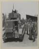
439. 'The Sultan interested in the tanks after the demonstration' by Sport & General Press Agency, London Contributor: Sport & General Press Agency Ltd (photographer) Date: 1938/1938 Language: English Extent: 1 loose b&w photographic print
440. 'Suez' by Kate Toynbee (fl. 1879-80) Date: 1880/1880 Language: English Extent: 1 watercolour drawing on watercolour paper, bound into volume
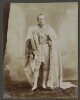
441. 'Saiyid Timur Bin Fasl, son of His Highness the Sultan of Muskat.' Photographer: Bourne and Shepherd Contributor: Bourne and Shepherd, photographers (photographer) Date: 1903/1903 Language: English Extent: 1 b&w albumen print
442. ‘Sharga in 6 ½ fathoms’ Date: 1825/1825 Language: English Geographic region: Sharga Extent: 1 watercolour view
443. ‘Sharjah. Proposed Additional Accommodation to Rest House’ Date: 1936/1936 Language: English Geographic region: Sharjah Extent: 1 map
446. 'THE MIDDLE EAST' Contributor: Ordnance Survey (publisher) Date: 1922/1922 Language: English Extent: 1 map
447. 'THE MIDDLE EAST.' Contributor: Ordnance Survey (publisher) Date: 1925/1925 Language: English Extent: 1 map
448. 'THE MIDDLE EAST.' Contributor: Ordnance Survey (publisher) Date: 1924/1924 Language: English Extent: 1 map
449. 'THE MIDDLE EAST.' Contributor: Ordnance Survey (publisher) Date: 1927/1927 Language: English Extent: 1 map
450. ‘Fig. 1 Advance of the Euphrates-Tigris delta since early historic times (after maps of de Morgan)’ Date: 1918/1918 Language: English Geographic region: Euphrates RiverTigris River Extent: 1 map
451. ‘Fig. 14. Geological Sketch Map of Mesopotamia and the Adjacent Regions’ Date: 1918/1918 Language: English Geographic region: Middle East Extent: 1 map
452. ‘Fig. 6 The Former Extension of Lake Urmia (after de Morgan)’ Date: 1918/1918 Language: English Geographic region: Lake Urmia Extent: 1 map
453. ‘Fig. 8. Distribution of the Chief Recorded Mineral Localities in Persia, Armenia, and Mesopotamia’ Date: 1918/1918 Language: English Geographic region: Middle East Extent: 1 map
454. ‘Fig. 9. Distribution of Oil Springs and Bituminous Deposits of Mesopotamia and the Persian Gulf’ Date: 1918/1918 Language: English Geographic region: Middle East Extent: 1 map
455. 'Shaikh Ahmad as-Salf of Hafit [Jabal Hafeet], Na’im. Shaikh Obaid bin Juma’, Beni Ka’ab' Date: 1938/1940 Language: English Extent: 2 b&w photographs
457. 'Sh. Rashid bin Majid al Khalifah signing' Date: 1940/1940 Language: English Extent: 1 photograph
458. 'Shaikh Sultan bin Saqr of Buraimi, Na’im. L. Shaikh Mohamed bin Rahmah bin Salman of Sumaini, Al Bu Shams. R. Mudhaffar, Wali of Sohar' Date: 1938/1940 Language: English Extent: 2 b&w photographs
459. 'Sh. Abdul Hussain as Shalli at table signing as witness. Present - left to right Sh. Abdul Lasif as Sa'ad Abdulla bin; Sh. Abdul Hussain...Sh Rashid bin...' Date: 1940/1940 Language: English Extent: 1 photograph
461. 'Sh. Abdul Latif bin Muhammad as Sa'id signing' Date: 1940/1940 Language: English Extent: 1 photograph
462. 'Shaikh Mohammed bin Sultan, of Dhank, Na'im. L. Sultan ad-Damaki of Gatarah [?], Dhuwahir. R. Shaikh Ibrahim bin Uthman, Abu Dhabi Wali' Date: 1938/1940 Language: English Extent: 2 b&w photos
463. 'The Shaikh waiting, Koweit.' Photographer: Unknown Date: 1903/1903 Language: English Extent: 1 b&w silver gelatin print
464. ‘Sheet No. 1 Canal and Communication Map of Mesopotamia’ Date: 1919/1919 Language: English Extent: 1 map
465. ‘Sheet No. 2 Canal and Communication Map of Mesopotamia’ Date: 1919/1919 Language: English Extent: 1 map
466. 'Routes followed by Geologists Williamson & Glynn Jones, 1937' Date: 1938/1938 Language: English Extent: 1 folio
467. 'SHATT-al-ARAB APPROACHES. Soundings in fathoms outside Gas buoy.' Contributor: Simla Drawing Office, General Staff, India (publisher) Date: 1911/1911 Language: English Geographic region: Persian Gulf Extent: 1 map
468. 'ROUTES IN PERSIA VOL. III, PART I INDEX MAP' Contributor: Simla Drawing Office, General Staff, India (publisher) Date: 1916/1916 Language: English Extent: 1 map
469. 'ROUTES in PERSIA VOL. IV INDEX MAP' Contributor: Simla Drawing Office, General Staff, India (publisher) Date: 1918/1918 Language: English Extent: 1 map
470. 'ROUTES IN PERSIA. VOL. III, PART II.' Contributor: Simla Drawing Office, General Staff, India (publisher) Date: 1916/1916 Language: English Extent: 1 map
471. 'Routes in Persia, Vol. III' Date: 1911/1911 Language: English Geographic region: Persian GulfMesopotamia Extent: 1 map
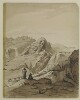
472. 'The main pass, Aden.' By Sir Henry Yule (1820-1899) Contributor: Sir Knight Henry Yule (artist) Date: 1844/1844 Language: English Geographic region: Aden Extent: 1 pen and ink and wash drawing on watercolour paper
473. ‘Route down the Tiban River from Karad to Majar (3 miles N. of Musemir.)’ Date: 1905/1905 Language: English Extent: 1 map
474. ‘Route through Persia on horse back’ Contributor: Survey of India (author) Date: 1888/1888 Language: English Extent: 1 map
475. ‘Route from Isfahan by Kermanshah to Muraga and return by Hamadan. Performed under Orders of Brigr. Genl. Malcolm by Lieut. E. Frederick of the Bombay Military Establishmt. AD. 1810’ Contributor: John Garstin (signer) Date: 1810/1810 Language: EnglishLatin Geographic region: Iran Extent: 1 map sheet
477. 'IRĀQ & PERSIA' Contributor: Survey of India (publisher) Date: 1925/1925 Language: English Geographic region: KirkukArdalānKirmānshahDiyālahSulaimāni Extent: 1 map
479. ‘Irāq, Persia & Turkey in Asia’ Date: 1923/1932 Language: English Geographic region: AzerbaijanDiza-GawarVanKirkukMosul Extent: 1 map
480. 'AKABA (Transjordan)' Date: 1937/1937 Language: English Geographic region: Akaba Extent: 1 photograph