13. Chart of the Persian Gulf Date: 1800/1899 Language: Dutch Geographic region: Persian Gulf Extent: 1 map
14. Four nautical charts related to the Persian Gulf and Gulf of Oman Contributor: Frederic Charles Danvers (attributed name) Date: 1800/1899 Language: Dutch Extent: 4 manuscript charts
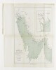
15. Chart of the Gulf of Oman Date: 1800/1899 Language: Dutch Geographic region: Gulf of Oman Extent: 1 map
16. 'File 2/32 I II. AVIATION. C. FOREIGN AVIATION. (I) Use Of Gwadur Landing Ground by K.L.M and Air France.’ Contributor: Air France (correspondent; subject)Sultan of Muscat and Oman, Āl Bū Sa'īd Dynasty (correspondent; subject)Persian Gulf Political Residency (correspondent)Koninklijke Luchtvaart Maatschappij, airline (correspondent; subject) Date: 1932/1939 Language: EnglishArabicFrenchDutch Geographic region: Gwadur Extent: 1 volume (255 folios)
17. Ḥikāyat Sulṭān Ibrāhīm ibn Adham. Dutch & Malay Date: Date Issued: 1822 Language: MalayDutchArabic Geographic region: Place of Production: io, Indonesia, BataviaIndonesia Extent: 1 online resource (4, 3, 4, 96, 9 pages)
18. Kalām Contributor: Collector: Kraus, Paul, 1904-1944Compiler: American University in Cairo. Rare Books and Special Collections Library Date: 1960; 1961; 1962; 1963; 1964; 1965; 1966; 1967; 1968; 1969; 1970; 1971; 1972; 1973; 1974; 1975; 1976; 1977; 1978; 1979; 1980; 1981; 1982; 1983; 1984; 1985; 1986; 1987; 1988; 1989 Language: GermanEnglishFrenchItalianDutch Medium: indexes (reference sources) Extent: 16.6 x 21 cm.; 2 p.
20. Dutch Maps of the Persian Gulf Contributor: Royal Dutch Geographical Society (publisher) Date: 1907/1907 Language: Dutch Geographic region: Persian Gulf Extent: 1 file (2 folios)