Titre original : A relation of a journey begun An. Dom. 1610 : foure bookes containing a description of the Turkish Empire, of Aegypt, of the Holy Land, of the remote parts of Italy and islands adjoyningNumérisé par le partenaire. Plusieurs annotations manuscrites en fin de volumeAppartient à l’ensemble documentaire : BbLevt0Descriptions et voyagesRécits de voyages
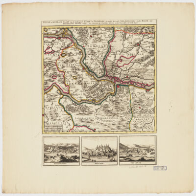
by Joachim Ottens.Relief shown pictorially.Colored in outline.Shows military points of interest related to the Battle of Belgrade, 1717.Includes ill. and views: Peter Wardein -- Belgrad -- Temeswar.Place names in Latin.Electronic reproduction. Cambridge, Mass. : Harvard College Library Digital Imaging Group, 2009. (Open Collections Program at Harvard University. Islamic Heritage Project). Copy digitized: Map Coll (Pusey) MAP-LC G6854.B5 1717 .O8.
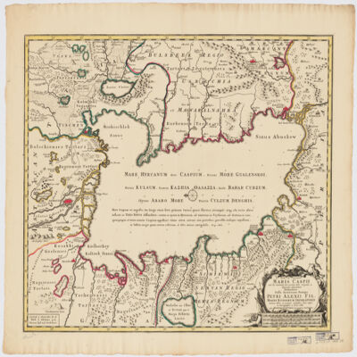
immenso labore et maximis sumptibus facta, atque ex autographo in lucem edita per Reinerum Ottens geographum Amstelaedam ; Iacob Keyser sculp.Covers portions of Iran, Turkmenistan, Kazakhstan, Russia and Azerbaijan.Relief shown pictorially. Depth shown by soundings.Oriented with North to the left.Colored in outline.Includes ill.Appears in: Atlas maior cum generales omnium totius orbis regnorum rerumpubl. atque insularum tum particulares praecipuarum in iis provinciarum ducatuum comitatuum ceterarum que minorum regionum ac divisionum tabulas geographicas continens ex optimis ac novissimis quibusque variorum autorum tabulis collectus et eleganti ordine dispositus / Reiner Ottens. [1641-1729]. Vol. 7, map No. 23.In Latin with a publication note in Dutch and place names in Greek, Russian, Persian, Arabic, and Turkish in Latin script.Electronic reproduction. Cambridge, Mass. : Harvard College Library Digital Imaging Group, 2009. (Open Collections Program at Harvard University. Islamic Heritage Project). Copy digitized: XXXXX Library: [call no.].
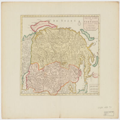
door Isaak Tirion ; J. Keyser get. on gesn.Covers Mongolia, Korea and portions of Russia, Iran, China and Japan.Relief shown by shading and pictorially.Electronic reproduction. Cambridge, Mass. : Harvard College Library Digital Imaging Group, 2009. (Open Collections Program at Harvard University. Islamic Heritage Project). Copy digitized: Map Coll (Pusey) : MAP-LC G7270 1732 .T5.
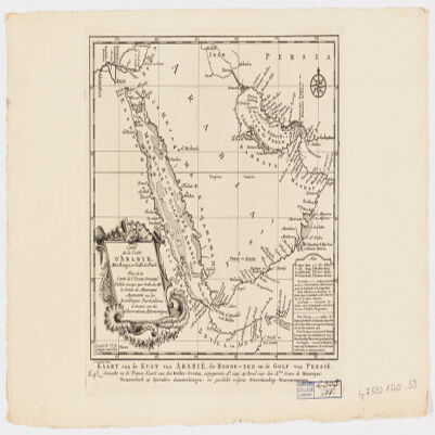
J. V. Schley.Prime meridian: Ferro.Depths shown by shading.Appears in: Histoire générale des voyages / Antoine-François Prevost. 1747-67. Vol. 1.Includes note.Map in French and Deutsch.Electronic reproduction. Cambridge, Mass. : Harvard Geospatial Library, 2009. Georeferenced image for use in a GIS.Electronic reproduction. Cambridge, Mass. : Harvard College Library Digital Imaging Group, 2009. (Open Collections Program at Harvard University. Islamic Heritage Project). Copy digitized: Map Coll (Pusey) : MAP-LC G7520 1740 .S3.
Series of four tracings related to the Persian Gulf and Gulf of Oman copied by Frederick Charles Danvers in the late 19th century. The original charts, produced in the second half of the 17th century by an anonymous Dutch chart maker, are housed in the State Archive (Nationaal Archief), The Hague, in 'VOC – Atlas van Isaac de Graaf'.4 manuscript charts
Distinctive Features:Depths shown by soundings with shoals and rocks represented by dots and crosses. Some settlements shown pictorially.Contains three charts showing: the coast from the Musandam Peninsula to Muscat, at the left portion of sheet; ‘De Bay van Mascatta’ in the top right; and Strait of Hormuz in the bottom right. Copied from original chart produced during an expedition along the Oman coast in 1666.3 maps on 1 sheetMaterials:Pen and ink with wash on tracing paperDimensions:523 x 349 mm or smaller, on sheet 525 x 738 mm
Distinctive Features:Depths in the Strait of Hormuz and along the coasts of Persia and Oman shown by soundings. Shoals and rocks represented by dots and crosses with annotations.Top and left margins are divided and marked with numbers.1 mapMaterials:Pen and ink with wash on tracing paperDimensions:517 x 739 mm
Distinctive Features:Depths along the coasts of Persia and Oman shown by soundings. Shoals and rocks indicated by dots and crosses with annotations. Settlements with Dutch East India Company’s trading posts represented pictorially.1 mapMaterials:Pen and ink with wash on tracing paperDimensions:550 x 740 mm
Distinctive Features:Depths along the coasts of Persia and Oman shown by soundings with shoals and rocks represented by dots and crosses.Left and bottom margins are divided and marked with numbers.1 mapMaterials:Pen and ink with wash on tracing paperDimensions:533 x 739 mm
en uit het Maleisch in het Nederduitsch overgebracht door Philippus Pieter Roorda van Eijsinga.Malay title pages have hijri date 1237 [1821 or 22].Electronic reproduction. Cambridge, Mass. : Harvard College Library Digital Imaging Group, 2009. (Open Collections Program at Harvard University. Islamic Heritage Project). Copy digitized: Widener Library: PL5139.H55 D8 1822x.In Malay. (Arabic and Roman scripts) with Dutch translation; translated from Arabic.Electronic reproduction. Cambridge, Mass. : Harvard College Library Digital Imaging Group, 2009. (Open Collections Program at Harvard University. Islamic Heritage Project). Copy digitized: Widener Library: PL5139.H55 D8 1822x .