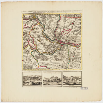
by Joachim Ottens.Relief shown pictorially.Colored in outline.Shows military points of interest related to the Battle of Belgrade, 1717.Includes ill. and views: Peter Wardein -- Belgrad -- Temeswar.Place names in Latin.Electronic reproduction. Cambridge, Mass. : Harvard College Library Digital Imaging Group, 2009. (Open Collections Program at Harvard University. Islamic Heritage Project). Copy digitized: Map Coll (Pusey) MAP-LC G6854.B5 1717 .O8.
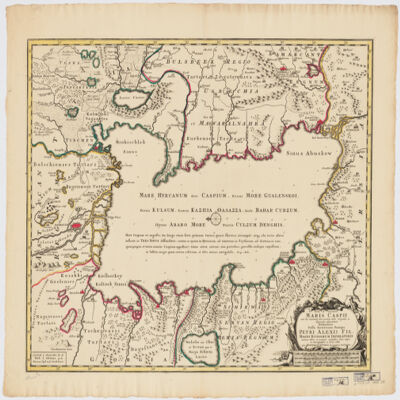
immenso labore et maximis sumptibus facta, atque ex autographo in lucem edita per Reinerum Ottens geographum Amstelaedam ; Iacob Keyser sculp.Covers portions of Iran, Turkmenistan, Kazakhstan, Russia and Azerbaijan.Relief shown pictorially. Depth shown by soundings.Oriented with North to the left.Colored in outline.Includes ill.Appears in: Atlas maior cum generales omnium totius orbis regnorum rerumpubl. atque insularum tum particulares praecipuarum in iis provinciarum ducatuum comitatuum ceterarum que minorum regionum ac divisionum tabulas geographicas continens ex optimis ac novissimis quibusque variorum autorum tabulis collectus et eleganti ordine dispositus / Reiner Ottens. [1641-1729]. Vol. 7, map No. 23.In Latin with a publication note in Dutch and place names in Greek, Russian, Persian, Arabic, and Turkish in Latin script.Electronic reproduction. Cambridge, Mass. : Harvard College Library Digital Imaging Group, 2009. (Open Collections Program at Harvard University. Islamic Heritage Project). Copy digitized: XXXXX Library: [call no.].
Titre original : A relation of a journey begun An. Dom. 1610 : foure bookes containing a description of the Turkish Empire, of Aegypt, of the Holy Land, of the remote parts of Italy and islands adjoyningNumérisé par le partenaire. Plusieurs annotations manuscrites en fin de volumeAppartient à l’ensemble documentaire : BbLevt0Descriptions et voyagesRécits de voyages
J. V. Schley.Prime meridian: Ferro.Depths shown by shading.Appears in: Histoire générale des voyages / Antoine-François Prevost. 1747-67. Vol. 1.Includes note.Map in French and Deutsch.Electronic reproduction. Cambridge, Mass. : Harvard Geospatial Library, 2009. Georeferenced image for use in a GIS.Electronic reproduction. Cambridge, Mass. : Harvard College Library Digital Imaging Group, 2009. (Open Collections Program at Harvard University. Islamic Heritage Project). Copy digitized: Map Coll (Pusey) : MAP-LC G7520 1740 .S3.
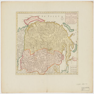
door Isaak Tirion ; J. Keyser get. on gesn.Covers Mongolia, Korea and portions of Russia, Iran, China and Japan.Relief shown by shading and pictorially.Electronic reproduction. Cambridge, Mass. : Harvard College Library Digital Imaging Group, 2009. (Open Collections Program at Harvard University. Islamic Heritage Project). Copy digitized: Map Coll (Pusey) : MAP-LC G7270 1732 .T5.
Distinctive Features:Depths along the coasts of Persia and Oman shown by soundings. Shoals and rocks indicated by dots and crosses with annotations. Settlements with Dutch East India Company’s trading posts represented pictorially.1 mapMaterials:Pen and ink with wash on tracing paperDimensions:550 x 740 mm
This file is comprised of a range of material compiled by George Nathaniel Curzon, mainly concerning matters relating to Persia but also relating to other areas in south Asia. It includes the following:Three copies of an official memorandum by Curzon (writing as Parliamentary Under-Secretary of State for Foreign Affairs), entitled 'Memorandum on the Persian Situation', dated 17 April 1896 and concerning British policy in Persia, including the actions to be taken in the event of the death of the present Shah of Persia (ff 3-10)Curzon's copies of official correspondence forwarded to the Marquess of Salisbury (Prime Minister Robert Arthur Talbot Gascoyne-Cecil) by Sir Philip Currie, British Ambassador in Constantinople, which includes enclosed letters from British representatives reporting on the condition of Nestorians living in Ottoman Turkey (ff 17-21)Three maps, two of which depict Chitral and the surrounding area, while the third shows the recently delimited boundary between Russian and Afghan territories (ff 26-28)A selection of newspaper cuttings containing articles relating to Persia, dating from 1889-1898 (ff 30-39)A copy of an edition of the
Journal of the Society of Arts, dated 16 February 1894 (ff 48-73)A copy of the following booklet:
Perzie. Overzicht van in de Nederlandsche taal uitegeven werken, gevolgd door een opgave van de voornaamste buitenlandsche schrijvers(an overview of works on Persia published in the Dutch language), by A Hotz, dated January 1897 (ff 74-99)A photograph of General Amenkoff (f 100)The material in the file ranges in date from 1889 to 1923; however, most of the material dates from between 1891 and 1898.1 file (99 folios)The contents of the file are largely arranged according to type of material; within this system of arrangement items are arranged in approximate chronological order.Foliation: the foliation sequence (used for referencing) commences at the front cover with 1, and terminates at the inside back cover with 101; these numbers are written in pencil and are located in the top right corner of the recto side of each folio.
This file contains correpsondence between the Political Agents at Bahrain and Kuwait; Secretary to the Political Resident in the Persian Gulf at Bushire; Charles Dalrymple Belgrave, Adviser to the Bahrain Government; Claud C L de Grenier, Director of Customs and Port Officer, Bahrain; Mesopotamia Persia Corporation; Khalil bin Ebrahim Kanoo [Khalīl bin Ibrāhīm Kānū]; Mohamed Yateem [Muḥammad Yatīm]; Port Director and Director-General of Navigation, Basrah; and the Acting Consuls for the Netherlands (Consulaat Der Nederlanden) in Karachi and Bombay.The correspondence concerns customs and duty regulations for cargo landed at Bahrain between April 1926 and January 1934. Included within these papers are: a list of landing charges at Bahrain (ff. 24-25); German, Swedish and Dutch enquiries regarding customs at Bahrain (ff. 39-47, 55-60, 242-246, 247-255); a 'Schedule of Fixed Customs Duty on Import Cargo by Native Crafts' and 'Schedule of Fixed Export Duty' (ff. 48-50); two copies of 'The Government of Bahrein Custom House and Import Yard: Tariff of Import Yard Charges' (24 May 1929), an A to Z list of items and their charges giving khanchia, porterage, pier-fee and Municipal Tax (
baladiyya) (ff. 60A-146); customs regulations in Persia (ff. 147-148, 155-159) and Qatar (ff. 160-161); correspondence regarding the import of tobacco (ff. 186-187, 194-196) and alcohol (ff. 231-233); and public notices relating to the increased rate of customs duty on certain items in 1932 (ff. 197-198, 228-230).1 file (240 folios)This file is arranged approximately in chronological order.Foliation: Foliation is written in pencil, in the top right corner of the recto of each folio. It begins with the first item of correspondence, on number 1, and ends on the inside of the back cover, on number 276. Foliation errors: f. 46 is followed by f. 46A; f. 47 is followed by f. 47A; f. 60 is followed by f. 60A; f. 242 is followed by f. 242A; f. 252 is followed by f. 252A. The following folios are missing from the sequence: f. 44, f. 163, ff. 173-181, ff. 204-227, f. 235, ff. 238-241 and ff. 248-251.
Facsimile of a 1646 map of the Persian Gulf from the ship journal of Captain Cornelis Roobacker. Published by the journal of the Royal Dutch Geographical Society (
Tijdschrift van het Koninklijk Nederlandsch Aardrijkskundig Genootschap), 1907.1 mapMaterials: Printed in colour on paperDimensions: 519 x 708mm, on sheet 609 x 914mm
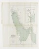
Distinctive Features:Depths shown by soundings with shoals and rocks represented by dots and crosses. Some settlements shown pictorially.Contains three charts showing: the coast from the Musandam Peninsula to Muscat, at the left portion of sheet; ‘De Bay van Mascatta’ in the top right; and Strait of Hormuz in the bottom right. Copied from original chart produced during an expedition along the Oman coast in 1666.3 maps on 1 sheetMaterials:Pen and ink with wash on tracing paperDimensions:523 x 349 mm or smaller, on sheet 525 x 738 mm