481. ‘A Pilgrimage to Nejd, the cradle of the Arab race. A visit to the court of the Arab Emir, and "Our Persian Campaign."' Contributor: Murray, John, publishers (publisher)Anne Isabella Noel Blunt (author)Francis Scawen Blunt (author)Wilfrid Scawen Blunt (author) Date: 1881/1881 Language: English Extent: 1 volume (283 pages)
482. ‘A Pilgrimage to Nejd, the cradle of the Arab race. A visit to the court of the Arab Emir, and "Our Persian Campaign."' Contributor: Murray, John, publishers (publisher)Anne Isabella Noel Blunt (author)Wilfrid Scawen Blunt (author) Date: 1881/1881 Language: English Extent: 1 volume (273 pages)
483. 'APPROXIMATE BOUNDARIES OF JOWASIM TRIBE AND PART BINI YAS TERRITORIES.' Date: 1935/1935 Language: English Geographic region: Trucial Coast Extent: 1 map
485. 'Perso-Afghan frontier. Report on Hashtadan' Contributor: Secretary of State for Foreign Affairs (recipient)HM Ambassador to Iran (correspondent)Government of India (recipient)Governor-General of Khorassan (correspondent)Assistant Commissioner, Afghan Boundary Commission (correspondent)Commissioner, Afghan Boundary Commission (correspondent)William Rudolph Henry Merk (correspondent)Albert Frederick Laessoe De (correspondent) Date: 1885/1885 Language: English Geographic region: PersiaAfghanistanMashadKafir KalaKarazHashtadan Extent: 1 file (6 folios)
486. 'Perso-Afghan Frontier. MEMORANDUM BY SIR WEST RIDGEWAY.' Date: 1887/1887 Language: English Geographic region: Hashtadan Extent: 1 file (1 folio)
487. ‘Perso-Balūch Boundary from B.P. 11 to Kūh-i-Malik Sīāh’ Contributor: Surveyor General (author)Survey of India (author) Date: 1932/1932 Language: English Extent: 1 map
488. ‘Kuwait – Saudi Frontier.’ Contributor: Political Resident, Persian Gulf (correspondent) Date: 1948/1949 Language: English Geographic region: Gurain Extent: 1 file (22 folios)
489. 'Boundary between Persia and North-West Baluchistan' Contributor: Frederick Weston Peile Macdonald (author)Hermann Anderson Haines (author) Date: 1893/1893 Language: English Geographic region: PersiaBaluchistanKohukKharanMekran Extent: 9 folios
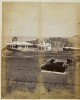
490. 'HODEIDA. View from S.E.' Date: 1932/1932 Language: English Geographic region: Hodeida Extent: 1 photograph
491. ‘The Russo-Turkish war. 1877.’ Date: 1877/1877 Language: English Extent: 1 file (2 items, 57 folios)
492. ‘Russo-Turkish War, 1877. Operations in Asia.’ Contributor: Royal Engineers (author) Date: 1877/1877 Language: English Geographic region: KarsTurkey Extent: 1 item (20 folios)
493. ‘The Russo-Turkish War. 1877. Operations in Europe.’ Contributor: Government of India, Quarter Master General's Department, Intelligence Branch (author) Date: 1877/1877 Language: English Geographic region: Danube RiverBulgariaRomania Extent: 1 item (33 folios)
494. 'THE WAR WITH TURKEY. Note by the Under Secretary, India Office.' Contributor: Permanent Under-Secretary of State for India (author) Date: 1916/1916 Language: English Geographic region: TurkeyOttoman Empire Extent: 1 file (3 folios)
495. 'THE WAR WITH TURKEY. Memorandum by Political Department, India Office.' Contributor: India Office, Secretary to the Political and Secret Department (author) Date: 1916/1916 Language: English Geographic region: GermanySuez CanalTurkeyOttoman Empire Extent: 4 folios
496. ‘Accounts’ Contributor: Political Agent, Doha (author) Date: 1950/1951 Language: English Geographic region: DohaQatar Extent: 1 file (28 folios)
497. ‘Al Husen, stronghold of Shekh Awas Al Ahmadi in the Wadi Tiban.’ Date: 1905/1905 Language: English Extent: 1 illustration
498. 'Excavations in Babylon' Photographer: Wilfrid Malleson Date: 1906/1906 Language: English Geographic region: Babylon Extent: 1 b&w silver gelatin print
499. 'Government of India, Army Department, General Staff Branch: Index to Summaries of Intelligence from Force `D' Nos. 316-232 (Serial No. 65)' Date: 1919/1919 Language: English Extent: 1 volume (5 folios)
500. 'Government of India, Army Department, General Staff Branch: Index to Summaries of Intelligence from Mesopotamia Expeditionary Force, Nos. 402-421 (Serial No. 39)' Date: 1921/1921 Language: English Extent: 1 volume (7 folios)
501. 'Government of India, Army Department, General Staff Branch: Index to Summaries of Intelligence from Headquarters British Forces in Iraq, Nos. 26-50 (Serial No. 30)' Date: 1923/1923 Language: English Extent: 1 volume (11 folios)
502. 'Government of India, Army Department, General Staff Branch: Index to Summaries of Intelligence from Headquarters British Forces in Iraq, Nos. 422-451 (Serial No. 35)' Date: 1922/1922 Language: English Extent: 1 volume (8 folios)
503. 'Government of India, Army Department, General Staff Branch: Index to Summaries of Intelligence from Headquarters British Forces In Iraq, Nos. 452-464 (Serial No 18)' Date: 1922/1922 Language: English Extent: 1 volume (7 folios)
504. 'Al-Hautah: Capital of the Lahej District, showing the Sultan's Palace'. Photographer: Unknown Contributor: Frederick Mercer Hunter (author) Date: 1873/1877 Language: English Geographic region: Aden Extent: 1 albumen print
505. 'Political Service in the Middle East' Date: 1918/1918 Language: English Geographic region: Mesopotamia Extent: 5 folios
506. 'Aden Boundary Commission Survey Sketch Accompanying No. 19 of 15th March 1904' Date: 1904/1904 Language: English Extent: 1 folio
507. 'Aden Boundary Commission Survey Sketch Accompanying No. 21 of 15th March 1904' Date: 1904/1904 Language: English Extent: 1 folio
508. 'MAP No.1. to illustrate operations described in Chapter VI.' Contributor: Ordnance Survey (publisher) Date: 1922/1922 Language: English Extent: 1 map
509. 'MAP No. 1 ADMINISTRATIVE LAY-OUT IN PALESTINE OCTOBER 1936 PALESTINE Administration Map' Contributor: Survey of Palestine (publisher) Date: 1939/1939 Language: English Geographic region: Tel AvivJerusalemHaifa Extent: 1 map
511. 'MAP No. 3 To illustrate fighting near Shaiba.' Contributor: Ordnance Survey (publisher) Date: 1922/1922 Language: English Extent: 1 map
512. 'MAP No. 2. to illustrate fighting near Qurna.' Contributor: Ordnance Survey (publisher) Date: 1922/1922 Language: English Extent: 1 map
514. 'MAP No. 4 to illustrate operations in Persian Arabistan.' Contributor: Ordnance Survey (publisher) Date: 1922/1922 Language: English Extent: 1 map
515. 'MAP No. 5 to illustrate operations in the Akaika Channel 27th. June to 5th. July 1915' Contributor: Ordnance Survey (publisher) Date: 1922/1922 Language: English Extent: 1 map
516. 'MAP No. 7 To illustrate the Battle of Kut 28th. September 1915' Contributor: Ordnance Survey (publisher) Date: 1922/1922 Language: English Extent: 1 map
517. 'Map 1. Mesopotamia. Administrative Divisions and Chief Towns' Date: 1916/1916 Language: English Geographic region: Mesopotamia Extent: 1 map
518. 'MAP 10. TO ILLUSTRATE THE AFFAIR OF UMM AT TUBUL. Positions at dawn, 1st. December, 1915.' Contributor: Ordnance Survey (publisher) Date: 1924/1924 Language: English Extent: 1 map
519. 'MAP 11. TO ILLUSTRATE THE DEFENCE OF KUT AL AMARA: December 1915, to April 1916.' Contributor: Ordnance Survey (publisher) Date: 1924/1924 Language: English Extent: 1 map
520. 'MAP 12. THE FORT AT KUT: WITH SPECIAL REFERENCE TO THE TURKISH ATTACK ON 24TH. DECEMBER, 1915.' Contributor: Ordnance Survey (publisher) Date: 1924/1924 Language: English Extent: 1 map
521. 'MAP 13. RIVER TIGRIS BETWEEN ALI GHARBI AND SHUMRAN.' Contributor: Ordnance Survey (publisher) Date: 1924/1924 Language: English Extent: 1 map
522. 'MAP 14. MAP TO ILLUSTRATE THE ACTION OF SHAIKH SAAD. 6th. - 9th. January, 1916.' Contributor: Ordnance Survey (publisher) Date: 1924/1924 Language: English Extent: 1 map
523. 'MAP 15 MAP TO ILLUSTRATE THE ACTION OF THE WADI.' Contributor: Ordnance Survey (publisher) Date: 1924/1924 Language: English Extent: 1 map
524. 'MAP 16 MAP TO ILLUSTRATE THE FIRST ATTACK ON HANNA. 21st. January, 1916.' Contributor: Ordnance Survey (publisher) Date: 1924/1924 Language: English Extent: 1 map
525. 'MAP 17. MAP TO ILLUSTRATE THE ATTACK ON THE DUJAILA REDOUBT: 8TH. MARCH, 1916.' Contributor: Ordnance Survey (publisher) Date: 1924/1924 Language: English Extent: 1 map
526. 'MAP 18. To illustrate Tigris Corps Operation Order No. 26 dated 6th. March 1916' Contributor: Ordnance Survey (publisher) Date: 1924/1924 Language: English Extent: 1 map
527. 'MAP 19 MAP TO ILLUSTRATE OPERATIONS BETWEEN 10TH. MARCH & END OF APRIL 1916.' Contributor: Ordnance Survey (publisher) Date: 1924/1924 Language: English Extent: 1 map
528. 'Map 2. Mesopotamia. Racial Divisions' Date: 1916/1916 Language: English Geographic region: Mesopotamia Extent: 1 map
529. 'MAP 20 MAP TO ILLUSTRATE THE ACTION OF BAIT ISA ON 17TH. & 18TH. APRIL 1916 AND THE ATTACK ON SANNAIYAT 22ND. APRIL 1916' Contributor: Ordnance Survey (publisher) Date: 1924/1924 Language: English Extent: 1 map
530. 'MAP 21 TO ILLUSTRATE OPERATIONS ON THE TIGRIS FRONT, MAY TO 12TH. DECEMBER, 1916.' Contributor: Ordnance Survey (publisher) Date: 1925/1925 Language: English Extent: 1 map
531. 'MAP 22 TO ILLUSTRATE OPERATIONS ON THE TIGRIS._13TH. DECEMBER 1916, TO 25TH. FEBRUARY 1917.' Contributor: Ordnance Survey (publisher) Date: 1925/1925 Language: English Extent: 1 map
532. 'MAP 23 MAP TO ILLUSTRATE OPERATIONS AGAINST THE HAI SALIENT AND THE DAHRA BEND POSITIONS, AND THE PASSAGE OF THE TIGRIS: 11TH. JANUARY-24TH. FEBRUARY, 1917.' Contributor: Ordnance Survey (publisher) Date: 1925/1925 Language: English Extent: 1 map
533. 'MAP 25. TO ILLUSTRATE OPERATIONS RESULTING IN THE CAPTURE OF BAGHDAD, on 11th. March, 1917.' Contributor: Ordnance Survey (publisher) Date: 1925/1925 Language: English Extent: 1 map
534. 'MAP 26 SKETCH MAP OF AREA NORTH OF BAGHDAD.' Contributor: Ordnance Survey (publisher) Date: 1925/1925 Language: English Extent: 1 map
535. 'MAP 27 TO ILLUSTRATE THE ACTION OF MUSHAHIDA. 14th. March, 1917.' Contributor: Ordnance Survey (publisher) Date: 1925/1925 Language: English Extent: 1 map
536. 'MAP 28 TO ILLUSTRATE THE FIRST ACTION OF THE JABAL HAMRIN. 25th. March, 1917.' Contributor: Ordnance Survey (publisher) Date: 1925/1925 Language: English Extent: 1 map
537. 'MAP 29 TO ILLUSTRATE THE AFFAIR OF DUQMA. 29th. March, 1917.' Contributor: Ordnance Survey (publisher) Date: 1925/1925 Language: English Extent: 1 map
538. 'Map 3. Mesopotamia' Date: 1916/1916 Language: English Geographic region: Mesopotamia Extent: 1 map
539. 'MAP 30 TO ILLUSTRATE THE OPERATIONS ABOUT THE KHALIS CANAL. 9th.-15th. April, 1917.' Contributor: Ordnance Survey (publisher) Date: 1925/1925 Language: English Extent: 1 map
540. 'MAP 32 TO ILLUSTRATE THE ACTION OF ISTABULAT. 21st. and 22nd. April, 1917.' Contributor: Ordnance Survey (publisher) Date: 1925/1925 Language: English Extent: 1 map
541. 'MAP 33 SKETCH MAP TO ILLUSTRATE THE ACTION OF ADHAIM. 30th. April, 1917.' Contributor: Ordnance Survey (publisher) Date: 1925/1925 Language: English Extent: 1 map
542. 'MAP 35. TO ILLUSTRATE OPERATIONS IN THE JABAL HAMRIN; OCTOBER AND DECEMBER, 1917.' Contributor: Ordnance Survey (publisher) Date: 1927/1927 Language: English Extent: 1 map
543. 'MAP 36 TO ILLUSTRATE THE ACTIONS AT DAUR ON THE 22ND. AND TIKRIT ON THE 5TH. NOVEMBER, 1917.' Contributor: Ordnance Survey (publisher) Date: 1927/1927 Language: English Extent: 1 map
544. 'MAP 37 TO ILLUSTRATE OPERATIONS ON THE EUPHRATES LINE. March, 1918.' Contributor: Ordnance Survey (publisher) Date: 1927/1927 Language: English Extent: 1 map
545. 'MAP 38 TO ILLUSTRATE THE ACTION OF KHAN BAGHDADI. 26th. March, 1918.' Contributor: Ordnance Survey (publisher) Date: 1927/1927 Language: English Extent: 1 map
546. 'MAP 39 TO ILLUSTRATE OPERATIONS IN THE KIFRI-KIRKUK AREA, APRIL AND MAY, 1918.' Contributor: Ordnance Survey (publisher) Date: 1927/1927 Language: English Extent: 1 map
547. 'MAP 40 TO ILLUSTRATE THE CAVALRY AFFAIR of the 27th. April, 1918, and THE ACTION OF TUZ KHURMATLI, 29th. April, 1918.' Contributor: Ordnance Survey (publisher) Date: 1927/1927 Language: English Extent: 1 map
548. 'MAP 41 SKELETON MAP TO ILLUSTRATE THE OPERATIONS OF "DUNSTERFORCE", 1918.' Contributor: Ordnance Survey (publisher) Date: 1927/1927 Language: English Extent: 1 map
549. 'MAP 42 TO ILLUSTRATE THE OPERATIONS AT BAKU. AUGUST-SEPTEMBER, 1918.' Contributor: Ordnance Survey (publisher) Date: 1927/1927 Language: English Extent: 1 map
550. 'MAP 43 TO ILLUSTRATE OPERATIONS ON THE TIGRIS. 18th.-30th. October, 1918.' Contributor: Ordnance Survey (publisher) Date: 1927/1927 Language: English Extent: 1 map
551. 'MAP 45 TO ILLUSTRATE THE BATTLE OF SHARQAT. 29th. October, 1918.' Contributor: Ordnance Survey (publisher) Date: 1927/1927 Language: English Extent: 1 map
552. 'QATAR SUCCESSION' Contributor: Emir of Qatar (correspondent)Political Resident, Persian Gulf (correspondent)Indian Political Service, External Affairs Department (correspondent)Petroleum Concessions Limited, Manager, Bahrain (correspondent) Date: 1944/1949 Language: EnglishArabic Geographic region: Qatar Extent: 1 file (49 folios)
554. ‘The several bays near Cape of Aden, on the Arabian coast, surveyed trigonometrically’ Contributor: J & C Walker, engravers (surveyor)Stafford Bettesworth Haines (surveyor)John Walker (surveyor) Date: 1839/1839 Language: English Geographic region: Aden Extent: 1 map sheet
555. 'Persian Gulf - Turkish jurisdiction along the Arabian coast (Part I)' Contributor: India Office, Assistant Secretary to the Political and Secret Department, (author) Date: 1879/1879 Language: EnglishFrench Geographic region: QatarArabian PeninsulaAdenBahrainMuscatPersian GulfTrucial CoastEl Hassa Extent: 1 file (14 folios)
556. 'Persian Gulf - Turkish jurisdiction along the Arabian coast (Part III)' Contributor: India Office, Assistant Secretary to the Political and Secret Department, (author) Date: 1881/1881 Language: English Geographic region: BahrainPersian GulfQatarEl Bidaa Extent: 1 file (15 folios)
557. 'Persian Gulf - Turkish jurisdiction along the Arabian coast (Part II)' Contributor: India Office, Assistant Secretary to the Political and Secret Department, (author) Date: 1879/1879 Language: EnglishFrench Geographic region: QatarArabian PeninsulaBahrainPersian GulfTrucial CoastOdeidEl BidaaLahsaZobarah Extent: 1 file (21 folios)
558. 'Persian Gulf - Turkish jurisdiction along the Arabian coast (Part IV)' Contributor: India Office, Assistant Secretary to the Political and Secret Department, (author) Date: 1884/1884 Language: EnglishFrench Geographic region: Qatar Extent: 1 file (8 folios)
559. 'PERSIAN GULF - PORT OF KUWEIT Surveyed by Lieutts. T.H.H. Hand, C.S. Hickman, E.J. Headlam, A.G. Bingham and W.K. Thyne, R.I.M., under the direction of Captain T.H. Heming, R.N., in charge of the Marine Survey of India, 1905' Date: 1906/1906 Language: English Extent: 1 map
560. ‘The Persian Gulf and South Sea Isles' Contributor: Edgar Collins Boteler (author)Horace Cox (publisher) Date: 1904/1904 Language: English Extent: 1 volume (180 pages)
561. 'Persian Gulf' Contributor: India Office, Assistant Secretary to the Political and Secret Department, (author)Persian Gulf Political Residency (correspondent)Government of India (correspondent) Date: 1888/1888 Language: English Geographic region: El KatrEl Bidaa Extent: 1 file (3 folios)
562. 'The Persian Gulf' Date: 1935/1935 Language: English Geographic region: IraqKuwaitPersian GulfSaudi Arabia Extent: 1 file (2 folios)
564. 'Persian Gulf. Procedure to be adopted in negotiations with Arab & Persian Gulf Rulers' Date: 1932/1933 Language: English Geographic region: Kalba Extent: 1 file (17 folios)
565. 'Persian Gulf. Turkish claims on the Arabian coast' Date: 1903/1903 Language: English Geographic region: El KatrTrucial CoastTurkeyOdeid Extent: 1 file (5 folios)
566. 'Persian Gulf. Limits of Turkish Jurisdiction on the Arabian Coast' Contributor: Foreign Office (correspondent)India Office, Assistant Secretary to the Political and Secret Department, (author) Date: 1888/1888 Language: English Geographic region: El BidaaOttoman EmpireKatif Extent: 1 file (4 folios)
567. 'Persian Gulf; Muscat and Zanzibar' Contributor: Sir Knight George Russell Clerk (author) Date: 1868/1868 Language: English Extent: 4 folios
568. 'PERSIAN GULF AND ADJACENT COUNTRIES' Date: 1908/1908 Language: English Geographic region: Persian Gulf Extent: 1 map
569. 'PERSIAN GULF AND ADJACENT COUNTRIES' Contributor: War Office, Topographical Section, General Staff (publisher) Date: 1908/1908 Language: English Geographic region: Persian Gulf Extent: 1 map
571. 'PERSIAN GULF AND ADJACENT COUNTRIES' Contributor: War Office, Topographical Section, General Staff (publisher) Date: 1911/1911 Language: English Extent: 1 map
572. 'PERSIAN GULF AND GULF OF OMAN. RESOURCES AND COAST DEFENCES.' Contributor: Admiralty, Naval Intelligence Department (author) Date: 1903/1903 Language: English Geographic region: Persian GulfGulf of Oman Extent: 56 folios
573. 'PERSIAN GULF AND GULF OF OMAN. RESOURCES AND COAST DEFENCES. 1903.' Contributor: Admiralty, Naval Intelligence Department (publisher) Date: 1903/1903 Language: English Geographic region: Persian GulfGulf of Oman Extent: 1 volume (55 folios)
574. 'THE PERSIAN GULF' Date: 1946/1946 Language: English Geographic region: Persian Gulf Extent: 1 file (32 folios)
576. 'Persian Gulf. Handbooks prepared under the direction of the Historical Section of the Foreign Office - no 81' Date: 1919/1919 Language: English Geographic region: Persian Gulf Extent: 1 volume (44 folios)