"The first comprehensive description of ancient and modern Egyptcompiled by the 165 members of the Institut de l'Egypte established by Napoleon to accompany his expedition to Egypt in 1798-1801. This exhaustive survey of all aspects of ancient and modern life in Egypt was carried out under the supervision of the mathematician Gaspard Mongethe appointed President of the new Institute (of which Napoleon was Vice-President)."
dressée au Service géographique de l'armée.Covers also a portion of Algeria and Libya.Relief shown by shading and spot heights. Depth shown by isolines.In French with place names in Arabic and Latin in Latin script.Table of Contents: "Tunisie (800 000e) Flle Nord" -- "Tunisie (800 000e) Flle Sud".
dressée au Service géographique de l'armée.Covers also a portion of Algeria and Libya.Relief shown by shading and spot heights. Depth shown by isolines.In French with place names in Arabic and Latin in Latin script.Table of Contents: "Tunisie (800 000e) Flle Nord" -- "Tunisie (800 000e) Flle Sud".
dressée au Service géographique de l'armée.Covers also a portion of Algeria and Libya.Relief shown by shading and spot heights. Depth shown by isolines.In French with place names in Arabic and Latin in Latin script.Table of Contents: "Tunisie (800 000e) Flle Nord" -- "Tunisie (800 000e) Flle Sud".
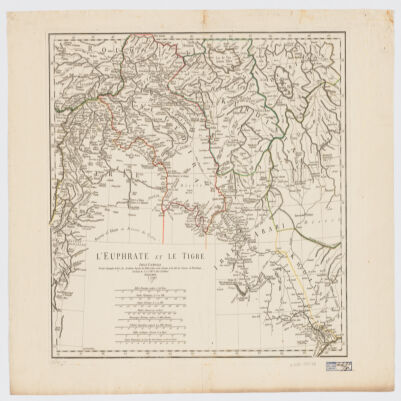
par le Sr. d'Anville ; Guill. De La Haye.Covers portions of Jordan, Syria, Lebanon, Israel, Turkey, Azerbaijan, Iran and Iraq.Relief shown pictorially.Colored in outline.In French with many place names also given with Roman-era Latin forms.Electronic reproduction. Cambridge, Mass. : Harvard College Library Digital Imaging Group, 2009. (Open Collections Program at Harvard University. Islamic Heritage Project). Copy digitized: XXXXX Library: [call no.].Electronic reproduction. Cambridge, Mass. : Harvard Geospatial Library, 2009. Georeferenced image for use in a GIS.