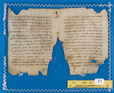
1. Glossary T-S K7.3 Date: 6th-19th century Language: HebrewFrench Medium: Vellum Extent: Leaf: (height: 10.8 cm, width: 16.1 (1 leaf: 8) cm)
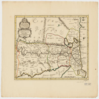
2. Ægyptus antiqua divisa in Nomos Creator: Duval, P. (Pierre), 1619-1682 (Creator) Date: Date Issued: 1652?] Language: LatinFrench Geographic region: Place of Production: ne, Netherlands, [AmsterdamEgypt Extent: 1 map : hand col. ; 35 x 50 cm.
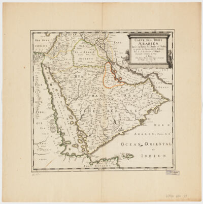
3. Carte des trois Arabiestirée en partie de l'Arabe de Nubie, en partie de diuers autres autheurs Creator: Sanson, Nicolas, 1600-1667 (المنشئ) Date: Date Issued: 1654 Language: French Geographic region: Place of Production: fr, France, ParisArabian Peninsula Extent: 1 map : hand col. ; 39 x 47 cm.
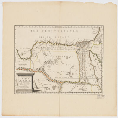
4. Royme., et désert de Barca et l'Égypte divisée en ses douze Cassifs, ou Gouvernemens Creator: Sanson, Nicolas, 1600-1667 (المنشئ) Date: Date Issued: 1655 Language: French Geographic region: Place of Production: fr, France, ParisEgyptLibya Extent: 1 map : hand col. ; 32 x 50 cm.
5. L'Égypte de Murtadi, fils du Gaphiphe, ou il est traité des Pyramides, du débordement du Nil, & des autres merveilles de cette Province, selon les opinions et traditions des Arabes / de la traduction de Pierre Vattier Sur un Manuscrit Arabe tiré de la Bibliothèque de feu Monseigneur le Cardinal Mazarin Creator: Ibn al-ʿAfīf, Murtaḍá ibn Ḥātim ibn al-Musallam (1154-1237) Contributor: Vattier, Pierre (1623-1667). Traducteur Date: 1666 Language: French
6. A generall mapp of the Coast of Barbarie, where in are the Kingdoms, and Estates of Morocco, Fez, Algiers, Tunis and Tripolialso the Kingdoms, Estates and Deserts of Barca, Egipt, Libya, Biledulgerid, Segelmesse and Darha: with the circumjacent counteries Creator: Sanson, Nicolas, 1600-1667 (المنشئ) Date: Date Issued: 1667?] Language: EnglishFrench Geographic region: Place of Production: enk, England, [LondonMoroccoTunisiaAlgeriaMauritania Extent: 1 map on 2 sheets ; 28 x 106 cm, sheets 35 x 57 cm and 35 x 59 cm.
7. A generall mapp of the Coast of Barbarie, where in are the Kingdoms, and Estates of Morocco, Fez, Algiers, Tunis and Tripolialso the Kingdoms, Estates and Deserts of Barca, Egipt, Libya, Biledulgerid, Segelmesse and Darha: with the circumjacent counteries Creator: Sanson, Nicolas, 1600-1667 (المنشئ) Date: Date Issued: 1667?] Language: EnglishFrench Geographic region: Place of Production: enk, England, [LondonMoroccoTunisiaAlgeriaMauritania Extent: 1 map on 2 sheets ; 28 x 106 cm, sheets 35 x 57 cm and 35 x 59 cm.
8. "Relation de divers voyages faits dans l'Afriquedans l'Amerique& aux Indes Occidentales. La description du royaume de Juda& quelques particularitéz touchant la vie du roy regnant. La relation d'une isle nouvellement habitée dans le détroit de Malaca en Asie& l'histoire de deux princes de Golconde. Par le sieur Dralsé de Grand-Pierre" Creator: Dralsé de Grand-Pierre Date: 1718 Language: French Extent: 5 p. l., 352, 4 p. 17 cm.
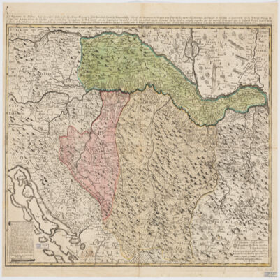
9. Le Royaume de Bosnie, dans son entier, dédié a son Excellence Monseignr. le feld Maréchal Comte de Khewenhüller Colonel d'un Régiment de Dragon Vice Roy d'Esclavonie, du Duché de Syrmie et Gouverneur de la Forteresse d'Essegg etc Creator: Briffaut, Étienne. (المنشئ) Date: Date Issued: 1740 Language: FrenchLatin Geographic region: Place of Production: fr, France, VienneBosnia and HerzegovinaCroatia Extent: 1 map : hand col. ; 60 x 90 cm.
10. Relation du voyage fait en Egypte par le Sieur Granger, en l'année 1730 : où l'on voit ce qu'il y a de plus remarquable, particulièrement sur l'Histoire naturelle / Granger Creator: Granger, Claude (16 Date: 1745 Language: French
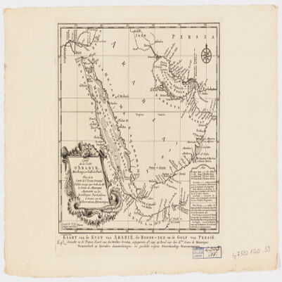
11. Carte de la coste d'Arabie, Mer Rouge et Golfe de Persetirée de la Carte de l'Océan Oriental publiée en 1740 par Ordre de Mgr le Comte de Maurepas augmentée sur des remarques particulières et dressée sur des observations astronomiques = Kaart van de Kust van Arabië, de Roode-Zee en de Gulf van Persië Gemaakt na de Fransse-Kaart van den Ooster-Ocean uitgegeven A. 1740 op Bevel van den Hre Grave de Maurepas Vermeederd op byzondere Aanmerkingen, en geschikt volgens Sterrekundige-Waarnemingen Creator: Schley, Jacobus van der, 1715-1779 (المنشئ) Date: Date Issued: between 1747 and 1767] Language: FrenchDutch Geographic region: Place of Production: ne, Netherlands, [HagueArabian Peninsula Extent: 1 map ; 24 x 21 cm.
12. Description historique et géographique des plaines d'Heliopolis et de Memphis / [par C.-L. Fourmont] Creator: Fourmont, Claude-Louis (1703-1780) Contributor: Briasson, Antoine-Claude (libraire prétendu). 3060Duchesne, Nicolas-Bonaventure (1710?-1765). 3060Simon, Claude-François (1710?-1767). 3060 Date: 1755 Language: French
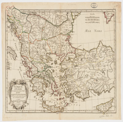
13. Turquie d'Europe et partie de celle d'Asie divisée par grandes provinces et gouvernemts Creator: Janvier, Jean Denis (المنشئ) Date: Date Issued: [1760?] Language: French Geographic region: Place of Production: fr, France, BordeauxBalkan PeninsulaTurkeyThrace, Eastern (Turkey)
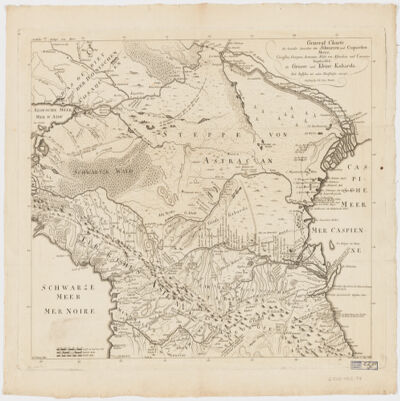
14. General Charte der Laender Zwischen dem Schwarzen und Caspischen MeereCircassien, Georgien, Armenien, Wüste von Astrachan und Caucasus hauptsoechlich die Grosse und Kleine Kabarda Creator: Treuttel, Jean-Georges, 1744-1826 (المنشئ) Date: Date Issued: [between 1765 and 1800?] Language: GermanFrench Geographic region: Place of Production: gw, Germany, StrasburgRussia (Federation)GeorgiaCaucasus, South Extent: 1 map ; 46 x 57 cm.
15. Histoire du commerce et de la navigation des Égyptiens, sous le Regne des Ptolémées / par Ameilhon Creator: Ameilhon, Hubert-Pascal (1730-1811) Date: 1766 Language: French
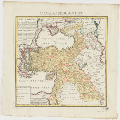
16. Turcia Asiaticaexhibens Natoliam modernam, in suos beglirbegatus divisam, itemque reliquos beglirbegatus, sive gubernationes et Prœfecturas generales, in regionibus Georgiæ, Armeniæ, Mespotamiæ, Syriæ et Arabiæ sitos, una cum Mari Nigro, Mari Azowiensi, Mari di Marmora, et Mari Ægeo, atque adiacentibus Insulis : C. P. S. C. M. = Carte de la Turquie asiatique contenant la Natolie moderne divisée en les beglerbeys & Creator: Homann Erben (Firm) (Creator) Date: Date Issued: 1771 Language: LatinFrench Geographic region: Place of Production: gw, Germany, NorimbergæMiddle EastTurkey Extent: 1 map : hand col. ; 44 x 51 cm.
17. 'Description de l'Arabie d'après les observations et recherches faites dans le pays même' Contributor: Carsten Niebuhr (author)Ferdinand Louis Mourier (translator) Date: 1774/1774 Language: FrenchArabic Extent: 1 volume (372 pages)
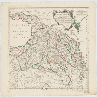
18. Carte de la Géorgie et des pays situés entre la mer Noire et la mer Caspiennedessinée en 1738 d'après les Cartes, Mémoires, Mesures et Observations des gens du Pays Creator: Santini, P. (المنشئ) Date: Date Issued: 1775 Language: FrenchGeorgian Geographic region: Place of Production: it, Italy, VeniceGeorgia (Republic)Armenia Extent: 1 map : hand col. ; 46 x 64 cm.
19. ‘Voyage en Arabie & en d’autres Pays circonvoisins’ [volume 1] Contributor: S J Baalde (publisher)J von Schoonhoven and Company (publisher)Carsten Niebuhr (author)Peter Forrskål (author)Ferdinand Louis Mourier (translator) Date: 1776/1776 Language: EnglishFrench Extent: 1 volume (409 pages)
20. ‘Voyage en Arabie & en d’autres Pays circonvoisins’ [volume 2] Contributor: S J Baalde (publisher)J von Schoonhoven and Company (publisher)Peter Forrskål (author)Carsten Niebuhr (author)Ferdinand Louis Mourier (translator) Date: 1776/1776 Language: EnglishFrench Extent: 1 volume (389 pages)
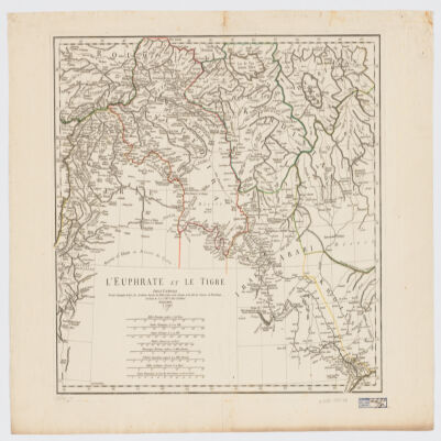
21. L' Euphrate et le Tigre Creator: Anville, Jean Baptiste Bourguignon d', 1697-1782 (المنشئ) Date: Date Issued: 1779 Language: FrenchLatin Geographic region: Place of Production: fr, France, [ParisEuphrates RiverTigris RiverIraqSyriaTurkey Extent: 1 map : hand col. ; 42 x 51 cm.
22. Kitāb Mukālamāt ʻArabīyah : manuscript, [ca. 1783] Date: Date Issued: 1783 Language: ArabicFrench Geographic region: Place of Production: le, Lebanon Extent: 1 v. (120 leaves) ; 22 cm.
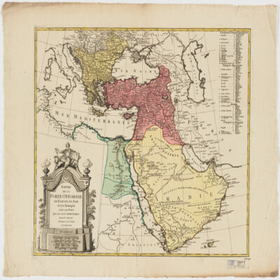
23. Empire de la Porte ottomane en Europe, en Asie et en Afrique avec les pays qui lui sont tributaires Creator: Lotter Brothers (Firm) (Creator) Date: Date Issued: [1790?] Language: French Geographic region: Place of Production: gw, Germany, AugsburgMiddle EastTurkeyEurope, SouthernAfrica, North Extent: 1 map : hand col. ; 47 x 55 cm.
24. Exercices de lecture d'arabe littéral, à l'usage de ceux qui commencent l'étude de cette langue. [Suivi de] Alphabet arabe, turk et persan, à l'usage de l'imprimerie orientale et française / [par Jean-Joseph Marcel] Creator: Marcel, Jean-Joseph (1776-1854) Date: 1797 Language: French