Some vols. issued semiannually.\r\nDescription based on: Bd. 14 (1956).\r\nPublication suspended, 1945-1955.\r\nEnglish, French, German or Italian.\r\nVols. 1-13:1 published by the institute under its earlier name: Deutsches Institut für Ägyptische Altertumskunde in Kairo.\r\nVols. 14-61 Published by Otto Harrassowitz.
Some vols. issued semiannually.\r\nDescription based on: Bd. 14 (1956).\r\nPublication suspended, 1945-1955.\r\nEnglish, French, German or Italian.\r\nVols. 1-13:1 published by the institute under its earlier name: Deutsches Institut für Ägyptische Altertumskunde in Kairo.\r\nVols. 14-61 Published by Otto Harrassowitz.
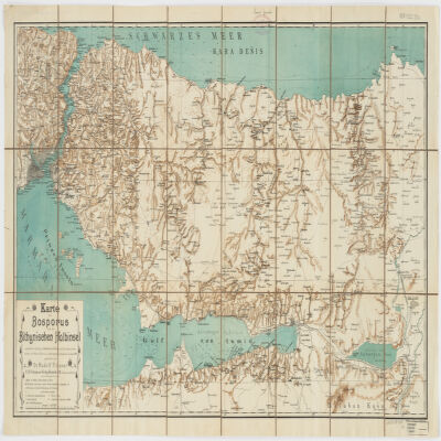
nach älteren Quellen (v. Moltke, Heinrich Kiepert, Brit. Admiralitätskarten, v. d. Goltz, v. Diest u.a.) und eigenen Aufnahmen im Jahre 1900 gezeichnet von Rudolf Fitzner ; Hof. Stdr. v. J. G. Tiedmann Nachf.Relief shown by hachures. Depths shown by contours.Includes index.Electronic reproduction. Cambridge, Mass. : Harvard College Library Digital Imaging Group, 2009. (Open Collections Program at Harvard University. Islamic Heritage Project). Copy digitized: Map Coll (Pusey) : MAP-LC G7433.I8 1900 .F5.Electronic reproduction. Cambridge, Mass. : Harvard Geospatial Library, 2014. Georeferenced image for use in a GIS.
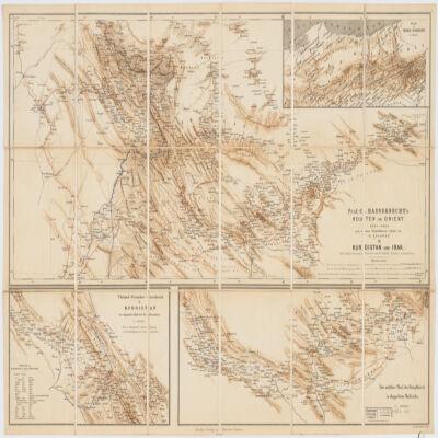
nach dessen Originalskizzen redigirt von H. Kiepert.Covers portions of Turkey, Iraq and Iran.Relief shown by shading.Prime meridian: Greenwich and Paris.Inset: Route in Nord-Persien (Scale 1:600,000).Ancillary maps: Türkish-Persischer Grenzbezirk in Kurdistan im doppelten Maβstab der Hauptkarte (Scale 1:400,000), Der mittlere Theil der Hauptkarte im doppeltem Maβstabe (Scale 1:400,000)."Druck v. Fr. Schwabe, Berlin".Includes lexicon German-Turkish-Persian.In German with place names in Turkish and Persian.Electronic reproduction. Cambridge, Mass. : Harvard College Library Digital Imaging Group, 2009. (Open Collections Program at Harvard University. Islamic Heritage Project). Copy digitized: XXXXX Library: [call no.].
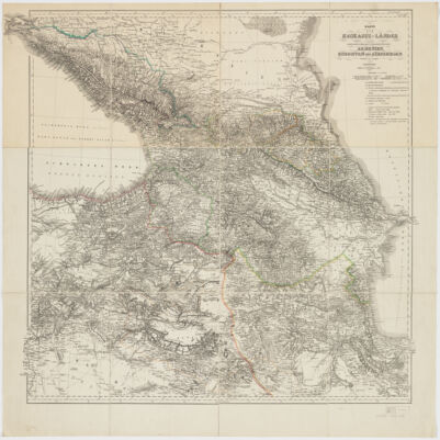
bearbeitet und gezeichnet von H. Kiepert.Relief shown by hachures and spot heights.Prime meridian Greenwich and Ferro.Colored in outline.Electronic reproduction. Cambridge, Mass. : Harvard College Library Digital Imaging Group, 2009. (Open Collections Program at Harvard University. Islamic Heritage Project). Copy digitized: Map Coll (Pusey) : MAP-LC G7120 1854 .K5.Electronic reproduction. Cambridge, Mass. : Harvard Geospatial Library, 2009. Georeferenced image for use in a GIS.