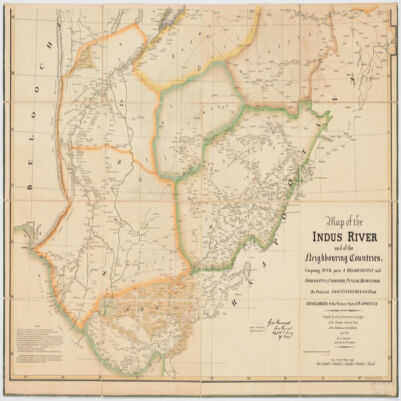
1. Map of the Indus River and the neighbouring countries, sheet 1comprising Sind, parts of Beloochistan and Afghanistan, Cashmeer, Punjab, Bhawulpoor, the protected Sikh States, Bickaneer and Jaysulmeer; & the Western Parts of Rajpootana Creator: Graham, J. (المنشئ) Date: Date Issued: Jan. 1835 Language: Indonesian Geographic region: Place of Production: ii, India, CalcuttaIndus River RegionAfghanistanPunjab (India) Extent: 1 map on 2 sheets : col. ; 147 x 104 cm, sheets 77 x 109 cm and 79 x 117 cm.
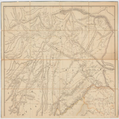
2. Map of the Indus River and the neighbouring countries, sheet 2comprising Sind, parts of Beloochistan and Afghanistan, Cashmeer, Punjab, Bhawulpoor, the protected Sikh States, Bickaneer and Jaysulmeer; & the Western Parts of Rajpootana Creator: Graham, J. (المنشئ) Date: Date Issued: Jan. 1835 Language: Indonesian Geographic region: Place of Production: ii, India, CalcuttaIndus River RegionAfghanistanPunjab (India) Extent: 1 map on 2 sheets : col. ; 147 x 104 cm, sheets 77 x 109 cm and 79 x 117 cm.
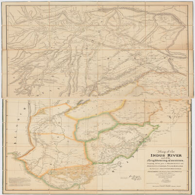
3. Map of the Indus River and the neighbouring countries, stitchedcomprising Sind, parts of Beloochistan and Afghanistan, Cashmeer, Punjab, Bhawulpoor, the protected Sikh States, Bickaneer and Jaysulmeer; & the Western Parts of Rajpootana Creator: Graham, J. (المنشئ) Date: Date Issued: Jan. 1835 Language: Indonesian Geographic region: Place of Production: ii, India, CalcuttaIndus River RegionAfghanistanPunjab (India) Extent: 1 map on 2 sheets : col. ; 147 x 104 cm, sheets 77 x 109 cm and 79 x 117 cm.