"The first comprehensive description of ancient and modern Egyptcompiled by the 165 members of the Institut de l'Egypte established by Napoleon to accompany his expedition to Egypt in 1798-1801. This exhaustive survey of all aspects of ancient and modern life in Egypt was carried out under the supervision of the mathematician Gaspard Mongethe appointed President of the new Institute (of which Napoleon was Vice-President)."
Fihrist: Union Catalogue of Manuscripts from the Islamicate WorldRecord origin: "Description based on the Bodleian Library's public card index of Arabic manuscripts with additional enhancements by the OCIMCO project team. Image descriptions based in part on CarboniRecord origin: S. (1988)Record origin: Il Kitab al-bulhan di Oxford."
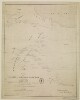
Distinctive Features:Relief shown by hachures.Routes indicated by dotted lines.Inscriptions:On the recto in the bottom right-hand corner signature ‘John Garstin Surveyor Genls. Office Fort William 1811’.Labels:On the recto in the lower centre black ink oval stamp ‘E.I. COMP’S LIBRARY’.1 map sheetMaterials:Pen and ink on paperDimensions:501 x 400 mm, on sheet 545 x 450 mm
Correspondence and other papers relating to purchases for and the maintenance of the Bahrain Political Agency gardens. The file’s correspondents include: the Political Agent (Major Cyril Charles Johnson Barrett; Captain Charles Geoffrey Prior; Lieutenant-Colonel Percy Gordon Loch); representatives of the Manama Municipality (writing in Arabic); horticultural suppliers, including Pestonjee P Pocha & Sons of Poona, Bliss & Company of Karachi, and Imperial Chemical Industries (India) Limited; Nora Loch (née Dalyell), wife of the Political Agent Percy Gordon Loch.Papers relating to purchases made for a range of supplies (including flower and vegetable seeds, bulbs, plants, garden implements, manure, artificial fertilizer, labour) include advertisements, order forms, bills, receipts, and price lists, and correspondence confirming arrangements for the delivery of items to Bahrain. Papers relating to the maintenance of the garden include correspondence relating to the recruitment of a gardener from India, water and electricity supply, and damage to a garden water tank.Other items in the file include:a price list of flower and vegetable seeds supplied by Sutton & Sons and imported by Bliss & Company of Karachi, received at the Political Agency in September 1930 (ff 58-59);an illustrated brochure of Christmas gifts for gardens, produced by Pestonjee P Pocha & Sons, received at the Political Agency in November 1930 (ff 73-80);a brochure advertising new year offers for roses, cannas, chrysanthemums, fruit trees and other plants, produced by Pestonjee P Pocha & sons (ff 115-120);a price list of Arthur Yates & Company’s Australian flower and vegetable seeds for 1935/1936, supplied by Bliss & Company (f 172);correspondence dated 1936/1937 between Nora Loch and the curator at the Royal Botanical Gardens in Edinburgh, Roland Edgar Cooper, concerning seeds and plants for the Agency Garden (ff 226-229, f 232);a list of cuttings and seeds planted in the Political Agency garden. The list is divided into sources (the Royal Botanical Gardens in Edinburgh, local sources, the House of the Binns in Scotland, and Egypt), and arranged alphabetically by each plant’s Latin name, with date (presumably the planting date) and notes on its location (ff 183-225);garden diary entries for the period 16 October 1935 to 6 January 1936 (ff 238-239) and flower lists for the period 13 October 1936 to 21 March 1937 (ff 242-245). These lists are interspersed amongst correspondence sent by Nora Loch, and are likely to have been compiled by her.1 file (314 folios)The file’s contents are arranged in approximate chronological order, from the earliest item at the front to the latest at the end. The file notes at the end of the file (ff 302-315) mirror the chronological arrangement.Foliation: the main foliation sequence (used for referencing) commences at the front cover with 1, and terminates at the inside back cover with 316; these numbers are written in pencil, are circled, and are located in the top right corner of the recto side of each folio. Two additional foliation sequences are also present in parallel between ff 4-301, and ff 302-311; these numbers are also written in pencil, but are not circled.
Binding: The volume is bound in a European binding of pasteboards covered with brown leather. The covers have frames formed of two gold fillets. There are five cords on the spine, with two gold fillets either side of each cord. The pastedowns are modern and are blank except for annotations of the manuscript number and a bookplate for St John’s College and E Libris Coll. Di. Jo. Bapt. Oxon. on the back pastedown.Contents note: Annotations by John Greaves (1602-1652), Savilian Professor of Astronomy (1643-8), fols. 12a/b, 13a, 15a.Contents note: Contents described on fol. iii b: Collatio Mensium Arabicorum, Cophticorum, Græcorum, & Judaicorum. Vide pag. 1. ubi habes hunc titulum doctissimi ipsius Pocockij a later hand has crossed out the last two words, and written in pencil: Gul. Laudi manuscriptum. Nec non Tabulæ quædam Astronomicæ. Omnia imperfecta. In margine passim occurrunt Notæ Viri eruditissimi Joan. Grauij, Prof. Astronom. Sauil.Contents note: In item 1, it is evident from numbers placed on each table that there were originally 23, though tables 5–6, 14–15, and 20–1 are now missing and two tables carry the number ‘9’. Ff. 10a/b, 11a and 17b are blank except for frames formed of two black-inked lines.Dimensions: 21.3 × 13.9 (text area 17 × 10.2) cm.Hand: Both items written in a variable (small to medium) Arabic naskh using black and red inks. The text area has not been ruled, but the tables are divided into rows and columns. The texts are written in tables whose cells are delineated by red- and black-inked lines; occasionally there is writing around the perimeter of the table.Layout: The text area has not been ruled, but the tables are divided into rows and columns. The texts are written in tables whose cells are delineated by red and black inked lines; occasionally there is writing around the perimeter of the table. Lines per page vary.Origin note: "No copyist's signature or date(s) or place(s) of copying."Record origin: "Descriptions abbreviated from Emilie Savage-SmithRecord origin: A descriptive Catalogue of Oriental Manuscripts at St John's CollegeRecord origin: Oxford (Oxford: Oxford University PressRecord origin: 2005)Record origin: Entries. Nos. 4 and 10Record origin: pp. 19-22Record origin: 41-2."
"\r\n\r\nShows boundariesroadsriverstowns and principal settlements. Also shows a part of the Arabian Peninsula. Publication date from the library's acquisition form.\r\n\r\n"Scale: No scale given
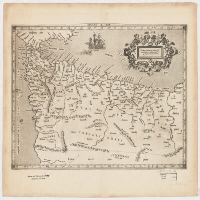
[Gerardus Mercator].Attributed to Mercator.Also covers a portion of Southern Spain.Relief shown pictorially.In an ornamental cartouche: "Medius meridianus J6, reliqui ad hunc inclinati funt pro ratione parallelorum 29 BL 34 ad circulum maximum."Probably originally published with a second map entitled "Africae II Tab." covering Malta, Sicily, Sardinia, Tunisia and Libya.Includes note and index on verso.Electronic reproduction. Cambridge, Mass. : Harvard College Library Digital Imaging Group, 2009. (Open Collections Program at Harvard University. Islamic Heritage Project). Copy digitized: Map Coll (Pusey) : MAP-LC G8220 1619 .A4.
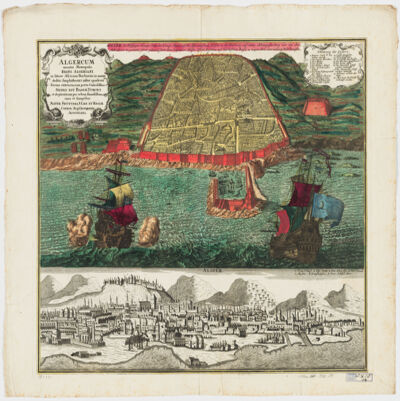
cura et sumptibus Matth. Seutteri.Birds-eye view.Appears in: Atlas novus sive tabulæ geographicæ totius orbis faciem, partes, imperia, regna et provincias exhibentes / exactissima cura iuxta recentissimas observation Matthaeo Seutter, [1745?]. Vol.1, map No. 137.Includes a close-up view of Algiers and index.In German with a title in Latin.Electronic reproduction. Cambridge, Mass. : Harvard College Library Digital Imaging Group, 2009. (Open Collections Program at Harvard University. Islamic Heritage Project). Copy digitized: Map Coll (Pusey) : MAP-LC G8244.A6 A3 1730 .S4.
cum interpretatione latina & notis Thomae Erpenii.In Arabic and Latin.Electronic reproduction. Cambridge, Mass. : Harvard College Library Digital Imaging Group, 2008. (Open Collections Program at Harvard University. Islamic Heritage Project).
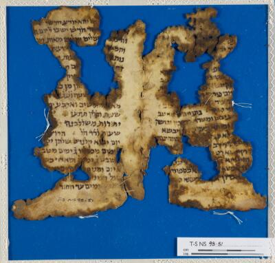
Calendrical work mentioning the months of January (יונאריס) and February (פבראריס) and the calends (קלנדס).Condition: torn, holes, stainedLayout: 16-21 lines
dressée au Service géographique de l'armée.Covers also a portion of Algeria and Libya.Relief shown by shading and spot heights. Depth shown by isolines.In French with place names in Arabic and Latin in Latin script.Table of Contents: "Tunisie (800 000e) Flle Nord" -- "Tunisie (800 000e) Flle Sud".
dressée au Service géographique de l'armée.Covers also a portion of Algeria and Libya.Relief shown by shading and spot heights. Depth shown by isolines.In French with place names in Arabic and Latin in Latin script.Table of Contents: "Tunisie (800 000e) Flle Nord" -- "Tunisie (800 000e) Flle Sud".
dressée au Service géographique de l'armée.Covers also a portion of Algeria and Libya.Relief shown by shading and spot heights. Depth shown by isolines.In French with place names in Arabic and Latin in Latin script.Table of Contents: "Tunisie (800 000e) Flle Nord" -- "Tunisie (800 000e) Flle Sud".
Binding: Late 18th or early 19th century English vellum with blind-tooled borders; sewn onto three supports; with shelfmark on the spine.Contents: Hebrew words with Latin and Greek translations, and biblical references.Contents note: Inscribed on pastedown of upper board: ‘Anno 1779. Ludovicus Bagot, Aedis Christi Decanus dono dedit librum hunc ab Edvardo Griffith A.B. ex aula Magdaleno, Oxon. conscriptum Edv. Griffith obiit 1753’.Dimensions: 223 x 174 x 28 mm (size of binding); ca. 216-199 x 165 mm (size of leaf)Hand: 18th century hand.Layout: Text written in two columns, from left to right; first column is in Hebrew, arranged alphabetically and the second column is in Latin, with biblical references and translations in Latin and Greek.Record origin: Description based on Kitchin, Catalogus Codicum MSS. qui in Bibliotheca Aedis Christi apud Oxonienses (Oxford: Clarendon Press, 1867).
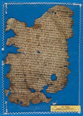
Leaf from Saʿadya’s commentary on the book of Isaiah. There is an owner’s note, written in large outline script, for Jacob he-Ḥaver b. Job. A smaller and neater colophon identifies the work and states that it was purchased by Josiah he-Ḥaver b. Aaron ‘the distinguished’ son of Josiah, Av. He bought it in the year that he was ordained into the Jerusalem Academy (בישיבה הקדושה ישיבת הצבי), the year 4791 of the Era of Creation (= 1030-1031 CE), in Acre. Later, presumably during the First Crusade, the book fell into Crusader hands and someone, holding the book upside down as if it was a Western book, wrote a short note in Latin identifying its contents: ‘[interpre]tacio esaya prophete’. During their conquest of the Holy Land, the Crusaders took not only prisoners for ransom but also Jewish books and scrolls. This leaf is presumably from one of the books that passed through Crusader hands but was eventually sold back to the Jewish community.Condition: Torn, holes, rubbedLayout: 43 lines (recto); 14 lines (verso)
Venundantur per Gerardum et Leonardum Valk, cum Priv.Covers Croatia, Bosnia and Hercegovina, Serbia, Montenegro and portions of Italy, Albania, Greece, Macedonia and Hungary.Relief shown pictorially.Includes note.In Latin with place names in ItalianElectronic reproduction. Cambridge, Mass. : Harvard College Library Digital Imaging Group, 2009. (Open Collections Program at Harvard University. Islamic Heritage Project). Copy digitized: Map Coll (Pusey) MAP-LC G6800 1710 .V3.
Library copy has dated inscription " Ex libris francisci, Sauuin Medici 1666" on title page. Library copy lacks volume 3. This book was acquired with the generous support of the Margaret R. King and Margaret W. Harmon Endowment.
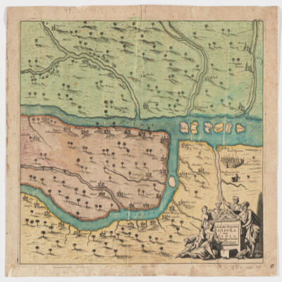
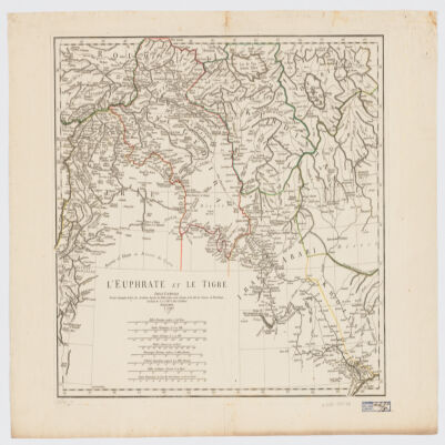
[Olfert Dapper].Covers a portion of southeastern Iraq where the Euphrates and the Tigris Rivers converge.Relief shown pictorially.From: Naukeurige beschryving van Asie: behelsende de gewesten van Mesopotamie, Babylonie, Assyrie, Anatolie, of Klein Asie: beneffens eene volkome beschrijving van gansch gelukkigh, woest, en petreesch of steenigh Arabie / Olfert Dapper. 1680.Oriented with North toward the left.Electronic reproduction. Cambridge, Mass. : Harvard College Library Digital Imaging Group, 2009. (Open Collections Program at Harvard University. Islamic Heritage Project). Copy digitized: Map Coll (Pusey) : MAP-LC G7610 1680 .D3.
The manuscript comprises a Hebrew and Aramaic dictionary, followed by a glossary that presents further etymological parallels with related Oriental languages. Its method of helping students to identify the root letters of Hebrew words, was first developed by German Orientalist, and Professor of Hebrew, at the University of Leipzig, Elias Hutter (ca. 1553-1609).Contents: A manuscript note by Samuel Rolles Driver (i). Title page (ii). Preface (iii-vii). Dictionary (1r-43v). Glossary (44r-50v).Extent: ff 52. 440 x 280 x 20 mm.Hand: 18th century English hand.Binding: 18th century half-calf over paper boards.Additional information: Rahel Fronda, Jewish Books and their Christian Readers: Christ Church Connections (Oxford: Christ Church, 2017), pp. 92-96.
dressé sur les plus nouvelles relations a l'usage de Monseigneur le Duc de Bourgogne par son tres humble et tres obeissant serviteur H. Iaillot.Electronic reproduction. Cambridge, Mass. : Harvard College Library Digital Imaging Group, 2009. (Open Collections Program at Harvard University. Islamic Heritage Project). Copy digitized: Map Coll (Pusey) : MAP-LC G7430 1696 .J3.
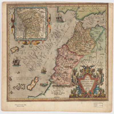
describebat Abrah. Ortelius.Covers Morocco and portions of Spain, West Sahara and Algeria.Relief shown pictorially and by hachures.Prime meridian: Ferro.Inset of West Africa: Congi Regni Christiani, in Africa, nova descriptio / Auctore Filippo Pigafetta (Scale [ca. 1:11,000,000]).Includes ill. in col.On verso: two texts entitled "Fessae et Marocchi Regna" and "Congi Regnum"."Cum Imp. Reg. et Brabantiæ privilegio decennali".Electronic reproduction. Cambridge, Mass. : Harvard College Library Digital Imaging Group, 2009. (Open Collections Program at Harvard University. Islamic Heritage Project). Copy digitized: Map Coll (Pusey) : MAP-LC G8230 1595 .O7.
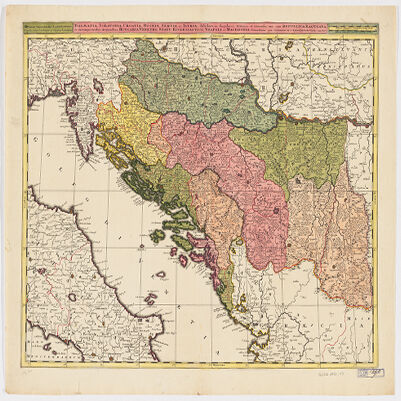
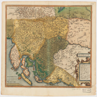
Ioan. Sambucus Ortelio suo, S Mitto hanc quòque tabellam qua nesessaria confinia Pannoniæ declarantur, fluviorum et aliquot locorum situs Hirschvogelii recte mutaui, Angelini autem studio plurima adieci, et inualla correxi, vt parum quis si cum Hirschvogelig hæc conjugat desiderarit si qui errores sint, dies certiora docebit.Covers Istria, Croatia, Slovenia, Bosnia and Herzegovina, Dalmatia, and part of Hungary.Relief shown pictorially."Cum temporaris et Regis Maiestaris Privilegio".Includes ill.On verso: text entitled "Illyricvm".
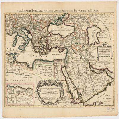
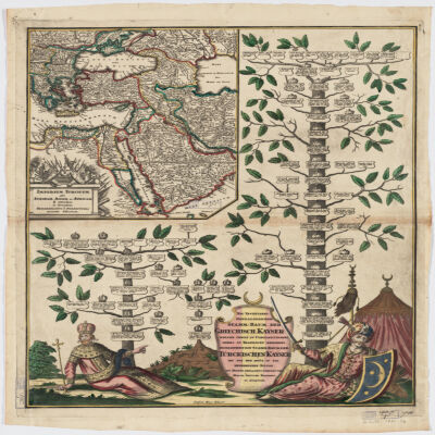
Covers Libya, Egypt, Sudan, the Arabian Peninsula, Lebanon, Syria, Iraq, Iran, the Balkan Peninsula, Turkey, Greece, Armenia, Azerbaijan and portions of Ethiopia and Russia.Relief shown by hachures and pictorially.Colored in outline.Inset: Neu Inventiert. Genealogischer Stamm-Baum Der Griechisch. Kaÿser Welche Theils Zu Constantinopel Theils Zu Trapezunt Residiret : desgleichen ein StammBaum Der Türckischen Kaÿser Bis Auf Den Heüt Zu Tag Regierenden Sultan / ins Kupfer gebracht u. verlegt von Matth. Seütter.Includes ill.In German and Latin.Electronic reproduction. Cambridge, Mass. : Harvard College Library Digital Imaging Group, 2009. (Open Collections Program at Harvard University. Islamic Heritage Project). Copy digitized: XXXXX Library: [call no.].
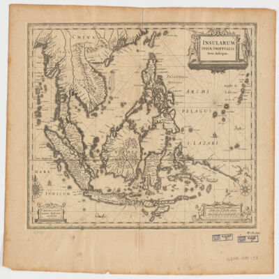
Ioannis Ianssonius.Covers Sumatra, Java, Borneo, Suwalesi, the Philippines, Papua New Guinea and portions of China, Burma and Malaysia.Relief shown pictorially.Includes ill.Electronic reproduction. Cambridge, Mass. : Harvard College Library Digital Imaging Group, 2009. (Open Collections Program at Harvard University. Islamic Heritage Project). Copy digitized: Map Coll (Pusey) : MAP-LC G8000 1650 .J3.Electronic reproduction. Cambridge, Mass. : Harvard Geospatial Library, 2009. Georeferenced image for use in a GIS.
cum interpretatione Latina & scholiis Iosephi Scaligeri et Thomæ Erpenii.Arabic title transliterated.BM 6:309 notes edited by Thomas Erpenius.Signatures: *⁴A-Q⁴ (Q4 blank, present).In Arabic and Latin.
Binding: "17th century calf over pasteboards; pairs of blind fillets towards outer edges of boards; pairs of blind fillets forming inner rectangle design; blind stamped corner pieces (fleurons) to inner rectangle; sewn on five supports; raised bands and blind tooling on spine; blind roll tooled decoration around board edges; evidence of chaining (staple holes towards edge of lower fore-edge); text block edges sprinkled red; spine labelled '16'."Contents: MER.119.f.17(1): ʿAbd al-Wahhāb ibn Ibrāhīm Zanjānī, Kitāb al-tasrīf taʼlīf al-Shaykh al-Imāmi, (pp. i-120). MER.119.f.17(2): Isaac ben Joseph Karo, Zeh sefer Toldot Yitsḥaḳ : perush ʻal ha-Torah (ff. 1a-99b). MER.119.f.17(3): Midrash ha-neʿelam on Genesis (ff. 1a-58b). Responsa concerning tsitsit and Shabbat (ff. 59a-60a). Zohar on certain parashiyot, mostly from the book of Leviticus (ff. 60b-111b). Colophon (f. 111b). Zohar on parashat Pekude; Heikhalot (ff. 112a-124b).Dimensions: 266 x 200 x 59 mm (size of binding); ca. 260 x 198 mm (size of leaf).Record origin: Description provided by Rahel Fronda.
par le Sr. d'Anville ; Guill. De La Haye.Covers portions of Jordan, Syria, Lebanon, Israel, Turkey, Azerbaijan, Iran and Iraq.Relief shown pictorially.Colored in outline.In French with many place names also given with Roman-era Latin forms.Electronic reproduction. Cambridge, Mass. : Harvard College Library Digital Imaging Group, 2009. (Open Collections Program at Harvard University. Islamic Heritage Project). Copy digitized: XXXXX Library: [call no.].Electronic reproduction. Cambridge, Mass. : Harvard Geospatial Library, 2009. Georeferenced image for use in a GIS.
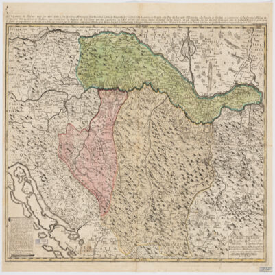
le très humble et très obéissant serviteur Étienne Briffaut.Shows battle places with date.Covers Bosnia and Hercegovina, and portions of Hungary, Croatia, Albania and Yugoslavia.Relief shown pictorially.Includes note and ill."Je me suis fais un devoir de Publier cette Carte Sous les Auspices de V. E. étant un des Capitaines de S.M.I. et Cath. qui entend mieux le métier de la guerre et qui marche sur les mêmes principes que le défunt Prince Eugène ayant le flême et la prudence come elle en a donné des preuves par les dernières campagnes d'Italie, et en dernier lieu par le combat contre les trouppes ottomanes arrivé le 28 7bris 737 près de la rivière de la Timock et suis avec un parfait dévouement et un pronfond respect de V. E.".In French with place names and a legend in Latin.Electronic reproduction. Cambridge, Mass. : Harvard College Library Digital Imaging Group, 2009. (Open Collections Program at Harvard University. Islamic Heritage Project). Copy digitized: XXXXX Library: [call no.].
Binding: Late 18th or early 19th century English vellum; sewn onto four supports; with shelfmark on the spine.Contents: Hebrew words with Latin translations and biblical references.Contents note: Inscribed on pastedown of upper board: ‘Donum Joannis Morris, S.T.P. hujusce Aedis Canonici, & Linguae Hebraeae Prof. Reg.’.Dimensions: 340 x 213 x 107 mm (size of binding); 326 x 201 mm (size of leaf).Hand: 18th century hand.Layout: Text written in two columns, from left to right; first column is in Hebrew, arranged alphabetically and the second column is in Latin, with biblical references and translations in Latin and Greek.Record origin: Description based on Kitchin, Catalogus Codicum MSS. qui in Bibliotheca Aedis Christi apud Oxonienses (Oxford: Clarendon Press, 1867).
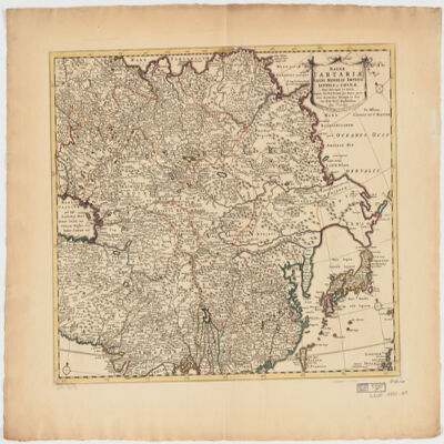
ampliss viri D. N. Witsen pro majori parte aliis auctoribus excerpta et dita per F. de Witt.Covers Northeastern Russia, China, Korea, Japan, Turkestan, Kazakhstan, Tajikistan, Kyrgyzstan, Mongolia, Uzbekistan, Afghanistan, Pakistan and portions of Iran, India, China.Relief shown pictorially.Colored in outline.Appears in: Atlas nouveau contenant toutes les parties du monde, où sont exactement marqués les empires, monarchies, royaumes, états républiques &c; le tout recueilli par les meilleurs géographes. [1683-1761]. Vol. 8, map no.108.In Latin with place names in Russian, Turkish, Persian and Arabic in Latin script.Electronic reproduction. Cambridge, Mass. : Harvard College Library Digital Imaging Group, 2009. (Open Collections Program at Harvard University. Islamic Heritage Project). Copy digitized: Map Coll (Pusey) : MAP-LC G7400 1725 .W5.
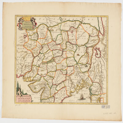
Per F. de Witt.Covers portions of the Middle East, South and Central Asia and China.Appears in: Atlas Major / Frederick de Wit. 1707. Map no. 118.Relief shown pictorially.Includes ill.Electronic reproduction. Cambridge, Mass. : Harvard College Library Digital Imaging Group, 2009. (Open Collections Program at Harvard University. Islamic Heritage Project). Copy digitized: Map Coll (Pusey) : MAP-LC G7625 1707 .W5.
delineatus a C. Niebuhr ; Defehrt sc..Covers the Red Sea Coast including parts of Djibouti.North oriented toward the right.Relief shown pictorially. Depths shown by shading.Includes index."Tab: XX".Electronic reproduction. Cambridge, Mass. : Harvard College Library Digital Imaging Group, 2009. (Open Collections Program at Harvard University. Islamic Heritage Project). Copy digitized: Map Coll (Pusey) : MAP-LC G5687.R3 1772 .N5.