"The first comprehensive description of ancient and modern Egyptcompiled by the 165 members of the Institut de l'Egypte established by Napoleon to accompany his expedition to Egypt in 1798-1801. This exhaustive survey of all aspects of ancient and modern life in Egypt was carried out under the supervision of the mathematician Gaspard Mongethe appointed President of the new Institute (of which Napoleon was Vice-President)."
Fihrist: Union Catalogue of Manuscripts from the Islamicate WorldRecord origin: "Description based on the Bodleian Library's public card index of Arabic manuscripts with additional enhancements by the OCIMCO project team. Image descriptions based in part on CarboniRecord origin: S. (1988)Record origin: Il Kitab al-bulhan di Oxford."
Distinctive Features:Relief shown by hachures.Routes indicated by dotted lines.Inscriptions:On the recto in the bottom right-hand corner signature ‘John Garstin Surveyor Genls. Office Fort William 1811’.Labels:On the recto in the lower centre black ink oval stamp ‘E.I. COMP’S LIBRARY’.1 map sheetMaterials:Pen and ink on paperDimensions:501 x 400 mm, on sheet 545 x 450 mm
Correspondence and other papers relating to purchases for and the maintenance of the Bahrain Political Agency gardens. The file’s correspondents include: the Political Agent (Major Cyril Charles Johnson Barrett; Captain Charles Geoffrey Prior; Lieutenant-Colonel Percy Gordon Loch); representatives of the Manama Municipality (writing in Arabic); horticultural suppliers, including Pestonjee P Pocha & Sons of Poona, Bliss & Company of Karachi, and Imperial Chemical Industries (India) Limited; Nora Loch (née Dalyell), wife of the Political Agent Percy Gordon Loch.Papers relating to purchases made for a range of supplies (including flower and vegetable seeds, bulbs, plants, garden implements, manure, artificial fertilizer, labour) include advertisements, order forms, bills, receipts, and price lists, and correspondence confirming arrangements for the delivery of items to Bahrain. Papers relating to the maintenance of the garden include correspondence relating to the recruitment of a gardener from India, water and electricity supply, and damage to a garden water tank.Other items in the file include:a price list of flower and vegetable seeds supplied by Sutton & Sons and imported by Bliss & Company of Karachi, received at the Political Agency in September 1930 (ff 58-59);an illustrated brochure of Christmas gifts for gardens, produced by Pestonjee P Pocha & Sons, received at the Political Agency in November 1930 (ff 73-80);a brochure advertising new year offers for roses, cannas, chrysanthemums, fruit trees and other plants, produced by Pestonjee P Pocha & sons (ff 115-120);a price list of Arthur Yates & Company’s Australian flower and vegetable seeds for 1935/1936, supplied by Bliss & Company (f 172);correspondence dated 1936/1937 between Nora Loch and the curator at the Royal Botanical Gardens in Edinburgh, Roland Edgar Cooper, concerning seeds and plants for the Agency Garden (ff 226-229, f 232);a list of cuttings and seeds planted in the Political Agency garden. The list is divided into sources (the Royal Botanical Gardens in Edinburgh, local sources, the House of the Binns in Scotland, and Egypt), and arranged alphabetically by each plant’s Latin name, with date (presumably the planting date) and notes on its location (ff 183-225);garden diary entries for the period 16 October 1935 to 6 January 1936 (ff 238-239) and flower lists for the period 13 October 1936 to 21 March 1937 (ff 242-245). These lists are interspersed amongst correspondence sent by Nora Loch, and are likely to have been compiled by her.1 file (314 folios)The file’s contents are arranged in approximate chronological order, from the earliest item at the front to the latest at the end. The file notes at the end of the file (ff 302-315) mirror the chronological arrangement.Foliation: the main foliation sequence (used for referencing) commences at the front cover with 1, and terminates at the inside back cover with 316; these numbers are written in pencil, are circled, and are located in the top right corner of the recto side of each folio. Two additional foliation sequences are also present in parallel between ff 4-301, and ff 302-311; these numbers are also written in pencil, but are not circled.
Binding: The volume is bound in a European binding of pasteboards covered with brown leather. The covers have frames formed of two gold fillets. There are five cords on the spine, with two gold fillets either side of each cord. The pastedowns are modern and are blank except for annotations of the manuscript number and a bookplate for St John’s College and E Libris Coll. Di. Jo. Bapt. Oxon. on the back pastedown.Contents note: Annotations by John Greaves (1602-1652), Savilian Professor of Astronomy (1643-8), fols. 12a/b, 13a, 15a.Contents note: Contents described on fol. iii b: Collatio Mensium Arabicorum, Cophticorum, Græcorum, & Judaicorum. Vide pag. 1. ubi habes hunc titulum doctissimi ipsius Pocockij a later hand has crossed out the last two words, and written in pencil: Gul. Laudi manuscriptum. Nec non Tabulæ quædam Astronomicæ. Omnia imperfecta. In margine passim occurrunt Notæ Viri eruditissimi Joan. Grauij, Prof. Astronom. Sauil.Contents note: In item 1, it is evident from numbers placed on each table that there were originally 23, though tables 5–6, 14–15, and 20–1 are now missing and two tables carry the number ‘9’. Ff. 10a/b, 11a and 17b are blank except for frames formed of two black-inked lines.Dimensions: 21.3 × 13.9 (text area 17 × 10.2) cm.Hand: Both items written in a variable (small to medium) Arabic naskh using black and red inks. The text area has not been ruled, but the tables are divided into rows and columns. The texts are written in tables whose cells are delineated by red- and black-inked lines; occasionally there is writing around the perimeter of the table.Layout: The text area has not been ruled, but the tables are divided into rows and columns. The texts are written in tables whose cells are delineated by red and black inked lines; occasionally there is writing around the perimeter of the table. Lines per page vary.Origin note: "No copyist's signature or date(s) or place(s) of copying."Record origin: "Descriptions abbreviated from Emilie Savage-SmithRecord origin: A descriptive Catalogue of Oriental Manuscripts at St John's CollegeRecord origin: Oxford (Oxford: Oxford University PressRecord origin: 2005)Record origin: Entries. Nos. 4 and 10Record origin: pp. 19-22Record origin: 41-2."
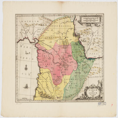
"\r\n\r\nShows boundariesroadsriverstowns and principal settlements. Also shows a part of the Arabian Peninsula. Publication date from the library's acquisition form.\r\n\r\n"Scale: No scale given
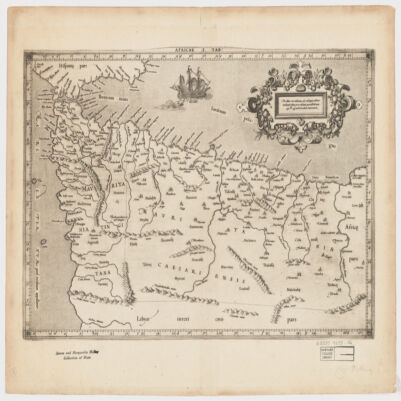
[Gerardus Mercator].Attributed to Mercator.Also covers a portion of Southern Spain.Relief shown pictorially.In an ornamental cartouche: "Medius meridianus J6, reliqui ad hunc inclinati funt pro ratione parallelorum 29 BL 34 ad circulum maximum."Probably originally published with a second map entitled "Africae II Tab." covering Malta, Sicily, Sardinia, Tunisia and Libya.Includes note and index on verso.Electronic reproduction. Cambridge, Mass. : Harvard College Library Digital Imaging Group, 2009. (Open Collections Program at Harvard University. Islamic Heritage Project). Copy digitized: Map Coll (Pusey) : MAP-LC G8220 1619 .A4.
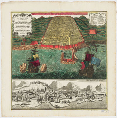
cura et sumptibus Matth. Seutteri.Birds-eye view.Appears in: Atlas novus sive tabulæ geographicæ totius orbis faciem, partes, imperia, regna et provincias exhibentes / exactissima cura iuxta recentissimas observation Matthaeo Seutter, [1745?]. Vol.1, map No. 137.Includes a close-up view of Algiers and index.In German with a title in Latin.Electronic reproduction. Cambridge, Mass. : Harvard College Library Digital Imaging Group, 2009. (Open Collections Program at Harvard University. Islamic Heritage Project). Copy digitized: Map Coll (Pusey) : MAP-LC G8244.A6 A3 1730 .S4.
cum interpretatione latina & notis Thomae Erpenii.In Arabic and Latin.Electronic reproduction. Cambridge, Mass. : Harvard College Library Digital Imaging Group, 2008. (Open Collections Program at Harvard University. Islamic Heritage Project).
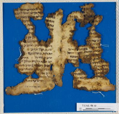
Calendrical work mentioning the months of January (יונאריס) and February (פבראריס) and the calends (קלנדס).Condition: torn, holes, stainedLayout: 16-21 lines
dressée au Service géographique de l'armée.Covers also a portion of Algeria and Libya.Relief shown by shading and spot heights. Depth shown by isolines.In French with place names in Arabic and Latin in Latin script.Table of Contents: "Tunisie (800 000e) Flle Nord" -- "Tunisie (800 000e) Flle Sud".
dressée au Service géographique de l'armée.Covers also a portion of Algeria and Libya.Relief shown by shading and spot heights. Depth shown by isolines.In French with place names in Arabic and Latin in Latin script.Table of Contents: "Tunisie (800 000e) Flle Nord" -- "Tunisie (800 000e) Flle Sud".
dressée au Service géographique de l'armée.Covers also a portion of Algeria and Libya.Relief shown by shading and spot heights. Depth shown by isolines.In French with place names in Arabic and Latin in Latin script.Table of Contents: "Tunisie (800 000e) Flle Nord" -- "Tunisie (800 000e) Flle Sud".
Binding: Late 18th or early 19th century English vellum with blind-tooled borders; sewn onto three supports; with shelfmark on the spine.Contents: Hebrew words with Latin and Greek translations, and biblical references.Contents note: Inscribed on pastedown of upper board: ‘Anno 1779. Ludovicus Bagot, Aedis Christi Decanus dono dedit librum hunc ab Edvardo Griffith A.B. ex aula Magdaleno, Oxon. conscriptum Edv. Griffith obiit 1753’.Dimensions: 223 x 174 x 28 mm (size of binding); ca. 216-199 x 165 mm (size of leaf)Hand: 18th century hand.Layout: Text written in two columns, from left to right; first column is in Hebrew, arranged alphabetically and the second column is in Latin, with biblical references and translations in Latin and Greek.Record origin: Description based on Kitchin, Catalogus Codicum MSS. qui in Bibliotheca Aedis Christi apud Oxonienses (Oxford: Clarendon Press, 1867).
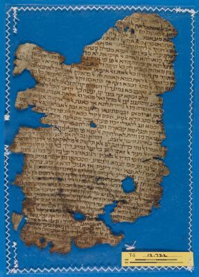
Leaf from Saʿadya’s commentary on the book of Isaiah. There is an owner’s note, written in large outline script, for Jacob he-Ḥaver b. Job. A smaller and neater colophon identifies the work and states that it was purchased by Josiah he-Ḥaver b. Aaron ‘the distinguished’ son of Josiah, Av. He bought it in the year that he was ordained into the Jerusalem Academy (בישיבה הקדושה ישיבת הצבי), the year 4791 of the Era of Creation (= 1030-1031 CE), in Acre. Later, presumably during the First Crusade, the book fell into Crusader hands and someone, holding the book upside down as if it was a Western book, wrote a short note in Latin identifying its contents: ‘[interpre]tacio esaya prophete’. During their conquest of the Holy Land, the Crusaders took not only prisoners for ransom but also Jewish books and scrolls. This leaf is presumably from one of the books that passed through Crusader hands but was eventually sold back to the Jewish community.Condition: Torn, holes, rubbedLayout: 43 lines (recto); 14 lines (verso)
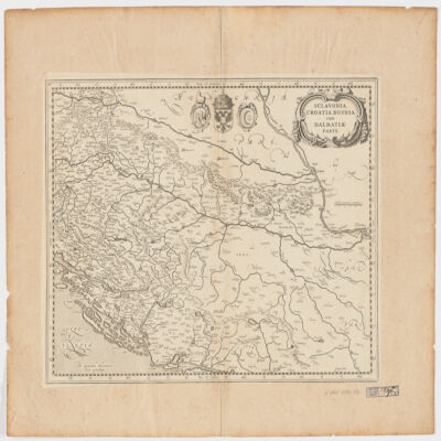
Venundantur per Gerardum et Leonardum Valk, cum Priv.Covers Croatia, Bosnia and Hercegovina, Serbia, Montenegro and portions of Italy, Albania, Greece, Macedonia and Hungary.Relief shown pictorially.Includes note.In Latin with place names in ItalianElectronic reproduction. Cambridge, Mass. : Harvard College Library Digital Imaging Group, 2009. (Open Collections Program at Harvard University. Islamic Heritage Project). Copy digitized: Map Coll (Pusey) MAP-LC G6800 1710 .V3.
Library copy has dated inscription " Ex libris francisci, Sauuin Medici 1666" on title page. Library copy lacks volume 3. This book was acquired with the generous support of the Margaret R. King and Margaret W. Harmon Endowment.
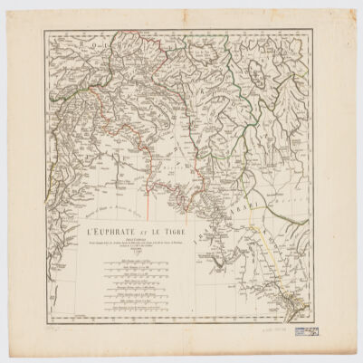
[Olfert Dapper].Covers a portion of southeastern Iraq where the Euphrates and the Tigris Rivers converge.Relief shown pictorially.From: Naukeurige beschryving van Asie: behelsende de gewesten van Mesopotamie, Babylonie, Assyrie, Anatolie, of Klein Asie: beneffens eene volkome beschrijving van gansch gelukkigh, woest, en petreesch of steenigh Arabie / Olfert Dapper. 1680.Oriented with North toward the left.Electronic reproduction. Cambridge, Mass. : Harvard College Library Digital Imaging Group, 2009. (Open Collections Program at Harvard University. Islamic Heritage Project). Copy digitized: Map Coll (Pusey) : MAP-LC G7610 1680 .D3.
The manuscript comprises a Hebrew and Aramaic dictionary, followed by a glossary that presents further etymological parallels with related Oriental languages. Its method of helping students to identify the root letters of Hebrew words, was first developed by German Orientalist, and Professor of Hebrew, at the University of Leipzig, Elias Hutter (ca. 1553-1609).Contents: A manuscript note by Samuel Rolles Driver (i). Title page (ii). Preface (iii-vii). Dictionary (1r-43v). Glossary (44r-50v).Extent: ff 52. 440 x 280 x 20 mm.Hand: 18th century English hand.Binding: 18th century half-calf over paper boards.Additional information: Rahel Fronda, Jewish Books and their Christian Readers: Christ Church Connections (Oxford: Christ Church, 2017), pp. 92-96.
dressé sur les plus nouvelles relations a l'usage de Monseigneur le Duc de Bourgogne par son tres humble et tres obeissant serviteur H. Iaillot.Electronic reproduction. Cambridge, Mass. : Harvard College Library Digital Imaging Group, 2009. (Open Collections Program at Harvard University. Islamic Heritage Project). Copy digitized: Map Coll (Pusey) : MAP-LC G7430 1696 .J3.
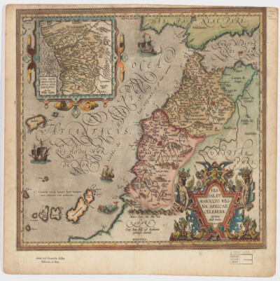
describebat Abrah. Ortelius.Covers Morocco and portions of Spain, West Sahara and Algeria.Relief shown pictorially and by hachures.Prime meridian: Ferro.Inset of West Africa: Congi Regni Christiani, in Africa, nova descriptio / Auctore Filippo Pigafetta (Scale [ca. 1:11,000,000]).Includes ill. in col.On verso: two texts entitled "Fessae et Marocchi Regna" and "Congi Regnum"."Cum Imp. Reg. et Brabantiæ privilegio decennali".Electronic reproduction. Cambridge, Mass. : Harvard College Library Digital Imaging Group, 2009. (Open Collections Program at Harvard University. Islamic Heritage Project). Copy digitized: Map Coll (Pusey) : MAP-LC G8230 1595 .O7.
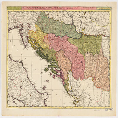
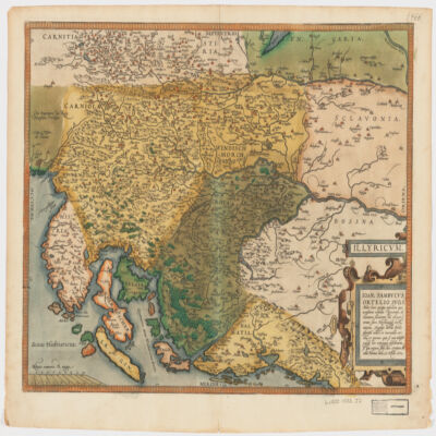
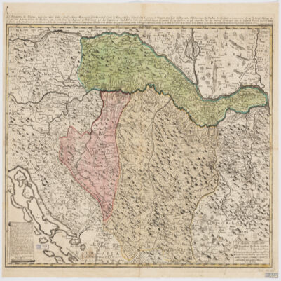
Ioan. Sambucus Ortelio suo, S Mitto hanc quòque tabellam qua nesessaria confinia Pannoniæ declarantur, fluviorum et aliquot locorum situs Hirschvogelii recte mutaui, Angelini autem studio plurima adieci, et inualla correxi, vt parum quis si cum Hirschvogelig hæc conjugat desiderarit si qui errores sint, dies certiora docebit.Covers Istria, Croatia, Slovenia, Bosnia and Herzegovina, Dalmatia, and part of Hungary.Relief shown pictorially."Cum temporaris et Regis Maiestaris Privilegio".Includes ill.On verso: text entitled "Illyricvm".
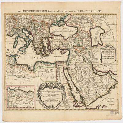
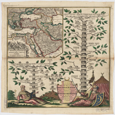
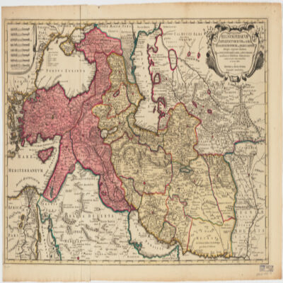
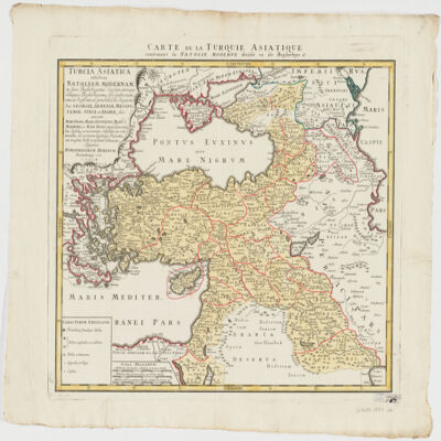
Covers Libya, Egypt, Sudan, the Arabian Peninsula, Lebanon, Syria, Iraq, Iran, the Balkan Peninsula, Turkey, Greece, Armenia, Azerbaijan and portions of Ethiopia and Russia.Relief shown by hachures and pictorially.Colored in outline.Inset: Neu Inventiert. Genealogischer Stamm-Baum Der Griechisch. Kaÿser Welche Theils Zu Constantinopel Theils Zu Trapezunt Residiret : desgleichen ein StammBaum Der Türckischen Kaÿser Bis Auf Den Heüt Zu Tag Regierenden Sultan / ins Kupfer gebracht u. verlegt von Matth. Seütter.Includes ill.In German and Latin.Electronic reproduction. Cambridge, Mass. : Harvard College Library Digital Imaging Group, 2009. (Open Collections Program at Harvard University. Islamic Heritage Project). Copy digitized: XXXXX Library: [call no.].
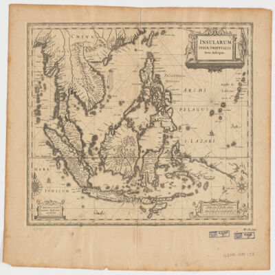
Ioannis Ianssonius.Covers Sumatra, Java, Borneo, Suwalesi, the Philippines, Papua New Guinea and portions of China, Burma and Malaysia.Relief shown pictorially.Includes ill.Electronic reproduction. Cambridge, Mass. : Harvard College Library Digital Imaging Group, 2009. (Open Collections Program at Harvard University. Islamic Heritage Project). Copy digitized: Map Coll (Pusey) : MAP-LC G8000 1650 .J3.Electronic reproduction. Cambridge, Mass. : Harvard Geospatial Library, 2009. Georeferenced image for use in a GIS.
cum interpretatione Latina & scholiis Iosephi Scaligeri et Thomæ Erpenii.Arabic title transliterated.BM 6:309 notes edited by Thomas Erpenius.Signatures: *⁴A-Q⁴ (Q4 blank, present).In Arabic and Latin.
Binding: "17th century calf over pasteboards; pairs of blind fillets towards outer edges of boards; pairs of blind fillets forming inner rectangle design; blind stamped corner pieces (fleurons) to inner rectangle; sewn on five supports; raised bands and blind tooling on spine; blind roll tooled decoration around board edges; evidence of chaining (staple holes towards edge of lower fore-edge); text block edges sprinkled red; spine labelled '16'."Contents: MER.119.f.17(1): ʿAbd al-Wahhāb ibn Ibrāhīm Zanjānī, Kitāb al-tasrīf taʼlīf al-Shaykh al-Imāmi, (pp. i-120). MER.119.f.17(2): Isaac ben Joseph Karo, Zeh sefer Toldot Yitsḥaḳ : perush ʻal ha-Torah (ff. 1a-99b). MER.119.f.17(3): Midrash ha-neʿelam on Genesis (ff. 1a-58b). Responsa concerning tsitsit and Shabbat (ff. 59a-60a). Zohar on certain parashiyot, mostly from the book of Leviticus (ff. 60b-111b). Colophon (f. 111b). Zohar on parashat Pekude; Heikhalot (ff. 112a-124b).Dimensions: 266 x 200 x 59 mm (size of binding); ca. 260 x 198 mm (size of leaf).Record origin: Description provided by Rahel Fronda.
par le Sr. d'Anville ; Guill. De La Haye.Covers portions of Jordan, Syria, Lebanon, Israel, Turkey, Azerbaijan, Iran and Iraq.Relief shown pictorially.Colored in outline.In French with many place names also given with Roman-era Latin forms.Electronic reproduction. Cambridge, Mass. : Harvard College Library Digital Imaging Group, 2009. (Open Collections Program at Harvard University. Islamic Heritage Project). Copy digitized: XXXXX Library: [call no.].Electronic reproduction. Cambridge, Mass. : Harvard Geospatial Library, 2009. Georeferenced image for use in a GIS.
le très humble et très obéissant serviteur Étienne Briffaut.Shows battle places with date.Covers Bosnia and Hercegovina, and portions of Hungary, Croatia, Albania and Yugoslavia.Relief shown pictorially.Includes note and ill."Je me suis fais un devoir de Publier cette Carte Sous les Auspices de V. E. étant un des Capitaines de S.M.I. et Cath. qui entend mieux le métier de la guerre et qui marche sur les mêmes principes que le défunt Prince Eugène ayant le flême et la prudence come elle en a donné des preuves par les dernières campagnes d'Italie, et en dernier lieu par le combat contre les trouppes ottomanes arrivé le 28 7bris 737 près de la rivière de la Timock et suis avec un parfait dévouement et un pronfond respect de V. E.".In French with place names and a legend in Latin.Electronic reproduction. Cambridge, Mass. : Harvard College Library Digital Imaging Group, 2009. (Open Collections Program at Harvard University. Islamic Heritage Project). Copy digitized: XXXXX Library: [call no.].
Binding: Late 18th or early 19th century English vellum; sewn onto four supports; with shelfmark on the spine.Contents: Hebrew words with Latin translations and biblical references.Contents note: Inscribed on pastedown of upper board: ‘Donum Joannis Morris, S.T.P. hujusce Aedis Canonici, & Linguae Hebraeae Prof. Reg.’.Dimensions: 340 x 213 x 107 mm (size of binding); 326 x 201 mm (size of leaf).Hand: 18th century hand.Layout: Text written in two columns, from left to right; first column is in Hebrew, arranged alphabetically and the second column is in Latin, with biblical references and translations in Latin and Greek.Record origin: Description based on Kitchin, Catalogus Codicum MSS. qui in Bibliotheca Aedis Christi apud Oxonienses (Oxford: Clarendon Press, 1867).
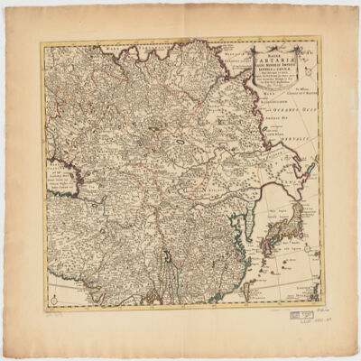
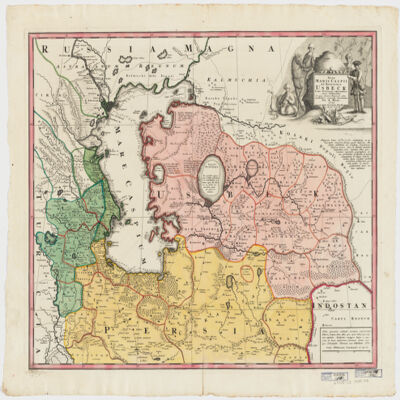
ampliss viri D. N. Witsen pro majori parte aliis auctoribus excerpta et dita per F. de Witt.Covers Northeastern Russia, China, Korea, Japan, Turkestan, Kazakhstan, Tajikistan, Kyrgyzstan, Mongolia, Uzbekistan, Afghanistan, Pakistan and portions of Iran, India, China.Relief shown pictorially.Colored in outline.Appears in: Atlas nouveau contenant toutes les parties du monde, où sont exactement marqués les empires, monarchies, royaumes, états républiques &c; le tout recueilli par les meilleurs géographes. [1683-1761]. Vol. 8, map no.108.In Latin with place names in Russian, Turkish, Persian and Arabic in Latin script.Electronic reproduction. Cambridge, Mass. : Harvard College Library Digital Imaging Group, 2009. (Open Collections Program at Harvard University. Islamic Heritage Project). Copy digitized: Map Coll (Pusey) : MAP-LC G7400 1725 .W5.
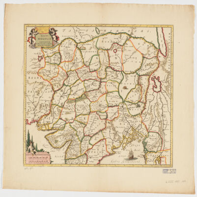
Per F. de Witt.Covers portions of the Middle East, South and Central Asia and China.Appears in: Atlas Major / Frederick de Wit. 1707. Map no. 118.Relief shown pictorially.Includes ill.Electronic reproduction. Cambridge, Mass. : Harvard College Library Digital Imaging Group, 2009. (Open Collections Program at Harvard University. Islamic Heritage Project). Copy digitized: Map Coll (Pusey) : MAP-LC G7625 1707 .W5.
delineatus a C. Niebuhr ; Defehrt sc..Covers the Red Sea Coast including parts of Djibouti.North oriented toward the right.Relief shown pictorially. Depths shown by shading.Includes index."Tab: XX".Electronic reproduction. Cambridge, Mass. : Harvard College Library Digital Imaging Group, 2009. (Open Collections Program at Harvard University. Islamic Heritage Project). Copy digitized: Map Coll (Pusey) : MAP-LC G5687.R3 1772 .N5.
li-Abī al-Qāsim Maḥmūd ibn ʻUmar al-Zamakhsharī.Title on added t.p.: Samachscharii lexicon arabicum persicum.لأبي القاسم محمود بن عمر الزمخشري.Electronic reproduction. Cambridge, Mass. : Harvard College Library Digital Imaging Group, 2009. (Open Collections Program at Harvard University. Islamic Heritage Project). Copy digitized: Widener Library: OL 22423.9.
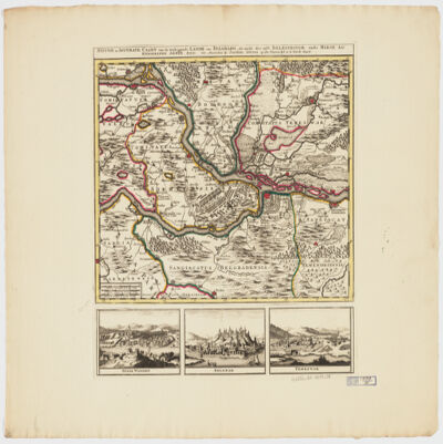
by Joachim Ottens.Relief shown pictorially.Colored in outline.Shows military points of interest related to the Battle of Belgrade, 1717.Includes ill. and views: Peter Wardein -- Belgrad -- Temeswar.Place names in Latin.Electronic reproduction. Cambridge, Mass. : Harvard College Library Digital Imaging Group, 2009. (Open Collections Program at Harvard University. Islamic Heritage Project). Copy digitized: Map Coll (Pusey) MAP-LC G6854.B5 1717 .O8.
in qua itinera Regia et alia notabiliora accurate denotantur per A. Maas ; reductio mappæ haijus a majore in hanc monirem formam facta est per Iohannem Petrum van Ghelen.Covers portions of Uzbekistan, Kazakhstan, Afghanistan, Turkmenistan, Russia, Azerbaijan and Iran.Relief shown pictorially. Depth shown by soundings.Includes notes and ill."Cum Priv. S. C. M.".Electronic reproduction. Cambridge, Mass. : Harvard College Library Digital Imaging Group, 2009. (Open Collections Program at Harvard University. Islamic Heritage Project). Copy digitized: Map Coll (Pusey) : MAP-LC G5692.C3 1735 .M3.
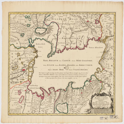
immenso labore et maximis sumptibus facta, atque ex autographo in lucem edita per Reinerum Ottens geographum Amstelaedam ; Iacob Keyser sculp.Covers portions of Iran, Turkmenistan, Kazakhstan, Russia and Azerbaijan.Relief shown pictorially. Depth shown by soundings.Oriented with North to the left.Colored in outline.Includes ill.Appears in: Atlas maior cum generales omnium totius orbis regnorum rerumpubl. atque insularum tum particulares praecipuarum in iis provinciarum ducatuum comitatuum ceterarum que minorum regionum ac divisionum tabulas geographicas continens ex optimis ac novissimis quibusque variorum autorum tabulis collectus et eleganti ordine dispositus / Reiner Ottens. [1641-1729]. Vol. 7, map No. 23.In Latin with a publication note in Dutch and place names in Greek, Russian, Persian, Arabic, and Turkish in Latin script.Electronic reproduction. Cambridge, Mass. : Harvard College Library Digital Imaging Group, 2009. (Open Collections Program at Harvard University. Islamic Heritage Project). Copy digitized: XXXXX Library: [call no.].
Binding: Early 17th century sprinkled calf over pasteboards, with blind-tooled double panels; sewn onto four supports; shelfmark on the spine; text block edges stained blue.Contents note: With a Latin introduction by Paul Fagius, a Latin endorsement by Georg Voegelin, a Hebrew poem, and Hebrew prefaces with Latin translation. Many contemporary marginal annotations: extensive manuscript notes on flyleaves in Latin and Hebrew by Thomas Wakefield.Decoration: Woodcut initial words and printer’s device. Simple floral designs.Dimensions: 229mm (height) × 174mm (width) × 50mm (depth).Layout: Hebrew and Latin on opposite pages. With printed marginal notes. Hebrew type resembling square Ashkenazi script.
par E. Andriveau ; gravé le trait et les montagnes par Gérin, les écritures par P. Rousset, les eaux par Mme Fontaine.Covers portions of Israel, Jordan, Syria and Lebanon.Relief shown by hachures. Depth shown by sounding and isolines.Insets: [Sinai] (Scale [ca. 1:2,600,000]) -- Golfe de Suez -- [Cross section of the Palestine from the source of the Jordan to the Red Sea] -- [Panoramic view of the mountains of Palestine] -- Jérusalem d'après le plan de G. Williams (Scale [ca. 1:80,000])."No. 18"."Atlas usuel No. 23"."Atlas universel No.36".Includes notes and index.In French with place names in Latin, Arabic and Hebrew in Latin script.Electronic reproduction. Cambridge, Mass. : Harvard Geospatial Library, 2009. Georeferenced image for use in a GIS.
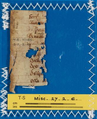
Verses from the Latin narrative poem, Ilias Latina, composed by Baebius Italicus in the 1st century CE. This fragment contains verses 461-475 (recto) and 482-495 (verso), covering events in the fifth book of the Iliad.Condition: Badly tornLayout: 13 lines (recto); 14 lines + marginalia (verso)
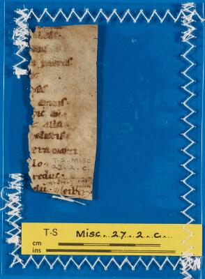
Verses from the Latin narrative poem, Ilias Latina, composed by Baebius Italicus in the 1st century CE. Together with T-S Misc. 27e (with which this fragment joins), this fragment contains verses 423-434 (recto) and 442-454 (verso), covering events in the fifth book of the Iliad.Condition: Badly tornLayout: 12 lines (recto); 10 lines (verso)
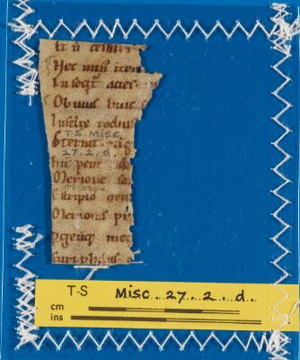
Verses from the Latin narrative poem, Ilias Latina, composed by Baebius Italicus in the 1st century CE. Together with T-S Misc. 27d (with which this fragment joins), this fragment contains verses 423-434 (recto) and 442-454 (verso), covering events in the fifth book of the Iliad.Condition: Badly tornLayout: 10 lines
cum triplici versione Latina, & scholijs Thomae Erpenii, cujus & alphabetum Arabicum praemittitur.Signatures: A-S⁴ (signatures printed in Arabic sequence).Title and imprint within an architectural woodcut border incorporating the printer's device; printer's device at end.Interlinear word-for-word translation, with a free marginal translation by Erpenius, followed by the version of Robert of Chester and Hermannus Dalmata, and notes.In Arabic and Latin.cum triplici versione Latina, & scholijs Thomae Erpenii, cujus & alphabetvm Arabicvm praemittitur.Electronic resource. Leiden : IDC, 2010. (Early Western Korans ; EPK-18)Electronic reproduction. Cambridge, Mass. : Harvard College Library Digital Imaging Group, 2008. (Open Collections Program at Harvard University. Islamic Heritage Project).
Fihrist: Union Catalogue of Manuscripts from the Islamicate WorldRecord origin: "Manuscript description based on the Bodleian Library's public card index of Arabic manuscripts with additional enhancements by the OCIMCO project team."
Binding: 18th century English red morocco with gold-tooled borders and fleurons; sewn onto six supports; gold-tooling on the spine; text block edges sprinkled red.Dimensions: 312 × 204 × 65 mm (size of binding); 302 × 187 mm (size of leaf)Hand: 18th century English hand.Layout: "Text is written in two columnsLayout: from left to right (mostly on verso sides of each leaf); first column is in HebrewLayout: arranged alphabetically and the second column is in LatinLayout: with examples of the same word form in HebrewLayout: AramaicLayout: Greek and Ge'ezLayout: and includes biblical references."Record origin: Description based on Kitchin, Catalogus Codicum MSS. qui in Bibliotheca Aedis Christi apud Oxonienses (Oxford: Clarendon Press, 1867).
Binding: 18th century English red morocco with gold-tooled borders and fleurons; sewn onto six supports; gold-tooling on the spine; text block edges sprinkled red.Dimensions: 311 × 216 × 36 mm (size of binding); 304 × ca. 187-204 mm (size of leaf).Hand: 18th century English hand.Layout: "Text is written in two columnsLayout: from left to right; first column is in HebrewLayout: arranged alphabetically and the second column is in LatinLayout: with examples of the same word form in HebrewLayout: AramaicLayout: Greek and Ge'ezLayout: and includes biblical references."Record origin: Description based on Kitchin, Catalogus Codicum MSS. qui in Bibliotheca Aedis Christi apud Oxonienses (Oxford: Clarendon Press, 1867).
ex variis observationibus in lucem edita a Reinero et Josua Ottens.Covers the Middle East, Southern Caucasus, Central Asia and portions of Egypt, the Arabian Peninsula and Southeastern Europe.Relief shown pictorially.Electronic reproduction. Cambridge, Mass. : Harvard College Library Digital Imaging Group, 2009. (Open Collections Program at Harvard University. Islamic Heritage Project). Copy digitized: Map Coll (Pusey) : MAP-LC G7420 1730 .R2.
per Gerardum Mercatorem cum privilegio.Apperas in: Nieuwen atlas ofte werelt-beschrijvinge vertoonende de voornaemste rijckenende lande des gheheelen aerdt-bodems / Ioannem Ianssonium. 1657-[87]. Vol. 1, map No. 138.Covers Slovenia, Croatia, Bosnia and Hercegovina and portions of Hungary, Serbia and Montenegro.Relief shown pictorially.Includes coats of arms.Electronic reproduction. Cambridge, Mass. : Harvard College Library Digital Imaging Group, 2009. (Open Collections Program at Harvard University. Islamic Heritage Project). Copy digitized: Map Coll (Pusey) : MAP-LC G6800 1630 .M4.
This manuscript contains al-Makkūdī (d. 1404)'s commentary on one of the most popular Arabic grammatical works, the Alfīyah of Ibn Mālik, Muḥammad ibn ʻAbd Allāh, d. 1274 Ibn Mālik (d. 1274) . The exceptional importance of this manuscript resides in the fact that it has preserved marginalia and commentaries written by its owner, Erpenius, Thomas, 1584-1624 Thomas Erpenius , Dutch Orientalist and author of the first scientific grammar of Arabic written in Europe. The Arabic text of al-Makkūdī is interleaved with folios containing Erpenius annotations, which provide important information about the way Arabic was studied in Modern Europe, and also about Erpenius' relationship with the Morisco Aḥmad ibn Qāsim al-Ḥājarī, with whom he read al-Makkūdī's work.Layout: 28 lines to the pageScript: Main text in Maghribi script in brown ink. Marginal notes in European nask, brown ink.
Fihrist: Union Catalogue of Manuscripts from the Islamicate WorldRecord origin: "Manuscript description based on the Bodleian Library's public card index of Arabic manuscripts with additional enhancements by the OCIMCO project team."
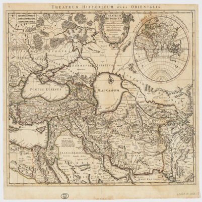
Auctore Guillelmo Delisle.Covers the Middle East, Southeastern Europe and portions of Russia, Egypt, India and the Arabian Peninsula."100."Colored in outline.Inset map: Supplementum theatro historico.Relief shown pictorially.Engraved on woven paper.Includes note.Electronic reproduction. Cambridge, Mass. : Harvard College Library Digital Imaging Group, 2009. (Open Collections Program at Harvard University. Islamic Heritage Project). Copy digitized: Map Coll (Pusey) : MAP-LC G5671.S1 1759 .L5.
Distribución: 2 col. La mayor parte del volumen tiene 22 ó 23 líneas por página. Otras varían mucho de número.Material: PapelTinta: MarrónIncipit: أَبتَالَوُّ conformeExplicit: تَشَقََقَ rasgar scindereLugar de escritura: No constaCopista: No constaColofón: No constaCaracterísticas especiales: Texto vocalizado parcialmenteIlustración: NoIlustraciones: En algunos números se numeran las líneas de cada folioTipo de cuaderno: 44 cuads.: 4 bifolios, 17 biniones, 10 terniones, 6 cuaterniones, 1 quinión, 5 sextniones, 1 septnión y 1 folio suelto, que se van alternando.Deterioros: Buen estado del texto. Acortamiento del pergamino de la encuadernación. Los cuadernos se han despegado de la encuadernación y algunos se han descosido. Se aprecian manchas y degradaciones de la tinta que no afectan al texto.H en blanco: 19 folios en blanco más el verso de 16 folios siguiendo la orientación le lectura latina.H dañadas, mutiladas, sueltas: 1 H suelta : folio 268H faltan o añadidas: H Faltan: Según la anotación de la portada: “le faltan las primeras 30 hojas, constaba de 280”; si atendemos a esta anotación, el manuscrito debería de tener 250 folios, sin embargo, vemos que el volumen consta actualmente de 268 folios, lo cual, esta anotación, o no es correcta o al volumen le fueron añadidos posteriormente 18 folios. No obstante, hay que tener en cuenta la foliación original del manuscrito para calcular de forma aproximada cuantos folios le faltan. De este modo vemos que hay un salto de foliación entre el 78 y el 100, esto supone que faltan 11 folios (del 79 al 99) de la primera centena; mientras que, entre los folios 100 y 200 de la segunda centena hay 105 folios en lugar de 100; y finalmente, vemos que del folio 200 hasta el último hay 84 folios. Con estos cálculos se llega a dos conclusiones. La primera, que el volumen tenía al menos 289 folios, de los cuales 11 numerados de la primera centena se habrían perdido y algunos de la segunda centena pertenecerían a la tercera centena porque probablemente se encuadernaron mal; de ahí la explicación del porque no se sigue ningún orden alfabético. La segunda, que el manuscrito tuviera más de 289 folios.Foliación: Tiene dos foliaciones: una original en tinta marrón y la otra moderna a lápiz siguiendo ambas la orientación de lectura latina. La foliación original comprende desde el folio 1 al 78 más dos folio que llevan: uno el dígito 100 y que corresponde al 79 foliado a lápiz, y otro el dígito 200 y que corresponde al 184 foliado a lápiz. Probablemente en origen fueran foliados los 100 primeros folios y después se numeraría el folio 100 de cada centena. La foliación moderna cuyo autor se desconoce, abarca desde el folio 79 al 268.Reclamos: NoSign. cuad.: NoPautado: No se aprecia pautado alguno. Líneas de justificación.Filigrana: Escudo cuyo interior alberga tres cruces unidas mediante una línea horizontal por la parte inferior Escudo en forma de corazón con una cruz dentro y otras tres que lo rematan en su parte superior, mientras que en su parte inferior se leen en mayúscula las letras “GBD”. Tres circunferencias dispuestas una encima de otra, la primera vacía, la del centro contiene la letra “D” en mayúscula, y la tercera las letras “BG” también en mayúscula. Las tres circunferencias son rematadas en su parte superior por una cruz. El dígito 10.Signatura antigua: VOL. XVII ; A-5-17 ; Caja C-21Anotaciones: Anotaciones marginales muy esporádicas, generalmente para añadir una explicación de la raíz del vocablo en cuestión o bien para corregir su traducción al latín o al castellano. En la portada en tinta marrón se registra el texto siguiente: “le faltan las primeras 30 hojas, constaba de 280”. En el lomo junto con el título en tinta marrón (“Thesauso Arabicae”) hay dos etiquetas pegadas una que contiene el digito 3 y la otra la antigua signatura (Caja C-21). La misma signatura a lápiz aparece en el interior de la tapa encima de unos números tachados. Los rótulos de cada letra siempre van precedidos de “Lra.” como abreviatura de “letra”. Antiguo sello de la Biblioteca Universitaria de Granada en algunos folios del volumen, además de la firma del autor del volumen al final de algunos cuadernos.Contenido: Thesauro Arabicae (Nota: la obra contiene dos vocabularios bien diferenciados entre sí, que son: 1º) Vocabulario arábigo-castellano, que abarca los folios del 1 al 86v y el 2º) Vocabulario arábigo-latino, que abarca los folios del 87r-268v.)Pergamino
ex novissimis subsidiis ac relationibus ad normam legitimae proiectionis in usum belli praesentis delineata impensis homannianorum heredum.Covers Eastern Turkey, Cyprus, Syria, Lebanon, Israel, Jordan, Iraq, Armenia, Azerbaijan, Georgia and portions of Egypt, the Arabian Peninsula, Iran, Greece and Russia.Relief shown pictorially.In Latin with a title in French.Electronic reproduction. Cambridge, Mass. : Harvard Geospatial Library, 2009. Georeferenced image for use in a GIS.Electronic reproduction. Cambridge, Mass. : Harvard College Library Digital Imaging Group, 2009. (Open Collections Program at Harvard University. Islamic Heritage Project). Copy digitized: Map Coll (Pusey) : MAP-LC G7420 1771 .H6.
arabicè olim exarata à Georgio Elmacino ... et latinè reddita operâ ac studio Thomae Erpenii. Accedit & Roderici Ximenez ... Historia Arabum, longè accuratius, quam antè, è manuscripto codice expressa.Arabic text and Latin translation in parallel columns.Electronic reproduction. Cambridge, Mass. : Harvard College Library Digital Imaging Group, 2008. (Open Collections Program at Harvard University. Islamic Heritage Project).
Comprend : De Carchemis oppidi situ et historia antiquissima, accedunt nonnulla de Pedaso homerica - Sur la stèle de l'intronisation trouvée au Djebel-Barkal - Essai sur la Stèle du Songe - Le papyrus médical d'Ebers, p. p. Ebers et Stern - Brugsch, Histoire d'Egypte sous les pharaons, additions et corrections à l'Histoire d'Egypte sous les pharaons, histoire d'Egypte sous les pharaons, traduite en anglais par Smith - De quelques navigations des égyptiens sur les côtes de la mer Erythrée - Fragment d'un commentaire sur le livre II d'Hérodote (II, XXVIII) - Procès verbal de l'ouverture des momies de Ramsès II et Ramsès III - Bulletin critique de la religion égyptienne, le livre des morts - Bulletin critique de la religion égyptienne, le rituel du sacrifice funéraire - La Syrie avant l'invasion des Hébreux d'après les monuments égyptiens, conférence faite à la Société des études juives, le 26 mars 1887Numérisé par le partenaireAppartient à l’ensemble documentaire : BbLevt0Avec mode texte
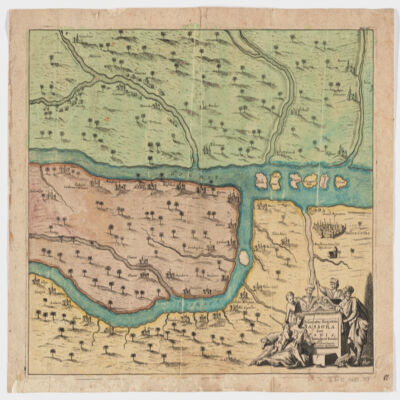
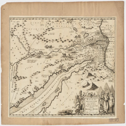
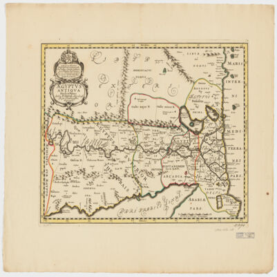
Covers Egypt and portions of Libya, Israel and Jordan, including the Red Sea and the Nile.Relief shown pictorially.Oriented with North to the right.Includes ill.Appears in: Nieuwen atlas ofte werelt-beschrijvinge vertoonende de voornaemste rijckenende landen des gheheelen aerdt-bodems; vermeerdert met veel schoone landt-kaerten, nieuwelijcks uptgegeven (...) / Ioannem Iansonium, 1657-87. Vol. 3, map No. 96.In Latin with place names in Hebrew and Arabic in Latin script.
authore P. Duval Abbeviliense Regis Christianissimi geographo.Shows political divisions.Covers also a portion of Libya.Relief shown pictorially.Oriented with North to the right.Includes a note in a decorative cartouche: "A Monsieur Monsieur Doviat Sgr. de Montreuille, Con.er du Roy, et Maistre Ordinaire en sa Chambre des Comptes Par son Très humble et obéisant Serviteur P. Duval Géographe de sa Maiesté".In Latin with a note in French.Electronic reproduction. Cambridge, Mass. : Harvard College Library Digital Imaging Group, 2009. (Open Collections Program at Harvard University. Islamic Heritage Project). Copy digitized: Map Coll (Pusey) : MAP-LC G8300 1652 .D8.
Binding: 16th century sprinkled calf over paper boards, with blind-tooling; sewn onto six supports, with raised bands; fragments of early English manuscripts used as binding waste; marbled text block edges; evidence of chaining (staple holes towards edge of lower fore-edge); blind-tooling on spine; spine title in gilt.Contents: The text of the biblical books of Former Prophets, that is the books of Joshua, Judges, 1-2 Samuel and 1-2 Kings, with David Kimhi’s commentary (ff. 1a-156b).Contents note: Some marginal manuscript annotations in Latin, Hebrew and English by Thomas Wakefield.Decoration: With woodcut initial word panels.Dimensions: 324mm (height) x 228mm width x 49mm (depth).Layout: Biblical text in the centre in a larger square script and Kimhi’s commentary in a semi-cursive script surrounding it. Hebrew types resembling square and semi-cursive scripts.
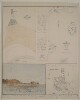
Imprint:London, T. Pettitt & Co. Litho.Distinctive Features:Map in the upper left:'North end of Hormúz Island shewing site of ancient towns &c.’.Map in the upper right:'Map shewing the position of Hormúz Island with reference to the Persian Coast and the other old European settlements in the vicinity. From actual survey by A.W. Stiffe, late Lieut. R.N.'View in the lower left:'Portuguese fort on Hormúz Island, old minaret on the left.'Map in the lower right:'Isld. of Harmúz or Ormus. Bird's-eye view of Hormúz from “Astley's" collection’Includes Latin text in the upper centre: ‘A ESTA SEPHEDESI MAORO 13 DEFAR IAE DESVAMOL HERE HERDROS FALECEOEILEA A.Z. DEABRILDE BOIEILA A8DEE EVRODE B03’. And below: ‘SEPVTRA DE AMTONO CO REA E DE SEVS IR DEIROS FALE SEO AOS 17 DE IANE IRO DE 1591 ANNOS’. With skull and crossbones at the bottom.Inscriptions:On recto, top margin in the right-hand corner: ‘Geographical Magazine’ and 'April 1874'.3 maps and 1 view on 1 sheetDimensions:260 x 240 mm or smaller, on sheet 430 x 570 mm
Binding: European binding (repaired) of pasteboards covered with mottled brown leather. The covers have a central frame of four fillets with scallops interspersed with palmettes; at each corner of the central frame are large blind-stamped flower-heads. The covers also have narrow outer frames of two fillets. The spine (five cords) is undecorated. The pastedowns and endpapers (fols. ii–ii, iii–iv) are modern. The numeral 91 has been inked on the fore-edge of the manuscript.Contents note: Ff. 10a-12a are incomplete; f. 12b is blank; some of the tables ff. 48a-49a are incomplete; f.50a has been added by a later hand. Ff. 4b-5a, 12b and 93b-94a contain pencilled notes in several languages by John Greaves (1602-1652), Savilian Professor of Astronomy (1643-8).Dimensions: 26.4 × 18.0 (17.2 × 11.0) cm; the pages have been trimmed.Hand: Main text in Arabic naskh; notes in several other Arabic and Persian hands in addition to three European hands: Greaves, Bernard and unidentified.Layout: 21 lines per page, blank ink with red rubrics; from f. 50a, the text is enclosed in red-inked frames. Tables are laid out in grids using red and black ink.Record origin: "Description abbreviated from Emilie Savage-SmithRecord origin: A descriptive Catalogue of Oriental Manuscripts at St John's CollegeRecord origin: Oxford (Oxford: Oxford University PressRecord origin: 2005)Record origin: Entry No. 6Record origin: pp. 26-30."
A short treatise describing a geometrical method for precisely determining latitude by Abū ‘Alī al-Ḥasan ibn al-Ḥasan known as Ibn al-Haytham (أبو علي الحسن بن الحسن known as ابن الهيثم, d c 1039). The Arabic text is accompanied by a Latin translation produced by Jacobus Golius (1596-1667) in 1643 (f. 7v).The text were copied on 2 February 1646 in Leiden by Nicolaus Petri of Aleppo (نقلاوس بن بطرس; see title page, f. 1r). The Arabic text was presumably copied from Leiden MS Or. 14 (see Witkam, Inventory of the Oriental Manuscripts of the Library of the University of Leiden, vol. 1, 2007, pp. 19-20), and the text of Golius' Latin translation is said to have been copied from a manuscript owned by the mathematician Samuel Keihel (see title page to the Latin text, f. 7v).The title page to the Arabic text (f. 1r) reads:2 Febr. st. n. 1646Leidae hoc descripsitNicolaus PetriAleppensiscuius ms. versio addita est àclariss. viro Dno JacoboGolio, et à me descritaiuxta exemplar Dni SamuelisKeihelii mathematiciingeniosissimiThe title page to the Latin text (f. 7v) reads:TractatusHazeni Hei-temidae ArabisDe accuratè inveniendaElevationePoliex Arabico in Lati-num conversus aclariss. viroIacobo GolioProfess. mathem. in Aca-dem. Lugd. Bat.Anno 1643The texts have two diagrams each (ff. 5v, 6v, 10v, and 11v).Contents:1) Ibn al-Haytham (ابن الهيثم),
Maqālah fī istikhrāj irtifā‘ al-quṭb ‘alá ghāyat al-taḥqīq(مقالة في استخراج ارتفاع القطب على غاية التحقيق; ff. 2r-7r)2) Jacobus Golius,
Tractatus Hazeni Heitemidae arabis de accuratè invenienda elevatione poli(ff. 7v-12r).Arabic text begins (f. 2r, lines 2-6):مقالة للحسن بن الحسين (!) بن الهيثم في استخراج ارتفاع القطبعلى غاية التحقيق ليس واحد من المعاني السماوية المدركة بالإرصاديستغني في رصده عن استعمال ارتفاع القطب عن أفقموضع الرصد ولا يتم وجود الحركات السماوية إلا بالآلات وبتحقيقوضعها على الأفق ...Arabic text ends (f. 7r, lines 8-17):... فالساعات التي توخذ من البنكامتكون محققة والساعات التي تستخرج من الارتفاع ومن موضع الكوكبغير متيقن فالزمان الذي يستخرج بالحساب من ارتفاع الكوكبليس يكون محققًا ولا موثوقًا بصحّته فهذا الذي بيناه هو الطريقإلى معرفة ارتفاع القطب علىغاية التحقيق وذلك ما قصدنافي هذه المقالة تمتوالحمد لله ربالعالمينتمLatin text begins (f. 8r, lines 1-7):Heitemidae seu Al-hazeni Tractactus de accuratèinvenienda elevatione poli.Rerum astronamicarum, quae qui-dem per observationes indagari solent, vix utlae (!)quae ad hoc ipsuim non requirat Altitudinem Po-li ...Latin text ends (f. 12r, lines 21-26):Cum itaque locus stellae certus et accuratus haberi nequeat, nectempus ex altitudine stellae computandum certò ac praecisèdefiniri potest. Atque haec quidem ad cognoscendam ac-curatiorem Elevationem Poli nobis declarandafuerunt.FinisCodex; ff. xxvii+12+iiMaterial: PaperDimensions: 250 x 150 mm leaf [164 x 110 mm written]Foliation: British Museum foliation in pencil; pagination in black ink; front papers are paginated in balck ink pp. 946-993, but not continuously or in orderRuling: Margins ruled, but not lines; 25 lines per page and vertical spacing 16 lines per 10 cm (Arabic); 32 lines per page and vertical spacing 21 lines per 10 cm (Latin)Script:
Naskh; the scribe is Nicolaus Petri (نقلاوس بن بطرس) of AleppoInk: Black ink, with one book title in red (f. 8r)Binding: British Museum bindingCondition: Excellent condition; some bleed-through of ink, minor foxingMarginalia: Three marginal correction by hand of scribe (ff. 4r, 6r and 11r)Seals: None