This volume is
A Handbook of Mesopotamia, Volume I, General(Admiralty War Staff Intelligence Division: August 1916). It is an introductory volume containing matter of a general nature giving an account of conditions in Mesopotamia. The volume includes a note on official use, title page and ''Note''. There is a page of ''Contents'' and includes the following chapters and sections:Chapter 1: Boundaries and Physical Features;Chapter 2: Climate;Chapter 3: Minerals;Chapter 4: Fauna and Flora;Chapter 5: Hygiene;Chapter 6: History;Chapter 7: Inhabitants;Chapter 8: Religions;Chapter 9: Administration;Chapter 10: Irrigation of Irak Iraq;Chapter 11: Agriculture;Chapter 12: Commerce and Industry;Chapter 13: Currency, Weights and Measures;Chapter 14: Communication and Transport;Transliteration of Arabic, Persian and Turkish Names;Vocabularies;Index.There is a List of Maps which includes:Map 1: Administrative Divisions and Chief Towns;Map 2: Racial Divisions;Map 3: Area Available for Irrigation.1 volume (186 folios)The volume is arranged according to numbered chapters. There is a page of contents and an alphabetically arranged index at the end of the volume. A list of maps appears following the table of contents.Foliation: The foliation sequence commences at the first folio and terminates at the last folio; these numbers are written in pencil, are circled, and are located in the top right corner of the recto side of each folio.Pagination: The volume also contains an original printed pagination sequence.
This volume is
A Handbook of Mesopotamia, Volume I, General(Naval Staff, Intelligence Department: November 1918). This is an updated and expanded edition of
A Handbook of Mesopotamia, Volume I, General(Admiralty War Staff, Intelligence Department: August 1916) (IOR/L/MIL17/15/41/1). This is an introductory volume containing matter of a general nature giving an account of conditions in Mesopotamia, for the most part as they were before the First World War.The volume includes a note on official use, a title page and 'Note'. There is a page of 'Contents' that includes the following chapters and sections:Chapter 1: Boundaries and Physical Features;Chapter 2: Climate;Chapter 3: Minerals;Chapter 4: Fauna and Flora;Chapter 5: Hygiene;Chapter 6: History;Chapter 7: Inhabitants;Chapter 8: Religions;Chapter 9: Administration;Chapter 10: Irrigation of Irak [Iraq];Chapter 11: Agriculture and Land Tenure;Chapter 12: Commerce and Industry;Chapter 13: Currency, Weights, and Measures;Chapter 14: Communications and Transport;Vocabularies;Index.1 volume (282 folios)The volume is arranged in numbered chapters. There is a contents page and an alphabetically arranged index.Foliation: The foliation sequence commences at the first folio and terminates at the last folio; these numbers are written in pencil, are circled, and are located in the top right corner of the recto of the folio.Pagination: The volume also contains an original printed pagination sequence.
This volume contains vocabularies for the following languages: English, Arabic, Persian, Turkish, Armenian, Kurdish, and Syriac. It was published in London and was compiled by the Admiralty War Staff, Intelligence Division, on behalf of the Admiralty and the War Office during the First World War.As well as providing translations of common words from English into the listed languages, the volume also contains a brief note on pronunciation, basic numerals, and commonly used 'questions and answers'.1 volume (90 folios)Words are listed in alphabetical order (in English) until f 74 where numerals are listed. From ff 76v-90 'questions and answers' are arranged by theme.Foliation: the foliation sequence (used for referencing) commences at the inside front cover with 1, and terminates at the inside back cover with 92; these numbers are written in pencil, are circled, and are located in the top right corner of the recto side of each folio.Pagination: the volume also contains an original pagination sequence.
Fihrist: Union Catalogue of Manuscripts from the Islamicate WorldHand: Naskh and Nastaʻlīq in various hands.Record origin: Manuscript description based on: Beeston, A. F. L. (Alfred Felix Landon); Ethé, Hermann, 1844-1917.; Sachau, Eduard, 1845-1930; Catalogue of the Persian, Turkish, Hindûstânî, and Pushtû manuscripts in the Bodleian Library, Oxford; at the Clarendon Press 1889-1953.
Fihrist: Union Catalogue of Manuscripts from the Islamicate WorldRecord origin: "Manuscript description based on the Bodleian Library's public card index of Arabic manuscripts with additional enhancements by the OCIMCO project team."
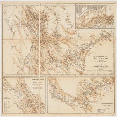
nach dessen Originalskizzen redigirt von H. Kiepert.Covers portions of Turkey, Iraq and Iran.Relief shown by shading.Prime meridian: Greenwich and Paris.Inset: Route in Nord-Persien (Scale 1:600,000).Ancillary maps: Türkish-Persischer Grenzbezirk in Kurdistan im doppelten Maβstab der Hauptkarte (Scale 1:400,000), Der mittlere Theil der Hauptkarte im doppeltem Maβstabe (Scale 1:400,000)."Druck v. Fr. Schwabe, Berlin".Includes lexicon German-Turkish-Persian.In German with place names in Turkish and Persian.Electronic reproduction. Cambridge, Mass. : Harvard College Library Digital Imaging Group, 2009. (Open Collections Program at Harvard University. Islamic Heritage Project). Copy digitized: XXXXX Library: [call no.].